i | P a g e
Internal erosion and piping
failure of landslide dams
OKEKE, Chukwueloka Austin Udechukwu
Department of Geoscience
Interdisciplinary Graduate School of Science and
Engineering
Shimane University, Japan
ii | P a g e
ABSTRACT
Landslide dams are formed in valley-confined settings where favourable geomorphological and hydro-climatic factors result in the downslope movement of weathered slope materials, causing the blockage of river valleys and the creation of barrier lakes. Landslide dams are potentially dangerous natural phenomena, which are made up of heterogeneous masses of unconsolidated or poorly consolidated sediments, and thus may fail by seepage or piping. Failure of landslide dams could trigger catastrophic outburst floods and debris flows, which could inundate the downstream areas, causing loss of lives and infrastructural damage. Therefore, timely evaluation of landslide dams is important for prevention of catastrophic dam failures and mitigation of disasters caused by downstream flooding of the released water masses. This research performs a series of field investigations, flume experiments and large-scale physical experiments to study the potentials for internal erosion and piping failure of landslide dams.
An integrated geophysical approach comprising the microtremor chain array and self-potential surveys were successfully used to characterize the internal structure of landslide dams and delineate potential seepage zones. The microtremor chain array survey results revealed the internal structure of the landslide dams while the self-potential survey results indicated areas of anomalous seepage or zones of high water saturation. In most of the surveyed sites, the presence of an anomalous seepage was confirmed by a very good correlation between the areas of low phase velocities (80 to 200 m/s) and high negative SP anomalies.
A series of experiments were performed to study the hydromechanical constraints for landslide dam failure by piping. The experiments were conducted in a 2m*0.45m*0.45m flume, with a flume bed slope of 5°. Uniform dams of height 0.25 m
iii | P a g e
were built with either mixed or homogeneous silica sands. Two laser displacement sensors were used to monitor the behaviour of the dams during the internal erosion process while a linear displacement transducer and a water-level probe were deployed to monitor the onset of internal erosion and the hydrological trend of the upstream lake. Five major phases of the breach evolution process were observed: pipe evolution, pipe enlargement, crest settlement, hydraulic fracturing and progressive sloughing. Two major failure modes were observed: seepage and piping-induced collapse. It is found that an increase in soil density and homogeneity of the dam materials reduced the potential to form a continuous piping hole through the dams. The rate of pipe enlargement is related to the erodibility of the soil, which itself is inversely proportional to the soil density.
Extensive laboratory experiments were performed to evaluate the critical hydraulic and geometrical conditions for seepage-induced failure of landslide dams. The experiments were conducted in a flume tank specifically designed to monitor time-dependent transient changes in pore-water pressures within the unsaturated dam materials under steady-state seepage. Two critical hydraulic gradients corresponding to the onset of seepage erosion initiation and collapse of the dam crest were determined for different upstream inflow rates, antecedent moisture contents, compactive efforts, grain size ranges, and dam geometries. The deformation behaviour of the dams was significantly influenced by particle density, pore geometry, hydraulic conductivity, and the amount of gravel and pebbles present in the materials. The results indicate that the critical seepage velocity for failure of the dams decreased with an increase in downstream slope angle, but increased with an increase in pore geometry, dam height, dam crest width, upstream inflow rate, and antecedent moisture content.
Large-scale (outdoor) physical experiments were conducted to evaluate the premonitory factors for internal erosion and piping failure of landslide dams. Several monitoring sensors comprising pore-water pressure sensors, linear displacement
iv | P a g e
transducers, and turbidity sensors were installed at different parts of the dam to monitor the hydrodynamic changes that occur during the internal erosion and piping. Furthermore, self-potential measurements were made during the experiments by installing several electrodes on the dam crest. The experimental results indicated that the emergence of a high turbidity (300~450 NTU) effluent seepage at the downstream face of the dam coincided with a very high negative self-potential anomaly. This was also found to correlate with the development of high pore-water pressures (4~8 kPa) which subsequently led to a gradual decrease in the dam height (settlement). These large-scale (outdoor) physical experiments provide important information regarding the premonitory factors for piping failure of landslide dams.
The integration of the geophysical surveys, flume experiments, and large-scale (outdoor) physical experiments provides a framework for a better understanding of the likelihood of piping-induced failure of landslide dams. The results of this comprehensive research would aid in the development of accurate dam breach models for the prediction of the breaching time, flood hydrograph and an early warning system for disaster risk reduction.
v | P a g e
First and foremost, I would like to express my appreciation to my supervisor, Professor Fawu Wang, for his guidance, supervision and encouragement throughout the duration of this project. I thank him immensely for providing me the platform, and relevant mental and academic skills with which to maximize my potentials.
I had the privilege of being under the guidance of Professors Kiyoshi Masumoto, Tetsuya Sakai and Hiroto Ohira, who have with patience, understanding and good humour supported this project. While the research was outside their individual areas of specialization, they demonstrated their readiness to assist me whenever I needed their advice.
I am very grateful to the staff and students of Disaster Prevention Engineering Research Laboratory of Shimane University, especially Messr. Yohei Kuwada, for his immense contributions to my research.
I am grateful to the financial backing from the Ministry of Education, Culture, Sports, Science and Technology (MEXT), Japan for funding this project.
Above all, I thank my dearest wife Ngozi, and son Owen, who have been my source of joy throughout the duration of this project. Their patience, love and understanding were instrumental to the completion of this project.
And finally to my parents and siblings for their unalloyed support and encouragement throughout my academic life in Japan.
vi | P a g e
TABLE OF CONTENTS
TITLE PAGE i ABSTRACT ii ACKNOWLEDGEMENTS v CHAPTER 1 INTRODUCTION 1 1.1 Background 11.2 Objectives and thesis outline 6
1.3 Geomorphic settings for landslide dams 9
1.3.1 The European Alps 10
1.3.2 The Himalayas 13
1.3.3 The southern Alps of New Zealand 16
1.4 Occurrence of landslide dams in China and Japan 18
1.4.1 Landslide dams in China 18
1.4.2 Landslide dams in Japan 20
1.5 Classification of river-damming landslides 27
1.6 Triggering mechanisms of river-damming landslides 28
1.6.1 Implications for longevity and stability of landslide dams 30
1.7 Failure modes of landslide dams 32
1.7.1 Piping 33
1.7.2 Overtopping 34
1.7.3 Slope failure 36
vii | P a g e
2.1 Introduction 37
2.2 Definitions and nomenclature 37
2.2.1 Internal erosion 39
2.2.2 Piping 39
2.2.3 Backward erosion 42
2.2.4 Concentrated leakage erosion 42
2.2.5 Heave (or blow out) 43
2.2.6 Suffusion (Internal instability) 43
2.2.7 Internal migration (Stoping) 44
2.2.8 Contact erosion 45
2.3 Mechanism of internal erosion and piping 45
2.4 Seepage-induced failure of landslide dams and soil slopes 47
2.5 Effects of pore-water pressures on landslide dams and soil slopes 48
2.6 Governing equations for seepage in saturated-unsaturated soils 49
2.7 Effects of seepage gradient forces on landslide dams and soil slopes 52
2.8 The internal structure of landslide dams: implications for piping 55
2.9 Sedimentological classification of landslide dams (Facies analysis) 60
2.9.1 Flims sturzstrom (Swiss Alps) 61
2.9.2 Volcanic natural dams 62
2.9.3 Rock avalanche deposits 62
CHAPTER 3 GEOPHYSICAL INVESTIGATION OF THE INTERNAL STRUCTURE OF LANDSLIDEDAMS 65
3.1 Introduction 65
3.2 Site descriptions 67
3.2.1 Akadani and Kuridaira landslide dams, Japan 67
viii | P a g e
3.2.3 Kol-Tor landslide dam, Kyrgyzstan 70
3.3 Geophysical surveys 71
3.3.1 Microtremor array survey 71
3.3.2 Self-potential survey 74
3.4 Results and discussion 77
3.4.1 Akadani and Kuridaira landslide dams 80
3.4.2 Higashi-Takezawa and Terano landslide dams 85
3.4.3 Kel-Tor landslide dam 91
3.5 Conclusions 93
CHAPTER 4 EXPERIMENTAL INVESTIGATION OF THE HYDROMECHANICAL CONSTRAINTS FOR PIPING FAILURE OF LANDSLIDE DAMS 95
4.1 Introduction 95
4.2 Experimental methods 97
4.2.1 Modification of the flume tank 98
4.2.2 Laser displacement sensors 100
4.2.3 Linear displacement transducer 101
4.2.4 Upstream water level probe 101
4.3 Experimental procedure and properties of the soils used 102
4.4 Results and discussion 108
4.4.1 Observed phases of the breach evolution process 108
4.4.2 Pipe development 108
4.4.3 Pipe enlargement 109
4.4.4 Crest settlement 110
4.4.5 Hydraulic fracturing 111
4.4.6 Progressive sloughing 111
ix | P a g e
4.5.1 Failure mechanisms of dams built with mixed materials 114
4.5.2 Failure mechanisms of dams built with uniform materials 117
4.5.3 Effect of density on erodibility of the dam materials 118
4.6 Natural analogues of seepage and piping in landslide dams 123
4.7 Conclusions 128
CHAPTER 5 EXPERIMENTAL INVESTIGATION OF THE CRITICAL HYDRAULIC GRADIENTS FOR SEEPAGE-INDUCED FAILURE OF LANDSLIDE DAMS 130
5.1 Introduction 130
5.2 Brief review of seepage erosion in soils 134
5.3 Experimental methods 138
5.3.1 Testing facility 138
5.3.2 Soil characteristics 139
5.3.3 Landslide dam model construction and test procedure 140
5.4 Determination of critical hydraulic gradients 147
CHAPTER 6 RESULTS OF CRITICAL HYDRAULIC GRADIENTS FOR SEEPAGE-INDUCED FAILURE OF LANDSLIDE DAMS 150
6.1 General description of the experiments 150
6.2 Influence of dam composition 151
6.3 Rate of inflow into the upstream reservoir 156
6.4 Influence of material condition 158
6.5 Influence of dam geometry 164
6.6 Discussion 166
x | P a g e
CHAPTER 7 EXPERIMENTAL INVESTIGATION OF THE PREMONITORY CONDITIONS FOR
PIPING FAILURE OF LANDSLIDE DAMS 182
7.1 Background 182
7.2 Experimental methods 185
7.2.1 Experimental setup and site descriptions 185
7.2.2 Soil characteristics and dam model construction 187
7.3 Results and discussion 191
7.3.1 Experiment 1 191
7.3.2 Experiment 2 196
7.3.2 Experiment 3 198
7.4 Conclusions 203
CHAPTER 8 CONCLUSIONS AND FUTURE WORK 205
8.1 Major conclusions 206
8.1.1 Geophysical assessment of the internal structure of landslide dam 206
8.1.2 Hydromechanical constraints on piping failure of landslide dams 206 8.1.3 Critical hydraulic gradients for seepage failure 207
8.1.4 Premonitory factors for internal erosion and piping in landslide dams 208
8.2 Recommendations for future work 208
1 | P a g e
CHAPTER 1
INTRODUCTION
1.1 Background
The impacts of climate change and global warming have triggered many natural disasters in numerous mountainous regions of the world. A large number of environmental changes have continued to modify the hydrogeologic system as a result of global warming. Every year, tens of thousands of fatalities are being recorded and several billions of dollars are lost due to damage caused by the prevalence of floods, river-damming landslides, debris flows, earthquakes, glacier outburst floods (GLOFs) and other hydroclimatologically-related disasters. The last two decades have witnessed an increasing trend in the frequency and intensity of precipitation and extremely high temperatures. These effects, in combination with rapid urbanization and deforestation, have triggered several natural disasters including landslides and associated disasters such as catastrophic outburst floods from the failure of landslide dams and glacier-ice dams. The relationships between climate change and the initiation of several geomorphological processes that trigger landslides and other mass movements have been documented in the literature (Bo et al 2008; Jakob and Lambert 2009; Crozier
2010; Stoffel and Huggel 2012). These processes are caused by a change in equilibrium between precipitation and evapotranspiration which alters the hydrologic regime of mountain slopes, triggering landslides that occasionally form secondary hazards such as landslide dams. For these reasons, an interdisciplinary research scheme comprising geomorphology, hydrogeology, hydroclimatology, and disaster risk management needs
2 | P a g e
to be developed and sustained for accurate evaluation and mitigation of natural dam hazards.
Landslide dams represent a significant geomorphic hazard that occurs in many mountainous regions of the world. High frequency of river-damming events has been observed in tectonically active regions of high seismic activity. These regions are usually characterized by favourable topographic boundaries such as oversteepened slopes and narrow valleys. Landslide dams are complex and composite in nature; their origin can be attributed to the blockage of stream-channels in confined valley settings by rock falls, landslides, rock avalanches and debris flows. The major factors controlling the formation of landslide dams are the geometry of the stream-channel, the velocity of the landslide and the volume of the displaced material (sediment budget). A few examples of the earliest historic records of landslide dam formation and failure in the European Alps include the 1219 damming of the Romanche River in France and subsequent failure which led to the downstream flooding that claimed thousands of lives (Bonnard 2011); the 1419 Ganderberg-Passeier Wildsee (Passer Valley, Italy) rockslide dam failure and outburst flood that claimed at least 400 lives; and the 1515 Val Blenio (Switzerland) rock avalanche dam failure and outburst flood that took about 600 lives (Li 1990). In China, two notable records of river-damming events are: (1) the 1737 BC earthquake-triggered landslide dam in the Yi and Lo Rivers in Hunan Province of central China (Xue-Cai and An-ning 1986); and (2) the 1786 M=7.75 earthquake-triggered landslide in Sichuan Province, southwest China, which dammed the Dadu River and breached ten days later, leading to catastrophic flooding of the downstream areas that claimed over 100,000 lives (Dai et al. 2005).
Not much has been reported on the immense contributions of landslide dams in the socioeconomic development of the human society. Rapid urbanization and industrialization witnessed in the 19th and 20th Centuries resulted in the stabilization
3 | P a g e
navigation, recreational activities, water supply, aquaculture and hydropower generation (Heim 1932; Terzaghi 1960; Schuster 2006; Coppola and Bromhead 2008). For instance, the Waikaremoana Lake, located on the east coast of the Northern Island of New Zealand, was formed ca. 2,200 years ago, by a rockslide dam with an estimated dam volume of 5.2 billion m3 (Adams 1981; Davies et al. 2006). This scenic lake which
generates a total output of 124 Megawatts of electricity remains one of the many cases where upstream waters are being utilized for hydroelectric power generation (Read et al. 1992). Other important examples are: (1) the 30 m high Rhodannenberg Dam built on the Klontalersee rockslide dam in Switzerland, which impounds a reservoir with a total volume of 56.4 × 10⁶ m3. This hydropower dam was completed in 2010, with a
capacity of generating 60 Megawatts of electricity; and (2) the 80 m high Zavoj (Pirot) Dam built on the 1963 rockslide dam that dammed the Visocica River in Serbia (Evans et al. 2011).
Landslide dams pose enormous risks because of the potentially catastrophic outburst floods that could be triggered by the sudden release of stored water masses from the failure of the blockage. These floods, upon surging downstream, transform into debris flows and hyperconcentrated flows with peak discharges most times greater than 10,000 m3/s, thereby, threatening the lives of people living in the downstream areas
(O’Connor and Costa 2004). For example, the Diexi landslide dams (Dahaizi, Xiaohaizi and Diexi), formed by deep-seated mass movements triggered by the August 25, 1933, M=7.5 earthquake in northwestern Sichuan Province of China, claimed about 2,423 lives from outburst floods (that travelled with an average velocity of 20~25 km/hr) generated from the breaching of the dams (Chai et al. 2000). Peak discharges are controlled by several factors including dam geometry, downstream topography, failure mode, the internal structure of the blockage and lake volume. Therefore, a good knowledge of the complex processes involved in the evolution and failure of
4 | P a g e
damming landslides, coupled with the hydraulics of the outburst floods, is imperative for disaster risks assessment and mitigation.
Internal erosion and piping are common phenomena occurring in landslide dams and other water-retaining structures such as embankment dams and artificial levees. The prevalence of these processes in landslide dams has been attributed to the anisotropic and heterogeneous nature of landslide dam deposits which are mostly unconsolidated or poorly consolidated. This ultimately increases the probability of initiation of seepage and piping which sometimes results in dam breaching and failure. Seepage erosion triggers slope instability through three major interrelated mechanisms: (1) increase in pore-water pressure and its effects on the shear strength of the soil, (2) increase in seepage gradient forces that reduce the effective stress of the soil, and (3) mobilization and downstream entrainment of the eroded particles.
Internal erosion and piping occur in many geologic materials including clay, silt, fine sand, volcanic ash, tuff, loess, colluvium, alluvium, claystone, siltstone and mudstone (Parker 1964). The development of internal erosion and piping in landslide dams has been attributed to the interplay between the internal structure of the dam and the discharge rate through the impoundment. Internal erosion and piping are usually favored by a coarse blocky carapace with large void spaces where anomalous seepage has the potential to form subsurface conduits or tunnels which acts as channels for the release of the lake waters impounded behind the dam. A typical example is the relatively stable Usoi landslide dam, where the rate of discharge through the dam has equaled the inflow rate into the upstream lake, thus maintaining a static water level which has contributed to the stability of the dam (Strom 2013).
Failure of landslide dams and earthen dams involves a complex, sporadic, nonlinear and homogeneous process (Singh et al. 1988). Hence, a good knowledge of sediment transport processes, including the hydraulics and hydrodynamics is needful for a better
5 | P a g e
understanding of the complex processes that lead to the initiation and development of internal erosion and piping. In general, piping failure of landslide dams has been ascribed to three major interrelated mechanisms: (1) initiation of internal erosion and piping; (2) progressive erosion and removal of sediments at the downstream face under steady-state seepage conditions; and (3) formation of an initial breach at the crest and subsequent enlargement by erosion (Singh et al. 1988). A lot of difficulties have been reported by researchers while simulating the internal erosion process which has been recognized as an important factor for the determination of the extent, magnitude and duration of the flood hydrograph. Timely assessment of landslide dams and prediction of the potential flood hydrograph are essential for effective planning and implementation of disaster management schemes. Similarly, a large number of results abound on numerical models developed for the simulation of piping in earthen dams and landslide dams (Singh et al. 1988; Gattinoni and Francani 2009). Yet, none of these methods have investigated the influence of hydromechanical properties of landslide dams on their potential failure mechanisms as relates to internal erosion and piping. One major problem in dam engineering is the monitoring of seepage, especially in heterogeneous and anisotropic materials. Information on seepage processes (seepage velocity, seepage forces, seepage paths and hydraulic conductivity) are essential for predicting the hydraulic behaviour and the failure mechanism of landslide dams. The internal structure and the hydraulic behaviour of landslide dams can be assessed by the application of several geophysical exploration techniques. The microtremor (MTM) chain array survey and the self-potential (SP) measurement are two non-invasive geophysical techniques that are sensitive to soil and fluid properties. These techniques can be used to evaluate contrasting specific subsurface properties that can be attributed to varying seepage conditions. Hence, data acquired from the application of these geophysical techniques can be used wholly or in part to produce a representative image of the hydraulic conditions and the internal structure of the impoundment.
6 | P a g e
1.2 Objectives and thesis outline
The purpose of the present research is to study the mechanisms of internal erosion and piping in landslide dams. This thesis is focused on the following four main objectives.
1. To determine the apparent phase velocity structure of landslide dams and evaluate their internal structure, stability and the potential for failure by piping. This is achieved through carrying out microtremor chain array surveys on selected landslide dams using a set of seismometers, 3 reels of connecting wires, a data logging device, portable batteries and laptop computers installed with a data logging software.
2. To identify zones of anomalous seepage that could likely develop into internal erosion, and provide information on the subsurface geologic structures influencing groundwater flow and seepage conditions. This is achieved through the conduction of self-potential investigations using Copper-Copper Sulphate (half-cell) reference electrodes.
3. To identify the various failure mechanisms of landslide dams under varying hydromechanical properties of the materials forming the dams, and to evaluate the geometric and hydraulic factors governing the onset of internal erosion and piping. This is achieved by performing a series of experiments in a flume tank equipped with monitoring sensors and transducers, using materials of differing physical properties.
4. To determine the critical hydraulic gradients for the onset of internal erosion and failure of landslide dams under differing hydraulic and geometrical conditions. This is achieved by using several precision sensors to track the transient hydraulic conditions in dam models of varying geometrical and physical properties subjected to steady-state seepage conditions.
7 | P a g e
5. To investigate the premonitory conditions for internal erosion and piping in landslide dams, and to examine the relationship between the transient deformation behaviour of the dams and turbidity of the seepage water. This task is accomplished by performing large-scale (outdoor) model tests using strain gauges and laser displacement sensors to monitor the internal and external deformations that occur during internal erosion. Furthermore, turbidity sensors and pore-water pressure transducers will be used to track the onset of internal erosion and the dynamic behaviour of the dam models during piping.
The main body of this thesis comprises eight chapters. Chapter 1 introduces the research topic, states the major research objectives and discusses the geomorphic settings for landslide dams, including the triggering mechanisms of river-damming landslides and the failure modes of landslide dams.
Chapter 2 presents a comprehensive review of the literature on internal erosion and piping processes in landslide dams and soil slopes. This chapter comprises detailed definitions and nomenclature of the piping process; the various classifications of piping and mechanisms of internal erosion and piping are discussed. Furthermore, the mechanisms of seepage-induced failure of landslide dams and soil slopes are summarized, including the effects of pore-water pressures on the destabilization of soil slopes. The effects of seepage gradient forces on soil materials and the internal structure of landslide dams, considering its implications on the initiation of piping are presented as well.
In Chapter 3, an integrated geophysical approach is employed to characterize the internal structure of selected landslide dams and to study the variations in specific physical properties of the soil that could provide information on the potential zones of anomalous seepage. Field investigation results using the microtremor chain array and the self-potential techniques are presented and discussed. Analysis of the results
8 | P a g e
involves a detailed description of the internal structure of the dams based on variations in phase velocities and the identification of likely seepage zones in the dams.
Chapter 4 presents the results of a series of laboratory experiments on the hydromechanical constraints on the piping failure of landslide dams. The experimental programme, including the apparatus, materials and procedure are described. The test results, including the various breach evolution processes, the effect of density on erodibility of the materials and the characteristic failure mechanisms under differing materials are discussed.
Chapter 5 presents a series of experiments performed to determine the critical hydraulic gradients for the seepage-induced failure of landslide dams under varying physical properties of the dam materials. In addition, the details of the modified flume tank used in the investigation, including the soil characteristics, experimental procedure, and method adopted for the determination of critical hydraulic gradients are described.
Chapter 6 presents the results of the experimental investigation reported in Chapter 5. The variations in critical hydraulic gradients for the initiation of internal erosion and collapse of the dam crests under differing hydromechanical and geometrical conditions are described. In addition, the hydraulic behaviour of the dam models under steady-state seepage conditions, and the effects and variation of pore-water pressures and seepage velocities are discussed.
Chapter 7 presents the results of a series of large-scale (outdoor) experimental investigations performed to study the premonitory conditions for internal erosion and piping failure of landslide dams. The variations in turbidity of the seepage water with respect to the deformation behaviour of the dam models are discussed. Finally, Chapter 8 presents the present research findings and recommendations for further research.
9 | P a g e
A lot of studies have been done on the relationships between fluvial processes and the frequency of landslide damming events in connection with sediment delivery processes and the development of drainage networks (Whitehouse and Griffiths 1983; Hammack and Wohl 1996; Cenderelli and Kite 1998; Hewitt 1998; Hovius et al. 1997, 1998). Landslide dams are formed by the partial or complete blockage of stream-channels by displaced earth or rock materials. The phenomenon can occur in several kinds of geomorphic settings. These settings are usually characterized by steep-walled narrow valleys bordered by high rugged mountains; a feature commonly found in geologically active regions where uplift or mountain building associated with active tectonic activities increases the likelihood of initiation of river-damming landslides (Costa and Schuster 1988). Also, these regions are characterized by highly weathered and unstable source materials, including fractured and hydrothermally altered bedrock, and thick Quaternary sediments. The majority of the inherent factors that trigger landslide damming events in these regions include increases in local relief and hillslope gradient, and incessant weathering that reduce the shear strength of hillslope materials. These overarching factors are exacerbated by high orographic precipitations or snowmelts, coupled with active tectonic activities including earthquakes and volcanic eruptions. The probability of formation of landslide dams is determined by several factors including the volume of the displaced material (sediment budget), the type of landslide, the velocity of the displaced material, and morphology of the stream-channel. Schuster et al. (1998) enumerated four kinds of factors that govern the spatial distribution of landslide dams based on the study of the landslide dams formed by the 1989 Loma Prieta earthquake in California (USA). These factors are (1) seismic intensity (peak acceleration, duration of strong motion), (2) topography and high slope gradient, (3) lithology and weathering, and (4) soil moisture and groundwater content.
Geodynamically active regions where landslide dams form are characterized by orogenic processes (mountain building), which evolve from crustal shortening, vertical
10 | P a g e
thickening, and denudation processes. These processes are augmented by other essential factors such as earthquakes and orographically enhanced precipitation on steep narrow gorges. The evolution of mountain belts at tectonic boundaries results in the development of narrow stream-channels and gorges which are bordered by steep hillslopes. Most significantly, a large number of these gorges and stream-channels are V-shaped, implying the effects of strong tectonic activity on river incision, which obviously leads to the geomorphological alteration of the postglacial terrain (Korup
2005). From past historical records, notable geomorphic regions where landslide dams are prevalent include the Andes of South America (Porter and Savigny 2002; Schuster et al. 2002), the European Alps (Huggel et al. 2002; Casagli et al. 2003; Crosta et al. 2013), the Himalayas (Hewitt 1998;Richardson and Reynolds 2000), the Canadian Cordillera (Clague and Evans 1994;Geertsema et al. 2006), the mountains of Central Asia (Strom
2010, 2013), the mountainous margin of the Tibetan Plateau (China) (Ouimet 2007; Korup and Montgomery 2008), and the Southern Alps of New Zealand (Korup et al.
2004, 2006). A brief summary of the tectonic evolution of some of these regions is given below.
1.3.1 The European Alps
The European Alps are the highest and largest mountain belts in Europe, extending more than 1000 km from the French and Italian Mediterranean coasts across Switzerland, northern Italy, and Austria into the central parts of the European continent. Numerous catastrophic events associated with rock avalanche processes, landslide dams, glacier-ice dams and moraine dams have been recorded in many parts of the European Alps (Allen et al. 2011; Huggel et al. 2012; Stoffel and Huggel 2012; Crosta et al. 2013). These have been related to the orogenic processes that lead to mass accretion into the mountains, followed by isostatic uplifts, hillslope erosion processes that lead to high sediment yield, and the evolution of relief. Historical records of events
11 | P a g e
predating the 13th Century indicate that several catastrophic disasters such as glacial
lake outburst floods (GLOFs), were triggered from the failure of many natural dams formed by deep-seated landslides, ice, snow and rock avalanches, and sturzstroms in many parts of the Western European (Swiss) Alps (Costa and Schuster 1988; Wassmer et al. 2004; Pollet and Schneider 2004; Gutiérrez 2005, pp. 548~550).
The tectonic style of the European Alps is characterized by a complex pattern of overthrusted nappes (Fitzsimons and Veit 2001; Kühni and Pfiffner 2001). The Alps evolved from continental convergence and collision between the Adriatic microplate (the smaller part of the African Plate) and the European Plate. The collision resulted in the southward subduction of the Penninic Ocean and subsequent intra-plate (continent-continent) collision during the Tertiary (Schmid and Kissling 2000). These orogenic processes resulted in the overthrust of the European continental margin (Helvetic domain) by the African continental margin (Australoalpine domain) (Figure
1.1). The orogenic processes that led to the evolution of the entire Alps into a high mountain range are as a result of isostatic compression and exhumation of the lighter continental crust (Bernet et al. 2001). Consequently, the topography of the Alps is roughly symmetrical, with the highest mountain summits in the central region. The mountain range of the Alps is characterized by a crystalline core comprised of pre-Alpine magmatic rocks and polymetamorphic sediments overlain by Mesozoic and Cenozoic metasedimentary sequences, both of which constitute the Penninic and Helvetic thrust nappes (Wittmann et al. 2007). Other major tectonic units in the Alps include the Jura Mountains, the Molasse Basin, the nappe complexes of the Austroalpine and Southalpine zones, and the Po Basin (Kühni and Pfiffner 2001). The Southern Alps are separated from the Central Alps by the Tonale Line, which is an E-W trending portion of the Insubric Line (Schmid et al. 2004). Due to strong tectonic compression and deep incision of the Lepontine area, the mountain range of the Western (Swiss) Alps is narrower with higher elevations (4,807 m at Mont Blanc) than
12 | P a g e
the Eastern Alps (Fitzsimons and Veit 2001). The prevalence of many catastrophic geomorphic processes in the Alps has been linked to several large-scale European climate patterns, coupled with the steep relief and elevation of the Alps (Frei and Schär
1998; Auer et al. 2005). All these have been included in the predisposing factors for the high frequency of occurrence of deep-seated landslides and landslide dams, glacier-ice dams and moraine dams in the Alps.
Figure 1.1 Geologic map of the European Alps (http://erdwissenschaften.uni-graz.at)
1.3.2 The Himalayas
The Himalayas are a geodynamically active region which is susceptible to extreme crustal activity that causes earthquakes. For this reason, denudation processes and natural damming of stream-channels and gorges are common phenomena in the region. The resultant effects have triggered several catastrophic outburst floods released from the breaching of landslide dams, glacier-ice dams and neoglacial moraine dams (Richardson and Reynolds 2000; Mool et al. 2001; Hewitt 2011). Most significant
13 | P a g e
among these natural disasters are glacial lake outburst floods (GLOFs), which commonly occur in many river basins of the Nepal Himalaya, at altitudes of 4500~5500 m a.s.l. (Kattelmann 2003).
The evolution of the Himalayan mountain range began around 65 Ma as a result of the intra-plate (continent-continent) collision between the Indian and Eurasian Plates, along the Indus-Zangbo Suture Zone (Korup et al. 2006). For this reason, the Himalayan mountain range is characterized by a complex aggregate of structurally deformed and highly metamorphosed lithologic units which bear imprints of various stages of tectonic occurrences (Figure 1.2; Yin 2006). Partly forming the summits of the highest peaks on earth (Mt. Everest, 8848 m a.s.l.), is a 10~17 km thick unmetamorphosed parautochthonous sedimentary sequence of the Tibetan Himalaya (Proterozoic-Eocene) (Korup et al. 2006; Weidinger 2011). Further south abounds crustal thrust planes formed within the Indian Plate at 20~25 Ma (Weidinger 2011). The Main Central Fault (MCT), which is a longitudinal thrust fault characterized by mylonitization and retrograde metamorphic assemblages, delineates the boundary between the Higher Himalayas and the Lesser Himalayas (Yin 2006; Webb et al. 2007). The Higher Himalayas (or Greater Himalayan Crystalline Complex) mark the axis of orogenic uplift and signify a multiphase deformational event, which is mainly composed of ductily deformed metamorphic rocks including quartzite, migmatite, paragneiss and mica schists (Gehrels 2003; Wang et al. 2013). The Main Boundary Thrust (MBT) marks the southernmost tectonic boundary where the unmetamorphosed clastic rocks of the Miocene-Pliocene Himalayan foredeep comprising the molasse-type Siwalik Formation are overthrust by the nappe systems (comprised of metasedimentary rocks) of the Lesser Himalayas (Meigs et al. 1995; Robinson et al. 2006). The southern end of the Himalayan foredeep (Sub-Himalayan sequence) is bordered by the Main Frontal Thrust (MFT), which uplifts sediments of
14 | P a g e
the Siwalik Group southward over the Indo-Ganjetic plain (Baker et al. 1988; Wesnousky et al. 1999;DeCelles et al. 2001; Yin 2006).
The principal factors that favour the occurrence of natural dams in many parts of the Himalayas stem from the high rate of exhumation of about 1~15 mm/year and the high topographic relief (Korup et al. 2006). This is exacerbated by the summer monsoon rainfall (1500 mm/yr~6000 mm/yr) that results in high fluvial processes and sediment yield of 102 − 104 t km-2/yr (Korup et al. 2006). Most noteworthy is the fact that the
duration and intensity of precipitation are orographically controlled by the barrier formed by the Himalayan mountain chain (Bookhagen et al. 2005; Wulf et al. 2010). The occurrence of deep-seated slope deformations and giant rock flows within pre-existing fissures and joints have continued to modify the Himalayan postglacial terrain (Figure 1.3; Korup et al. 2006). Similarly, the high frequency of formation of glacier dams and moraine dams in many parts of the Himalayas (Delany and Evans 2011; Weidinger 2011), and in the headwaters of the Indus and Tsangpo rivers have been attributed to a dynamic coupling between the rate of erosion and exhumation in the cores of the Himalayan Syntaxes (Korup et al. 2010;Hewitt 2009, 2011).
15 | P a g e
16 | P a g e
Figure 1.3 Source area of the May 2012 rock fall and avalanche into the Seti River Gorge
in the Nepal Himalaya. The rocks in the source area are highly tilted metamorphosed sedimentary rocks which are covered with snow (Image source: NASA earth observatory file image)
1.3.3 The Southern Alps of New Zealand
Historical records of landslide dam formation in New Zealand show that a large number of these events occur in the Southern Alps. The types of landslides that form these dams are predominantly deep-seated block slides and rock avalanche processes (Whitehouse and Griffiths 1983; Korup 2005; Allen et al. 2009, 2011). The southern part of New Zealand is straddled by a 500 km-long mountain range of the Southern Alps, which evolved from an oblique continental collision of the Indo-Australian Plate and the Pacific Plate, primarily along a 600 km Alpine Fault (Figure 1.4) (Kamp and Tippett
1993; Sutherland 1995). The collision resulted in the upturning and rapid exhumation of the leading edge of the Pacific Plate which is comprised of partly metamorphosed
17 | P a g e
greywacke of the Torlesse Terrane (Fitzsimons and Veit 2001; Herman et al. 2007). High rate of uplift (5~8 mm/yr) along the plate boundary resulted in the formation of a mountain range, which is characterized by an asymmetrical cross-section with sharp topographic expressions, deeply dissected valleys and peak summits higher than 3000 m a.s.l., a few kilometers from the Tasman Sea (Fitzsimons and Veit 2001).
Figure 1.4 Tectonic and topographic map of the South Island of New Zealand
(Castelltort et al. 2012)
The mountain range of the Southern Alps is considerably young and is being modified by high uplift forces and denudation processes. High fluvial sediment yield of 102~104 t/km2/y from the western Southern Alps (WSA) has been related to the
18 | P a g e
erosion and debris avalanche processes (Whitehouse 1988; Korup et al. 2006). This is because precipitation is orographically enhanced, especially at the steeper faces of the western divide where up to 14,000 mm/y of rainfall has been recorded (Henderson and Thompson 1999). Highly glaciated landforms dominate the axial Southern Alps (ASA), while the eastern divide (ESA) are predominated by intermontane basins and broad valleys where huge volumes of glacigenic deposits are preserved (Korup 2011).
1.4 Occurrence of Landslide Dams in China and Japan
1.4.1 Landslide Dams in China
Several forms of natural disasters frequently occur in China, most times resulting in an untold number of deaths and infrastructural damage worth several billions of Chinese RMB. High frequency of occurrence of landslides and river-damming events in most parts of China has been attributed to the complex geological structure of many Chinese mountain regions including the Loess Plateau area, the Hengduan mountain areas of Southwest China, as well as in the Provinces of Hubei Xizang, Guizhou, Sichuan, Gansu, Shaanxi, Yunnan and Shanxi (Li 1990). These rugged mountains are characterized by high rates of rock weathering and mass shattering, coupled with orographically enhanced precipitation of high intensity and frequent earthquakes which make up the predisposing factors for the occurrence of landslides and landslide dams (Li 1990).
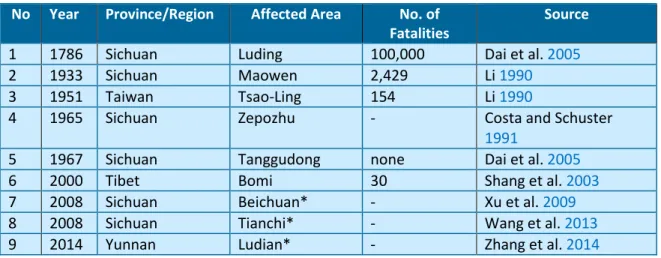
Historical records of geomorphic disasters in China indicate that the occurrence of landslides and landslide dams predates the 11th Century BC (Table 1.1). The June 11, 1786,
landslide dam disaster which occurred in Luding area, Sichuan Province of China, remains the worst recorded landslide dam disaster in the world. This landslide dam was triggered on June 1, 1786, by the Mw 7.75 earthquake in the Kangding-Luding area. The landslide dammed the Dadu River and failed ten days later resulting in
19 | P a g e
catastrophic outburst floods that traveled downstream, claiming about 100,000 lives (Dai et al. 2005).
Table 1.1: Selected historical cases of landslide dam disasters in China
No Year Province/Region Affected Area No. of Fatalities
Source
1 1786 Sichuan Luding 100,000 Dai et al. 2005
2 1933 Sichuan Maowen 2,429 Li 1990
3 1951 Taiwan Tsao-Ling 154 Li 1990
4 1965 Sichuan Zepozhu - Costa and Schuster
1991
5 1967 Sichuan Tanggudong none Dai et al. 2005
6 2000 Tibet Bomi 30 Shang et al. 2003
7 2008 Sichuan Beichuan* - Xu et al. 2009
8 2008 Sichuan Tianchi* - Wang et al. 2013
9 2014 Yunnan Ludian* - Zhang et al. 2014
On April 9, 2000, a huge landslide with a volume of 3 × 10⁸ m3 occurred in the Zhamu
Creek, in Bomi county, the southeastern region of Tibet (Shang et al. 2003). The entire drainage area of the Zhamu Creek is 20.2 km2, with length, width and mean
longitudinal slope of 9.7 km, 50~200 m, and 52.6%, respectively. The high occurrence of landslides in the area has been attributed to the collision between the Indian plate and the Eurasian plate, resulting in an uplift- and slip rate of 3 mm/year and 10 mm/year, respectively. The landslide evolved as a wedge failure and entrained colluvial materials downstream before transforming into a debris flow that subsequently blocked the Yigong River (Figure 1.5b). The landslide dam occupied an area of 2.5 km2, with minimum and maximum heights of 60 and 100 m, respectively,
and minimum and maximum bottom widths of 2200 and 2500 m, respectively. The upstream and downstream slope angles of the impoundment were 5 and 8, respectively. Prior to the breaching of the landslide dam, remote sensing images analyzed by Shang et al. (2003) provided evidence of the likely occurrence of piping and seepage at the downstream end of the blockage. However, the landslide dam was
20 | P a g e
overtopped by the upstream lake 62 days after its formation resulting in about 30 deaths and causing a large number of damage to infrastructures (Figure 1.5c).
The devastating effects of the Ms 8.0 Wenchuan earthquake resulted in a large number of landslide dams in the Sichuan Province of China. The earthquake occurred in the Longmenshan mountain range at exactly 14:28 (Beijing time) on May 12, 2008 (Figure 1.6). The epicenter was located on the north-east trending Longmenshan thrust fault zone (LTFZ) at a focal depth of 14~19 km (an active crustal region) (Fan et al. 2012), as a result of the collision between the Indian plate and the Eurasian plate (Dai et al. 2011). Data analysis revealed that a total number of 828 river-damming landslides were triggered by the earthquake (Fan et al. 2012); 61% of these resulted in complete blockage of rivers, while 39% caused partial blockage and stream-channel diversion. Although a good number of these natural blockages had not failed as at the time the database was generated, studies carried out by Xu et al. (2009) indicated that some of these dams could potentially fail by seepage and piping, considering the nature of the materials composing them.
1.4.2 Landslide Dams in Japan
The Japanese archipelago is located within the Pacific Ring of Fire where frequent crustal movements (tectonic activities) have resulted in a large number of earthquakes and volcanic eruptions. The geologic and geomorphic features of the Japanese Islands are being modified by the subduction of the Pacific Plate and the Philippine Sea Plate. These have triggered several natural disasters including earthquakes, volcanic eruptions, typhoon-induced landslides and debris flows, and catastrophic outburst floods (Sassa 1998, 2005; Chigira and Yagi 2006; Hayashi et al. 2013).
21 | P a g e
Figure 1.5 Time history of formation and failure of the Yigong landslide dam. a. Yigong River before the damming
event b. Post-damming setting of the Yigong River c. Post-failure setting of the Yigong River (Image credit: NASA Earth Observatory)
22 | P a g e
Figure 1.6 Topographic map of the Longmenshan mountain range and surrounding
region showing the distribution of main shocks and aftershocks of the 2008 Wenchuan earthquake (Image: NASA Earth Observatory)
The Japanese Islands are characterized by steep and rugged watersheds coupled with high-intensity rainfall and snowmelts. These characteristic features have resulted in high fluvial processes in many mountain slopes which initially, have been destabilized by repeated earthquake ground motions. Oguchi et al. (2001) identified 6(six) major geomorphological and hydrological variables influencing the rate of fluvial processes in Japan. These include high-intensity precipitation, catastrophic hydro-geomorphological events associated with earthquakes and volcanic eruptions, high sediment yield, steep watersheds, large flood discharge and efficient transport, and frequent slope failures and landslides.
23 | P a g e
The occurrence of landslide dams in several part of the Japanese Islands has been attributed to the abundance of steep and unstable mountain slopes with average modal angle of 35 (Katsube and Oguchi 1999), high-gradient streams, narrow gorges, coupled with frequent hydrologic and seismic events (Swanson et al. 1986; Oguchi et al. 2001). Historical data from Tabata et al. (2002) and Inoue et al. (2013) indicated that the occurrence of landslide dams in Japan predates the 9th Century BC, and occurred
mostly in active tectonic boundaries. A typical example is the high distribution of landslide dams in Northern Nagano Prefecture, Japan (Table 1.2). The occurrence of landslide dams in this region has been attributed to the geomorphic history of the area which is located in the great central belt of Japan (the Fossa Magna) (Mizuyama et al. 2011; Inoue et al. 2013).
The 1847 Zenkoji Earthquake ( 𝑀𝑠 7.4 ) and the 1858 Hietsu Earthquake ( 𝑀𝑠 7.1 )
triggered two mass movements that dammed the Sai River and the Joganji River. The high sediment (ca. 1.3 to 2 × 10⁸ m3) yielded from the latter event resulted in the
failure of the landslide dam and consequently caused several damages due to the release of the impounded waters which resulted in catastrophic outburst floods.
Table 1.2: Historical data of landslide dams in Northern Nagano Prefecture, Japan
(Mizuyama et al. 2011)
N o
Landslide Dam Date Formed Causative factor Longevity Dammed River
1 Aoki Lake 30,000 years ago Unknown Still existing R. Takase 2 Old Chikuma 22-8-887 Goki Shichido
Earthquake
303 days R. Chikuma 3 Old Aiki 20-6-888 Secondary debris
avalanche
600 years R. Aiki 4 Kashima River 7-1441 Heavy rain 3 days R. Kashima 5 Mt. Manaita 28-1-1502? Essa Earthquake Unknown R. Hime 6 Mt. Shimizu 28-1-1502? Essa Earthquake Unknown R. Nakatani 7 Mt. Iwato 28-4-1714 Shinshu Otari
Earthquake
24 | P a g e
8 Tobata 24-6-1757 Heavy Rain 54 hours R. Azusa
9 Mt. Iwakura 08-5-1847 Zenkoji Earthquake 19 days R. Sai 10 Kiriake 08-5-1847 Zenkoji Earthquake Failed
gradually
R. Nakatsu 11 Mt. Amamizu 08-5-1847 Zenkoji Earthquake A few days R. Shinano 12 Yanakubo Lake 08-5-1847 Zenkoji Earthquake Still existing R. Yanakubo 13 Ikari 08-5-1847 Zenkoji Earthquake 16 days R. Dojiri 14 Somuro 08-5-1847 Zenkoji Earthquake Failed
gradually
R. Somuro 15 Oyasawa 08-5-1847 Zenkoji Earthquake Unknown R. Susobana 16 Garagara Sawa 16-6-1891 Heavy Rain Failed
gradually
R. Matsu 17 Mt. Hieda 08-8-1911 Heavy Rain 3 days R. Hime 18 Taisho Lake 06-6-1915 Volcanic Eruption Still existing R. Azusa 19 Mt. Kazahari 21-4-1939 Snowmelt - Flood Failed
gradually
R. Hime 20 Mt. Akahage 04-5-1967 Snowmelt - Flood 101 days R. Odokoro 21 Mt. Kozuchi 16-7-1971 Heavy Rain Failed
gradually
R. Hime 22 Oku Susobana 05-5-1997 Snowmelt - Flood Still existing
due to engineered spillway
R. Susobana
The October 23, 2004, Mid Niigata Prefecture earthquake (𝑀𝑤 = 6.8) triggered
thousands of all kinds of landslides. As many as 30 small-scale landslide dams were formed in the Imogawa River and adjoining tributaries (Chigira and Yagi 2006). The data excludes those formed by deep-seated mass movements that created huge blockages in the Imogawa River, especially in Higashi-Takezawa and Terano districts. Many of the small-scale landslide dams breached several hours after their formation. Their short lifespan has been related to the materials forming the dams which were mostly comprised of highly weathered bedrock and regolith (Wang et al. 2007). However, emergency countermeasure works (construction of spillways, water diversion pipes/tunnels, and installation of drainage 12 pumps) were carried out on the Terano and Higashi-Takezawa landslide dams to avert potential dam breaching and the release of water from the impounded lakes upstream of the dams (Sassa 2005).
25 | P a g e
The passage of a severe tropical cyclone, Typhoon Talas (named Typhoon No. 12 in Japan), over the Japanese archipelago in September 2011 brought cumulative precipitation of 1,000 to 1,500 mm in the southern part of the Kii Peninsula, and 2,436 mm in 5 days in some districts in Nara Prefecture. The Kii Peninsula of Japan has been considered as one of the regions prone to deep catastrophic landslides and associated mass movements (SABO 2010). The arrival of the cyclone destroyed inhabited areas and affected municipal buildings, leading to a severe infrastructural damage worth close to $600 million USD. Data obtained from erosion and sediment control division of the Ministry of Land, Infrastructure, Transport and Tourism showed that in Nara Prefecture alone, 14 fatalities were recorded while 10 people were declared missing. About 13 houses were inundated by debris flows and floods, 50 houses were completely destroyed while 70 houses were partially destroyed. Wakayama Prefecture recorded 52 deaths with 5 people declared missing. A total of 1,985 houses were partially destroyed, and a record 2,642 buildings were flooded, with the complete destruction of 365 buildings (Fujita 2012). About 207 landslides, landslide dams, debris flows and other sediment-related disasters were triggered in 21 prefectures with Mie, Nara and Wakayama Prefectures recording the highest number of cases. The volume of sediments produced by the effect of the cyclone was estimated to be about 100 million m3 (Hayashi et al. 2013). Field investigations carried out immediately after the disaster
confirmed that deep catastrophic landslides were triggered in 72 locations and 17 landslide dams were formed in different locations as a result of these deep-seated movements, five of which were discovered to be at risk of failure due to the rate of increase in the level of the barrier lakes created by the impoundments (Figure 1.7 and
26 | P a g e
Figure 1.7 Distribution of 17 landslide dams triggered by Typhoon Talas in the Kii
Peninsula. The images in red borders represent dams where emergency investigations were carried out (Hayashi et al. 2013).
Figure 1.8 Locations of the 5 landslide dams selected for emergency investigations
27 | P a g e
1.5 Classification of river-damming landslides
Many river-damming landslides have been classified based on the general classification scheme proposed by Cruden and Varnes (1996) in their classification of landslides, with emphasis on the type of movement and the material involved (Table
1.3). Notable research on the classification of river-damming landslides has been completed by Costa and Schuster (1988), who identified a wide variety of mass movements that cause river-damming events. Costa and Schuster found that a large number of landslide dams were caused by avalanches, slumps, and slides, and flows. Similarly, the dataset of more than 500 landslide dam cases collected from around the world by Costa and Schuster (1991), and Schuster (1993) found that more than 50% of the dams were formed from earth slumps and slides; ca. 25% by debris, mud or earth flows; ca. 19% by rock or debris avalanche; and ca. 6% shared by sensitive-clay failures and by rock and earth falls. The results above were corroborated by a more recent study by Peng and Zhang (2012), using a dataset of 1,239 landslide dam cases.
Table 1.3: Classification of landslides based on the type of movement and material
(Cruden and Varnes 1996)
Type of Movement
Type of Material
Bedrock Engineering Soils
Predominantly Coarse Predominantly Fine
Fall Rock Fall Debris Fall Earth Fall
Topple Rock Topple Debris Topple Earth Topple Slide Rock Slide Debris Slide Earth Slide Spread Rock Spread Debris Spread Earth Spread
Flow Rock Flow Debris Flow Earth Flow
The authors found that a total of 469 landslide dam cases (37.9%) were caused by rock and soil slides or slumps; 396 (32.0%) by unknown causes; 180 (14.5%) by rock and debris avalanches; 164 (13.2%) by mud, debris and earth flows; 19 (1.5%) by rock and debris falls; and 11 (0.9%) by other types of mass-movements such as lateral spreads
28 | P a g e
and volcanic eruptions (Figure 1.9). Costa and Schuster (1988) noted that the insignificant number of landslide dams formed from falls can be attributed to the volume of the material representing this type of landslide damming mechanism.
Figure 1.9 Types of landslides that have formed landslide dams based on 1,239 cases
histories inventoried by Peng and Zhang (2012)
1.6 Triggering mechanisms of river-damming landslides
The triggering of mass movements involves an external stimulus which causes an abrupt increase in stress or reduction in strength resulting in a near immediate response in the form of a landslide (Wieczorek 1996). The three most significant triggering mechanisms of landslide dams are high-intensity rainstorms, snowmelt, and earthquakes. Schuster et al. (1998) identified four groups of factors that control the spatial distribution of landslide dams formed by the 1989 Loma Prieta (California) earthquake. These include (1) seismic intensity, (2) hillslope gradient and topography, (3) lithology and weathering properties of the rock material, and (4) soil moisture and groundwater. In some cases, the unavailability of data on triggering mechanisms and
29 | P a g e
types of river-damming landslides emphasize the discrepancies associated with documentation of landslide dam inventory. For instance, the examination of 𝑛 = 232 landslide dams from New Zealand inventoried by Korup (2004) indicated that 59% of the triggering mechanisms remained unknown, 28% were triggered by earthquakes, 11% by coseismic ground motions, 3% by high-intensity rainstorms (tropical cyclones), and 3% from fluvial undercutting, anthropogenic activities, or less obvious mechanisms.
There seems to be a strong link between the temporal occurrence of landslide dams and climatic and/or seasonal rainfall patterns. This assertion has been observed from the datasets of 353 case histories of landslide dams mostly from Italy, Japan, Canada, USA and New Zealand (Figure 1.10). The result showed that 47% of the inventoried dams were triggered by rainfall events, while 34% were triggered by earthquakes (Ermini and Casagli 2003). Similarly, the database of 1,239 cases of landslide dams revealed that rainfall (42%, 517 cases) and earthquakes (40%, 500 cases) were the most dominant causes of landslide dams (Figure 1.11; Peng and Zhang 2012).
Figure 1.10 Subdivision of the 353 inventoried landslide dam cases according to the
30 | P a g e
Figure 1.11 Triggering mechanisms of river-damming landslides based on 1.239 cases
inventoried by Peng and Zhang (2012)
1.6.1 Implications for longevity and stability of landslide dams
The longevity of landslide dams has been a principal subject in many natural dam hazard evaluation studies. The internal structure of landslide dams has been regarded as the major factor controlling the longevity and stability of landslide dams (Costa and Schuster 1988;Dunning and Armitage 2011). The time of failure of landslide dams and the magnitude of the outburst floods depends on the internal characteristics of the impoundment, such as the grain size distribution, grain shape, degree of consolidation, presence of subsurface discontinuities, erodibility, and percentage clay content (Schuster 1995; Bromhead et al. 1996). Landslide dams composed of large-sized angular boulders or cohesive clays are less likely to fail than less consolidated or highly permeable impoundment materials. Of all the existing landslide dams in the world, the Usoi landslide dam in southeast Tajikistan remains the highest known natural dam, with a lifespan of 104 years. The dam was formed by the 1911 Ms 7.4 Sarez earthquake, which triggered rockslides that inundated the Murghab Valley in Tajik
31 | P a g e
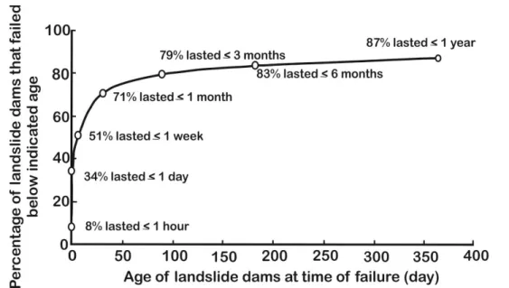
Pamir. Seepage and piping were observed in the dam, but these have been regarded as of no threat to the downstream area (Schuster and Alford 2004). The short lifespan of many landslide dams, unlike constructed embankment dams, has been attributed to the absence of breach prevention measures such as filter zones and water barriers to prevent piping, and drain zones to control pore-water pressures. Also, the absence of channelized spillways in landslide dams leads to overtopping, which is the predominant failure mode of natural dams (Costa and Schuster 1988). However, some landslide dams do not fail quickly, lasting for months or years. For example, the longevity of 204 cases of landslide dams inventoried by Peng and Zhang (2012) indicated that 34% of the cases lasted less than 1 day while 87% lasted less than 1 year (Figure 1.12).
Figure 1.12 Length of time before failure of landslide dams based on 204 cases (Peng
and Zhang 2012)
The longevity and stability of landslide dams can be related to the type of landslide that formed the dam and the triggering mechanism that initiated the movement. The dataset of 353 landslide dams cases inventoried by Ermini and Casagli (2003) revealed
32 | P a g e
that landslide dams formed as a result of earthquakes (57% unstable; 43% stable) and snowmelt (54% unstable; 46% stable) were more stable than those triggered by rainfall events (80% unstable; 20% stable). Similarly, landslide dams formed by translational movements were more stable than those formed by rock avalanche processes (Figures
1.10 and 1.13).
Figure 1.13 Types of landslides that have created landslide dams based on 353 cases
histories documented by Ermini and Casagli (2003)
1.7 Failure Modes of Landslide Dams
Landslide dams are mostly made up of large volumes of displaced materials which sometimes vary between 106~108 m3 (Evans 2011). For this reason, the failure of
landslide dams involves the initial release of sediments and debris before the development of a complete breach. There are three major modes of failure of landslide dams. These are overtopping, piping and slope failure (Costa and Schuster 1988). The failure modes of landslide dams share similar characteristics to those observed in man-made earth and rockfill dams. Peng and Zhang (2012) made a comparison of
33 | P a g e
failure modes of landslide dams and earth and rockfill dams using the datasets of 144 landslide dam failures and 176 earth and rockfill dam failures. The result of their analysis indicated that 37% of piping cases were recorded in man-made earth and rockfill dams while 8% were recorded in landslide dams (Figure1.14).
Figure 1.14 Comparison of failure modes of landslide dams (144 cases) and man-made
earth and rockfill dams (176 cases) based on historical cases inventoried by Peng and Zhang (2012)
1.7.1 Piping
Piping is one of the failure modes of landslide dams. The phenomena involve pressure-driven flows which remove subsurface soils in pipe-like erosional channels towards an unprotected exit at the downstream face. In general, the development of internal erosion and piping in their early stages is not usually visible, but manifests when the internal erosion process has progressed towards an unprotected exit. The vulnerability of landslide dams to internal erosion and piping has been attributed to their heterogeneous nature, unlike engineered earthen dams which have undergone systematic compaction or have seepage barriers to reduce the potentials for internal
34 | P a g e
erosion and piping. The likelihood of initiation of internal erosion and piping in landslide dams has been attributed to their internal structure and material properties. The most important factors that influence the initiation and development of piping in several materials are the erodibility of the soil in the periphery of the seepage path and the hydraulic shear stress (McCook 2004; Hanson et al. 2010). Internal erosion and piping are common in landslide dams and earthen dams composed of dispersive soil (Figure 1.15). This is due to the high erodibility of dispersive soils arising from their low to medium plasticity and poor interlocking bonds.
Figure 1.15 The May 1937 piping failure of a dam in Arizona (USA) comprised of
dispersive soil (Image source: USDA NEH 633.13)
1.7.2 Overtopping
Overtopping is one of the primary modes of failure of landslide dams. The mechanism of breach evolution due to overtopping begins as soon as the shear stress of the flowing water exceeds a critical value, after which the materials are entrained and carried downstream. The erosion process progresses by initiating a headcut at the
35 | P a g e
downstream toe which moves backward toward the upstream, resulting in the formation of an initial breach (or notch). The enlargement of the initial breach occurs through scouring of the breach sidewalls where the shear stress of the eroding medium is higher than in adjacent locations (Singh 1996). This process prevails until the depth of the breach channel reaches a competent layer or a non-erodible layer. Evidently, the scale and size of the breach are influenced by several factors including the erosive capacity of the flowing water, the shear strength of the dam material, and the area and volume of the upstream lake.
Powledge et al (1989a, 1989b) identified three flow regimes of overtopping erosion and three corresponding zones of erosion in embankment dams (Figure 1.16): (1) Flow regime I (subcritical flow over the dam crest) and erosion zone I are characterized by low flow velocities and reduced hydraulic stresses as a result of the low energy level of the flowing water. For this reason, tractive stress is usually low even though the flow depth may be reasonably high. Thus, erosion (scouring) rarely occurs except when the crests are composed of erodible materials; (2) Flow regime II (supercritical flow over the dam crest) and erosion zone II represents a transitional stage where the energy level increases from a low level to a significantly higher level, leading to an increase in the hydraulic stresses. This abrupt change in energy level over a short distance causes erosion to occur at the downstream margin of the crest; (3) Flow regime III (supercritical flow on the downstream slope) and erosion zone III describe the evolution of high-velocity conditions caused by the flow of water down the downstream slope. These conditions are enhanced by the gradient of the downstream slope which influences the development of high tractive stresses that ultimately lead to high erosion potential.
36 | P a g e
Figure 1.16 Hydraulic flow regimes and erosion zones during overtopping (after
Powledge in Singh 1996)
1.7.3 Slope failure
According to Costa and Schuster (1988), slope failure occurs in landslide dams with steep upstream and downstream faces, and when pore-water pressures within the dams are above a critical value. This type of failure is sometimes related to progressive sloughing or unraveling of the downstream toe. This failure mode is initiated by undercutting erosion at the downstream toe, and results in minor slumps or slides, leaving relatively steep faces. Subsequently, small-scale slides occur intermittently at the steep faces as the hydraulic pressure exerted by the seepage causes the saturation of the downstream face. This gradual erosion process continues until the shear strength of the dam materials is reduced by the hydraulic pressure of the upstream lake, leading to instantaneous failure of the dam (Singh 1996).