11-1
DEVELOPMENT OF EVALUATION TOOL FOR WALKABILITY ON CAMPUS
AND SURROUNDING AREA.
CASE STUDY: PUBLIC UNIVERSITIES IN INDONESIA AND JAPAN
Muhammad Ikram Ulman Idris
1. Introduction.
1.1 Background of the Study.
In recent years the development in Indonesia has grown massively, which also supported by a huge number of population, especially in productive age. Based on a projection by Indonesian Statistic Bureau, there were about 66,5 percent (which are 53,3 percent in 2015) of Indonesian population that will live in urban areas by 2035.
However, this trends also could be a turning point for
Indonesian’s urban citizens in terms of their health and active living. As a developing country that still faced many urban problems, sustainable development goals seems to be difficult to reach since Indonesian are still depending on the automobile in their transport activity.
It is mostly known that there are several bad impacts related to automobile mass used. Some studies revealed that there is a relationship between obese and used mode of transport. The trend of overweight and obese in Indonesia are dramatically increased in the last two decades. A study by Asian Development Bank Institute in 2016, the rate of overweight and obese in Indonesia was increased from 13% in 1993 and reached 25% by 2014
1.2 Purpose of this study
As described in the background before, this study will be focused on walkability on campus and its surrounding area. Therefore, this study aimed to review and compare the walkability condition of the street in the surrounding area of
Indonesia and Japan’s public universities that will be shown
on the walkability map. Another purpose is to develop a specific assessment tool for this study, which contains several key point and criteria based on some literatures and past studies. At last, this assessment tool will be used to measuring and producing the walkability maps on case study areas.
1.3 Methodology
Firstly, 4 universities from Indonesia and 3 universities from Japan were chosen as the sample of the study. The universities in both countries were located in suburban and urban.
Secondly, Pedestrian Catchment Area on surrounding university campuses were measured to set the border of the study area
Third, developing assessment tool by selecting main factors, spreading questionnaire to set the weight of the points for assessment tool, and determine the scoring and criteria,
Finally, walkability maps were made based on database and mapping process from evaluation tool.
Figure.1 Sampling Method
2.Determining Pedestrian Catchment Area
In this study chapter, the off-campus area defined as the area that located within 600 meters of buffer zone that counts from every campus gates. The walkability of every off-campus area was measured by main factors of walking needs that chosen from the walking needs hierarchy.
Table.1. Comparison Between Campus and Catchment area.
122 Indonesia's public universities. 78 public universities that accept new students in national selection.
Categorized into 5 regions of islands.
The universities chosen based on the total area that close to 100 ha. 1 university from each region were chosen (total 4
universities).
3 universities from Japan were chosen to be compared with Indonesia's public universities.
11-2
The author will compare the ratio of campus size with the size of pedestrian catchment area. The higher the ratio of catchment area to campus size means that university campus could have big area that accessible for walking radius. Beside to inviting more housing inside the catchment area, this also means that walkable area potentially could reduce the number of students that use motorized vehicle to access their campus, if the walkability condition through university campus is good
It could be seen from table 1, the ratio of Mulawarman University is higher than other samples from Indonesian universities. On the other hand, Hiroshima University has higher ratio than other universities from Japan. Kyushu University and Udayana university which are still on going development campus still have ratio less than 1:2.
3.Developing Walkability Evaluation Tool
3.1 Selecting Main Factors of Walking Needs
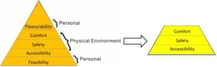
Walking needs hierarchy was developed by Alfonzo in 2015 and consist by 5 factors. In this study, specifically three main factors from walking need hierarchy were selected based on the physical environment factor, namely comfortability factor, safety factor, and accessibility factor to be evaluated on the assessment tool (figure 2)
Figure 2. Walking Needs Hierarchy (left) and Selected Specific Factors (right).
3.2 Deciding the Wight of Points for the Evaluation Tool based on Questionnaire answer.
Figure 3. Answers of the question “In your opinion, what is the most important factor that sidewalk in Indonesia should
have?”
To decide the weight points for the evaluation tool, spreading questionnaire used as methodology. 7 questions were included in the questionnaire. One of the questions is to decided which factor from 3 selected factors above (safety, comfortability, and accessibility) is the most important for people Indonesia in terms of their sidewalk.
Table 2. Assessment Tool Scoring Development
Based on the answers on figure 3, this evaluation tool used the answers to give the weight of the points for the evaluation tool. Safety
36%
Accessibility 27% Comfortab
11-3
the weight point for the evaluation tool are 37 maximum points for comfortability, 36 maximum points for safety, and 27 points for accessibility. All these 3 factors have 2 developed criteria namely sidewalk existence, sidewalk surface condition, shading, lightning, obstacles, and curb ramp on the intersection. The details were shown on the table 2.
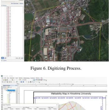
3.3 Developing Database by Street Assessment and Digitizing Process
In this part, ever segments of street in study area were assessed using criteria in table 2. After street were assessed, the segments the digitized by Google Map software. The process shown in figure 4.
Figure 4. Illustration of street assessment process.
Process of assessment and digitizing on were done on the same time. Right after one segment evaluated, the segment then digitized on Google Earth. All segments then given the number as its ID based on the order the streets were evaluated.
Figure 5. Street Assessment Process
After the segments were digitized, the file then exported to ArcGIS, which has more features to showing the information on every street. The information was a combination of digitized file on the Google Earth and street values from the evaluation tool. Values could be shown on the map, the greener the color of the street contains high value of
walkability. On the other hand, the closer the street color to red, the value of walkability on its street are low.
Figure 6. Digitizing Process.
Figure 7. Data analyzed on ArcGIS
4. Mapping Result
After combining the value of street condition surface, existence of sidewalk, lightning, shading, obstacles on the sidewalk, and curb ramp condition from the assessment tool, the walkability map of campus and surrounding area in Indonesia and Japan were released. It could be seen clearly that walkability on surrounding area of Indonesian universities are lower than Japan (figure 8).
11-4
Figure 8. Walkability Map of Campus and Surrounding Area in Japan and Indonesia
5. Conclusions.
1. Related to the Pedestrian Catchment Area from university campus, the main gate of the campus has an important role. By increasing proper number of campus gate, the size of area that could accessed by walking could also increasing. In this study, it was revealed that all on going campus project, both in Indonesia and Japan, still have an area that not located in proper distance from university campus gate by walking. Moreover, another factor that making some areas on surrounding campus could not reached by 600 meters by walking because of terrain condition, such as river that exist such as in Gadjah Mada University and Sumatera Utara University.
2. This study revealed that people in Indonesia are putting more effort to comfortability (37%), followed by safety (36%) factor and accessibility factor (27%) for them to increase their willingness for walking towards proper walking distance. Based on this condition, author could develop a basic evaluation tool that could be used to evaluate the walking platform in Indonesia. However, there should be more deeply study that should be done to develop this
evaluation tool, especially in the comfortability (shading) issue since climate condition in the world are varied.
3. Walkability value of the streets inside campus area in Indonesia and Japan were high. However, the walkability value dramatically decreased on surrounding campus area in Indonesia. This should get more attention from government and university to find a solution to creating better the walking environment especially on surrounding campus area to increasing the willingness for students that live on surrounding campus area to walking and reduce the usage of motorized vehicle.
References
Aizawa, T., Helble, M. (2016). Socioeconomic Inequity in Excessive Weight in Indonesia. Asian Development Bank Institute Working Paper Series.
Althoff, T. Sosič, R. Hicks, J, L. King, A, C. Delp, S, L. & Leskovec, Jure. (2017). Large-scale Physical Activity Data Reveal Worldwide Activity Inequality. Nature, 547. pp 336-339.