ArcGIS Runtime SDK for WPF
ター
ッ
v10.2.5
目次
めに ... 1
ー い ... 1
ArcGIS Runtime SDK for WPF ... 1
ArcGIS Runtime SDK for WPF 開発環境 ... 2
ArcGIS Runtime SDK for WPF ン ... 3
ッ GIS ー ョン 開発 ... 4
API ン ー ... 4
GIS ー ン 開発 ... 5
作成 Basic/Standard ン 共通 ... 6
API 参照 追加 Basic/Standard ン 共通 ... 7
Map ン ー 追加 Basic/Standard ン 共通 ... 8
ッ GIS ー ョン 配布 ... 38
GIS ー ン 配布 概要 ... 38
ArcGIS Runtime 配布用 作成 ... 40
ン ー 追加 Standard 配布 ン ... 47
配布用 ン ... 49
ArcGIS Runtime 追加機能 ン ... 50
次 ... 52
ArcGIS Resources:ArcGIS Runtime SDK for WPF ... 52
ッ ... 58
Map ン ー Layers ... 58
種類 ... 59
ー ... 60
ー ... 63
他 ... 68
1
めに
ター
ッ
について
本 ー 初 ArcGIS Runtime SDK for WPF 使用 GIS
ー ン 構築 開発者 方 最 基本的 開発手順 流 紹介 本書 読
頂 ArcGIS Runtime SDK for WPF 使用 ー ン開発 基礎 理解
ArcGIS Runtime SDK for WPF
と
ArcGIS Runtime SDK for WPF GIS 機能 持 軽量 GIS ー
ン 開発 開発 開発 ー ン ArcGIS Runtime ArcGIS Runtime
SDK ン ー ン 配布 利用
ArcGIS Runtime SDK for WPF 詳細 下記 参照 い
ArcGIS Runtime SDK for WPF:
2
ArcGIS Runtime SDK for WPF
開発環境
ArcGIS Runtime SDK for WPF 用い WPF 対応 GIS ー ン
開発
本 Microsoft Visual Studio ArcGIS Runtime SDK 10.x for WPF 用い
GIS ー ン 開発手順 紹介 本 手順 実行 前 以下 環境 使用
ン 適切 い 必要 あ
開発環境:
サ ー る開発環境 IDE
Microsoft Visual Studio 2010 SP1 Microsoft Visual Studio 2012
Microsoft Visual Studio 2013 ArcGIS Runtime SDK 10.2 for WPF 以上 ー
SDK 要件
Microsoft .NET Framework 4.0 以上
Microsoft XML ー MSXML 6.0
ArcGIS for Desktop ※ ッ パッ ー 作成に使用 :
ArcGIS Runtime SDK 10.2.5 for WPF 使用 場合:
ArcGIS 10.2 for Desktop 以上 ー ン 最新 ー ン 推奨
ArcGIS Runtime SDK 10.x for WPF ー 最新 動作環境 下記 参照
い
ArcGIS Runtime SDK for WPF 動作環境:
3
ArcGIS Runtime SDK for WPF
セン
ArcGIS Runtime SDK ン い 下記 参照 い
セン :
4
ッ
GIS
ー ョン 開発
API
ン
ー
ArcGIS Runtime SDK for WPF 用い WPF 対応 GIS ー
ン 開発 API 入手 必要 あ API ン ー 方法
い 以下 URL ArcGIS Runtime SDK for WPF ン ー 参
照 い
ArcGIS Runtime SDK for WPF ン ー ー ン 10.2.5 版
5
ッ
GIS
ー ョン 開発
以下 手順 Visual Studio 2012 用い ArcGIS Runtime SDK for WPF ン ー 時 提供 ン ー ー ン 名称:ArcGIS Runtime SDK 10.x for WPF Application 使
用 GIS ー ン ン 作成
本 ー 下記 設定 ー ン 作成
※ Visual Studio 2010 や Visual Studio 2013 用い 場合 GIS ー ン
作成手順 同様
※ Visual Studio 2013 ArcGIS Runtime SDK 10.2 for WPF 以上 ー
.NET Framework ー ン:4.5
ー ン ン 言語:C#
ー び配布用 ー ン 格納用
格納 任意 必要 応 新規 作成 自身 環境 合わ
置 換え 本 ー 読 い
C:\workspace\project: 格納用
→ GIS ー ン 開発/配布 ン 使用
C:\workspace\data: ー 格納用
→ GIS ー ン 開発 ン 使用
C:\workspace\application:配布用 ー ン格納用
→ GIS ー ン 配布 ン 使用
10.2.5 前 ー ン 使用 場合 構成 格納先
日本語 含 い う 設定 10.2.5 前 ー ン
日本語 含 ー ン 実行 い既知 問題
6
ェ
作成
Basic/Standard
セン 共通
以下 手順 ArcGIS Runtime SDK 10.1.1 for WPF 例 い ArcGIS Runtime SDK 10.2.5
利用 場合 基本的 操作手順 同様
1. Visual Studio 2012 起動 [ ] → [新規作成] 選択 [ ]
2. [新 い ] [ ン ー ] ン [Visual C#] →
[Windows] → [ArcGIS] 選び [ArcGIS Runtime SDK 10.x for WPF Application] 選
択 作成場所 事前 作成 C:\workspace\project\
変更 [OK] ン
本 名前 びソ ー ン名 ArcGISWpfApplicationSample
7
3. 新 い WPF ー ン 含 ソ ー ン 作成
API
参照 追加
Basic/Standard
セン 共通
以下 ン ー ー ン作成時 予 追加 API い 解説
1. ArcGIS Runtime SDK for WPF 参照設定 確認 ソ ー ン
ー [参照設定] 展開
2. ン ー ー ン ESRI.ArcGIS.Client び
ESRI.ArcGIS.Client.Local ン 追加 い
※API 設定 以下 ン ー い
C:\Program Files (x86)\ArcGIS SDKs\WPF10.x\sdk\bin
2 ン 含 API WPF ー ン上 ArcGIS
for Server や ArcGIS Online 提供 Web GIS ー ー や ArcGIS for
Desktop 使用 作成 ー ー ー ,
8
Map
コン
ー
追加
Basic/Standard
セン 共通
以下 ン ー ー ン 予 追加 い 地図 表示 Map ン
ー び Map ン ー 追加 い 各種 い 解説
1. MainWindow.xaml [XAML] ー 開
ン ー ー ン Map ン ー び Map ン ー
7 ン 状態 追加 い
<Window x:Class="ArcGISWpfApplicationSample.MainWindow"
xmlns="http://schemas.microsoft.com/winfx/2006/xaml/presentation"
xmlns:x="http://schemas.microsoft.com/winfx/2006/xaml"
xmlns:esri="http://schemas.esri.com/arcgis/client/2009"
Title="MainWindow" Height="350" Width="525">
<Grid>
<esri:Map x:Name="_map" UseAcceleratedDisplay="False"> <!-- ArcGIS Online Tiled Basemap Layer -->
<!--<esri:ArcGISTiledMapServiceLayer ID="World Topo Map" Url="http://services.arcgisonline.com/ArcGIS/rest/ services/World_Topo_Map/MapServer"/>-->
<!-- Local Tiled Basemap Layer -->
<!--<esri:ArcGISLocalTiledLayer ID="Topographic USA" Path="C:¥Program Files (x86)¥ArcGIS SDKs¥
WPF10.1.1¥SDK¥Samples¥Data¥TPKs¥Topographic.tpk"/>-->
<!-- ArcGIS Online Dynamic Map Service Layer -->
<!--<esri:ArcGISDynamicMapServiceLayer ID="USA Demographic"
Url="http://services.arcgisonline.com/ArcGIS/rest/ services/Demographics/USA_Recent_Population_Change/ MapServer"/>-->
<!--Local Dynamic Layer-->
<!--<esri:ArcGISLocalDynamicMapServiceLayer ID="USA" Path="C:¥Program Files (x86)¥ArcGIS SDKs¥
WPF10.1.1¥SDK¥Samples¥Data¥MPKs¥USCitiesStates.mpk"/>-->
<!-- Online Editable FeatureLayer -->
<!--<esri:FeatureLayer ID="Fire Incidents"
Url="http://sampleserver3.arcgisonline.com/ArcGIS/rest/ services/Fire/Sheep/FeatureServer/0"
/>-->
<!--Local Feature Layer-->
9
WPF10.1.1¥SDK¥Samples¥Data¥MPKs¥USCitiesStates.mpk" LayerName="States"/>-->
<!--Graphics Layer-->
<!--<esri:GraphicsLayer ID="Example Graphic">
<esri:Graphic>
<esri:Graphic.Symbol>
<esri:SimpleMarkerSymbol Style="Circle" Color="Red"/>
</esri:Graphic.Symbol>
<esri:Graphic.Geometry>
<esri:MapPoint X="0" Y="0" >
<esri:MapPoint.SpatialReference>
<esri:SpatialReference WKID="102100"/>
</esri:MapPoint.SpatialReference>
</esri:MapPoint>
</esri:Graphic.Geometry>
</esri:Graphic>
</esri:GraphicsLayer>-->
</esri:Map> </Grid>
10
上記 ー 行 4 xmlns:esri=http://… い esri いう名称 API
参照 宣言 い esri いう名前空間 API
内 ン ー 参照 う
API 内 Map ン ー esri:Map いう形式 参照 ー 内 追
加 い Map ン ー Name _map MyMap
いう値 指定 Map ン ー 以下 7 種類 ン
状態 追加 い
開発 び評価目的 場合 種類 利用可能 開発 ー
ン 配布 際 ArcGIS Runtime SDK for WPF ン Basic 場合
一部 種類 利用
ArcGIS Online Tiled Basemap Layer ArcGISTiledMapServiceLayer :Basic/Standard ン 共通
ArcGIS for Server ArcGIS Online ー ー ソ
ー 使用
Local Tiled Basemap Layer ArcGISLocalTiledLayer :Basic/Standard ン 共通
ArcGIS for Desktop 作成 ー ー ソー 使用
ArcGIS Online Dynamic Map Service Layer ArcGISDynamicMapServiceLayer :Basic/Standard ン 共通
ArcGIS for Server ArcGIS Online ー ー
ソー 使用
Local Dynamic Layer ArcGISLocalDynamicMapServiceLayer :Standard ン
ArcGIS for Desktop 作成 ー ー ソー 使用
Online Editable FeatureLayer FeatureLayer :Basic/Standard ン 共通
ArcGIS for Server ArcGIS Online ー ー ー ソー
11 Local Feature Layer ArcGISLocalFeatureLayer
:Standard ン
ArcGIS for Desktop 作成 ー 内 1 ー ソー
使用
Graphics Layer GraphicsLayer :Basic/Standard ン 共通
上 図形描画や地物検索 ー ン 生成 図形情
報 ー ソー 使用
本 Map ン ー 追加 7 種類 内 ArcGIS Online Tiled
Basemap Layer ArcGISTiledMapServiceLayer ArcGIS Online Dynamic Map Service
Layer ArcGISDynamicMapServiceLayer Local Tiled Basemap Layer
ArcGISLocalTiledLayer Local Dynamic Layer ArcGISDynamicMapServiceLayer
12
GIS サー 追加
ArcGIS Online Tiled Basemap Layer:ArcGISTiledMapServiceLayer
:Basic/Standard セン 共通
以下 ArcGIS Online World Topo Map いう ID ー 背景地図
Map ン ー 追加 手順 説明
※ ン ン ー 参照 ン ーネ 接続 い 必要 あ
1. MainWindow.xaml [XAML] ー い <!-- ArcGIS Online Tiled Basemap Layer --> 以下 行 9 – 10 選択 ン 解除
<esri:Map x:Name="_map" UseAcceleratedDisplay="False"> <!-- ArcGIS Online Tiled Basemap Layer -->
<esri:ArcGISTiledMapServiceLayer ID="World Topo Map" Url="http://services.arcgisonline.com/ArcGIS/rest/ services/World_Topo_Map/MapServer"/>
・・・
</esri:Map>
Map ン ー ArcGIS Online World Topo Map いう ID
ー 追加 状態
2. 実行 Visual Studio 2012 ー [ ] 選択
13
3. 実行 開始 WPF ー ン 起動
時点 や ー 地図 ー ン操作 可能
WPF ー ン 正常 実行 い 確認 ー ン 閉
14
GIS サー 追加
ArcGIS Online Dynamic Map Service Layer:ArcGISDynamicMapServiceLayer
:Basic/Standard セン 共通
以下 XAML ー ン ン ArcGIS Online World Topo Map
いう ID ー 背景地図 上 ArcGIS Online
ー 重 合わ 手順 説明
※ ン ン ー 参照 ン ーネ 接続 い 必要 あ
※ 本 米国 Esri 社 ー ー 使用 い ー び ー
米国 Esri 社 管理 表示 地図 内 画像 異 場合 あ 操作
手順 違い あ
XAML
ー ン C# : ン
[XAML] ー ArcGIS Online World Topo Map いう ID ー
背景地図 上 ArcGIS Online ー 重 合わ 手順 説明
1. MainWindow.xaml [XAML] ー い
<!-- ArcGIS Online Dynamic Map Service Layer --> 以下 行 16 – 17 選択
15 <esri:Map x:Name="_map" UseAcceleratedDisplay="False">
<!-- ArcGIS Online Tiled Basemap Layer -->
<esri:ArcGISTiledMapServiceLayer ID="World Topo Map" Url="http://services.arcgisonline.com/ArcGIS/rest/ services/World_Topo_Map/MapServer"/>
<!-- Local Tiled Basemap Layer -->
<!--<esri:ArcGISLocalTiledLayer ID="Topographic USA" Path="C:¥Program Files (x86)¥ArcGIS SDKs¥
WPF10.1.1¥SDK¥Samples¥Data¥TPKs¥Topographic.tpk"/>-->
<!-- ArcGIS Online Dynamic Map Service Layer -->
<esri:ArcGISDynamicMapServiceLayer ID="USA Demographic" Url="http://services.arcgisonline.com/ArcGIS/rest/ services/Demographics/USA_Recent_Population_Change/ MapServer"/>
・・・
</esri:Map>
ArcGIS Online World Topo Map いう ID ー 背景地図
上 ArcGIS Online USA Demographic いう ID ー
追加 状態
2. 実行 Visual Studio 2012 ー [ ] 選択
[ 開始]
16
周辺 拡大 上記 追加 ー
地図上 表示
WPF ー ン 正常 実行 い 確認 ー ン 閉
Visual Studio 停止
17 ョン
ー ン C# ArcGIS Online World Topo Map いう ID
ー 背景地図 上 ArcGIS Online ー 重 合わ 手順 説明
XAML ー 追加 い 場合 MainWindow.xaml
行 16 – 17 再び ン い
1. MainWindow.xaml ー ン MainWindow.xaml.cs 開
2. 名前空間 ESRI.ArcGIS.Client 参照 追加 い 確認
using ESRI.ArcGIS.Client;
3. ン 以下 ー 追加
using ESRI.ArcGIS.Client;
namespace ArcGISWpfApplicationSample
{
public partial class MainWindow : Window
{
public MainWindow()
{
// License setting and ArcGIS Runtime initialization is done in Application.xaml.cs.
InitializeComponent();
ArcGISDynamicMapServiceLayer arcgisDynamicMapServiceLayer = new ArcGISDynamicMapServiceLayer();
18
4. 実行 Visual Studio 2012 ー [ ] 選択
[ 開始]
5. 実行 開始 WPF ー ン 起動
周辺 拡大 上記 追加 ー
地図上 表示
WPF ー ン 正常 実行 い 確認 ー ン 閉
Visual Studio 停止
19
ー ータ 追加
Local Tiled Basemap Layer:ArcGISLocalTiledLayer
:Basic/Standard セン 共通
以下 ArcGIS Runtime SDK for WPF ン ー 時 提供 Topographic USA いう ID
ン ー Map ン ー 追加 手順 説明
1. MainWindow.xaml [XAML] ー い GIS ー 追加 ン
解除 行 9 – 10 び行 16 – 17 ン 前 手順 い
ー ン ー 追加 場合
MainWindow.xaml.cs 追加 ー ン
2. <!-- Local Tiled Basemap Layer --> 以下 行 13 選択 ン 解除
<esri:Map x:Name="_map" UseAcceleratedDisplay="False"> <!-- ArcGIS Online Tiled Basemap Layer -->
<!--<esri:ArcGISTiledMapServiceLayer ID="World Topo Map" Url="http://services.arcgisonline.com/ArcGIS/rest/ services/World_Topo_Map/MapServer"/>-->
<!-- Local Tiled Basemap Layer -->
<esri:ArcGISLocalTiledLayer ID="Topographic USA" Path="C:¥Program Files (x86)¥ArcGIS SDKs¥
WPF10.1.1¥SDK¥Samples¥Data¥TPKs¥Topographic.tpk"/>
・・・
</esri:Map>
C:\Program Files (x86)\ArcGIS SDKs\WPF10.1.1\SDK\Samples\Data\TPKs 格納
Topographic いう名称 ー Topographic USA いう ID
20
ー ー ー ソー い ン環境 い 地
図 利用可能
※ 作成 GIS ー ン 配布 場合 ー
ー ー ArcGIS Runtime 格納 不整合 起
い う Path 変更 行 上 配布 必要 あ
3. 実行 Visual Studio 2012 ー [ ] 選択
[ 開始]
4. 実行 開始 WPF ー ン 起動
WPF ー ン 正常 実行 い 確認 ー ン 閉
21
ー ータ 追加
Local Dynamic Layer:ArcGISLocalDynamicMapServiceLayer
:Standard セン み
以下 XAML ー ン ン ArcGIS Runtime SDK for WPF ン
ー 時 提供 USA いう ID ン ー Map ン ー 追加
手順 説明
XAML
ー ン C# : ン
[XAML] ー Topographic USA いう ID ー 背景地図 上 ArcGIS
Runtime SDK for WPF ン ー 時 提供 USA いう ID ン ー
重 合わ 手順 説明
1. MainWindow.xaml [XAML] ー い <!--Local Dynamic Layer--> 以下 行 20
22 <esri:Map x:Name="_map" UseAcceleratedDisplay="False">
<!-- ArcGIS Online Tiled Basemap Layer -->
<!--<esri:ArcGISTiledMapServiceLayer ID="World Topo Map" Url="http://services.arcgisonline.com/ArcGIS/rest/ services/World_Topo_Map/MapServer"/>-->
<!-- Local Tiled Basemap Layer -->
<esri:ArcGISLocalTiledLayer ID="Topographic USA" Path="C:¥Program Files (x86)¥ArcGIS SDKs¥
WPF10.1.1¥SDK¥Samples¥Data¥TPKs¥Topographic.tpk"/>
<!-- ArcGIS Online Dynamic Map Service Layer -->
<!--<esri:ArcGISDynamicMapServiceLayer ID="USA Demographic" Url="http://services.arcgisonline.com/ArcGIS/rest/ services/Demographics/USA_Recent_Population_Change/ MapServer"/>-->
<!--Local Dynamic Layer-->
<esri:ArcGISLocalDynamicMapServiceLayer ID="USA" Path="C:¥Program Files (x86)¥ArcGIS SDKs¥
WPF10.1.1¥SDK¥Samples¥Data¥MPKs¥USCitiesStates.mpk"/>
・・・
</esri:Map>
Topographic USA いう ID ー 上 C:\Program Files
(x86)\ArcGIS SDKs\WPF10.1.1\SDK\Samples\Data\MPKs 格納
USCitiesStates いう名称 ー USA いう ID 追加 状態
ー ー ー ソー い ン環境 い 地
図 利用可能
※ 作成 GIS ー ン 配布 場合 ー
ー ー ArcGIS Runtime 格納 不整合 起
い う Path 変更 行 上 配布 必要 あ
2. 実行 Visual Studio 2012 ー [ ] 選択
23
3. 実行 開始 WPF ー ン 起動
周辺 拡大 上記 追加 ー 地図上 表示
WPF ー ン 正常 実行 い 確認 ー ン 閉
Visual Studio 停止
24 ョン
ー ン C# Topographic USA いう ID ー 背景地図 上
ArcGIS Runtime SDK for WPF ン ー 時 提供 USA いう ID ン
ー 重 合わ 手順 説明 XAML ン ー 追加
い 場合 MainWindow.xaml 行 20 再び ン
1. MainWindow.xaml ー ン MainWindow.xaml.cs 開
2. 名前空間 ESRI.ArcGIS.Client.Local 参照 追加
using ESRI.ArcGIS.Client.Local;
25 using ESRI.ArcGIS.Client;
using ESRI.ArcGIS.Client.Local;
namespace ArcGISWpfApplicationSample
{
public partial class MainWindow : Window
{
public MainWindow()
{
// License setting and ArcGIS Runtime initialization is done in Application.xaml.cs.
InitializeComponent();
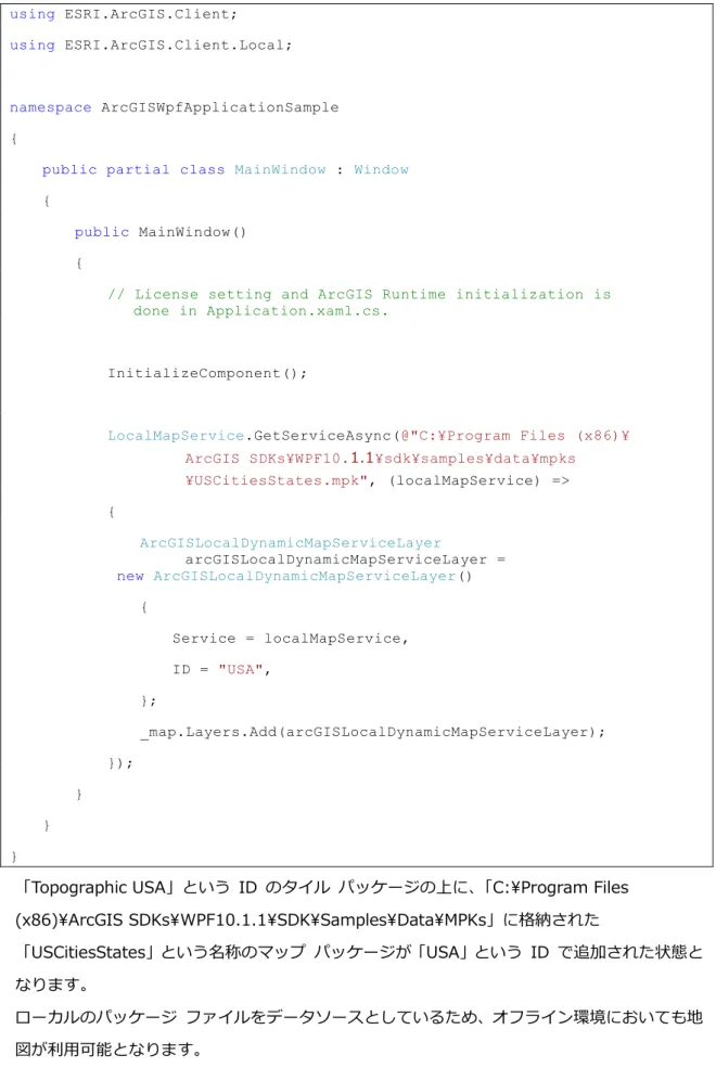
LocalMapService.GetServiceAsync(@"C:¥Program Files (x86)¥ ArcGIS SDKs¥WPF10.1.1¥sdk¥samples¥data¥mpks ¥USCitiesStates.mpk", (localMapService) => {
ArcGISLocalDynamicMapServiceLayer
arcGISLocalDynamicMapServiceLayer = new ArcGISLocalDynamicMapServiceLayer()
{
Service = localMapService,
ID = "USA", }; _map.Layers.Add(arcGISLocalDynamicMapServiceLayer); }); } } }
Topographic USA いう ID ー 上 C:\Program Files
(x86)\ArcGIS SDKs\WPF10.1.1\SDK\Samples\Data\MPKs 格納
USCitiesStates いう名称 ー USA いう ID 追加 状態
ー ー ー ソー い ン環境 い 地
26
※ 作成 GIS ー ン 配布 場合 ー
ー ー ArcGIS Runtime 格納 不整合 起 い
う Path 変更 行 上 配布 必要 あ
4. 実行 Visual Studio 2012 ー [ ] 選択
[ 開始]
5. 実行 開始 WPF ー ン 起動
周辺 拡大 上記 追加 ー 地図上 表示
WPF ー ン 正常 実行 い 確認 ー ン 閉
Visual Studio 停止
27
ArcGIS for Desktop を使用 た独自 ー ータ 追加
Local Dynamic Layer:ArcGISLocalDynamicMapServiceLayer
:Standard セン み
ArcGIS 10.2 for Desktop 以上 ー ン ArcMap ー ン 使用 ESRI
ン 無償 提供 全国市区町村界 ー ー ー 作成
WPF ー ン Map ン ー 追加 手順 説明
1. 以下 ESRI ン Web ー
http://www.esrij.com/products/data/japan-shp/
2. ー 右 [ ン ー ] ン 全国市区町村界 ー
28
3. ン ー Japan_ver72.zip 任意 解凍
本 事前 作成済 C:\workspace\data 解凍 ー 配置
4. Windows [ ー ] → [ ] → [ArcGIS] → [ArcMap 10.x] ArcMap 起動
29
6. [ 接続] ー 配置 C:\workspace\data
[OK]
7. ン [ 接続] 下 追加 ー
japan_ver72.shp & ー ー 追加
※ ArcMap ー 追加 自動的 ン 配色 設定 下記 画像
ン 異 場合 あ
8. ン や 変更 本 事前 作成 い
30
9. ArcMap ー ー [ ] → [ArcMap ン] 選択
31
11. [ ー ] ン [ArcGIS Runtime ー 有効化] 入 [OK]
ン
12. ArcMap ー ー [ ] → [共有] → [ ー ] 選択
32
14. 左側 [ ー ] ン 選択 い 確認 右側 [ ー
保存] ン 入 ー 保存先 事前 作成 い
C:\workspace\data 指定 ー 名称 japan_ver72
[ArcGIS Runtime ー ] 入 い 確認 他
設定
15. 左側 [ 説明] ン 選択 [ 必須 :] び [ 必須 :] [説
明] 以下 内容 入力
必須 :全国市区町村界 ー
必須 :日本
33
16. [ ー ] 右上 [分析] ン 分析 行う
ー ン ネ や ー い い 検知
※ 環境 ArcMap ー ン 動作 停止 いう 表
示 ArcMap 異常終了 場合 あ 場合 以下 URL 参照
い
https://esrij-esri-support.custhelp.com/app/answers/detail/a_id/4011
Esri 製品 ー ン 必要
17. ArcMap [準備] ン ー い 確認 [ ー ]
[共有] ン
34
19. ー 作成 開始 ー 作成 [完了]
表示 ー 正常 作成 確認 [OK] ン
35 21.
C:\workspace\project\ArcGISWpfApplicationSample\ArcGISWpfApplicationSample\
bin\Debug mpks いう名前 作成 上記 作成 ー
japan_ver72.mpk ー
22. Visual Studio MainWindow.xaml [XAML] ー 開
23. [XAML] ー い ー ー 追加 ン 解除 行 13
び行 20 ン ー ン ー 追加 場合
MainWindow.xaml.cs 追加 ー ン
24. [XAML] ー 行 21 下記 ー 追加
36 <esri:Map x:Name="_map" UseAcceleratedDisplay="False">
<!-- ArcGIS Online Tiled Basemap Layer -->
<!--<esri:ArcGISTiledMapServiceLayer ID="World Topo Map" Url="http://services.arcgisonline.com/ArcGIS/rest/ services/World_Topo_Map/MapServer"/>-->
<!-- Local Tiled Basemap Layer -->
<!--<esri:ArcGISLocalTiledLayer ID="Topographic USA" Path="C:¥Program Files (x86)¥ArcGIS SDKs¥
WPF10.1.1¥SDK¥Samples¥Data¥TPKs¥Topographic.tpk"/>-->
<!-- ArcGIS Online Dynamic Map Service Layer -->
<!--<esri:ArcGISDynamicMapServiceLayer ID="USA Demographic" Url="http://services.arcgisonline.com/ArcGIS/rest/ services/Demographics/USA_Recent_Population_Change/ MapServer"/>-->
<!--Local Dynamic Layer-->
<!--<esri:ArcGISLocalDynamicMapServiceLayer ID="USA" Path="C:¥Program Files (x86)¥ArcGIS SDKs¥
WPF10.1.1¥SDK¥Samples¥Data¥MPKs¥USCitiesStates.mpk"/>-->
<esri:ArcGISLocalDynamicMapServiceLayer ID="Japan"
Path="mpks¥japan_ver72.mpk" />
・・・
</esri:Map>
Map ン ー 作成 WPF ー ン 基準 相対 mpks
格納 japan_ver72 いう名前 ー Japan いう ID
追加 状態
GIS ー ン 参照 ー ー ー
ン 一緒 配布 場合 例 う ー ン 基準 ー ー
相対 内 使用 ー ン ー ー 構造
維持 配布 実行 環境 変わ ー ン ー ー
正 参照
25. 実行 Visual Studio 2012 ー [ ] 選択
37
26. 実行 開始 WPF ー ン 起動
上記 作成 日本 ー 地図上 表示
WPF ー ン 正常 実行 い 確認 ー ン 閉
Visual Studio 停止
以上 ン ー ン 開発 終了 作成 WPF ー ン 配布方法 い
GIS ー ン 配布 参照 い
高度 ー ン 開発 関 参考 ン や ン 詳細 い 次
38
ッ
GIS
ー ョン 配布
ッ
GIS
ー ョン 配布 概要
ArcGIS Runtime SDK for WPF 開発 び評価 無償 行う 開発 ー
ン 運用環境 配布 Basic Standard ン 必要
各 ン 配布 概要 以下 通
Basic ン
Basic ン 無償 ン ArcGIS Runtime ー ン 配布
う 構成 運用環境 ー ン 実行
Standard ン
Standard ン 場合 ー ン ン ー 使用 認証 上
ArcGIS Runtime ー ン 配布 う 構成 必要 あ
Standard ン 使用 運用環境 配布 場合 別途 有償 ン 購入
必要 あ
ン ン ン
Standard ン 以下 3 種類 ン ン ン 追
加 高度 ン ー 実行
Spatial Analyst: ー 空間 ン び解析
3D Analyst:3 次元 ー 解析
Network Analyst:道路交通網 ネ ワー 解析
Standard ン び ン ン ン 購入 希望 場合
問い合わ い
ン ー 追加方法 い 参照 い
ArcGIS Runtime SDK ン び配布条件 詳細 い 下記 参照 い
セン
39
本 作成 ン GIS ー ン ー ー 使
用 い 運用環境 ー ン 配布 Standard ン ー ン
適用 必要 あ
以下 GIS ー ン 開発 作成 WPF ー ン ArcGIS
40
ArcGIS Runtime
配布用
作成
配布用 ー 使用 ー ン 配布先 環境 実行 必要 作
成
1. Windows [ ー ] → [ ] → [ArcGIS] → [Runtime SDK 10.x for WPF] → [Runtime Tools] [ArcGIS Runtime WPF Deployment Builder 10.x] 選択
1. [ArcGIS Runtime Deployment Builder] 起動 2. [Create Configuration...] ン 選択
3. Name: ー 任意 名前 設定 [OK]
41
4. [Create Deployment Configuration] 各設定項目 以下 通 設定
[Select Optional Functionality] 指定 種類 い ArcGIS Runtime 追
加機能 ン 参照 い
Platform:Windows 64 Bit 64 bit ー ン 場合 Select Optional Functionality:
Local Server
Additional Data Formats Vector
42
6. [ArcGIS Runtime Deployment Builder] [Generate] 構成 格納
先 事前 作成 C:\workspace\application 指定
構成 格納先 日本語 含 い う 設定 日本語
含 場合 ー ン 実行 い既知 問題 あ
C:\Users\< ー 名>\Documents\ArcGIS\Runtime
Deployments\ 構成 格納
7. [OK]
43
9. 構成 作成 開始
10. 構成 作成 完了 び構成先 開 う 示 表示
44
45
12. 手順11 作成 一 上 階層
C:\workspace\application\SampleApplication1.0
GIS ー ン 時 作成
C:\workspace\project\ArcGISWpfApplicationSample\ArcGISWpfApplicationSample\
bin\Debug 以下 び ー
mpks
ArcGISWpfApplicationSample.exe ESRI.ArcGIS.Client.dll
ESRI.ArcGIS.Client.Local.dll
ー元:
C:\workspace\project\ArcGISWpfApplicationSample\ArcGISWpfApplicationSample\bi
46
※ 本 作成 以外 ー ー ー / ー
ー ン 参照 い 場合 ー ン内 適切 変更 上
再度 行い ー ン 参照 ー ー 配布用
配置 必要 あ
※ 本 使用 い ー 使用 場合
自身 環境 合わ 置 換え い
ー ン 配布 際 必要 ン 詳細 い 配布用
ン 参照 い
ー先:C:\workspace\application\SampleApplication1.0
13. ArcGISWpfApplicationSample.exe ー ン 正常 起動
確認
※ Standard 配布 ン 必要 機能 使用 い Standard 配布 ン
ン ー 追加 い い場合 ー ン起動時 目的
実行 い 示 表示
以上 GIS ー ン 配布手順 説明 終了 上記 作成
C:\workspace\application 配布先 環境 ー ー ン 実行
47
セン
コー
追加
Standard
配布
セン
以下 ー ン Standard 配布 ン ン ー 追加 手順 紹介
1. WPF ー ン 開発 ン 作成 ソ ー ン 内
Application.xaml.cs 開
2. 行 18 – 20 Before initializing the ArcGIS Runtime first・・・obtained from the License
Viewer tool. 下 ン ー 設定
// Before initializing the ArcGIS Runtime first
// set the ArcGIS Runtime license by providing the license string
// obtained from the License Viewer tool.
ArcGISRuntime.SetLicense("runtimestandard,101,rus123456789, 31-dec-2014,1A23BCDEFG4IJ5KLM678");
3. 実行 Visual Studio 2012 ー [ ] 選択
[ 開始]
48 5. ArcGIS Runtime 配布用 作成 手順 従 ー ン 配布先 環
49
配布用
ン
以下 ー ン 配布 際 必要 ン い 説明
主要 ン 用
名 説明
ESRI.ArcGIS.Client.dll べて ー ョンに必須
や ArcGIS for Server GIS ー
Query, Find, Identify や ン 使用
ン ーネン
ESRI.ArcGIS.Client.Local.dll ー サー を使用 た
べて ー ョンに必須
ー ー ー ン
ー 使用 ン ―ネン
追加 ン 用
名 説明
ESRI.ArcGIS.Client.Behaviors.dll XAML や ン 利用
ン ーネン
ESRI.ArcGIS.Client.Bing.dll Microsoft 社 Bing Maps 利用 ン ー
ネン
ESRI.ArcGIS.Client.Printing.dll ArcGIS 10.x for Server ン ー 時 構成済 PrintingTools ExportWebMap ー
ン ーネン
ESRI.ArcGIS.Client.Toolkit.dll Navigation ン ー や MapTips ン ー
対話的 操作 ン ー
含 ン ーネン
ESRI.ArcGIS.Client.Toolkit.
DataSources.dll
OpenStreetMap や WMS 一般的 ー ソー
ー ン ーネン
ESRI.ArcGIS.Client.Portal.dll WebMap ン ン び ー 読 取 処
50
ArcGIS Runtime
追加機能
ョン
以下 [ArcGIS Runtime WPF Deployment Builder] ArcGIS Runtime 配布用 作成 際 [Select Optional Functionality] 指定 ArcGIS Runtime 追加機能 ン
い 説明
ョン 説明
・Local Server ー ー 使用
・Geocoding ー ー 使用 ー ー
ン
・Geoprocessing ン ー 使用 ー
ン
・Spatial Analyst Spatial Analyst 機能 含 ン
ー 使用 ー ン
・3D Analyst 3D Analyst 機能 含 ン ー
使用 ー ン
・Network Analyst Network Analyst 機能 含 ン
ー 使用 ー ン
・Map Server Results ン 結果 ー 表示
・Python Scripting Python 使用
・Python Geoprocessing tools Python 使用 ン ー
・Python PDF output support Python 使用 PDF 出力
・Additional Data Formats 追加 ー ー
・Vector ー 追加 形式 ー
・Raster 追加 形式 ー
ー い Supported
raster types 参照 い
・Mosaic Rasters
・ECW Rasters ECW ー
・SDE ン ー ー ー DB2, Informix,
Oracle, SQL Server ー ソー ー
ー ・Additioonal Projection
Engine Transformations
追加 投影や座標系 利用
51
参照 い
・Advanced Symbology※1 複雑 ン ン 使用 高度 ン ー
※ ・Military Message Processing (MIL2525C)
MIL-STD-2525C ー ン
使用 ー ー 表示や ン ン
・Military Message Processing (App6B) App6B ン 使用
ー ー 表示や ン ン
・S57 Hydrographic Symbology S57 ン 使用 S57 ー 表示
52
次
ッ
本 ー ArcGIS Runtime SDK for WPF 用い GIS ー
ン 開発 最 基本的 開発手順 い 紹介 高度 ー ン 開発
ArcGIS Resources 参照 い ArcGIS Resources API 使用 開発
参考 ン や ン 集約 い
ArcGIS Resources
:
ArcGIS Runtime SDK for WPF
Home
http://resources.arcgis.com/en/communities/runtime-wpf/
ArcGIS Resources ArcGIS Runtime SDK for WPF ー ー 製品 最新 情報 確
53 Samples
http://resources.arcgis.com/en/help/runtime-wpf/samples/index.html
ArcGIS Runtime SDK for WPF 用い ン ー ン 開発 ー 使用 い
ー ン ー ン ー ン ArcGIS Runtime SDK for WPF
ン ー 時 設定 下記 ン ー
C:\Program Files (x86)\ArcGIS SDKs\WPF10.x\sdk\samples
ン ー ン ー ン Windows [ ー ] → [ ]
→ [ArcGIS] > [Runtime SDK 10.x for WPF] > [ArcGIS Runtime WPF Samples 10.x]
ArcGIS Runtime SDK for WPF 使用 ー ン 開発 場合 ン
54 Concepts
http://resources.arcgis.com/en/help/runtime-wpf/concepts/index.html
ArcGIS Runtime SDK for WPF 概要や各種開発方法 地図 追加や ー ー や ン ン ー
55 API Reference
http://resources.arcgis.com/en/help/runtime-wpf/apiref/index.html
56 Forums
https://geonet.esri.com/community/developers/native-app-developers/arcgis-runtime-sdk-for-wpf
57 Gallery
http://www.arcgis.com/home/group.html?owner=eric906&title=ArcGIS%20Runtime%20SDK%20for%
20WPF&content=all
Esri 開発者や全世界 開発者 方 作成 ー ン 紹介 ー ー
58
ッ
Map
コン
ー
Layers
パ
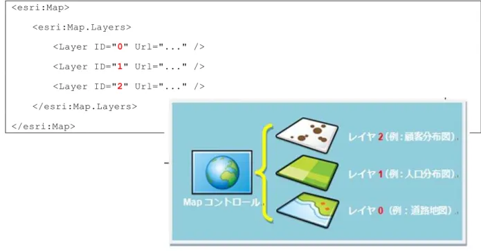
ArcGIS Runtime SDK for WPF 使用 作成 ー ン 地図 表示 Map
ン ー 通常 1 以上追加 Map ン ー ー ン上 表示 地図
範囲 縮尺 座標系 情報 保持 1 以上 顧客分布図 主題図や道路地
図 背景地図 追加
<esri:Map>
<esri:Map.Layers>
<Layer ID="0" Url="..." />
<Layer ID="1" Url="..." />
<Layer ID="2" Url="..." />
</esri:Map.Layers>
</esri:Map>
上記 例 う Map ン ー Layers 複数 追加 可能 あ
Map ン ー 最初 追加 上記 例 0 層 最 下 表示
59
種類
Map ン ー 追加 ー ソー 違い ー
ー 2 種類 分
ー ソー ArcGIS for Server や ArcGIS Online ン ン ー
ン ー ー 使用
ー や ー 解析 ー GIS ン ン 単一 ー 圧縮
ネ ワー 接続 い環境 ー ー 配置
ー ン 実行
ー ー ソー 多 複数 構成 あ
ー や ー 内 う ン や色 使用 地図上 表示 定義
い Map ン ー 定義 従い ー 上 ー 場合 ン ー
ー 上 生成 地図画像 表示
ー ー ン上 動的 ン や色 設定 特定 属性情報
ー 表示 設定 ー ー
ー 構成 複数 1 直接 内 地物 座標 び属
性情報 取得 ー ン上 動的 描画 行い
WPF ー ン 多 場合 い ン 情報等 変更 必要 い背景地図
ー 使用 ー 操作 応 表示 対話的 変更 必要 あ 主題図 ー
60
ッ
サー
ー ー ソー ArcGIS for Server 配信 い ー
ArcGIS for Desktop ArcMap ー ン 使用 作成 ー 指定
ー ArcGIS for Server REST 形式 公開 ー
REST ー ン ン ArcGIS for Server 生成
ー 画像 表示
ー ー ー ソー い 場合 ArcGIS Runtime ー
ー ー ン内 指定 ー 使用 ー 画像 生成
ー 画像 表示
ー ArcGIS for Server 配信 様々 ー や ー 対
応 以下 う ー 用意 い
ー :
サー ホ ッ サー 種類 説明
ArcGIS for Server
ArcGISTiledMapServiceLayer ArcGIS for Server ー
ー ソー 使用
ArcGISDynamicMapServiceLayer ArcGIS for Server ー
ー ソー 使用
ArcGISImageServiceLayer ArcGIS for Server ー ー
ー ソー 使用
ー ー
ArcGISLocalTiledLayer ArcGIS for Desktop 作成 ー
ー ソー 使用
ArcGISLocalDynamicMapServiceLayer ArcGIS for Desktop 作成 ー
61
ッ サー 指定
ArcGIS for Server ー ー 利用 場合 ー ソー
ー REST ン ン 指定 ArcGIS for Server ー REST
ン ン ArcGIS for Server ン ー ー 構成 ArcGIS Services
Directory 呼 簡易 Web ー ン 確認 以下 URL Esri
社 公開 い ArcGIS for Server ー REST ン ン 確認
ArcGIS Online:ArcGIS Services Directory
http://server.arcgisonline.com/arcgis/rest/services
Services: ン 表示 ー 一覧 使用 い ー 例え
62
World_Street_Map ー 詳細 表示 ー REST ン ン 表示
URL
※ ー ArcGIS for Server ArcGIS Services Directory Windows ー [ ] > [ArcGIS] > [ArcGIS 10.x for Server] > [Services Directory] 選択
パッ ー 指定
ー ー 利用 場合 WPF ー ン 実行 ン
PC 上 配置 ー 絶対 WPF ー ン 基準 ー
相対 指定
<esri:Map x:Name="MyMap">
<esri:ArcGISLocalDynamicMapServiceLayer
Path="..¥¥data¥¥mpks¥¥USCitiesStates_Lambert_Conformal_Conic.mpk"/>
63
ーチ
前述 通 ー ー 異 ー び ー
内 1 座標 属性情報 取得 ン 側 動的 描画 行い 以下 衛星
画像 Bing Maps) ー 上 ン ー 描画 例
ー 使用 上図 う 表現 加え 上 地物 動的
選択 編集 時間遷移 ー ン表現 実装 以下 ー
64
ッ サー 内 指定
ArcGIS for Server ー ー ソー ー 場合 ー
同様 ArcGIS for Server REST ー ー ソー 指定 ー
異 ー 内 個別 ー ソー 指定 以下 Esri 社
公開 い ン ー ー 個別 REST ン ン 確認
1. Esri ン ー 接続 [Specialty]
http://sampleserver1.arcgisonline.com/ArcGIS/rest/services/
65
3. ESRI_StatesCitiesRivers_USA ー 詳細 表示 ー
Cities (都市) Rivers 河川 States 州 3 含 い
わ [Cities]
4. Cities 詳細 表示 Cities ー REST ン ン 表
示 URL ー 使用 REST ン ン 異
66
5. 以下 例 上記手順 確認 Cities ArcGIS Online 世界道路地図 上 重
い ー FeatureLayer Url REST ン
ン 指定 い 他 FeatureLayer Where 使用 Cities
POP1990 列 値 100000 大 い ー 人口 10 万人 多い
取得 条件句 設定 い Where="POP1990 > 100000"
<esri:Map x:Name="MyMap">
<esri:ArcGISTiledMapServiceLayer ^
Url="http://services.arcgisonline.com:80/ArcGIS/rest/
services/World_Street_Map/MapServer" />
<esri:FeatureLayer ^
Url="http://sampleserver1.arcgisonline.com/ArcGIS/
rest/services/Specialty/ESRI_StatesCitiesRivers_USA/
MapServer/0"
Where="POP1990 > 100000"/>
</esri:Map>
6. FeatureLayer 他 ー ー 取得方式 設定 Mode
や 自動的 ン 集約 表示 ン 設定
Clusterer 用意 い 詳細 い API Reference 参照
67
パッ ー 内 指定
ー ー 利用 場合 ー 同様 ー
指定 ー 異 ー 内 個別 ー
ソー 指定 必要 あ ー 加え 名 LayerName
ID LayerID 指定
以下 Map ン ー 背景地図 Topographic.tpk ー 追加
上 USCitiesStates.mpk 内 Cities 追加 い 個別 指定
LayerName 設定 い 他 OutFields 使用 属性
ー 指定 下記 例 ー 取得 Cities 表示設定 定義
ン 設定 い 詳細 い API Reference 参照 い
<esri:Map x:Name="MyMap">
<esri:ArcGISLocalTiledLayer ID="TopoMapLayer" Path="..¥¥Data¥¥TPKs¥¥Topographic.tpk"/>
<esri:ArcGISLocalFeatureLayer ID="ArcGISLocalFeatureLayer"
Path="..¥¥Data¥¥MPKS¥¥USCitiesStates.mpk" LayerName="Cities" OutFields="*" Renderer="{StaticResource MySimplePointRenderer}">
68
そ 他
ArcGIS Runtime SDK for WPF ESRI.ArcGIS.Client.Toolkit.DataSources いう名前空間 使
用 Map ン ー 追加 拡張 あ 以下 主
紹介
HeatMapLayer
ン 密度 表現 可能 ー 表示 使用
顧客情報や交通事故情報 様々 情報 分布状況 効果的 視覚化
OpenStreetMapLayer
ー ン ー 表示 ー ン ー
地理情報 自由 共有 目的 誰 自由 利用・更新 世界的 地図作
69 GeoRssLayer
地震 発生 位置情報 含 定期的 更新情報 Geo RSS 動的 上 描画
WmsLayer / WmtsLayer
Open Geospatial Consortium (OGC) 策定 地図配信 標準 あ WMS (Web
Map Service) び WMTS Web Map Tile Service 地図上 表示
KmlLayer
70
拡張 い ー 同様 ー 重
合わ 使用 効果的 わ や い地図 ー ン 作成
拡張 い ン ー ン 公開 い
パッ ー
ArcGIS Runtime SDK for WPF ネ ワー 接続 い環境 WPF ー ン 実
行 ー 利用
※ ー WPF ー ン 使用 以外 ArcGIS Online 通 ー 共有
利用可能
ArcGIS Runtime SDK for WPF 扱う ー ー
ー ン ー ー ー 4 種類 あ ー ン 10.1 以降
ArcGIS for Desktop ArcMap ー ン 使用 作成
パッ ー 名 拡張子 説明
ー mpk ン .mxd ン 含 い
参照 い ー 含
ー tpk 含
ン
ー
gpk ン ー 正常 実行 結果 作成
単一 圧縮 解析機能や ン ワー ー
共有
71
ッ パッ ー
ー ン ン 含 い 参照 い
ー 含 Map ン ー 表示 ー ソー 指定
<esri:Map x:Name="MyMap">
<esri:ArcGISLocalDynamicMapServiceLayer
Path="..¥¥Data¥¥MPKS¥¥USCitiesStates_Lambert_Conformal_Conic.mpk"/>
</esri:Map>
72
タ パッ ー
ー 含 複数
縮尺 画像 生成 Map ン ー 表示 ー ソー
主 背景地図 静的 や更新 少 い 使用
大 ー 作成 場合 時間 非接続環境 情報量 多い
表示 適 い
ー 同様 Map ン ー 指定 利用
<esri:Map x:Name="_map" <esri:ArcGISLocalTiledLayer
Path="..¥¥Data¥¥TPKs¥¥Topographic.tpk"/>
</esri:Map>
73
セ ン パッ ー
ン ー ワー ーや解析 含 解析 実行 結
果 返 利用
ン ー 使用 解析 行う場合 解析結果 表示
や ン 等 設定 必要 あ
下記 ン ー ン 上 ン 描画 ン 指定 距離
作成 範囲 米国 郡 形状 ン 切 取 い
ン ー 作成 ArcMap ン 実行 必要 あ
実行結果 ン ー 作成 ン 作成
ー 作成 ン ー 使用 ー ン 作成方法 い 下
記 英語 参照 い
ン 作成方法 ン ー 作成
74
ータ パッ ー
ー ー 単一 ー ン ー 含 住所 位
置 特定 ー ン 位置 住所 特定 ー ー ン
利用
ン ー 同様 結果 表示 や ン 等 設定
必要 あ
下記 ン ー ン 上 位置 住所 座標値 表
示 い
ー ー 作成 ー ン ー 作成 必要 あ
ー / ン ー ArcCatalog 作成 作成方法 い 下記 参
照 い
住所 ー 作成
ン 住所 ー 作成
ArcGIS Runtime SDK for WPF
ター
ッ
v10.2.5
Visual Studio 2012
用
2015年2月27日
ESRI ン株式会社
http://www.esrij.com/
Copyright(C) Esri Japan. 無断転載 禁
本書 記載 い 社名 商品名 、各社 商標 び登録商標
本書 記載 い 内容 改良 予告 変更 場合 あ
本書 内容 参考情報 提供 目的 本書 含 情報 使用