独立行政法人
防災科学技術研究所
National Research Institute for Earth Science and Disaster Prevention
アジア防災科学技術情報基盤(DRH-Asia)コンテンツ集
防災科学技術研究所
Technical Note of the National Research Institute for Earth Science and Disaster Prevention No.350
December 2010
防災科学技術研究所研究資料 第
350号
アジア防災科学技術情報基盤(DRH-Asia)コンテンツ集
Collection of Technology and Knowledge Information
by the Disaster Reduction Hyperbase – Asian Application (DRH – Asia)
防災科学技術研究所研究資料 第三五〇号
防災科学技術研究所研究資料 防災科学技術研究所研究資料
第321号 平成17年度大都市大震災軽減化特別プロジェクト 実大6層RC建物実験報告書(付録CD-ROM)46pp.
2008年3月発行
第322号 地すべり地形分布図 第37集「福岡・中津」24葉(5万分の1).2008年8月発行 第323号 地すべり地形分布図 第38集「長崎・唐津」29葉(5万分の1).2008年9月発行 第324号 地すべり地形分布図 第39集「鹿児島」24葉(5万分の1).2008年11月発行 第325号 地すべり地形分布図 第40集「一関・石巻」19葉(5万分の1).2009年2月発行 第326号 新庄における気象と降積雪の観測(2007/08年冬期) 33pp.2008年12月発行 第327号 防災科学技術研究所45年のあゆみ(付録DVD) 224pp.2009年3月発行 第328号 地すべり地形分布図 第41集「盛岡」18葉(5万分の1).2009年3月発行 第329号 地すべり地形分布図 第42集「野辺地・八戸」24葉(5万分の1).2009年3月発行 第330号 地域リスクとローカルガバナンスに関する調査報告 53pp.2009年3月発行
第331号 E-Defenseを用いた実大RC橋脚(C1-1橋脚)震動破壊実験研究報告書-1970年代に建設された基部曲げ破壊タ イプのRC橋脚震動台実験-(付録DVD) 107pp.2009年1月発行
第332号 強震ネットワーク 強震データ Vol. 25(平成20年 No. 1)(CD-ROM版).2009年3月発行 第333号 強震ネットワーク 強震データ Vol. 26(平成20年 No. 2)(CD-ROM版).2009年3月発行
第334号 平成17年度大都市大震災軽減化特別プロジェクトⅡ 地盤基礎実験-震動台活用による構造物の耐震性向上研究-
(付録CD-ROM) 62pp.2009年10月発行
第335号 地すべり地形分布図 第43集「函館」14葉(5万分の1).2009年12月発行 第336号 全国地震動予測地図作成手法の検討(7分冊+CD-ROM版).2009年11月発行
第337号 強震動評価のための全国深部地盤構造モデル作成手法の検討(付録DVD).2009年12月発行 第338号 地すべり地形分布図 第44集「室蘭・久遠」21葉(5万分の1).2010年3月発行
第339号 地すべり地形分布図 第45集 「岩内」14葉(5万分の1).2010年3月発行 第340号 新庄における気象と降積雪の観測(2008/09年冬期) 33pp.2010年3月発行
第341号 強震ネットワーク 強震データ Vol. 27(平成21年 No. 1)(CD-ROM版).2010年3月発行 第342号 強震ネットワーク 強震データ Vol. 28(平成21年 No. 2)(CD-ROM版).2010年3月発行
第343号 阿寺断層系における深層ボーリング調査の概要と岩石物性試験結果(付録CD-ROM) 15pp.2010年3月発行 第344号 地すべり地形分布図 第46集 「札幌・苫小牧」19葉(5万分の1).2010年7月発行
第345号 地すべり地形分布図 第47集「夕張岳」16葉(5万分の1).2010年8月発行
第346号 長岡における積雪観測資料(31)(2006/07 , 2007/08 , 2008/09 冬期)47pp.2010年9月発行 第347号 地すべり地形分布図 第48集「羽幌・留萌」 17葉(5万分の1).2010年11月発行
第348号 平成18年度 大都市大震災軽減化特別プロジェクト実大3層RC建物実験報告書(付録DVD) 68pp.2010年8月発行 第349号 防災科学技術研究所による深層掘削調査の概要と岩石物性試験結果(足尾・新宮・牛伏寺)(付録CD-ROM)
12pp.2010年8月発行 第274号 強震ネットワーク 強震データ Vol. 18(平成16年 No. 3)(CD-ROM).2005年3月発行
第275号 全国を対象とした確率論的地震動予測地図作成手法の検討(付録CD-ROM 1枚) 393pp.2005年8月発行 第276号 シンポジウム「日本の地震観測の現状と将来展望」講演速記録集 90pp.2005年9月発行
第277号 地すべり地形分布図第24集「姫路」15葉(5万分の1).2005年11月発行 第278号 地すべり地形分布図第25集「松江・高梁」26葉(5万分の1).2005年12月発行 第279号 三陸沖北部の地震を想定した地震動予測地図作成手法の検討(CD-ROM).2005年9月発行 第280号 長岡における積雪観測資料(29)(2004年11月~2005年4月) 39pp.2005年11月発行
第281号 琵琶湖西岸断層帯の地震を想定した地震動予測地図作成手法の検討(CD-ROM).2005年10月発行 第282号 高山・大原断層帯の地震を想定した地震動予測地図作成手法の検討(CD-ROM).2005年11月発行 第283号 石狩低地東縁断層帯の地震を想定した地震動予測地図作成手法の検討(CD-ROM).2005年12月発行 第284号 地震ハザードステーションJ-SHIS DVD 2005年版(DVD).2005年12月発行
第285号 地すべり地形分布図第26集「浜田・大社」17葉(5万分の1).2006年1月発行 第286号 地すべり地形分布図第27集「広島」 16葉(5万分の1).2006年2月発行
第287号 強震ネットワーク 強震データ Vol. 19(平成17年 No. 1)(CD-ROM).2006年3月発行 第288号 強震ネットワーク 強震データ Vol. 20(平成17年 No. 2)(CD-ROM).2006年3月発行 第289号 新庄における気象と降積雪の観測( 2004 / 05年冬期) 41pp.2006年3月発行
第290号 地すべり地形分布図第28集「山口」21葉(5万分の1).2006年3月発行 第291号 地すべり地形分布図第29集「岡山及丸亀」15葉(5万分の1).2006年3月発行 第292号 日本の火山ハザードマップ集(付録DVD 2枚) 20pp.2006年3月発行
第293号 水害に対する住民の防災意識と防災行動等に関するアンケート調査資料集(CD-ROM).2006年3月発行 第294号 山崎断層帯の地震を想定した地震動予測地図作成手法の検討(CD-ROM).2006年3月発行
第295号 中央構造線断層帯(金剛山地東縁・和泉山脈南縁)の地震を想定した地震動予測地図作成手法の検討(CD-ROM). 2006年3月発行
第296号 日向灘の地震を想定した地震動予測地図作成手法の検討(CD-ROM).2006年3月発行 第297号 地すべり地形分布図第30集「徳島・剣山」23葉(5万分の1).2006年9月発行 第298号 神奈川県西部山北南高感度地震観測井の掘削および坑内検層 32pp.2006年10月発行 第299号 地すべり地形分布図第31集「高知・窪川」17葉(5万分の1).2007年3月発行 第300号 強震ネットワーク 強震データ Vol. 21(平成18年 No. 1)(CD-ROM).2007年3月発行 第301号 強震ネットワーク 強震データ Vol. 22(平成18年 No. 2)(CD-ROM).2007年3月発行 第302号 長岡における積雪観測資料(30)(2005. 11~2006. 3) 37pp.2007年3月発行
第303号 2003年十勝沖地震の観測記録を用いた強震動予測手法の検証(CD-ROM版).2007年3月発行 第304号 アジア・太平洋国際地震・火山観測網構築計画に関する事前調査 96pp.2007年3月発行 第305号 新庄における気象と降積雪の観測(2005/06年冬期) 45pp.2007年3月発行
第306号 地震荷重を受ける減肉配管の破壊過程解明に関する研究報告書 78pp.2007年3月発行
第307号 根尾谷断層水鳥地区における深層ボーリング調査と地殻応力測定(付録CD-ROM)33pp.2007年8月発行 第308号 地すべり地形分布図第32集「松山・宇和島」26葉(5万分の1).2007年9月発行
第309号 地すべり地形分布図第33集「大分」18葉(5万分の1).2007年11月発行
第310号 Geological and Logging Data of the NIED wells, Japan -Active fault, Seismogenic zone, Hingeline- 29pp. 2008年3月発行
第311号 新庄における気象と降積雪の観測(2006/07年冬期) 35pp.2007年11月発行 第312号 地すべり地形分布図第34集「延岡・宮崎」19葉(5万分の1).2008年3月発行
第313号 微動探査観測ツールの開発その1 -常時微動解析ツール-(付録CD-ROM)133pp.2008年3月発行 第314号 距離減衰式による地震動予測ツールの開発(付録CD-ROM) 66pp.2008年3月発行
第315号 地すべり地形分布図第35集「八代」18葉(5万分の1).2008年3月発行 第316号 地すべり地形分布図第36集「熊本」15葉(5万分の1).2008年3月発行
第317号 2004年新潟県中越地震による斜面変動分布図(付録CD-ROM)37pp.2008年3月発行 第318号 強震ネットワーク 強震データ Vol. 23(平成19年 No. 1)(CD-ROM版).2008年3月発行 第319号 強震ネットワーク 強震データ Vol. 24(平成19年 No. 2)(CD-ROM版).2008年3月発行
第320号 平成17年度大都市大震災軽減化特別プロジェクトⅡ木造建物実験-震動台活用による構造物の耐震性向上研究-
(付録CD-ROM)152pp.2008年3月発行
© National Research Institute for Earth Science and Disaster Prevention 2010
(委員長) 眞木雅之
(委 員)
武田哲也 小澤 拓
佐藤正義 中井専人
中村いずみ 関口宏二
(事務局)自然災害情報室
井口 隆 鈴木比奈子
樋山信子
防災科学技術研究所研究資料 第350号 平成22年 12月24日 発行
※防災科学技術研究所の刊行物については,ホームページ(http://www.bosai.go.jp/library/publication.htm)をご覧下さい.
編集兼 独 立 行 政 法 人
発行者 防 災 科 学 技 術 研 究 所
〒305-0006
茨 城 県 つ く ば 市 天 王 台 3 - 1 電話 (029)863-7635
http://www.bosai.go.jp/
印刷所 松 枝 印 刷 株 式 会 社 茨城県常総市水海道天満町2438 編 集 委 員 会
Collection of Technology and Knowledge Information
by the Disaster Reduction Hyperbase – Asian Application (DRH-Asia)
Edited by Hiroyuki KAMEDA*, Hiroaki NEGISHI*, Koichi SHIWAKU*, Naho IKEDA*, and Miho TOKUTAKE*
*Earthquake Disaster Mitigation Research Center,
National Research Institute for Earth Science and Disaster Prevention, Japan
Abstract
Disaster Reduction Hyperbase-Asian Application (DRH-Asia) is a facility disseminating disaster reduction technology and knowledge. While DRH-Asia is focused on Asian context, it is ready to accommodate contributions from other regions to enhance cross-regional collaboration. DRH-Asia is originally operated as Web-based database system and the contents are provided via Internet. The operation of this web-database has started in 2006. About 60 technologies have been submitted and 38 of them have passed through the facilitation process and registered in DRH database (as of October 2010). This volume is the collection book of the DRH contents registered in the DRH-Asia Web-database system, which consists of the main contents of each technologies represented by DRH Template form. There are index lists by the category of technologies, hazards focused, and countries where the technology originated in the end of this volume, to identify the target DRH contents easily. In the original DRH-Asia Web database, not only DRH Template documents printed in this volume but also various kinds of advanced data (movie, executable application, etc.) can be referred. The readers are encouraged to access to the DRH-Asia Website (http://drh.edm.bosai.go.jp), too.
Key words : Disaster reduction technology, DRH-Asia, Implementation strategy, Database
Contents
Foreword
... 7Collection of DRH-Asia Contents
... 9DRH 1 : Earthquake Early Warning and its Application to Mitigate Human and Social Damages ... 10 Hiroaki Negishi
DRH 2 : Effective Disaster Reduction Education by Making Simple Equipments and Experimental
Apparatus from Accessible Materials ... 16 Hiroaki Negishi and Yasuyuki Nohguchi
DRH 3 : Application of Spatial Temporal GIS for Earthquake Disaster Recovery Service ... 22 Hiroyuki Yamada, Takashi Furuto and Shigeru Kakumoto
DRH 4 : Disaster Protection Technology of Traditional Wooden cultural Buildings ... 27 Yasuhiro Araki
DRH 6 : Proposal to Realize RARMIS (Risk Adaptive Regional Management Information System) Concept by Spatial Temporal Information System DiMSIS-EX and Some Case Studies - Toward Collaborative Realization of Common Software (System) Platform for Disaster
Prevention (CSPDP) - ... 37 Shigeru Kakumoto, Takashi Furuto, Hiroyuki Yamada, Mitsuaki Sasaki and Koichi Shiwaku
DRH 8 : Indigenous Knowledge from Japan Experience: Prevention, Damage Reduction and Erosion Control by Flood Disaster ... 44 Yukiko Takeuchi, Hiroyuki Kameda, Rajib Shaw and Naho Ikeda
DRH 10 : Application of Mangrove Forest for Countermeasure Against Tsunami Disaster ... 48 Dinar Catur Istiyanto
DRH 11 : Rediscovery and Revival of Traditional Earthquake-Resistant Techniques in Algeria:
The Casbah of Algiers (Algeria). ... 55 Amina Aicha Abdessemed-Foufa and Djillali Benouar
DRH 12 : Tsunami Disaster Mitigation Technique by Coastal Greenbelt ... 62 Tetsuya Hiraishi
DRH 13 : Integrated Natural Risk Reduction through a Sustainable Cities Programme ... 66 Julio Kuroiwa
DRH 15 : Village Tank Cascade Systems of Sri Lanka ... 78 C.M.Madduma Bandara
DRH 16 : Stilt House Building Technology for Flood Disaster Reduction in Flood-prone Areas ... 84 Weihua Fang and Fei He
DRH 17 : Indigenous Knowledge on Flood Risk Management in Bangladesh ... 89 Muhammad Saidur Rahman
DRH 18 : Bamboo T-shelter for Post Disaster Reconstruction ... 95 Atsushi Iizuka, T. Shigemura and T. Asai
DRH 19 : Effective Cyclone Early Warning Dissemination at Community Level ... 99 Muhammad Saidur Rahman
DRH 22 : Process for Community Acceptance of Earthquake Technology --- UNCRD Experiences
Applying NSET Approach of Shaking-table Demonstration --- ... 105 Shoichi Ando, Phong Van G. Tran, Hayato Nakamura and Amod M. Dixit
DRH 23 : Engineering of Non-Engineered Masonry Houses for Better Earthquake Resistance in
Indonesia ... 111 Ir Teddy Boen and Krishna S. Pribadi
DRH 24 : Social Skills Required to the Researchers Ensuring for Acceptability to Disaster Area ... 116 Tomohide Atsumi
DRH 25 : Earthquake Risk Reduction and Education ... 121 Farokh Parsizadeh and Mohsen-Ghafory Ashtiany
DRH 26 : Disaster Management Support System by Utilizing Satellites under the Framework of
"Sentinel Asia" ... 129 Takayuki Nakamura
DRH 28 : Community Based Disaster Risk Reduction (CBDRR) ... 135 Krishna S. Pribadi, Teti Argo and Wayan Sengara
DRH 29 : Indigenous Knowledge for Water Management and Drought Mitigation in India ... 141 Vinod K. Sharma
DRH 33 : Numerical Model for Tsunami Inundation and Making Tsunami Hazard Map ... 147 Fumihiko Imamura
DRH 36 : Traditional Construction Method: the Saihiro Itabame Panel Dam ... 152 Masahiro Goto
DRH 38 : Promoting Earthquake Resistant School Buildings in Japan - Policies, National Subsidies
and Prioritization of Vulnerable School Buildings - ... 156 Takashi Fujii
DRH 39 : RADIUS Program for Earthquake Damage Estimation ... 164 Kenji Okazaki
DRH 40 : Nonstructural Seismic Retrofitting for School Buildings in Japan
-Publication of a Reference Book - ... 172 Koichi Shinpo, Masao Yamakawa and Takayuki Nakamura
DRH 41 : Seismic Retrofitting for School Buildings in Japan- Publication of a Reference Book - ... 177 Masao Yamakawa, Koichi Shinpo and Takayuki Nakamura
DRH 44 : Dujiangyan Project ... 183 Weihua Fang, Xingchun Zhong, Fei He and Hong Xu
DRH 45 : Karez Technology for Drought Disaster Reduction ... 188
Weihua Fang, Fei He and Hong Cheng DRH 48 : Experiences Sharing and School Disaster Education: Implementation of Essay and Drawing Competition as School Disaster Education ... 192
Koichi Shiwaku, Muhammad Shakeel, Yukiko Takeuchi, Rajib Shaw, Ayako Fujieda and Jishnu Subedi DRH 49 : Hazards Mapping and Assessment for Effective Community-based Disaster Risk Management or “READY” Project ... 200
Lenie Duran-Alegre and Renato U. Solidum, Jr. DRH 50 : Safety Confirmation System using GIS and QR code ... 211
Koichi Shiwaku, Mitsuaki Sasaki, Shigeru Kakumoto and Takashi Furuto DRH 51 : Effective International Communication Method with Video Conference Network System ... 219
Tatsuo Narafu DRH 53 : Implementation of Folk-Song Program in Disaster Awareness Raising ... 224
Binaya Kumar Mishra and Kaoru Takara DRH 56 : Low-cost and Adaptive Technology to Support a Community-based Landslide Early Warning System in Developing Countries ... 230
Teuku Faisal Fathani, Dwikorita Karnawati, Kyoji Sassa and Hiroshi Fukuoka DRH 57 : University-Community Collaborative Education Model for Developing Resilient Society in the Areas Vulnerable for Geological Disasters, in Indonesia. ... 239
Dwikorita Karnawati, Teuku Faisal Fathani, Wahyu Wilopo, Budi Andayani, Kyoji Sassa and Hiroshi Fukuoka DRH 58 : School-Catchments Network for Water-related Disaster Prevention ... 249
Masato Kobiyama
Appendix : DRH Template (ver.7.3)
... 255Index A : Category Index
... 263Index B : Hazard Index
... 264Index C : Country/Region Index
... 265
Implementation Oriented Technology (IOT)
Information on earthquake early waning system (DRH 1)
Shake-table demonstration (DRH 22)
Disaster management training using safety confirmation system by GIS and QR code (DRH 50)
Process Technology (PT)
Drawing competition as school disaster education (DRH 48)
International communication with video conference system (DRH 51)
Technical Note of the National Research Institute for Earth Science and Disaster Prevention, No. 350 ; December, 2010
Tsunami evacuation drill (DRH 49)
Transferable Indigenous Knowledge (TIK)
Traditional step well for rain water harvesting (DRH 29)
Maximum reuse and minimum replace for traditional wooden cultural building (DRH 4)
Foreword
This document is a collection of disaster reduction technology information compiled in the Disaster Reduction Hyperbase–Asian Application (DRH-Asia). DRH-Asia is an interactive web-based facility constructed to disseminate appropriate technology for disaster risk reduction. It is a major product of the DRH Initiative whose basis was the DRH-Asia Project conducted in April 2005-March 2006 (Phase I) and July 2006-March 2009 (Phase II). EDM-NIED (Earthquake Disaster Mitigation Research Center of the National Research Institute for Earth Science and Disaster Prevention) served as the lead institution in this international project. MEXT, CAO, and Kyoto University collaborated as core institutions in managing the project.
The DRH development has a clear policy basis. At the UN World Conference on Disaster Reduction (WCDR), January 2005, the Japanese government proposed international promotion of “Disaster reduction portfolio”, effective information platforms for disaster risk reduction. The proposal was intended to contribute to implementing the Hyogo Frame for Action 2005-2015 adopted at the WCDR. The DRH Project was launched to substantiate the proposal. On this basis, the project was operated in close collaboration with UN International Strategy for Disaster Reduction (UN/ISDR) Secretariat, particularly with its Information Management Unit.
DRH-Asia was designed as a vehicle to compile and disseminate “useful” disaster reduction technology and knowledge and to facilitate its implementation. To realize this objective, the DRH Project team practiced various challenging tasks including conceptualization of useful DRR technology, definition of DRH attributes, compilation of DRH contents, and establishing international ties to promote such activities. A key issue was how to make DRH a significant tool that will help fill gaps between research and practice, the notion being referred to as “implementation strategy”. Another important component of the DRH Initiative was the EDM-NIED International Team who constructed a web system Tech-DRAW, which was applied as the DRH-Asia platform, a powerful tool to substantiate the DRH philosophy.
Through the DRH Initiative, new concept developments and system productions were realized, including
“implementation technology”, “implementation oriented technology (IOT)”, “process technology (PT)”, “transferable indigenous knowledge (TIK)”, “understandable, doable, and shown to be useful (DRH contents acceptance criteria)”,
“multilingual operation using Tech-DRAW”, etc.
These activities led to the current state of DRH-Asia (http://drh.edm.bosai.go.jp/ ), operating stably, now with thirty-eight DRH Contents registered in the DRH Database. Continuing efforts are being taken for increasing the number of registered DRH Contents and for disseminating them. Actions are also being taken to offer the Tech-DRAW software to assist establishing national DRH systems.
While all disaster reduction technology information is readily accessible on the DRH-Asia web site, it was judged appropriate to publish an exhaustive collection of all registered DRH contents in a hard copy to publicize DRH-Asia where internet is not available as well as to invite the readers to an initial visual contact with the DRH contents. It is hoped that this document will be a good guide for those who are interested in approaching useful disaster reduction technology information.
Finally, it is emphasized that successful management of the DRH Initiative was enabled by many institutional as well as personal cooperation and supports. The DRH-Asia Project (Phase I and Phase II) was financially supported by MEXT, government of Japan. Under this framework, international participants dedicated their time and efforts for realizing DRH-Asia as our common property. They were from eleven countries (Asia: Bangladesh, China, India, Indonesia, Iran, Japan, Nepal, Philippines, Sri Lanka / Africa: Algeria / South America: Peru) and international institutions including UN-ISDR, EC/JRC, etc.
The true fruits of DRH-Asia are the set of disaster risk reduction technology and knowledge compiled in DRH Database. They have been contributed by researchers and NGO practitioners from Algeria, Bangladesh, China, India, Indonesia, Iran, Japan, Nepal, Peru, Philippines, and Sri Lanka. Edition of this volume relied very much on these accomplishments.
All these contributions are gratefully acknowledged.
October 30, 2010
EDM-NIED Editorial Team
Hiroyuki Kameda, Hiroaki Negishi, Koichi Shiwaku, Naho Ikeda, and Miho Tokutake
Collection of DRH Asia Contents
1
# DRH ID is applied to each contents in order of proposing, so the DRH ID that does not exist in this volume is still under facilitation process at the time of the publication.
DRH-Asia Contents (DRH 1) I. Heading
1. Title
Earthquake Early Warning and its Application to Mitigate Human and Social Damages
ID: DRH 1
Hazard: Earthquake, Tsunami
Category:
Implementation Oriented Technology (IOT)
Proposer: Hiroaki Negishi Country: JAPAN;
Date posted: 07 January 2008 Date published: 29 September 2010
Earthquake Early Warning system in Japan.
Contact
Hiroaki NEGISHI (Senior Researcher)
National Research Institure for Earth Science and Disaster Prevention, 3-1, Tenno-dai, Tsukuba, Ibaraki, 305-0006, Japan
E-mail: negishi bosai.go.jp
2. Major significance / Summary
By applying quick determination of epicenter and magnitude of an earthquake within a few seconds after its occurrence, we may be able to take urgent action to mitigate damages before arriving strong motion and/or Tsunami. Such information can save not only human lives (e.g., evacuation from crushing death cause by falling furniture), but also social and economic loss (e.g., to minimize defective units at instrument factory)
3. Keywords
Earthquake Early Warning (EEW), immediately before, alarm, automated control
II. Categories
4. Focus of this information
Implementation Oriented Technology (IOT)
5. Anticipated Users
5-1. Practitioners: Administrative officers, National governments and other intermediate government bodies (state, prefecture, district, etc.), Commercial entrepreneurs, Financing and insurance business personnel, Information technology specialists
5-2. Other users: Motivated researchers
6. Hazards focused
Earthquake, Tsunami
7. Elements at risk
Human lives, Business and livelihoods, Information and communication system, Urban areas, Coastal areas
III. Contact Information
8. Proposer(s) information (Writer of this template)
Hiroaki NEGISHI (Senior Researcher)
National Research Institure for Earth Science and Disaster Prevention, 3-1, Tenno-dai, Tsukuba, Ibaraki, 305-0006, Japan
E-mail: negishi bosai.go.jp
9. Place where the technology/knowledge originated
JAPAN;10. Names and institutions of technology/knowledge developers
National Research Institute for Earth Science and Disaster Prevention, Japan Meteorological Agency
11. Title of relevant projects if any
The Leading Project "Research Project for the Practical Use of Real-time Earthquake Information networks" by Ministry of Education, Culture, Sports, Science and Technology (MEXT) and NIED, JAPAN
12. References and publications
Horiuchi, S., H. Negishi, A. Kana, A. Kamimura, and Y. Fujinawa, “An Automatic Processing System for Broadcasting Earthquake Alarms”, Bulletin of Seismological Society of America, Vol. 95, No. 2, 708-718, 2005.
Negishi, H., and S. Yamamoto, Earthquake early warning system at a local government and a private company in Japan, Proceedings of 1st European Conference on Earthquake Engineering and Seismology, Paper No.741, 1-7, 2006.
Earthquake Early Warnings in Japan (Japan Meteorological Agency):
http://www.jma.go.jp/jma/en/Activities/eew.html
Research on the transmission and utilization of real-time earthquake information (“Endeavor research project” by NIED, 2002-2006) http://www.bosai.go.jp/tokutei/reis/eng/index.htm
13. Note on ownership if any
IV. Background
14. Disaster events and/or societal circumstances, which became the driving force either for developing the technology/knowledge or enhancing its practice
An all-Japan dense seismic network (Hi-net) was established after the 1995 Kobe Earthquake, and the development of the earthquake early warning system of a nationwide scale was conducted. Since EEW should be actually spread to the society, we need to investigate not only scientific side of EEW but also various kinds of applications using EEW information, such as automatic control unit, information distribution system to quite a lot of houses at the same time, and effective pictogram and sound for announce.
Fig. 1 All-Japan seismic network used for Earthquake Early Warning system in Japan. National Research Institute for Earth Science and Disaster Prevention (NIED) and Japan Meteorological Agency (JMA) are operating about 1,000 seismic stations with real-time telemetry.
These real-time monitoring data is processed automatically.
V. Description
15. Feature and attribute
Just a few seconds after a big earthquake occurs, EEW system using a seismic network provide the information about the forthcoming strong motion (predicted intensity and time to shake). The information is provided to people by sound and pictogram to press a prompt evacuation action. Moreover, the machine operation with the possibility of harming the person is stopped, and the equipment of the factory is also stopped before the economic loss occurs due to product of defective goods by strong motion, made by the information triggering.
Fig. 2 Example of Earthquake Early Warning information broadcasted by our system. This event occurred in the offshore of Miyagi Prefecture, Tohoku, Japan in 26 May 2003. The rupture of this earthquake began at the depth of about 70 km, and 10.8 seconds after that the nearest station to the epicenter caught the P-wave. The first earthquake early warning information was sent momentarily at the time when P-wave reached the secondarily nearest station. As the result, we succeeded in giving a warning 10 to 20 seconds before the main shock hits to some major cities, such as Shiogama (about 13 seconds) and Sendai (about 16 seconds).
Fig. 3 Example of displayed information on EEW system. This window appear automatically just after receiving EEW information from EEW providing system via Internet, satellite broadcasting, or other kinds of communication line. Not only display but also sound and voice information is also provided.
16. Necessary process to implement
The processes can be divided roughly to three parts;
1) introduction and operation of EEW information generation system by seismic network system, 2) infrastructure of the information transmission, and
3) the system that inform alert to people and/or that control equipments automatically.
If dense and real-time seismic array already have been maintained and the communication network (e.g., Internet) is maintained widely, seismic network system is better for EEW since a lot of people and the enterprises can have the information at low cost.
17. Strength and limitations
Strength
1) The disaster mitigation effect is high because the alert provides before the strong motion and/or tsunami hits.
2) Since they know the earthquake information before the occurrence of network infrastructure damage, they can share important information and save and/or make back-up of their critical data. It is effective in the damage prevention of the business.
3) It is effective also in the factory that receives damage by the shake under operation.
Limitations:
1) It takes high cost for maintenance to put out EEW.
2) It is necessary to maintain the communication infrastructure in case of widely applying to a lot of people.
3) The education and the training to make it act promptly when the person is targeted are indispensable.
18. Lessons learned through implementation if any
During the pilot project by NIED (2002-2006), we had conducted the proving test for one local government (Fujisawa City, Kanagawa Prefecture) and one private company (Tokio Marie and Nichido Risk Consulting Co., Ltd.). This test clarified that this information is to contribute to not only saving human lives, but also saving properties of governments and companies, important data on computer system, Business Continuity Plan (BCP), and corporate value itself (Society’s evaluation of taking anti-earthquake procedure). Please refer the attached paper (paper741.pdf) for details.
Fig. 4 Information providing of Earthquake Early Warning in Fujisawa City, Kanagawa, Japan.
Fig. 5 The outline of the Earthquake Early Warning System in Tokio Marine and Nichido Risk Consulting Co. Ltd.
VI. Resources required
19. Facilities and equipments required
A real-time telemetered seismic network as wide and uniform as possible is needed. One or two personal computers (CPU power and memory-size depend on the traffic of the waveform data) is necessary to process the telemetered data at the data center. The program source run on the PCs (Fortran 77) can be provided free of charge (contact to H.N.). The EEW information will be provided to users via network (e.g., Internet and/or leased line). A PC (windows) that calculates and display the predicted intensity and time-to-shake should be placed at each user. The specification is open to the public, and users can code programs for it by themselves, or get Windows software developed by NIED. The Japan Meteorological Agency (http://www.jma.go.jp/jma/indexe.html) and Real-time Earthquake Information Consortium (http://www.real-time.jp/ ; Japanese) have disclosed a method of using the data in various fields and a content teaching to people (to our regret now only Japanese).
it is necessary to conduct the test operation for half or one year to tune the parameters of auto-process until stable operation. Sometimes false alarm might be given until operation is steady. It is better to have the data of ground amplification factor and/or the seismic data set (hypocenter, magnitude and seismic intensity at your objective place of several earthquakes) prior to its installation. However, even if those data doesn't exist, necessary data can be obtained with this device by the test operation for one or several years.
20. Costs, organization, manpower, etc.
Because it costs too much to establish a wide and dense seismic network only for this system, it is not realistic. Therefore, this is a method for the country that has already maintained a real-time seismological network. If such a network has already been maintained, however, a minimum system can be united only by buying some PCs stand for the analysis and a PC for the display and sound. If you would install the automatic control unit to your equipments, the additional cost for the unit should be needed.
VII. Message from the proposer if any
21. Message
VIII. Self evaluation in relation to applicability
22. How do you evaluate the technology/knowledge that you have proposed?
It is a technology/knowledge that has high application potential verified by implementation in various field sites.
23. Notes on the applicability if any
IX. Application examples
No.1
E1-1. Project name if available
Real-time earthquake disaster prevention system in LSI manufacturing factory E1-2. Place
Miyagi Oki Electric Industry Col.Ltd., Miyagi Prefecture, Japan E1-3. Year
Since 2005 E1-4. Investor
Miyagi Oki Electric Industry Col.Ltd.
E1-5. People involved
K. Yoshioka, President, Miyagi Oki Electric Industry Col.Ltd., Y. Fujinawa, Executive Director, Real-time Earthquake Information Consortium
E1-6. Monetary costs incurred
Because it costs too much to establish a wide and dense seismic network only for this system, it is not realistic. If such a network has already been maintained, a minimum system can be united only by buying some PCs stand for the analysis and a PC for the display and sound. If you would install the automatic control unit to your equipments, the additional cost for the unit should be needed.
E1-7. Total workload required
If real-time seismic network and information distribution infrastructure already exist, it takes about one week to setup PCs, install the software and tune-up and customize the parameters. Software installation and parameter tuning should be executed by the well-versed specialists.
E1-8. Evidence of positive result
Normal operation and effectiveness were shown at the earthquake occurred on August 16th, 2005. Please access the following PDF file for details on this project.
Reference: Earthquake Early Warning (EEW) Disaster Mitigation System Protecting Semiconductor Plant http://www.oki.com/en/csr/report/2006/pdf/OKI_CSR2006e_6_7.pdf
No.2
E2-1. Project name if available
Assistance of shelter action at earthquake and education on disaster in elementary school E2-2. Place
Nagamachi elementary school, Miyagi Prefecture, Japan E2-3. Year
Since 2003 E2-4. Investor
M. Motosaka, Professor, Tohoku University E2-5. People involved
M. Motosaka, Professor, Tohoku University, Japan
Y. Fujinawa, Executive Director, Real-time Earthquake Information Consortium M. Saito, Japan Meteorological Agency
E2-6. Monetary costs incurred
This system used the information from the Earthquake Early Warning providing system (see No.2). Only one Windows PC (cheaper than 1,000 US$) is needed. The software is provided from some commercial companies and institutions. The Internet fee is different according to the country.
E2-7. Total workload required
It takes only a few hours to install the software. Everyone who is versed in Windows-PC can set it up.
E2-8. Evidence of positive result
The student came to be able to take shelter in about three seconds by several-time training. Time from the occurrence of the Off Miyagi Earthquake to the shake of this place is estimated to be 16 seconds. Even if the earthquake occurs, the danger that the trained student injures is low.
X. Other related parallel initiatives if any XI. Remarks for version upgrade
This contents was revised to focus on the EEW alert system on network warning materials, instead of both of on-site warning and network warning simultaneously in the previous version. This is due to avoid the misunderstanding of the introduction methods and effects of EEW technology (September 29, 2010).
Attached files:
> paper741.pdf (PDF - 1720 Kb)
DRH-Asia Contents (DRH 2) I. Heading
1. Title
Effective Disaster Reduction Education by Making Simple Equipments and Experimental Apparatus from Accessible Materials
ID: DRH 2
Hazard: Earthquake, Volcanic eruption, Other Category:
Process Technology (PT)
Proposer: Hiroaki Negishi Country: JAPAN;
Date posted: 07 January 2008 Date published: 09 June 2009
Experiment of PET-bottle seismometer
Contact
Hiroaki Negishi (Senior Researcher)
Yasuaki Nohguchi (Principal Senior Researcher)
Research Institute for Earth Science and Disaster Prevention (NIED) 3-1, Tenno-dai, Tsukuba, Ibaraki 305-0006, JAPAN
E-mail: negishi bosai.go.jp (Negishi) E-mail: nhg bosai.go.jp (Nohguchi)
2. Major significance / Summary
Some kinds of experimental equipments (e.g., seismograph, liquefaction experiment bottle) can be made from accessible materials such as PET bottle, fine sand, copper wire, plastic tube, etc. It is possible to learn more effectively about mechanism of hazard and action to natural disaster by such handy-crafting and experiments than by only reading books and lecture.
3. Keywords
Experiment-based education, PET bottle, school education
II. Categories
4. Focus of this information
Process Technology (PT)
5. Anticipated Users
5-1. Practitioners: Community leaders (voluntary base), NGO/NPO project managers and staff, Teachers and educators 5-2. Other users: Local residents
6. Hazards focused
Earthquake, Volcanic eruption, Other (Liquefaction)
7. Elements at risk
Human lives, Urban areas, Coastal areas
III. Contact Information
8. Proposer(s) information (Writer of this template)
Hiroaki Negishi (Senior Researcher)
Yasuaki Nohguchi (Principal Senior Researcher)
Research Institute for Earth Science and Disaster Prevention (NIED) 3-1, Tenno-dai, Tsukuba, Ibaraki 305-0006, JAPAN
E-mail: negishi bosai.go.jp (Negishi) E-mail: nhg bosai.go.jp (Nohguchi)
9. Place where the technology/knowledge originated
JAPAN;
10. Names and institutions of technology/knowledge developers
Hiroaki Negishi and Yasuaki Nohguchi, National Research Institute for Earth Science and Disaster Prevention
11. Title of relevant projects if any
12. References and publications
Nohguchi, Y. (2001) Liquefaction simulator “Licky” for science education, Report of the National Research Institute for Earth Science and Disaster Prevention, 61, 49-53 (in Japanese with English abstract)
13. Note on ownership if any
“Liquefaction bottle (Licky)” and “Bottled seismograph” are protected by the patent that Nohguchi and Negishi acquired respectively.
However, there is no limitation in non-commercial use.
IV. Background
14. Disaster events and/or societal circumstances, which became the driving force either for developing the technology/knowledge or enhancing its practice
There have been occurred a lot of disasters by various hazards, such as earthquake, volcanic eruption, liquefaction, etc. It is subjacent to deal with disasters by them for people to know the mechanism and the factor of hazards. However reading books and/or classroom lecture bring only “knowledge” of hazards and disasters. In this document we introduce processes of educational experiments to know mechanism of hazard by using accessible materials and learning “knowledge related to actual action” from experiences.
In National Research Institute for Earth Science and Disaster Prevention (NIED), we have conducted various kinds of education activities on natural hazard, such as open-house to citizen, "Science Camp" for high school, junior high school, and elementary school students. Through those long-term educational activities we developed these teaching materials as a more effective natural disaster education method.
Now the outlines how to make these materials and the experimental methodology are introduced with the magazine for the teacher, and some companies are selling the materials as the kit for a school teaching materials.
V. Description
15. Feature and attribute
- Students make educational equipments (PET bottle seismograph, liquefaction bottle) with accessible materials under the lecture of lecturer and/or manual document.
- It is good for students to explain the meanings of structure and the relation to actual natural phenomena while crafting it.
- Students observe the waveform of ground motion, find the moment action when liquefaction occur by experimental equipments made by their own.
- The lecturer explains that these behaviors are the similar as natural phenomena, let them image they are inside the PET bottle, and let them realize their state objectively when they are in the disaster.
- As an application case, the lecturer teaches only a basic mechanism to students, and then they think about the structure of equipment based on the knowledge and make equipments by them. This is effective to high school and university students.
16. Necessary process to implement
- Refer to the attached documents for details of how to make PET bottle seismograph and Licky.
- Lecturer must understand the contents of equipments (both handicrafts type and what specialists are actually using) and analogies between them and actual natural phenomenon accurately.
- Students make it and experiment by themselves.
- The lecturer teaches not only experiments but also that the phenomena seen in PET bottle are as similar as in actual nature.
- The lecturer let the students imagine the situation they are in the hazard, and realize that the causes of the hazard seen in the model (e.g., moment phenomenon of liquefaction) is similar as in actual nature.
17. Strength and limitations
Strength:
- It is easy to understand the mechanisms for students because of making experimental equipments by them.
- The teaching material with movement catches students' interests.
- Handy introduction since a special material is not needed.
Limitation:
- There is an individual variation at the crafting pace, so smooth class progress might be difficult for the large number of people, such as in school class.
- Because the experiments are on the base and mechanism of hazards, it doesn’t relate directly to actual education of disaster mitigation.
18. Lessons learned through implementation if any
VI. Resources required
19. Facilities and equipments required
PET bottle seismograph:
PET bottle (500 ml), thin wire (about 10 m), vinyl chloride tube (one that enters mouth of PET bottle), earphone cable, vinyl tape, personal computer (or pen-recorder), software that displays waveforms of input signal to mike terminal. See the attached PDF file (PET-seismo_en.pdf) for details.
Liquefaction bottle (Licky):
PET bottle, fine sand (coast sand is better), map-pin (4 or 5 for one bottle), water.
Liquefaction simulation bottle ("Licky"). Put fine sand (approx. 100 ml for 500 ml size bottle) and ball-shaped map-pins (4 to 5) into 500 ml size PET-bottle and fill with water.
(left) Shake the bottle well and put it on flat place.
(middle) Wait quietly until sand precipitates. The map-pins are in sand.
(right) Snap the bottle lightly and the map-pins float to sand's surface because of liquefaction.
Change in height of sand before (left) and after (right) liquefaction. Water in sand is pushed out by liquefaction, and the surface of sand falls down.
20. Costs, organization, manpower, etc.
The cost of materials: about 200 to 500 yen (1.5 to 4.5 US$) for each. The student of the upper-grade of elementary school can craft them at short time (30-40 minutes in the seismograph, 5-10 minutes in Licky).
VII. Message from the proposer if any
21. Message
VIII. Self evaluation in relation to applicability
22. How do you evaluate the technology/knowledge that you have proposed?
It is a technology/knowledge that has high application potential verified by implementation in various field sites.
23. Notes on the applicability if any
IX. Application examples
No.1
E1-1. Project name if available
Understanding of seismic intensity and magnitude with PET bottle seismograph E1-2. Place
Class intended for junior high school students and high school students in NIED E1-3. Year
2003-2005 E1-4. Investor
Planning section, National Research Institute for Earth Science and Disaster Prevention E1-5. People involved
Hiroaki NEGISHI, Senior Researcher, National Research Institute for Earth Science and Disaster Prevention E-mail: negishi bosai.go.jp
E1-6. Monetary costs incurred
Total: 41,600 yen (about 360 US$): 300 yen x 12 people = 3,600 yen (about 32 US$) for PET bottle seismograph materials, 14,000 yen (about 120 US$) for manufacturing cost of oil-drum that packs concrete, 24,000 yen (about 210 US$) for operation fee of truck crane.
E1-7. Total workload required
1. Craftwork guidance and explanation concerning seismograph by a lecturer (40-50 minutes).
2. All members move to the field in outdoor, and set the PET bottle seismographs that students nearby- and far-from the crane. The lecturer connects wires from the seismometers to personal computer or pen recorder. (5-10 minutes)
3. A special operator drops the drum from various heights, and students read the difference of the output amplitude from the screen of the personal computer or the pen recorder. (10-20 minutes)
4. The lecturer explains the relation between seismic intensity and magnitude by the analogy of output amplitude from their seismographs and the height in which the oil-drum dropped. (5 minutes)
Photo "Drum-drop Earthquake" experiments. The drum filled with mortar is dropped from various height, and the shake is recorded with PET-bottle seismograph. In this case, we have set not only PET-bottle seismographs but also Liquefaction bottles.
E1-8. Evidence of positive result
By these experiments, the students understood about the relation among "magnitude (height of mortar drum)", "epicentral distance (distance between drop point and seismographs)" and "seismic intensity (amplitude of seismograms)". They also found that liquefaction is not proportional to epicentral distance but all of the bottles within a certain epicentral distance has completely cause liquefaction. They understand that ground motion does not conduct all liquefaction process but shaking is "trigger" of the beginning of liquefaction phenomenon.
Almost all of the students realized the difference between seismic intensity and magnitude, in spite of the student more than half confused them before the lecture. Some students designed application experiments voluntarily after the lecture.
No.2
E2-1. Project name if available
Experience course of natural disaster understanding intended for civilian E2-2. Place
The public event places that staged by governmental organizations, municipality, and institutions (NIED) E2-3. Year
Since 2000 E2-4. Investor
Planning section, National Research Institute for Earth Science and Disaster Prevention E2-5. People involved
Y. Nohguchi, Principal Senior Researcher (nhg bosai.go.jp), H. Negishi, Senior Researcher (negishi bosai.go.jp)
# National Research Institute for Earth Science and Disaster Prevention E2-6. Monetary costs incurred
Each cost of materials is 200 to 500 yen (1.5 to 4.5 US$) for PET bottle seismograph, Liquefaction bottle (named “Licky”).
E2-7. Total workload required
The time frame depends on participant's ability, but the person to whom it takes 15 minutes (50 minutes for PET bottle seismometer) to make them is rare. Ten or less of participants for one lecturer is preferable.
E2-8. Evidence of positive result
Participants realized the actual phenomena of liquefaction (liquefaction occurs not slightly but suddenly) and the observation of earthquake (the earthquake observation is to record ground motion, and complex calculations are necessary to determine hypocenter and seismic intensity).
X. Other related parallel initiatives if any XI. Remarks for version upgrade
Attached files:
> PET-seismo_en.pdf (PDF - 883 Kb)
> audacity-win-1.2.6.exe (2.6.EXE - 2177 Kb)
DRH-Asia Contents (DRH 3) I. Heading
1. Title
Application of Spatial Temporal GIS for Earthquake Disaster Recovery Service
ID: DRH 3
Hazard: Earthquake, Multi-hazard Category:
Implementation Oriented Technology (IOT)
Proposer: Hiroyuki Yamada
Country: JAPAN;
Date posted: 10 January 2008 Date published: 02 January 2009
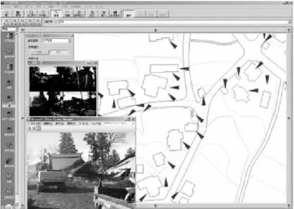
Example of Spatial Temporal database.
Contact
Hiroyuki Yamada (Research Fellow), Takashi Furuto (Technical Staff) and Shigeru Kakumoto (Invited Research Fellow) 4th Floor, Human Renovation Museum, 1-5-2, Wakinohama-kaigan-dori, Chuo-ku, Kobe, Hyogo, 651-0073, JAPAN yamada edm.bosai.go.jp (Yamada), furuto (Furuto), kaku (Kakumoto)
2. Major significance / Summary
The aim of this activity was to improve efficiency of earthquake disaster recovery operation for victims’ relief. Significant issue is to achieve the information processing required in recovery service by spatial-temporal GIS. Therefore, through the support of municipality, establishment and verification of the system was done and the system was identified to contribute to improvement of efficiency of recovery operation.
3. Keywords
Municipality, recovery operation, Spatial-Temporal GIS
II. Categories
4. Focus of this information
Implementation Oriented Technology (IOT)
5. Anticipated Users
5-1. Practitioners: Administrative officers, Municipalities, National governments and other intermediate government bodies (state, prefecture, district, etc.), Experts, Information technology specialists
5-2. Other users: Motivated researchers
6. Hazards focused
Earthquake, Multi-hazard
7. Elements at risk
Information and communication system
III. Contact Information
8. Proposer(s) information (Writer of this template)
Hiroyuki Yamada (Research Fellow), Takashi Furuto (Technical Staff) and Shigeru Kakumoto (Invited Research Fellow) 4th Floor, Human Renovation Museum, 1-5-2, Wakinohama-kaigan-dori, Chuo-ku, Kobe, Hyogo, 651-0073, JAPAN yamada edm.bosai.go.jp (Yamada), furuto (Furuto), kaku (Kakumoto)
9. Place where the technology/knowledge originated
JAPAN;
10. Names and institutions of technology/knowledge developers
Earthquake Disaster Mitigation Research Center (EDM) National Research Institute for Earth Science and Disaster Prevention (NIED)
11. Title of relevant projects if any
12. References and publications
Supporting Municipality Using Spatial Temporal GIS in 2004 Niigata-ken Chuetsu Earthquake, Hiroyuki YAMADA, Furuto TAKASHI, Naofumi SASAKI, Kaoru FUKUYAMA, Koji YOSHIKAWA and Shigeru KAKUMOTO, Proceedings of the 7th International Cooperative Seminar between KAGIS & GISA, pp.53-60, 2005.
13. Note on ownership if any
IV. Background
14. Disaster events and/or societal circumstances, which became the driving force either for developing the technology/knowledge or enhancing its practice
The Niigata-Ken Chuetsu Earthquake was occurred in October 23 in 2004. The earthquake gave devastating damages on houses, lifeline, agriculture, and others related to livelihood. Recovery services of the municipality were not working properly. The reduction of human loss is more important. But rapid recovery can also reduce economic loss and it is a part of disaster reduction. Additionally, municipal service was not working well because of discrepancy between record of ledger and the state of the affected area. It caused the delay of recovery and reconstruction.
V. Description
15. Feature and attribute
Aim: Disaster reduction using information technology.
Key mechanism: Efficiency improvement of recovery operation
Information problem to be solved, which were identified from the support activity on the site were as below;
- reduction of information processing time relate to recovery operation - register and referring of disaster situation
- discrepancy between map and the state of the affected areas - man-machine interface of information checking up
For the resolution of this problem, it is considered that cooperating many RDB with common unique ID or incorporating spatial positional relation with GIS which define topology. The fundamental factors of information management of municipality are family unit code, house address, and the number of each house. Area which home addresses shows is just a site which has house(s), and the address does not indicate specific location of each house. In other words, size of house site (family unit code or taxpayer code) is ranged from tens of square meters to hundreds of square meters orders but house need accuracy of scale of several meters to tens of meters to be recognized. Therefore, the current information database could identify address of houses but not identify more specific location than space which address shows. To achieve prompt recovery, integration of information from different dissolution levels is necessary for municipality recovery operation.
The solution is spatial key (x, y, t: t is period of information) as DB index. In addition, adding information of location and time (period) is entered to DB. Spatial Temporal GIS enable the dynamic topology calculation. To achieve the proposed information processing, the elements of Spatial-temporal information processing, decentralized independence information processing, open and public data schema, and spatial-temporal database are required. Fig. 1 shows procedures. Respective information is processed to be read out with spatial information of ID or attribute from each DB. Then, for calculating spatial topology, it is needed to sort out the correlation of space where attribute information exist. Consequently, attribute information is correlated in map (border of government such as street name, border of lot number, shape of house and so on) that border of space is previously described in time of attribute information exists. When using map, ID
of attribute is described on a map. Topology on a map is defined by this processing. Spatial Temporal GIS enable the dynamic topology calculation.
Fig.1 Spatial-temporal information processing procedures
16. Necessary process to implement
17. Strength and limitations
One example of strength:
Spatial-temporal photographic databases of disaster damage are constructed. Effectiveness of photographic data is shown below.
- It is useful as objectivity information on comparing.
- Making up of information difference at map and current state - Record and reference to disaster situation
Limitation:
The map should be suited to the current status prior to disasters. Construction of Spatial Temporal data base (base map, fixed asset ledger data, etc.) is necessary before disasters.
18. Lessons learned through implementation if any
VI. Resources required
19. Facilities and equipments required
Spatial Temporal GIS and Laptop PC, (According to the situation: scanner, GPS unit, GPS camera) were required.
20. Costs, organization, manpower, etc.
Cooperation of local government is absolutely crucial.
Spatial Temporal GIS is developed by NIED. Software fee is free for non-commercial use.
The base map construction cost depends on the situation. (digitize from paper map, digitize from satellite image, etc.) GPS digital camera: 80,000 yen (about 700 US$)
GPS unit: 20,000 yen (about 170 US$) Scanner: 40,000 yen (about 350 US$)
VII. Message from the proposer if any
21. Message
"Applicability of world wide"
In 1999 Kocaeli Turkey Earthquake, DiMSIS applied disaster information management in Duze city. Afterwards, DiMSIS is used by routine work in the Duze city. In addition, system were customized to intended for the task. The initial cost and running cost can be cut down compared with conventional GIS. DiMSIS license managed consortium agreement and DiMSIS can be provided free of charge in case of non-commercial use. Cooperate with other systems is available, because DiMSIS employ open data structure and open API. The
converter of shape and the DXF format were commercially available in general market. Disaster information management can be streamlined by managed with the position and time based on DiMSIS. Momentarily managed to handle information is required when the catastrophic disaster, and disaster information management based on address and the index is difficult to execute recovery operations at the municipality. DiMSIS contributed to the promotion of streamlining for recovery service at municipality in time of the Great Hanshin Earthquake in 1995 and the 2004 Niigata-ken Chuetsu Earthquake, etc.
VIII. Self evaluation in relation to applicability
22. How do you evaluate the technology/knowledge that you have proposed?
It is a technology/knowledge that is shown to be effective based on case studies/experiments in field sites.
23. Notes on the applicability if any
IX. Application examples
No.1
E1-1. Project name if available
Supporting Municipality Using Spatial Temporal GIS in 2004 Niigata-ken Chuetsu Earthquake.
E1-2. Place
Areas devastated by the Niigata-ken Chuetsu Earthquake.
(Tokamachi city, Kawaguchi town) E1-3. Year
2004 E1-4. Investor
NIED, GIS Association of Japan E1-5. People involved
Recovery services at the municipality after Niigata-ken Chuetsu earthquake has been assisted under the support of GIS Association of Japan. A GIS volunteer group was organized for the Spatial-temporal GIS-SIG and the Disaster GIS-SIG special activities.
E1-6. Monetary costs incurred
The base map construction cost is about 500,000 yen.
Staying cost of volunteer student is about 700,000 yen (About two months) E1-7. Total workload required
Case example:
The Kawaguchi town recorded the maximum seismic intensity and house damage was extensive. In the whole area of the Kawaguchi town received extensive damage from the earthquake (house, road, and farmland). The photograph databases of the all houses (dwelling house and incidental house) were constructed. Six volunteers executed the registration of about 5,000 pieces photographs (about 1,600 family units) in five days. (Fig. 2)
Fig. 2 Example of Spatial Temporal database
Fig. 3 Example of utilization for local government Total workload Activity period:
About 150 man-day. (Activity period: About two months) E1-8. Evidence of positive result
Spatial-temporal GIS was used for management of recovery services by municipality staff. The support activities in the municipality contribute to improve efficiency of recovery services.
X. Other related parallel initiatives if any XI. Remarks for version upgrade
Attached files:
DRH-Asia Contents (DRH 4) I. Heading
1. Title
Disaster Protection Technology of Traditional Wooden cultural Buildings
ID: DRH 4
Hazard: Earthquake, Cyclone/Typhoon
Category:
Transferable indigenous knowledge (TIK)
Proposer: Yasuhiro Araki
Country: JAPAN;
Date posted: 15 January 2008 Date published: 29 August 2008
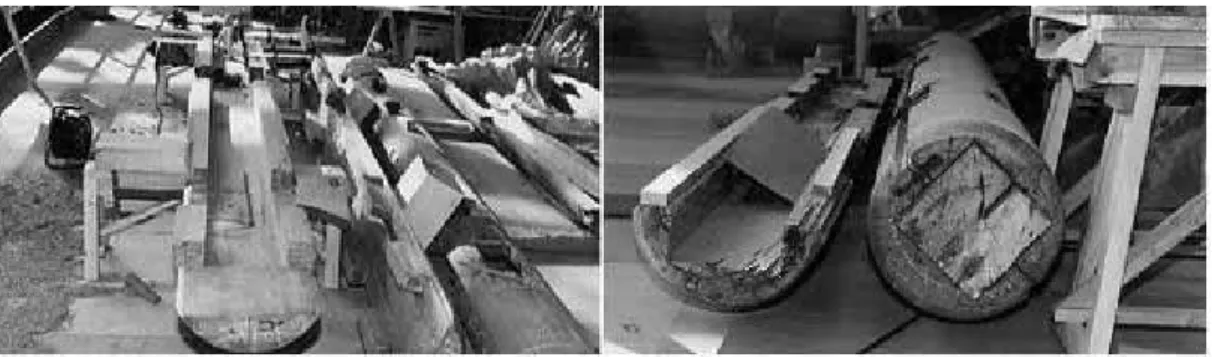
Examples of repair with dismantlement.
Contact
Yasuhiro Araki Research Fellow,
National Research Inst. for Earth Science and Disaster Prevention (NIED), Earthquake Disaster Mitigation Res. Ctr. (EDM)
araki edm.bosai.go.jp
2. Major significance / Summary
Japanese traditional wooden cultural buildings have been survived for long times.
The key technology for surviving may be “regular maintenances with appropriate intervals”, and this technology brings the sustainability of buildings.
3. Keywords
Sustainability of buildings; Regular maintenance with appropriate intervals
II. Categories
4. Focus of this information
Transferable indigenous knowledge (TIK)
5. Anticipated Users
5-1. Practitioners: Administrative officers, National governments and other intermediate government bodies (state, prefecture, district, etc.), NGO/NPO project managers and staff, Experts, Architects and engineers, Environmental/Ecological specialists
5-2. Other users:
6. Hazards focused
Earthquake, Cyclone/Typhoon
7. Elements at risk
Buildings, Cultural heritages