Conceptual Model Development for Groundwater
Flow and Origin Based on Geochemical and
Isotopic Analysis
著者
BAYANZUL BATDEMBEREL
学位授与機関
Tohoku University
学位授与番号
11301甲第18795号
Doctoral Dissertation Summary
Conceptual Model Development for
Groundwater Flow and Origin
Based on Geochemical and Isotopic Analysis
(地球化学および同位体分析による
地下水の流動と起源に関する概念モデル作成)
Graduate School of Environmental Studies, Tohoku University
Department of Environmental Studies for Advanced Society
Student No.
B6GD1007
NameBATDEMBEREL BAYANZUL
指 導 教 員
Supervisor at Tohoku Univ.
Prof. Takeshi KOMAI
研 究 指 導 教 員 Research Advisor at Tohoku Univ. 審 査 委 員 (○印は主査) Dissertation Committee Members The name marked with “○” is the Chief Examiner
○
Prof. Takeshi KOMAI1
Prof. Chihiro INOUE2
Assoc. Prof. Atsushi OKAMOTO
3
Dr. Isao MACHIDA3 Chapter 1. Introduction
Mongolia is one of the largest landlocked country with no access to the ocean, with an area of 1 566 600 square kilometers and is bordered by Russia and China (Fig. 1a). In terms of area, Mongolia is the eighteenth largest country in the world and according to the 2018 census; the population was over 3.2 million. Mongolia’s Gross Domestic Production is built up of 13% agriculture, 30% industry, and 57% services. Consequently, the mining industry is the largest industry in Mongolia, and the country’s economy hugely depends on the export of ores (between 60 - 80% of total exports), mostly coal, copper, gold, and other nonferrous metals (Šimalčík 2016). The Tavan Tolgoi and Oyu Tolgoi mines are the two most important mining sites to the Mongolian government. The Tavan Tolgoi minecontains vast reserves of coal while the Oyu Tolgoi mine boosts large copper and gold deposits. The Oyu Tolgoi mine is estimated to hold over 44 million tons of copper and 1903 tons of gold. The two mining sites require significant amounts of water in order to achieve maximal output. Moreover, most of the biggest mineral deposits of Mongolia (including these two mines) are located in the SGR (Fig. 1b).
Climatically, Mongolia is characterized by dry and hot summers, long and cold winters, high-temperature fluctuations as well as low precipitation. The annual average air temperature in Mongolia is +0.7°C and, it is +8.5°C in the SGR, and - 7.8°C in the northern part of Mongolia (Batimaa et al. 2005). The annual mean precipitation in SGR is approximately 50-100 mm and about 300-400 mm in the northern part of Mongolia (Batimaa et al. 2011).
On the other hand, Mongolia is one of the sixty countries that has scarce water resources. The annual water resources potential of Mongolia is estimated to 34.6 km3, of which about
20% is groundwater and 80% is surface water resources. Unfortunately, only 20% of water consumption comes from surface waters, with the remaining 80% recovered by groundwater (Janchivdorj 2005).
4
Figure 1. a – Location of the SGR and its relationship to the Gobi Desert. b – The biggest mineral deposits in the SGR.
According to the climate condition of Mongolia, it is difficult to use surface water as a sustainable water resource. It is indicated that groundwater is the primary source of water supply for urban and industrial centers and animal husbandry in this region.
The significant isotopic and hydrogeochemical surveys have been in the middle and southern part of the Gobi Desert (northern China) such as the Badain Jaran Desert (Gates et al. 2008), the Heihe River Basin (Yang et al. 2011) and the Hexi Corridor (Wang et al. 2017a), while the northern part of the Gobi Desert (SGR) is still not well understood.
The study area is located in the northern part of the Khanbogd district, Umnugobi province, SGR (northern part of the Gobi Desert; Fig. 2a). The area is surrounded by the Khanbogd Mountains to the south, the Zogdor Mountains to the west, and the Ikh Shankh range and Gurvan Kharaat Mountains to the northwest and northeast, respectively (Fig. 2b).
5
Figure 2. Topography map showing: a – Location of the study area and its relationship to the Khanbogd district and Gobi Desert. b – Brief topography of the study area and sampling locations.
According to meteorological data, the mean annual temperature is about 8 °C with an average monthly temperature range of -12°C (January) and +25°C (July). The annual rainfall is less than 100 mm (during the last 40 years) in this region. The lowest annual rainfall recorded in 1982 (38.1 mm) and the highest annual precipitation was 194.0 mm in 2003. According to the annual environmental reports of the Oyu Tolgoi mine, the potential evaporation in the study area is approximately 3000 mm/year.
The study area is classified as the least studied area in the SGR. The earliest geological surveys of southern Mongolia were studied by Russian researchers (Geological mapping scale of 1:500 000, Kazakov et al. 1958; Khrapov et al. 1962; Marinov et al. 1975; Sanduijav et al. 1975). Water Exploration Department of the Umnugobi province conducted a geophysical
6
investigation and constructed wells with different depth. These wells (up to a depth of 150m), shallow tube wells (up to 30-50m) and shallow hand-dug wells (up to 5-15m) are used as a water supply for drinking and livestock purposes in this region.
Through a hydrogeological survey of shallow and deep groundwater in the Khanbogd district, the main aims of the thesis are to understand groundwater recharge processes in the Gunii Khooloi basin including shallow and deep groundwater characteristics, geochemical evolution, groundwater origin and groundwater age.
Chapter 2. Hydrogeochemical characteristics and groundwater geochemical evolution
According to field data, the mean pH of the spring water (8.0) is higher than that of shallow (7.8) and deep groundwater (7.9). However, the mean value of pH in shallow monitoring wells (8.7) and deep monitoring wells (9.7) are very high compared with other samples. It is clear that the temperature of shallow groundwater (12.3°C) is lower than that of deep groundwater (16.8°C). EC increases along the flow directions, with an average of 480 µS/cm in springs and 965 µS/cm in shallow groundwater. However, average value of EC in the deep groundwater is 4465 µS/cm, which is almost 4 times higher than shallow groundwater. Some shallow monitoring wells have high EC values (more than 2000 µS/cm) and some deep monitoring wells have low EC (less than 1000 µS/cm) compared to shallow and deep groundwater.
Field data and chemical components of monitoring wells are different from those of hand-dug wells and deep production wells. This implies that geochemical data of the monitoring wells may not be representative of hydrogeochemical conditions of the Gunii Khooloi area, due to its mixture and stagnant condition.
7
The classification of water quality was conducted using a Piper trilinear diagram (Piper 1944). The plots of shallow groundwater were dispersed in the Piper diagram (Fig. 3). Springs and a few samples from shallow groundwater in the study area are classified as Ca-HCO3 and
Na-HCO3 and some of them classified as a mixture of Ca-Na-HCO3 types. However, shallow
groundwater samples located close to the Elgen, Gurvan Kharaat mountains area in the Gunii Khooloi basin are classified as Na-Cl type. The Gunii Khooloi deep groundwater are predominantly chloride type, whereas samples from the western part of the aquifer are more sulfate-enriched than the eastern part of the aquifer.
Figure 3. Piper diagram for the chemical analysis of groundwater collected from Gunii
8 Chapter 3. Groundwater origin and age
Analysis of the aquifer system and hydrogeological conditions together with geochemical and isotopic techniques can provide information on the groundwater sources and their associated recharge processes (Coplen et al. 2000; Mahlknecht et al. 2004; Glynn and Plummer 2005; Ma et al. 2009). Stable isotopes and radioactive isotopes in groundwater has been used for determine the groundwater origin and age in semi-arid and arid regions.
Gobi desert is a one of the biggest deserts in the world and significant isotopic surveys have been conducted over the past decade in the middle or southern part of the Gobi Desert (northern China), such as the Badain Jaran Desert (Gates et al. 2008), the Shiyang River Basin (Ma et al. 2005), the Heihe River Basin (Yang et al. 2011), the Dunhuang Basin (Ma et al. 2013) and the Hexi Corridor (Wang et al. 2017a). However, the northern part of the Gobi Desert (SGR) is still not well understood.
For stable isotope analysis, totally 101 water samples were collected from the study area. All water samples for stable isotopes (δ18O and δD) were analyzed a liquid water isotope
analyzer (Picarro, L2120-i) at the National Institute of Advanced Industrial Science and Technology (AIST). The measured results were reported using the conventional delta (δ) notation, according to the Vienna Standard Mean Ocean Water (VSMOW) standard in per mille (δ‰), equation (2) as follows:
δsample = (Rsample
RSMOW − 1) x1000 (‰) (1)
where, Rsample is the isotopic ratio of 18O/16O or D/H of a water sample, and R
SMOW is the
isotopic ratio of 18O/16O or D/H of the VSMOW standard.
During the investigation, a total of 28 water samples were collected for the tritium analysis in 2017 and it included 3 rainwater, 1 spring, 15 hand-dug wells and 9 deep production
9
wells. In addition, 10 water samples for radioactive carbon analysis were collected from the deep aquifer in 2017.
The local meteoric water line in the study area has not been established. Stable isotope data taken from the International Atomic Energy Agency (IAEA) database (IAEA/WHO 2018) are highly variable. The stable isotope ratios, δD and δ18O, are given as conservative tracers of
groundwater origin. The δD and δ18O values of the precipitation samples ranged from -99 to
4‰ in δD and from -12.2 to 1.6‰ in δ18O. The stable isotopes in water for hand-dug wells
varied from -100 to -71‰ in δD and from -12.8 to -8.1‰ in δ18O. Most of shallow groundwater
samples are distributed below the GMWL and LMWL, which indicates that shallow groundwater originated from meteoric water. However, some shallow groundwater samples are plotted far from the LMWL (samples 5, 17, 19, 29 and 43-45). The δD and δ18O ratios in
deep groundwater from production wells varied from 94 to 87‰ in δD and from 11.6 to -9‰ in δ18O. In addition, stable isotopes in shallow groundwater.
Tritium (3H) activities for precipitation samples ranged from 31.9 to 41.9 TU and shallow
groundwater samples ranged from 3.1 (sample 30) to 36.1 TU (sample 47) except sample 5, 19 and 34. No significant tritium content could be detected in these exceptional shallow groundwater samples and deep groundwater samples (<0.3 TU, Fig. 24). More than 50 years is necessary for 3H to decrease below the quantitative limit from an initial 28.2 TU by
radioactive decay. In addition, concentration of the tritium in groundwater decreases decay law.
3
H=
3H
0
lne
-λt(3)
where 3H is tritium concentration in groundwater sample, 3H
0 is initial tritium value or
concentration of tritium in the recharge water, λ is the decay constant of tritium and t is groundwater age. According to the results, shallow groundwater age is less than 50 years old, which is classified as young groundwater. However, some shallow groundwater has been classified as old groundwater.
10
Deep groundwater with low tritium content was supposed to be recharged before 1952, and therefore some additional samples were collected to clarify groundwater age by 14C
method. According to the results, average age of deep groundwater in the Gunii Khooloi basin increases from approximately 22,500 years old (sample Nos. 69 and 70) to more than 33,500 years old (sample No. 77) along the groundwater flow direction up to the central part of the deep aquifer. Therefore, the water resources are essentially non-renewable in the Gunii Khooloi aquifer.
Chapter 4. Development of hydrogeological conceptual model
Water resource has become an important issue restricting the socio-economic and sustainable development. Groundwater over exploitation for irrigation has been observed in northern China (Qiu 2010; Bradsher 2011; Currell et al. 2012) which is close to the study area. The use of major ions has become a usual method to define groundwater chemistry in aquifers. Commonly, the approach is to group groundwater samples into hydrogeochemical facies i.e., groundwater samples with similar hydrogeochemical characteristics that can then be correlated with location (Güler et al. 2002). Thus, analysis of the aquifer systems and hydrogeological conditions together with hydrogeochemical data using multivariate analysis can provide relationship between shallow and deep aquifer and their associated recharge processes. Several commonly used multivariate statistical techniques are available including hierarchical cluster analysis (HCA) and principal components analysis (PCA).
Therefore, multivariate statistical analysis (including HCA and PCA) were used to clarify relationships between shallow and deep aquifer systems in the Gunii Khooloi basin. For the analysis, totally 95 groundwater data were collected from the study area which included 2 springs, 45 hand dug wells, 8 shallow groundwater monitoring wells, 12 deep groundwater monitoring wells and 28 deep production wells. Sampling locations shown in Figure 2.
11
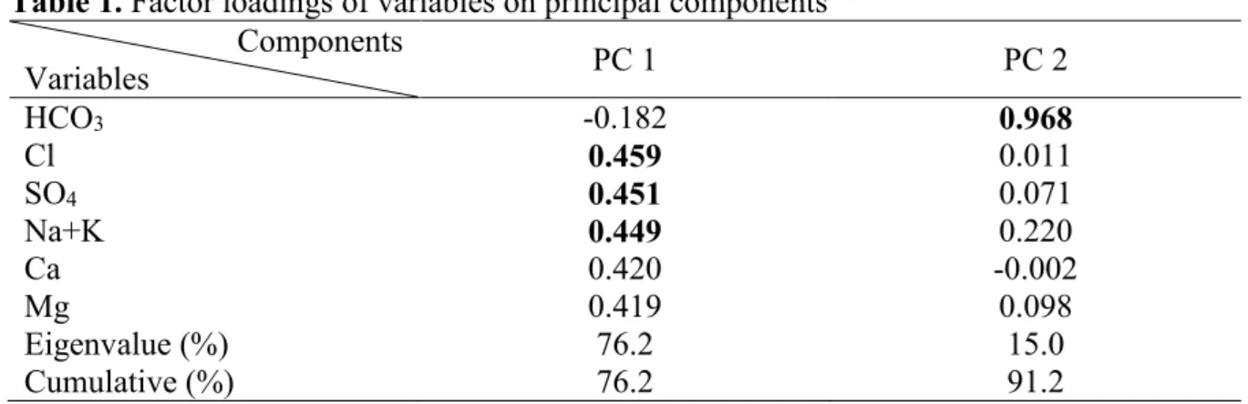
The PCA results of 6 major geochemical parameters (Ca, Mg, Na+K, HCO3, SO4 and Cl)
from 95 groundwater samples are shown Table 1. All the principal components having Eigenvalues less than 10% were excluded which resulted in the extraction of two principal components. The two PCs affecting quality of the groundwater are identified, which explains 91.2% of the data variability.
The data shown in bold in Table 1 indicate higher loading (greater than 0.44) to the responding components. PC 1, which accounts for 76.2% of the data variability, has highly positive loadings in Cl, SO4 and Na+K. The factor loadings for these parameters are 0.459,
0.451 and 0.449, respectively. Na and Cl ions are associated with hydrogeochemical variables from mineral weathering, ion exchange, evaporation, seawater dilution and water rock interaction in the aquifer, which indicates that PC1 would reflect climatic and lithological (geological) effects.
Table 1. Factor loadings of variables on principal components Components Variables PC 1 PC 2 HCO3 -0.182 0.968 Cl 0.459 0.011 SO4 0.451 0.071 Na+K 0.449 0.220 Ca 0.420 -0.002 Mg 0.419 0.098 Eigenvalue (%) 76.2 15.0 Cumulative (%) 76.2 91.2
Bold values represent strong (>0.44) and positive loadings According to factor score of PC 1 most of shallow groundwater have negative scores but deep groundwater have positive scores, which indicates that shallow and deep groundwater are classified as different aquifer systems.
12
However, some shallow groundwater (sample 5 and 18) have positive factor score same as deep groundwater and these shallow wells are located in Elgen and Gurvan Kharaat mountain area which indicates that these mountain area might be the recharge zone of the deep aquifer. PC 2 explains 15.0% of the total variance and shows highly positive loading for HCO3 (Table
1), which might be originating from dissolution of carbonate.
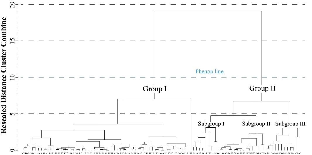
The dendrogram of HCA is presented in Figure 4. The phenon line is determined as the distance of 10, by which all groundwater data are classified into two significant main groups. Most shallow groundwater data classified in Group I, except several shallow hand dug wells in foothills. Group II is composed of the deep groundwater with some shallow hand dug wells. In additional, Group II can be classified as three different subgroups, which are connected with the location of samples except subgroup I. Mixed groundwater (Shallow and deep groundwater) might be clustered in subgroup I. Subgroup II and Subgroup III are classified as southwestern and northeastern part of the deep aquifer, respectively.
Several conceptual models have been developed in arid or semi-arid areas such as Nubian Sandstone Aquifer in the Negev, Israel (Vengosh et al. 2007), Djerid oasis water table aquifer in southern Tunisia (Kamel 2013) and northern China which includes Badan Jaran Desert (Gates et al. 2008), Ejina basin (Wang et al. 2013), Dunhuang Basin (Ma et al. 2013), Hexi Corridor (Wang et al. 2017a), Shule River Basin (He et al. 2015), Tenger Desert (Wang et al. 2017b) while hydrogeological conceptual model has not existed in northern Gobi desert. Based on our results of the isotopic analysis, hydrogeochemical interpretation and multivariate analysis, a first conceptual model of groundwater recharge, flow and geochemical evolution is proposed to further understand the hydrogeological conditions of the Gunii Khooloi basin, which is located in northern Gobi desert.
13
14
Information of these parameters can develop a more reliable conceptual model of hydrogeological systems, especially in arid and semi-arid regions, where high evaporation and less rainfall exist (Currell and Cartwright 2011; Herczeg and Leaney 2011; Wang et al. 2017b); therefore, a combination of hydrogeochemistry, isotopic analysis and multivariate analysis is an effective and comprehensive approach to understand the groundwater flow.
The shallow streambed aquifer is recharged by local precipitation in the Gunii Khooloi basin. In the Ikh Shankh range, Elgen and Gurvan Kharaat Mountain area, the isotopic and hydrogeochemical compositions of the shallow groundwater tend to conform to patterns similar to the deep confined aquifer, which indicates that those areas could be the recharge area of the deep confined aquifer. In contrast, stable isotope ratios in the shallow groundwater, geochemical compositions and tritium data in the Duulga Mountain area are different from the others. In addition, this result is supported by multivariate analysis.
Chapter 5. Conclusions
Water resource is an important issue in the arid and semi-arid regions such as Gobi Desert. Groundwater over-exploitation use for irrigation has been recognized in the southern part of the Gobi Desert (Northern China) and groundwater usage is increased significantly by mining industries in the SGR. This thesis investigated groundwater recharge processes including shallow and deep groundwater characteristics, geochemical evolution in the groundwater systems, groundwater origin in aquifer systems through a combination of the isotopic data and hydrogeological information, as well as groundwater age in the Gunii Khooloi basin, SGR, and revealed the following results.
1. Water temperature in the shallow groundwater is colder than deep groundwater in the Gunii Khooloi basin and groundwater pH is neutral to a slightly alkaline in the shallow (7.8) and deep aquifer (7.9). Electric conductivity in deep groundwater is approximately 4 times higher than shallow groundwater.
15
2. Shallow groundwater in the study area is classified as Ca-HCO3, Na-HCO3,
Ca-Na-HCO3. In case of Gunii Khooloi deep aquifer, groundwater is classified as Na-Cl type
and EC increases along the flow direction.
3. The mean values of stable isotopes in shallow groundwater are -81‰ in δD and -10.5‰ in δ18O and plots on the LMWL that indicates shallow groundwater originated from
meteoric water. However, mean values of δD and δ18O in deep groundwater are -93‰
and -10.6‰, respectively, which plot on the evaporation line. The depleted isotopic signatures are considered to be origin of paleowater, when the climate was colder and wetter than the present day.
4. According to 3H results, shallow groundwater age is less than 50 years old, which is
classified as young groundwater. In deep groundwater, 14C activities are between 0.74
to 3.3 pMC, except for sample Nos. 22 (30.1 pMC) and 24 (14.9 pMC). The average age of groundwater in the Gunii Khooloi aquifer increases from approximately 22,500 to 33,500 BP along the groundwater flow direction. However, younger groundwater (2800 before present) observed in northern edge of the aquifer which may influenced by young groundwater and groundwater resource in this basin is essentially non-renewable.
5. The first hydrogeological conceptual model of the Gunii Khooloi basin is developed by the current investigation, and shallow and deep groundwater in the Gunii Khooloi basin are totally different aquifer systems (no relationship between them) based on their hydrogeological and isotopic compositions and multivariate analysis.
6. The stable isotopic results clearly imply that there is no direct recharge connection between the aquifer and direct modern recharge. Shallow groundwater is originated from meteoric water, while deep groundwater is originated from paleowater.
16
7. Due to the abnormal physical, geochemical and isotopic compositions of water in the monitoring wells, they should improve the monitoring well design for the water to be representative of the hydrogeochemical condition in the Gunii Khooloi basin.
References
Batimaa P, Myagmarjav B, Batnasan N, Jadambaa N, Khishigsuren P (2011) The Urban Water Vulnerability to Climate Change in Mongolia. Ministry of Nature, Environment and Tourism Water Authority, Mongolia
Batimaa P, Natsagdorj L, Gombluudev P, Erdenetsetseg B (2005) Observed Climate Change in Mongolia. Assessments Impacts Adapt to Clim Chang
Bradsher K (2011) U.N. Food Agency Issues Warning on China Drought. New York Times 9-12
Coplen TB, Herczeg AL, Barnes C (2000) Isotope engineering-using stable isotopes of the water molecule to solve practical problems. In: Cook, P.G., Herzeg A. (ed) Environmental Tracers in Subsurface Hydrology. Kluwer, Boston, pp 79-110
Currell MJ, Cartwright I (2011) Major-ion chemistry, δ13C and 87Sr/86Sr as indicators of hydrochemical evolution and sources of salinity in groundwater in the Yuncheng Basin, China. Hydrogeol J 19:835–850
Currell MJ, Han D, Chen Z, Cartwright I (2012) Sustainability of groundwater usage in northern China: Dependence on palaeowaters and effects on water quality, quantity and ecosystem health. Hydrol Process 26:4050-4066
Gates JB, Edmunds WM, Darling WG, Ma J, Pang Z, Young AA (2008) Conceptual model of recharge to southeastern Badain Jaran Desert groundwater and lakes from environmental tracers. Appl Geochemistry 23:3519–3534
17 Hydrogeol J 13:263–287
Güler C, Thyne GD, McCray JE, Turner AK (2002) Evaluation of graphical and multivariate statistical methods for classification of water chemistry data. Hydrogeol J 10:455–474 He J, Ma J, Zhao W, Sun S (2015) Groundwater evolution and recharge determination of the
Quaternary aquifer in the Shule River basin, Northwest China
Herczeg AL, Leaney FW (2011) Review: Environmental tracers in arid-zone hydrology. Hydrogeol J 19:17–29
IAEA/WHO (2018) Global Network of Isotopes in Precipitation. The GNIP Database. https://nucleus.iaea.org/wiser. Accecced 24 January 2018
Janchivdorj L (2005) Current Social and Environmental Situation of the Selenge River Basin and Associated Management Challenges, Institute of Geoecology, Mongolian Academy of Sciences, Ulaanbaatar, Mongolia
Kamel S (2013) Salinisation origin and hydrogeochemical behaviour of the Djerid oasis water table aquifer (southern Tunisia). Arab J Geosci 6:2103–2117
Khrapov A., Alekhin S., Argunov M. (1962) Geological map of the Dundgobi, Umnugobi and Dornogobi provinces, The People’s Republic of Mongolia, Scale 1:500 000 (in Russian) Ma J, Ding Z, Edmunds WM, Gates JB, Huang T (2009) Limits to recharge of groundwater
from Tibetan plateau to the Gobi desert, implications for water management in the mountain front. J Hydrol 364:128–141
Ma J, He J, Qi S, Zhu G, Zhao W, Mike Edmunds W, Zhao Y (2013) Groundwater recharge and evolution in the Dunhuang Basin, northwestern China. Appl Geochemistry 28:19–31 Ma JZ, Wang XS, Edmunds WM (2005) The characteristics of ground-water resources and their changes under the impacts of human activity in the arid Northwest China - A case
18
study of the Shiyang River Basin. J Arid Environ 61:277–295
Mahlknecht J, Schneider JF, Merkel BJ, Navarro de LI, Bernasconi SM (2004) Groundwater recharge in a sedimentary basin in semi-arid Mexico. Hydrogeol J 12:511–530
Marinov N., Khasin R. (1975) Geological map of the Central and Eastern Mongolia, The People’s Republic of Mongolia, Scale 1:500 000 (in Russian)
Piper AM (1944) A graphic procedure in the geochemical inter- relation of water analyses. Trans Am Geophys Union 25:914–928
Qiu J (2010) China faces up to groundwater crisis. Nature 466:308
Šimalčík M (2016) Influence of Foreign Direct Investments on the Development of Mongolia. Available at SSRN: https://ssrn.com/abstract=2883745 or http://dx.doi.org/10.2139/ssrn.2883745
Vengosh A, Hening S, Ganor J, Mayer B, Weyhenmeyer CE, Bullen TD, Paytan A (2007) New isotopic evidence for the origin of groundwater from the Nubian Sandstone Aquifer in the Negev, Israel. Appl Geochemistry 22:1052–1073
Wang L, Dong Y, Xu Z (2017a) A synthesis of hydrochemistry with an integrated conceptual model for groundwater in the Hexi Corridor, northwestern China. J Asian Earth Sci 146:20–29
Wang L, Dong Y, Xu Z, Qiao X (2017b) Hydrochemical and isotopic characteristics of groundwater in the northeastern Tennger Desert, northern China. Hydrogeol J 1–13 Wang P, Yu J, Zhang Y, Liu C (2013) Groundwater recharge and hydrogeochemical evolution
in the Ejina Basin, northwest China. J Hydrol 476:72–86
Yakovlev B., Sanduijav G, Garamjav D, Ganbaatar T (1975) The Tsagaansuvarga and the Mantakh copper ore knots of southeastern Mongolia: Geological setting and natural
19
distribution of useful mineral deposits in the territory of Mongolia. Nedra, Moscow, p. 57-66 (in Russian).
Yang Q, Xiao H, Zhao L, Yang Y, Li C, Zhao L, Yin L (2011) Hydrological and isotopic characterization of river water, groundwater, and groundwater recharge in the Heihe River basin, northwestern China. Hydrol Process 25:1271–1283