B11
Study on Planning of a Small Hydropower Development under Consideration with the Basin
Environment
〇Kazuki TERADA, Tetsuya SUMI, Yasuhiro TAKEMON, Motoyuki INOUE
Introduction
After the Great East Japan earthquake on March 11 in 2011, renewable sustainable energy projects in local areas have been increasing to improve energy self-sufficiency and make energy diversity and decentralization because of dramatic decrease of nuclear power production and violent fluctuations of fossil fuel prices. Small hydropower projects are paid more attention in these projects in terms of low life cycle cost, high capacity factor and contribution to local community creation. In this paper, we propose a procedure for small hydropower considering with the basin ecosystem which develop local communities using their original natural resource.
Study area and methods
The studies was conducted in the Ochiai River located in the Yoshii River system (Fig. 1). A small hydropower project are planned for local revitalization in Aba villege where the Ochiai river is flowing.
Flow volumes of the Ochiai River were calculated
by multiplying the measured discharge at the Monomi observatory downstream and at the Osugi observatory in the Kamo River with a relative ratio of these three catchment areas. We used the Mushiake’s method to calculate flow regimes for calibration.
At each water intakes, we calculated hydropower generation. In addition, we validate new methods to set environmental flow cosidering inflow from a branch river.
Field surveys were conducted on physico-chemical factors and aquatic animal communities in the Ochiai river basin from Sep to Dec 2016. At 8 stations in the basin, micro habitat composition, water quality parameters (temperature, pH, EC, etc) and canopy openness were measured. Benthic animals and fishes were collected qualitatively in the waterfall, riffle and pool habitats, separately. We used the EPT index and ASPT index (Nozaki, 2012) for environmental evaluation of benthic communities.
The Ochiai River has many water falls forming picturesque landscapes. We took pictures in representative waterfalls and measured white surface area of spray and bubble by image analyses to estimate waterfall scenery by changes of flow volume.
Fig. 2 Duration curves calculated by relative ratio of Monomi, Osugi flow volumes in 2005 and made by Mushiake's method Fig. 1 Map of study area in the Ochiai River
Results and Discussion
Comparing with calculated flow regime, Fig.2 shows flow regime in Osugi observatory is more stable than those in Monomi observatory and Mushiake’s method (Mushiake, 1981) because water retention of the Kuroiwa Moorland in the upstream Ochiai river is high. When 0.5 ㎥/s are intake from upper sabo dam, we could get highest hydropower production. Furthermore, Fig.3 shows we get about 10 % more hydropower production when we decrease environmental flow discharge considering a tributary inflow shown in Fig. 1 than when we used conventional method.
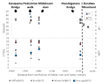
Fig. 5 shows both pH and EC showed low values in the Kuroiwa Moorland because of the marsh vegetation and bog accumulation in the moorland producing organic acid, whereas they increased rapidly in the downstream reaches to Hozukiganaru Bridge, probably because of groundwater input from the slopes and tributaries. Aquatic fauna of the Ochiai River was characterized by a set of highly rare species such as the
fluvial eight-barbel loach (Lefua sp.), the Japanese clawed salamander (Onychodactylus japonicus), and the Japanese fluvial sculpin (Cottus pollux) found in the upper reaches near Hozukiganaru Bridge. Although the values of ASPT index were not so different among sites, those of EPT index showed the highest value at Midstream-dam site. These results indicate that the upper reaches near Hozukiganaru Bridge should be conserved in high priority as the rare species habitats and middle reaches along the nature trail should be conserved as rich EPT species habitats.
Fig. 5 shows both relationship between the white area and flow volume in two points are non-linear. This reason is that white area in waterfall are increasing nonlinearly in proportion to flow volume.
Conclusion
We found more clearly environmental important areas through physico-chemical and ecological investigation in the basin scale which leads to effective hydropower production keeping characteristic aquatic fauna and scenic beautiful spots. Besides, we need to get flow rate data in the Ochiai river for calibration of duration curves and conduct field surveys to know seasonal biota and these habitat.
References
Nozaki T. (2012) Biological assessment based on macroinvertebrate communities -Average Score System for Japanese rivers-. Journal of Japan Society on Water Environment 35: 118-121.
Mushiake K. (1981) Effects of basin geology on river-flow regime in mountainous areas of Japan –Journal of Japan Society of Civil Engineering 309: 51-62
Fig. 5 Relationship between bubbling area percentage and flow rate
Fig. 3 Comparison of energy generation between environmental discharge considering branch inflow under upstream dam and that not considering it
Fig. 4 Relationship between ecological evaluation (EPT and ASPT) and chemical data (pH and EC)