A STUDY ON EVALUATION OF STREETSCAPE IN
JAPAN AND CHINA
(日本と中国における街路景観の評価に関する研究)
山梨大学大学院
医学工学総合教育部
博士課程学位論文
2013 年 9 月
LI LI
A STUDY ON EVALUATION OF STREETSCAPE IN
JAPAN AND CHINA
(日本と中国における街路景観の評価に関する研究)
September 2013
LI LI
日本と中国における街路景観の評価に関する研究
山梨大学大学院
医学工学総合教育部
博士課程学位論文
2013 年9月
LI LI
A STUDY ON EVALUATION OF STREETSCAPE IN
JAPAN AND CHINA
A dissertation submitted in partial fulfillment of requirements for the degree of Doctor of philosophy in Engineering
Global Center of Excellence (GCOE)
Special Doctoral Course on Integrated River Basin Management in Asian Region Interdisciplinary Graduate School of Medicine and Engineering
University of Yamanashi, Japan
September 2013 LI LI
i
Acknowledgements
My deepest gratitude goes first and foremost to Prof. Shinichi Kitamura, my supervisor, for his constant encouragement, guidance and all kinds of support provided throughout the research as well as study in Japan. Without his consistent and illuminating instruction, this thesis could not have reached its present form. I would like to express my heartfelt gratitude to Assoc. Prof. Toshio Shimokawa for his kind instruction and help on statistical analysis.
I am also greatly indebted to the prof. Isao Oyama, and Prof. Taku Misonou, who have instructed and helped me a lot in the past three years.
My thanks go to Prof. Kuniaki Sasaki and Prof. Tomoko Takahashi for serving on my committee and the valuable suggestions.
I would highly appreciate Mr. Chen Yiran, Ms. Wang Na, Mr. Fu Yi, Mr. Chen Peng and the lab-staff Mr. Shohei Tsuchida for their encouragement.
My special thanks to GCOE-staffs for their valuable and efficient administrative support.
I am very grateful to the Global Center of Excellence (GCOE) program of the University of Yamanashi, and the Japanese Government (MEXT) , for making this study possible through their financial support.
Last my thanks would go to my beloved family for their loving considerations and great confidence in me all through these years.
ii
Abstract
Development of urban transport infrastructure has been progressing rapidly accompanied by large economic growth in recent years. Urban transport infrastructure development will not only bring convenience to the community, but also impact the living environment. Therefore, it is important to build a transport infrastructure that has an appropriate trade-off between its function and the conditions of the urban environment. Nowadays, the urban transportation faces many problems due to the excessive development of economy. Since the number of cars on the roads keeps increasing, the improvements in road size, quality, and quantity have steadily progressed, while pedestrian space has been neglected. In many situations, in order to provide enough space to the traffic, the width of sidewalk along the main streets often has to be set far below the required standard. Besides that, the pedestrian space is often occupied by bikes and advertisement boards. These result in the low comfort of the streetscape. We believe that, during the transport development, it is important for city authorities to plan and conduct qualitative maintenance (with emphasis on landscape) along with quantitative maintenance (with emphasis on efficiency). In order to do that, clarifying the importance of physical factors on evaluation of streetscapes and their effective operation is necessary. At the same time, we know that a city street by itself is nothing, it is an abstraction, and it means something only in conjunction with its users, city dwellers. People’s evaluation on the streetscape is precious and important. City authorities should plan and conduct maintenance with respect to people’s demand.
As typical developed and developing countries, Japan and China are facing the same problem regarding streetscapes, and chronic congestion is now a feature of the roads in these two countries. It would be prudent for both Japan and China to conduct both qualitative and quantitative maintenance of their urban infrastructure, although they are in different stages of economic development. We have seen that a vast amount of scholarships has been devoted to evaluate streetscapes in Japan and China. However, the physical factors influencing streetscape evaluation are different in each country, therefore, China cannot directly apply Japan’s experiences without any processing. Thus, it is important for us to understand the
iii
similarities and differences between the target cities. In this study, we consider the similarity in many aspects such as culture, population, transportation infrastructure, etc. Chengdu, China and Tokyo, Japan were selected as our target areas and a questionnaire on main roads and familiar narrow streets was conducted in both cities. Among the questionnaire respondents, 100 graduate students are from the Southwest Jiaotong University in Chengdu, China and 159 undergraduate students enrolled in the Faculty of Humanities and Environment at Hosei University, Japan. The survey was conducted in August 2011, and it requires respondents to think about the most impressive street they knew in their respective cities and fill in the questionnaire accordingly. Impressive main roads are those with more than 3 lanes and sidewalks, and impressive familiar narrow streets are those with less than 2 lanes and sidewalks. In addition, the questions were graded on a five-grade evaluation scale based on the semantic differential (SD) method.
Given the survey, we will analyze physical influencing factors and obtaining useful information on qualitative maintenance to identify the factors for streetscapes evaluation, which will provide suggestions for street maintenance. To achieve this goal through the questionnaire of streetscape in Tokyo Japan and Chengdu China, the following specific objectives are set up: 1) to clarify the physical factors affecting the streetscape evaluation, 2) to reveal the distinction of influential physical factors between Japan and China, and 3) to introduce a new methodology to evaluate streetscape.
Multiple linear regression analysis is one of the most popular methods for performing data analysis of questionnaires. However, it cannot construct a model with an interaction effect and nonlinear structure. Among the perceptual data, if there is an external criterion, the relationship between the explanatory variables and responses is often non-liner. As a result, the classification and regression tree has been extensively used in the literature. Nevertheless, this method has a significant limitation, low prediction accuracy. Therefore, the exploration of statistical model that can be interpreted easily and superior in the prediction accuracy is essential.
In this research, the similarities and the differences on the streetscapes in Japan and China were understood with Mann-Whitney Wilcoxon test. Following that, Breiman’s random
iv
forests method, one of the most famous ensemble learning methods, was used to analyze the data obtained from the survey on main roads (primary and district distributor roads) based on factor analysis method. It is shown that the three chief factors affecting evaluation of streetscapes are comfort, beauty, and activity. There is no significant difference in comfort evaluation and beauty evaluation between two cities. For comfort, the number of shops strongly influences the evaluation of comfort for both Tokyo and Chengdu, and comfort plummets with too many shops. Density has a strong impact on comfort in Chengdu, and lower density leads to higher comfort. We also get that for Chengdu, comfort of streetscapes is strongly influenced by landscape and spatial situations. For beauty, the density has the strongest influence in both Tokyo and Chengdu, and beauty reduces heavily at a great scattering. An increase in the quantity of houses decreases the level of beauty in Tokyo, but increases the one in Chengdu. In other words, the impact of building usage was stronger in Tokyo than in Chengdu. For activity, the activity score of Tokyo was significantly higher than that of Chengdu, and the congestion of street has the strongest influence for both Tokyo and Chengdu, with decreasing activities, streets become vacant.
Regarding the survey on local distributor roads, conditional inference trees method was used. The conditional inference tree which consists of binary split tree based on the permutation test statistics can be explained influencing factors for local distributor roads in the form of production rules. We found that for the perceptual items (comfort, beauty, affinity), Tokyo has higher satisfaction, while for the functional item (ease of walking), Chengdu is much better than Tokyo. Beautiful buildings play a positive role in the comfort and beauty of streetscapes, while the bad pavement of sidewalk has negative affect on the comfort and the beauty of streetscapes. Maintenance of sidewalk pavement is a key way to eliminate the negative impression of comfort and beauty in local distributor roads. The impact of the beauty of the architecture is much more influential to the comfort evaluation in Chengdu’s local distributor roads than that in Tokyo. Maintenance of roadside trees, as a positive factor, is important to comfort evaluation of local distributor roads. In the aspect of affinity, Tokyo has a stronger affinity of the local distributor road than Chengdu. In Tokyo, the quantity of shops has a positive effect on affinity, and in Chengdu, the beauty of buildings plays the positive role. The ease of walking is heavily impacted by the obstacles of local distributor
v
roads. In addition to that, by strengthening the quality of sidewalk pavement, the ease of walking could be improved dramatically.
The fundamental knowledge we found about the differences and similarities between the evaluations of streetscapes in Japan and China will be useful for streetscape maintenance and will be a valuable lesson for the streetscape development of China. In order to achieve the ultimate goal that providing maintenance method of streetscape in both Japan and China, extracting the common influential factors and constructing the international model, more regions in Japan and China even in the worldwide covering more age groups will be studied by the same method and the physiological- psychological experiments based on objective data of this research will be conducted in the future.
vi
Table of Contents
Acknowledgements ... i
Abstract ... ii
Table of Contents ... vi
List of Figure ... viii
List of Tables ... ix Chapter 1 Introduction ... 1 1.1 Background ... 1 1.2 Motivation ... 2 1.3 Objective ... 4 1.4 Dissertation outline ... 4
Chapter 2 Literature Review ... 7
2.1 Study in the streetscape constituent factors ... 7
2.1.1 Streetscape evaluation based on SD method ... 7
2.1.2 Multi-factors ... 9 2.1.3 Single factor ... 10 2.2 Experimental method ... 11 2.2.1 CG, montage, video ... 12 2.2.2 Pilot experiment ... 13 2.3 Statistical method ... 14
2.4 Trends of papers on the evaluation of landscape ... 15
2.5 Summary ... 16
2.5.1 Outline of existing research ... 16
2.5.2 Deficiency of existing research ... 17
Chapter 3 Study design ... 19
3.1 Subject region for questionnaire ... 19
3.1.1 Brief introduction of Tokyo city ... 19
3.1.2 Brief introduction of Chengdu city ... 22
vii
3.1.4 Classification of the street ... 27
3.2 Formation of the questionnaire ... 29
3.2.1 Questionnaire of primary and district distributor road ... 29
3.2.2 Questionnaire of local distributor road ... 31
3.3 Implementation of the questionnaire ... 31
Chapter 4 Streetscape Evaluation of primary and district distributor roads ... 33
4.1 Overview of statistical analysis ... 33
4.2 Introduction of random forest method ... 34
4.3 Result ... 36
4.3.1 Summary of the result... 36
4.3.2 Estimation of factors affecting evaluation of streetscapes ... 38
4.3.3 Exploration of physical factors affecting evaluation of streetscape .. 40
4.4 Summary ... 48
Chapter 5 Streetscape evaluation of local distributor roads ... 49
5.1 Overview of statistical analysis ... 49
5.2 Introduction of conditional inference trees method ... 49
5.3 Totalled results of questionnaire ... 50
5.4 Exploration of factors affecting evaluation streetscape ... 55
5.4.1 Exploration of the factors affecting comfort ... 56
5.4.2 Exploration of the factors affecting beauty ... 58
5.4.3 Exploration of the factors affecting affinity ... 60
5.4.4 Exploration of the factors affecting ease of walking ... 61
5.5 Summary ... 63
Chapter 6 Conclusions and recommendations ... 67
6.1 Conclusions ... 67 6.2 Recommendations ... 68 References ... 71 Appendix A ... 75 Appendix B ... 77 Appendix C ... 87
viii
List of Figures
Figure 1. 1 Structure of dissertation ... 6
Figure 2. 1 Outline of the existing researches ... 17
Figure 3. 1 Relative location of Tokyo and Chengdu ... 19
Figure 3. 2 Densely inhabited district (DID) in Great Tokyo Area ... 21
Figure 3. 3 Distribution of various main facilities ... 23
Figure 3. 4 the distribution of each group in Yang et al.’s research (2012a) ... 24
Figure 3. 5 the distribution of green area in Chengdu city ... 25
Figure 3. 6 Location of survey region in two cities ... 26
Figure 3. 7 the comparison of infrastructure between Chengdu and Tokyo ... 27
Figure 3. 8 Typical wide and narrow streetscapes in Tokyo and Chengdu ... 28
Figure 3. 9 Content of primary and district distributor road questionnaire ... 30
Figure 3. 10 Content of local distributor road questionnaire ... 31
Figure 3. 11 the scene of the questionnaire survey ... 32
Figure 4. 1 The box-whisker plots of factor scores between Tokyo and Chengdu ... 40
Figure 4. 2 The partial dependencies on the comfort ... 42
Figure 4. 3 The partial dependencies on the beauty ... 46
Figure 4. 4 The partial dependencies on the activity ... 47
Figure 5. 1 Summary of streetscape evaluation items ... 51
Figure 5. 2 Summary of physical characteristic in Tokyo and Chengdu ... 53
Figure 5. 3 Results of comfort evaluation by conditional inference trees ... 57
Figure 5. 4 Results of beauty evaluation by conditional inference trees ... 59
Figure 5. 5 Results of affinity evaluation by conditional inference trees ... 61
Figure 5. 6 Results of walking ease evaluation by conditional inference trees ... 63
Figure 5. 7 the summary of conditional inference trees to four streetscape evaluation items ... 64
ix
List of Tables
Table 3. 1 the characteristic of each group in Yang et al.’s research(2012a) ... 24
Table 4. 1 Comparison of the items between Tokyo and Chengdu ... 37
Table 4. 2 Factor loadings for evaluation of streetscape ... 39
Table 4. 3 Variable importances for comfort ... 41
Table 4. 4 Variable importances for beauty ... 43
Table 4. 5 Variable importances for activity ... 46
Table 5. 1 Spearman’s rank correlation coefficient between evaluation items ... 52
Table 5. 2 Spearman’s rank correlation coefficient between evaluation items and physical characteristics ... 54
Table 5. 3 Spearman’s rank correlation coefficient between physical characteristics 55 Table 5. 4 Results of conditional inference trees to comfort evaluation ... 56
Table 5. 5 Results of conditional inference trees to beauty evaluation ... 58
Table 5. 6 Results of conditional inference trees to affinity evaluation ... 60
1
Chapter 1 Introduction
1.1
Background
In the past decades, people in all over the world have been sacrificed by the environment change because of economic developments. Our living environment is gradually being surrounded by noise, pollution, congestion and so on. In recently years, with improved living standards and the gradually harsh living environment, people started to realize that the economic growth at the expense of environment will not last long and what we need is sustainable development. As a result, the environment and landscape has attracted our extensive attention worldwide. Many countries have already established laws related to landscape. For example, in Japan, there has been the Landscape Act since 2004 to preserve and maintain landscape.
Jacobs says that if a city’s streets look interesting, the city looks interesting; if they look dull, the city looks dull (1961). Streets, the main public place of a city, play an important role in our daily lives. At the same time, because of the pursuit of a healthy life, more and more city dwellers prefer walking on occasion. Consequently, as an essential part of the walking environment, street landscaping, especially from the viewpoint of pedestrian become more important.
In nowadays, the situation of streets faces many problems due to the excessive development of economy. With increasing number of cars, improvements in road size, quality, and number have steadily progressed, while pedestrian’s space has been neglected. In many places, in order to provide enough space to traffic, the width of sidewalk along the main streets often has to be set far below the required standard. Besides that, pedestrian’s space is often occupied by bikes and advertisement boards. Those result in the low comfort of the streetscape.
Because roads are city property, it is important for city authorities to plan and conduct qualitative maintenance (with emphasis on landscape) along with quantitative maintenance (with emphasis on efficiency). The starting point of Corbusier’s design work’s aesthetic
2
concept is the visual beauty and lack of human touch (Ashihara, 1979). Ashihara advocates the aesthetics of townscape from the point of dwellers, and he emphasizes the human existence. Therefore, we got that a city street by itself is nothing, it is an abstraction, and it means something only in conjunction with its users, city dwellers. People’s evaluation on the streetscape is precious and important. City authorities should plan and conduct maintenance in accordance with people’s demand.
As typical developed and developing countries, Japan and China face the same problem in relation to streetscapes, with high economic growth and a rapid progress in road and street infrastructure. Chronic congestion is now a feature of Japanese and Chinese roads. It would be prudent for both Chinese and Japanese cities to conduct both qualitative and quantitative maintenance of their urban infrastructure, although they are in different stages of economic development.
Identification of factors that are used to evaluate streetscapes and their effective operation is important for any country. Analyzing physical influencing factors and obtaining useful information on qualitative maintenance are means to achieve these factors.
1.2
Motivation
The motivation to this research is rooted from three-fold reasons. Firstly, make a proposal of maintenance method of streetscape in Japan and China. Secondly, extract the common feature that affects the streetscape evaluation. Finally, construct an international model that can be applied in other places in different periods.
(1) Make a proposal of maintenance method of streetscape in Japan and China
In large Chinese cities, because of huge population, high density habitation, and traffic increases by the economic growth, streets are always congested. In the Chinese higher education system, discipline setting of city construction is emphasized on the function design such as structure, materials. There are very few experts of environment and the landscape in the field of traffic. Unbalance in the engineer’s education is obvious. Overall, it is hard to say that the study on the traffic environment side develops enough in scientific research.
3
In Japan, a vast amount of scholarships has been devoted to the evaluation of streetscapes. Meanwhile, in the aspect of planning, city dwellers can also take part in it. They are conscious of the streetscape’s importance. However, after the World War II?, the rapid economic development has also brought some problems. Especially, in large cities, public transport has been developed well, but the transport infrastructure has been emphasized on function and neglected the environment.
We know that when the urban development is in a prosperous period of economic growth, maintenance from two sides of function and environment is important, because it can serve as a cultural heritage for future generations. For example, Champs Elysees in pairs France, Jozenji Street in Sendai Japan, and Ginza Boulevard in Tokyo Japan, they are the typical streets with good landscape. However, because of the restrictions from different quarters, it is difficult to take account of every aspect in all street maintenance. We wonder whether we can obtain the major factors that affect the streetscape evaluation in Japan and China, and then put them in the first place in streetscape maintenance.
(2) Extract the common influential factors that affect the streetscape evaluation
Hitherto, many anthropologists and psychologists have approached the human nature. A vast amount of scholarship has been devoted to the investigation on human nature, human culture, human activities, human mind and human universals. The philosopher-anthropologist Bidney argues that culture should, at least partially, be understood as the dynamic process and product of the self-cultivation of human nature (1947). Brown contributes to the discovery of presumably universal features of the human mind. He uses an analogy to suggest how culture and nature run together and says that the insights into human nature that result from this research are in turn providing insights into the motivation, origin, or character of a wide variety of human activities—and into the particulars as well as the universals of human culture (1991, 2004).
According to their researches, we have reasons to believe that there are commonalities in the streetscape evaluation even in different cultures, different regions and by different people. Therefore, we wonder whether we can extract the common influential factors from the
4
various factors that affect the streetscape evaluation.
(3) Construct an international model for streetscape evaluation
It is evident that we can get a result by analysing the data from survey respondents. In case the respondents were different, will the result be the same? If there is a big change in the result, we need conduct the analysis again for different places. Whether we can construct a model to adapt to the change of respondents, the regions even the times, like the hypothetical model showed below?
The hypothetical model is defined as:
(1.1) Where E: evaluation of the streetscape
x: physical factors of streetscape y: region
e: individual difference : error
1.3
Objective
This study aims at obtaining the influential factors to provide suggestions for street maintenance. To achieve this aim through a questionnaire survey of streetscape in Tokyo Japan and Chengdu China, following specific objectives:
(1) To clarify the physical factors affecting the streetscape evaluation
(2) To reveal the distinction of influential physical factors between Japan and China (3) To introduce a new methodology to evaluate streetscape
1.4
Dissertation outline
This dissertation consists of six chapters. The brief outline of each chapter is given below:
Chapter1: Introduction
5
streetscape for our living environment, the great significance of streetscape evaluation for street maintenance and the necessity of streetscape evaluation research in Japan and China. It further describes the motivation and objectives of this research and presents the outline of the subsequent chapters. Finally, in order to make a clear understanding of the study, the technology route of the research framework is presented.
Chapter2: Literature review
It presents and details the existing researches from two aspects. One is studying on factors analysis for streetscape evaluation and the other is studying on experiment method and evaluation method. Then the further investigation is done in these two aspects respectively. At last, it summarizes the insufficiencies of the existing researches.
Chapter3: Study design
This chapter describes the survey regions, survey method and survey items of the questionnaire. Tokyo, Japan and Chengdu, China are set to be the survey cities. The reason of selecting these two cities is explained from area, population, history, streetscape situation and the transportation infrastructure in urban areas.
Chapter4: Streetscape Evaluation of Primary distributer road and district distributer road
This chapter focuses on the streetscape evaluation of wide roads in Tokyo and Chengdu. Factors affecting evaluation of streetscape are estimated by factor analysis method at first. Following that, the random forest method is used to process the questionnaire results. With the random forest method, variable importance and partial dependencies are analysed to evaluate physical factors that affect evaluation of streetscape.
Chapter5: Streetscape Evaluation of local distributor roads
The object of the study in this chapter is the streetscape evaluation of narrow roads in Tokyo and Chengdu. The similarities and the differences of sensitivity on the streetscapes in Japan and China are understood with Wilcoxon test. After that, conditional inference trees method is used to analyse the data obtained from the survey.
6
Chapter6: Conclusions and recommendations
This chapter summarizes the contributions made through this study and suggests the need of further investigations.
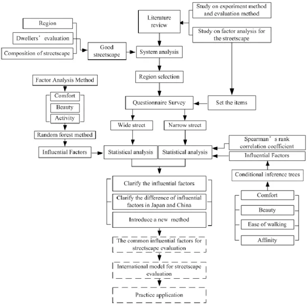
In order to make a clear understanding of the study, the technology route of the research framework is presented is Figure 1.1.
7
Chapter 2 Literature Review
In this chapter, we sort out the existing research on the streetscape evaluation. The existing research is organized into research on the factors analysis, experiment method and evaluation method with the goal of streetscape evaluation these three aspects.
2.1 Study in the streetscape constituent factors
Previous research has suggested that the analysis of streetscape factors plays an important role in the streetscape evaluation. Hitherto, massive research results in the field of streetscape factors analysis have been accumulated.
2.1.1 Streetscape evaluation based on SD method
The semantic differential (SD) method is now one of the most widely used scales used in measuring the connotative meaning of things and concepts. It measures people’s reactions to stimulus words and concepts in terms of rating on bipolar scales defined with contrasting adjectives at each end (Summers, 1970). The bipolar adjective pairs can be used for a wide variety of subjects.
In the field of streetscape evaluation, the SD method is used to analyse the influential factors in numerous studies. In common, the research approach is, setting the streetscape as the object, using the onsite survey, slide show, CG images or montage to show the object to the respondent, then analysing the potential evaluation factors-comprehensive evaluation factors such as comfort, activity, beauty, prosperity via the SD method and factor analysis method.
In China, the studies in the streetscape evaluation are remains at the phenomenon description level. Few are quantitative researches. Till recent years, SD method began to be applied to the study of the streetscape. Wang and Zhang (2011) select eight representative streets in Shanghai city and 36 students as respondents in which half are architecture majors. 4 groups (the shape of the street space, atmosphere, characteristics, and street environment) composed by 20 bipolar adjective pairs are adopted to survey the space perception via the SD method. Then construct the relevant analysis between 4 perceptions and 9 objective indexes of every street. The research reveals that the street length influences the perception most.
8
In Japan, a large number of scholars have conducted research in this area. As early as the 1970s, Kitamura (1976) gave more details on the application of the SD method. Shinichi K. selects 11 bipolar adjective pairs ‘beautiful- ugly’, ‘orderly-messy’, ‘clean-dirty’, ‘bustling-deserted’, ‘active-hushed’, ‘human-like-no human-like’, ‘like-dislike’, ‘charming-dull’, ‘easy to be familiar with- hard to be familiar with’, ‘calm-restless’, ‘feel the warmth-feel the coldness’ based on the SD method, and obtains ‘harmony’, ‘activity’, ‘affinity’ these three common factors by factor analysis. The relationship between spatial factors and indexes is surveyed via multiple regression method. The results show that ‘harmony’ trends to be affected by the height of building, colour, texture, variety of the texture, quantity of the nature, and quantity of the billboards. ‘Activity’ maybe affected by the number of pedestrian, quantity of billboards, colour and the variety of the texture. And it is possible that ‘affinity’ is affected by the amount of nature, texture, colour, the variety of colour, the variety of texture and the height of building.
Funakoshi and Tsumita (1987) carry out a correlation test at five shopping streets and five residential streets by the use of 13 bipolar adjective pairs which are classified into such psychological factors as design factor, urbanity factor, openness factor and so on. The correlation coefficients between 13 psychological factors and 21 space elements at the shopping streets and 15 space elements at the residential streets, respectively, are calculated on the basis of the correlation test data and physical analysis data. Moreover relations among space elements on the street spaces are made clear with the cluster analysis method on the correlation coefficients. At last 26 estimate formulas are obtained by the multiple regression analysis method with psychological factors as independent variables and space elements as dependent variables. As a result of the analyses, relations between psychological factors and space elements on the street spaces can be explicated qualitatively and quantitatively. In conclusion, sidewalks, trees and shrubberies along the streets and pedestrian buffer spaces between sidewalks and buildings are very important elements and can be enhance the enjoyment, quality of space, openness and atmosphere on the street spaces. Utility poles, signposts and street installations disturb the unity, composure and continuity on the street spaces, etc.
9
By paying attention to disorder/order of streetscapes, Matsumoto et al. (1991) evaluate streetscapes using a factor analysis method. Three factors— “passive capacity,” “tradition and disorder,” and “activity” are derived. At last, the following results are got. Disorder is decided by distribution form and impression of disorderly elements. Regularity is influenced by physical situations of not only regular ones but also disorderly ones. Disorder and regularity in street views are decided by mutuality of physical situations of individual elements.
Maki (2006) assesses the influence of “fatigue” on streetscape evaluation. In the experiment, 24 streetscape slides are rated before and after the two hours VDT (Video Display Terminal) task to clarify whether fatigue mediates the streetscape evaluation and whether fatigability can explain the individual difference observed during the evaluation. Together with the quantitative evaluation on fatigue, SD method based streetscape evaluation is also constructed. Thus obtained evaluation scores are analysed by principal component analysis. According to the ratings obtained before and after the VDT task, it has been pointed out that people who get easily tired by fatigue experiments tend to like nostalgic scenery after work, whereas people who do not tire easily tend to dislike urban sceneries and pedestrian traffic.
Amano et al. (2010) apply covariance structure analysis to the streetscape SD method and points out that “the ease of walking” and “atmosphere” affects the pleasure derived from streetscapes. The desire to return to streetscapes was also considered in his research.
2.1.2 Multi-factors
Yang et al. (2012a, b) investigate the factors of identification on streetscape, and clarify the relationship between streetscape identification and sensitivity evaluation. In the psychological experiment, the streetscape of Chengdu, China has been set as an object of the study. They select 32 students as respondents to classify the 120 sheets of typical streetscape images by operating the method of binary tree classification 3 times. At the same time the degree of satisfaction of those streetscapes from ‘comfort’ and ‘activity’ these two factors are evaluated by using five-stage method. Three factors ‘the width of sidewalk’, ‘the presence of shops’ and ‘the quality of the pavement’ are found to be the influential factors on
10
identification. It also reveals that the quality of the pavement is a significant impact on the comfort of streetscape. The width of a sidewalk is shown to have a large effect on streetscape’s comfort and range of activities. Moreover, although the “existence of shops” had a positive influence on the range of activities, it gives a negative image to the comfort of streetscapes. Furthermore, it is found that surface of sidewalks has a strong influence on its comfort.
Oku (1985) reports on the influence of townscape elements on the estimation of townscape by means of the montaged slide. He evaluates ‘unity’, ‘intimacy’, and ‘preference’ by rating the retouched photographs from elements such as top of buildings (skyline), trees, arcade, windows, surface of road, landmark, billboard, utility poles and overhead wires. The research suggests that the higher a degree of unity becomes, the higher a degree of intimacy and preference become, but if a degree of unity becomes too high, a degree of intimacy and preference will be reduced.
Fujii and Kurita (2010) conduct a study on landscape evaluation of the approach to temple in the central commercial area of temple town. In their research, they consider the effect of landscape elements on landscape evaluation by analysing the structure of landscape evaluation with covariance structure analysis. The following conclusions are obtained. Utility among local residents increased due to the minimization of signboards, regulation of building heights, increasing the number of trees along the streets, and prohibiting advertisement in bus shelters in improvements of the landscape along the approach to the temple. Residents have various reactions to the regulation of building heights. Reducing the number of signboards meets with general agreement. That reduction in the number of signboards and building height limits has the effect of raising the comprehensive landscape evaluation, while an increase in signage has the opposite effect.
2.1.3 Single factor
Nemoto (1985) develops a new planning method that makes street scenes in a residential area beautiful and comfortable with green. The research focuses on the greenery. First, they make a psychological experiment using the SD method with a lot of montage slides.
11
Secondly, two indexes ‘visibility ratio of street trees’ and ‘load side planting ratio’ are defined and these two indexes are analysed via multi regression analysis. As a result, it reveals that people need green visibility ratio about 25%, and load side planting ratio can be calculated according to green visibility ratio.
Aoki (1989) focuses the research on the greenery massive impression. In the experiment, 20 typical streets in 23 wards of Tokyo are selected. 10 respondents are required to rate the massive impression of greenery onsite. After interviewing the respondents, the criterion for rating is obtained. By differentiating the street space, the result that greenery massive impression is not only connected with greenery occupancy ratio but also connected with the variation of the greenery occupancy ratio is obtained.
Matsukawa et al. (1993) analyse the extent of the visual range on streets in urban area using 3-dimensional simulation model. In their research, visual range is defined as the rate of interrupted sky. And this index of each selected street is calculated for various simulation patterns using 3-dimentional buildings data of Oita city.
Zhang et al. (2005) discuss the heights of buildings lining Nandajie Street in Xi’an China. The heights of the buildings are changed in each influenced range of streetscape. By clarifying the influences of the streetscapes developed from the combinations on men’s psychological evaluation, the estimation is performed for desirable combination of the heights of the buildings. In order to achieve the examinee’s feeling as real as possible, VR (Virtual Reality) system is adopted in the evaluation experiment.
Kita et al. (1999) clarify relationships between estimation and color composition in streetscapes regarding the range of basic and point colors in a collection of building walls.
2.2 Experimental method
After reviewing the existing researches, we can find that when exploring the streetscape, psychological evaluation is often conducted at first. In order to obtain the more accurate data, how to show the streetscape to the subjects as real as possible becomes important. Next, we want to get some details about the experimental method to streetscape evaluation.
12
2.2.1 CG, montage, video
In amount of research, we can find that slide is often used to show to the subjects with CG (computer graphics), montage, and video.
Nishio et al. (1999) conduct the psychological experiment to discuss landscape from the viewpoint of environmental engineering. Seventy two slides of streetscape are shown to the subjects in the experimental chamber adjusted to two levels of traffic noise, vegetation (with or without vegetation) and temperature (26℃, 28℃). Evaluation is made on 17 pairs of adjectives of seven point scales. Subjects are 25 healthy male students, half of whom specialised in architectural course. Result shows that the evaluation structures of the two subject groups differs each other in the evaluation of vegetation.
In the research of Endo and Yamada (2008), evaluation experiment of SD method is conducted by on-site and using slide aimed to verify the validity of the using slide evaluation method when evaluating psychological effect by roadside trees. From the result of factor analysis of each evaluation experiment result, psychological, view, spatial evaluation factor is extracted, and evaluation structure of roadside trees is no big difference in each methods. Moreover, from the result of cluster analysis by using factor score of psychological and view evaluation factor, the evaluation result of each method is brought together in the same cluster on most streets, and it is suggested that validity of using slide evaluation method is high. Because it is not possible to evaluate factors accurately from the slide such as the existence of living things, street information on pavement width and tree height, the difference in each method is seen on a part of street.
Tajima and Asakura (1985) compare the evaluations on the streetscapes presented by different method and analyse the influences each presentation has to change the evaluation on the streetscape. They make some experiments for evaluations on streetscapes using by SD method and eye mark recorder (EMR). And find that videotape recorder (VTR) is an effective method to present streetscapes.
Kagawa et al. (2009) analyse the influences on attractive information elements such as signboards by using pictures of 8 streets in Jiyuugaoka shopping area, three variables namely
13
‘the ratio of disordered area’, ‘the ration of stimulatingly-colored area’ and ‘the ratio of calmingly ’.
Mitsuhashi (1992) aims to develop a quantitative evaluation method of townscape by applying landscape simulation to the modelized urban scape. Practically, a 3D model of the urban space is input as data. Buildings are projected to a cylinder which has the view point as its center. At the same time, distance and angle between the view point and the projected object is measured. According to the resultant data, the buildings are evaluated from their potential abilities to become landmarks.
Hirate and Yasuoka (1986) make experiments on measurement of psychological quantity with using photomontage slide films of street-vistas and introducing of a new structural model of psychological evaluation. The possibility that psychological quantity is connected to simple physical quantity is shown. The objects in experiment are black and white photomontage slide films. After obstructive elements (i.e. utility poles, billboards, and original roadside trees etc.) retouched, roadside trees are montaged. Experiments are made into two parts. At part 1, backgrounds, trees, planting arrangements on the objects are changed and in part 2, width of road and planting arrangements, too. At last, the best width and best interval of planting are obtained.
2.2.2 Pilot experiment
A pilot experiment, also called a pilot study, is a small scale preliminary study conducted in order to evaluate feasibility, time, cost, adverse events, and effect size (statistical variability) in an attempt to predict an appropriate sample size and improve upon the study design prior to performance of a full-scale research project (Hulley, 2006). In reseat years, this method has been used in streetscape evaluation widely.
Amano et al. (2010) think that landscape is influenced by various behaviours of those who are connected with that place and the essential method to improve landscape should be to lead their attitude modification on landscape. Their research is an examination of the possibilities that their attitude modification on landscape lead a landscape-improvement through a social experiment that is one of the psychological strategies. The results indicate
14
that behaviours of shop keepers lead modification of pedestrian impression on streetscape and attitude change of shop keepers. The result reveals that an induction of attitude modification is effective against a landscape-improvement.
In order to understand the problems for making better use of the public space in the future, Watanabe et al. (2001) report an experiment for activating the city center by ‘Citizens Forum on Urban Design ’ in Chiba City. In this study, they analyse two points from the process. The first is the necessary conditions permitting the use of public space and the second is the effect on urban design. The results are shown as follows. It is the important condition that the projects has ‘Public interest’ which is shown as ‘participation of administration’ for use of public space and the experiment succeeds in making ‘the public life scene’.
2.3 Statistical method
The statistics plays a decisive role in streetscape evaluation.Fujii and Sakai (2002) examine the causal relationship between the physical measurements on landscape elements and the subjective-psychological judgement on landscape evaluation with two analytical methods, namely the conjoint analysis which has the availability deciding the utility of each landscape element and the covariance structure model which has the capability of flexibly forming the model. In their study, they select five landscape element of the streetscape as attributes, make eight landscape images by means of combining levels of five landscape elements using the image processing, and carry out the evaluation experiment of streetscape. As a result, the availability and usefulness of each analytical method are confirmed.
Maki et al. (2003) propose a streetscape evaluation structural model named Card Pick up model. This model has three remarkable points which are different from the linear combination model which has been most popular model of evaluation structure.
1. The meaning of constructs expressed on four levels, ‘influence over evaluation’, ‘character’, ‘situation’ and ‘cognitive’
2. The constructs being used for evaluation change dynamically depending on the feature of the streetscape
15
preference.
In the research of Yang et al. (2012a), multivariate regression tree is employed to process and analyse the identification data which is collected by the result of image classification. As a result, the width of sidewalk, the presence of shops, and the quality of the pavement are found to be the influential factors on identification. And it is also reveal that the quality of the pavement is a significant impact on the comfort of streetscape. Yang et al (2012b) conduct another study on cognitive structure of streetscape in Chengdu China by multivariate adaptive regression spline (MARS) and obtain the physical factor which affects the degree of satisfaction of a streetscape.
2.4 Trends of papers on the evaluation of landscape
Papers of landscape appreciation began to be published in the decade of the 1960s. Till now, this subject, psychological evaluation of landscape, has spread into wider scientific research field. In order to provide information to newcomers of this research, many scholars try to summarize the works.
Aoki (2007) summarizes recent trends of English papers on the psychological evaluation of landscape. The paper reviews recent interesting studies in terms of psychological tests referred to in Environment and Behaviour, J. of Environmental Management, Landscape and Urban Planning, Landscape Journal, Landscape Research, and some other scientific journals from 1996 to 2005, and summarizes those papers according to the key subjects, i.e., the effects of respondents’ attributes, the descriptors of appreciation, the sampling of landscapes and their presentation methods, the predictive model of psychological response using the physical features for physical planning, and others.
Li et al. (2011) take research articles published in various societies and magazines in Japan during fifty years from 1960 to 2010 as subjects, and make two genealogical tables aimed at counting publishing units. Based on the mastery of previous researches, the paper analyzes and forecasts the trends of research on road landscape. Finally, one hundred and forty papers during fifty years are classified and the development history of researches on road landscape in Japan is concluded. The paper helps grasp the latest research trends and determine the
16
necessary research methods which should be adopted when evaluating road landscape in future.
Coeterier (1996) focuses on the perceptual attributes and physical elements and refers to 70 papers. Aoki (1999) overviews the entire procedure of the experiment and refers to 73 papers. Palmer and Hoffman (2001) focus on reliability and representation validity and refer to 71 papers.
2.5 Summary
2.5.1 Outline of existing research
Figure 2.1 shows the outline of the existing research. As can be seen from the figure, there are four kinds of streetscape evaluation image, first-hand experienced streetscape via on-site experiment, actual photographed image, virtual space image by computer graphics (CG), and montage image composited by CG or other images in the captured image. In particular, with the CG image and montage image, factor is easy to be controlled comparatively. Method of evaluation experiment on streetscape is divided into two types, SD method based on cognitive evaluation and cognitive classification. Because the primary goal of the cognitive classification is to classify common characteristics according to type, the subsequent statistical analysis method is limited. On the other hand, since the goal of the experiment by the SD method covers a wide range, various statistical analyses can be used.
According to the presence of the external criterion, the selection of statistical analysis method is different. Factor analysis, principle component analysis, and latent structure analysis are often used to explore the latent structure of streetscape evaluation. When survey the impact of spatial characteristics, multiple regression analysis, canonical correlation analysis, hayashi’s quantification methods I, classification and regression tree (CART), and multivariate adaptive regression spline are frequently adopted. Cluster analysis, especially the hierarchical cluster analysis is used in streetscape image classification. At the same time, multidimensional scaling and correspondence analysis are graphical techniques. They are designed to reduce dimensionality and portray relationships among observations or variables and often used before the cluster analysis to provide classification basis for cluster
17
classification.
Figure 2. 1 Outline of the existing researches 2.5.2 Deficiency of existing research
When pay attention to streetscape image used for an experiment, in many studies, dozens of pieces of streetscape images are used. However, the real street scene covers wide range, it cannot be said that is enough numbers to examine those influence closely. Therefore, in the articles that mentioned in 2.2.1 section, the spatial factor that is considered to affect the evaluation is controlled by making CG image and montage image. However, it does not actually exist and has no objective reality. It is thought has not much effect to the experimental results, such as SD method. If large numbers of images are shown to test subjects for evaluation, it is probable that it not only costs a great deal of labour but also fatigues test subjects. Therefore, when the method comprising evaluating many images is adopted, some measures to eliminate external factors for subjects such as ‘fatigue’ are required.
18
Regarding the statistical method for streetscape evaluation, principle component analysis or factor analysis is used to explore latent structure after rating the streetscape images by SD method. Multiple regression analysis is often used under the presence of external criterion. Sakai and Fujii (2002) point out that among the sensitivity data, if there is an external criterion, the relationship between the explanatory variables and responses is often the non-liner. As a result, the classification and regression tree has been extensively used in the literature. However, this method has a significant limitation, low prediction accuracy. Therefore, the exploration of statistical model that can be interpreted easily and superior in the prediction accuracy is necessary.
Regarding the international comparisons research, Shidei (1981) compares the attitudes toward nature among Japan, France, and Germany. Aoki and Petrova (2010) conduct a comparison of natural landscape appreciation between Russia and Japan. However, no attempt has been made to identify factors influencing streetscape evaluation internationally. In the streetscape evaluation, in order to obtain the common points and absorb experience and new ideas, the international comparison on the streetscape evaluation via the same method is extremely important.
19
Chapter 3 Study design
3.1 Subject region for questionnaire
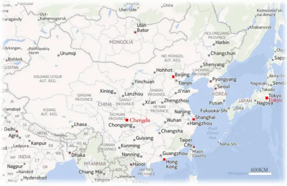
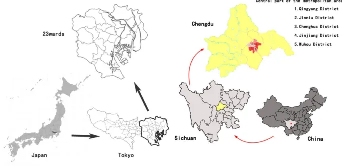
Tokyo Japan and Chengdu China are selected as the target areas for this survey. Tokyo, officially Tokyo Metropolis is one of the 47 prefectures of Japan. Tokyo is the capital of Japan, the center of the Greater Tokyo Area, and the largest metropolitan area in the word (United Nations, 2009). Chengdu is the capital of Sichuan Province, which is known as the "Heavenly State" (Tian Fu Zhi Guo). Being the natural habitat of cute giant pandas, it is located in the west of Sichuan Basin and in the center of Chengdu Plain. Subsequently, Tokyo and Chengdu will be introduced briefly. The relative location of Tokyo and Chengdu is shown in figure 3.1.
Figure 3. 1 Relative location of Tokyo and Chengdu
3.1.1 Brief introduction of Tokyo city
With a population of about 13 million, Tokyo has grown into the largest of the 47 prefectures of Japan and indeed one of the greatest metropolises in the world. Comprising 23 special wards, 26 cities, 5 towns, and 8 villages, Tokyo is the center of various activities in Japan
20
including politics, economy, and culture.
1. History
Tokyo was originally a small fishing village named Edo. Edo was first fortified by the Edo clan, in the late twelfth century. In 1590, Tokugawa Ieyasu made Edo his base and when he became shogun in 1603, the town became the center of his nationwide military government. During the subsequent Edo period, Edo grew into one of the largest cities in the world with a population topping one million by the 18th century. Tokyo became the de facto capital of Japan even while the emperor lived in Kyoto, the imperial capital (Sorensen, 2002).
2. Climate
The majority of mainland Tokyo lies in the humid subtropical climate zone, with hot humid summers and generally mild winters with cool spells (Peel et al. 2007). The region experiences a one-month seasonal lag, with the warmest month being August, and the coolest month being January. Annual rainfall averages nearly 1530 millimeters, with a wetter summer and a drier winter. Snowfall is sporadic, but does occur almost annually.
3. Geographical distribution of industrial development
Tokyo is a major international finance center, houses the headquarters of several of the world's largest investment banks and insurance companies, and serves as a hub for Japan's transportation, publishing, and broadcasting industries. During the centralized growth of Japan's economy following World War II, many large firms moved their headquarters from cities to Tokyo, in an attempt to take advantage of better access to the government. This trend has begun to slow due to ongoing population growth in Tokyo and the high cost of living there. The Tokyo Stock Exchange is Japan's largest stock exchange, and third largest in the world by market capitalization and fourth largest by share turnover (Horticulture statistics team, 2003). Tourism in Tokyo is also a contributor to the economy.
4. Cityscape
Architecture in Tokyo has largely been shaped by Tokyo's history. Twice in recent history has the metropolis been left in ruins: first in the 1923 Great Kanto earthquake and later the extensive firebombing in World War II. Because of this, Tokyo's urban landscape consists
21
mainly of modern and contemporary architecture, and older buildings are scarce (Hidenobu, 1995). Tokyo features many internationally famous forms of modern architecture including Tokyo International Forum, Asahi Beer Hall, Mode Gakuen Cocoon Tower, NTT Docomo Yoyogi Building and Rainbow Bridge. Tokyo also features two distinctive towers: Tokyo Tower and the new Tokyo Skytree which is the tallest tower in Japan and the second tallest structure in the world.
Tokyo also contains numerous parks, shrines, Buddhist temples, Japanese gardens, historical buildings, and related museum. . There are four national parks in Tokyo Prefecture, including the Fuji-Hakone-Izu National Park, which includes all of the Izu Islands. The world’s tallest freestanding broadcasting tower Tokyo Sky tree are just a few examples of sightseeing spots full of history and tradition.
5. Population and density
The densely inhabited district in great Tokyo area is shown in figure 3.2 with the source from Ministry of Land, Infrastructure, Transport and Tourism (MLIT).
Figure 3. 2 Densely inhabited district (DID) in Great Tokyo Area
22
Districts (DID) refers to statistical districts in Japan set in the population census. They are districts which are composed of groups of contiguous population census enumeration districts each of which has a population density of more than 4,000 inhabitants per square kilometer, and the combined population of the contiguous districts exceeds 5,000. However, highly urbanized enumeration districts such as airports, seaports, industrial districts and parks are also included among densely inhabited districts even with small population density. They are used as standards classifying urbanized areas and rural areas and indicating the sizes of urban areas in a narrow sense.
In the figure, the red line is the boundary between prefectures. The dark blue area is approximate to the 23 wards in Tokyo prefecture. By the population census data in 2005, that the population in Japan is 127 million, and the population and the DID population in great Tokyo area (Tokyo, Chiba, Saitama, and Kanagawa) is 38.7 million and 34 million respectively is obtained .According to the definition of DID, we can get a conclusion that there are one- third persons in Japan live in great Tokyo area, and most of the population gathers in the central part of Tokyo.
3.1.2 Brief introduction of Chengdu city
Chengdu is one of the most important economic, transportation, and communication centers in Western China. According to the 2007 Public Appraisal for Best Chinese Cities for Investment, Chengdu was chosen as one of the top ten cities to invest in out of a total of 280 urban canters in China. In 2006, it was named China's 4th-most liveable city by China Daily (Jing, 2006).
1 History
The history of the city can be traced back 2400 years when the first emperor built his capital here and named the city. Through thousands of years its original name has been kept and its position as the capital and as the significant center of politics, commerce and military of the Sichuan area (once called Shu) has remained unchanged. Since the Han (206B.C.-220) and Tang (618-907) Dynasties when its handicraft industry flourished, the place has been famous for its brocades and embroideries. The city was also the place where the bronze culture, an
23
indispensable part of ancient Chinese culture, originated.
2 Climate
Chengdu has a monsoon influenced humid subtropical climate and is largely mild and humid. It has four distinct seasons, blessed with abundant rainfall, and relieved from both sweltering summers and freezing winters. The summer is hot and humid. Rainfall is common year-round but is the greatest in July and August, with very little of it in the cooler months. Snow is rare but there are a few periods of frost each winter.
3 Geographical distribution of industrial development
China's state council has designated Chengdu as the country's western center of logistics, commerce, finance, science and technology, as well as a hub of transportation and communication. It is also an important base for manufacturing and agriculture.
Medical facilities distribution Commercial facilities distribution High education institute distribution
Accommodation distribution Government house distribution Distribution of combination Figure 3. 3 Distribution of various main facilities
24
main facilities are concentrated in the city centre.
4 Cityscape
Because of the long history and splendid culture, Chengdu features historic places of interest such as the Thatched Cottage of Du Fu, Wuhou Memorial Temple and Wenshu Monastery etc.
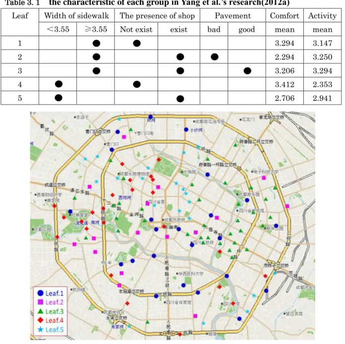
Table 3. 1 the characteristic of each group in Yang et al.’s research(2012a)
Leaf Width of sidewalk The presence of shop Pavement Comfort Activity <3.55 ≥3.55 Not exist exist bad good mean mean
1 3.294 3.147
2 2.294 3.250
3 3.206 3.294
4 3.412 2.353
5 2.706 2.941
Figure 3. 4 the distribution of each group in Yang et al.’s research (2012a)
Regarding the streetscape in Chengdu city, we can get some hints from Yang et al.’s research. The data shown in Figure 3.4 and Table 3.1 is the result of sidewalk landscape researched by
25
Yang et al. (2012a). It is clear from figure 3.4 and table 3.1 that the streets in the northwest of Chengdu is in low activity with narrow sidewalk and the streets in the north of Chengdu is not comfortable also with the narrow sidewalk. At the same time, that the active and comfortable sidewalks mainly exist in the east and central part of Chengdu can be revealed.
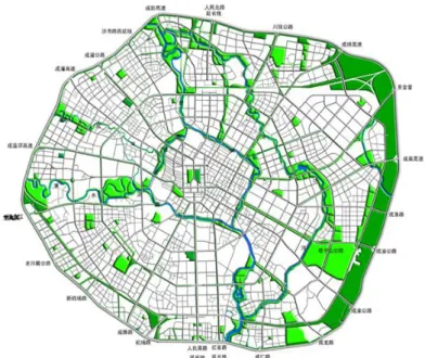
Figure 3.5 is indicative of distribution of green area in Chengdu. As can be seen from the figure, the greenery is mainly concentrated in the eastern.
Figure 3. 5 the distribution of green area in Chengdu city
5 Population and density
Chengdu prefecture covers a total area of 12.121 thousand square kilometers with a population of over 14 million. According to the sixth national population census of the People’s Republic of China conducted in 2010, the urban area of Chengdu houses 14,047,625 permanent inhabitants: 7,123,697 within the municipality's nine districts and 6,730,749 in the surrounding region. The population density in Chengdu city is 1159 persons per square kilometer, but in the 5 central districts, the density extremely increases to 11419 persons per square kilometer.
3.1.3 Comparison of two cities
The survey regions are 23 wards in Tokyo city and 5 centre districts in Chengdu city. The location of these regions can be seen in figure 3.6.
26
location of survey region in Tokyo city location of survey region in Chengdu city
Figure 3. 6 Location of survey region in two cities
The reasons for selecting these places are as follows. Chengdu is the two-thousand year old provincial capital of Sichuan province. Similar to other cities in China, there has been a rapid increase in the number of vehicles. In the central part, famous places like Wuhou Memorial temple, Dufu Thatched Cottage, Qingyang temple, which are dotted with historic sites, have also become into one of the major tourism industry. In such areas, the street maintenance overemphasized only in efficiency has a possibility of altering not only the streetscape but also the street. On that account, development with the landscape consideration is required. Thus, also in China, especially Chengdu must perform the street maintenance which noted the street landscape.
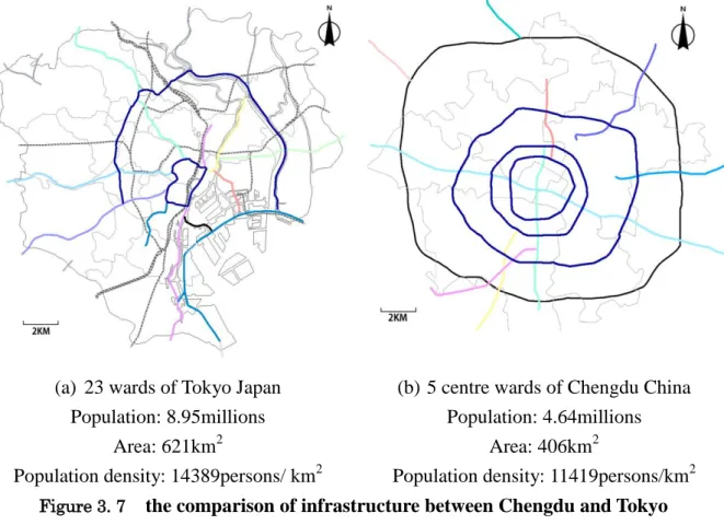
In addition, the central part of Chengdu city has a population of approximately 5 million, with a population density of 11419 persons per square kilometers. The only city in Japan with an equivalent population to Chengdu is Tokyo (with about 8.95 million people in Tokyo’s 23 wards). Tokyo is the capital of Japan and has been termed as the centre of industry and has the largest economy in Japan. It not only features very high population density, but also suffers from chronic traffic congestion. What is more, the forms of transportation infrastructure in urban areas are similar between Tokyo and Chengdu. A comparison of figure 3.7 (a) and (b) shows that. The road infrastructure of Chengdu is
27
annular with three circular routes. And there is a horizontal main avenue and vertical main road passing through Tianfu square which is located in the centre of Chengdu. Although not perfect, the transportation infrastructure form of Chengdu’s central city is similar to the form of Tokyo’s inner circular route and central circular route. Besides that, the form of road infrastructure from center toward the outside in Chengdu is similar to the form of Route 1( the Tokyo Metropolitan Expressway) and Route2(the Tokyo Metropolitan Expressway) In a word, the reason that the similarities in the population and transportation infrastructure form between Chengdu and Tokyo motivated to compare Chengdu and Tokyo.
(a) 23 wards of Tokyo Japan (b) 5 centre wards of Chengdu China Population: 8.95millions Population: 4.64millions
Area: 621km2 Area: 406km2
Population density: 14389persons/ km2 Population density: 11419persons/km2
Figure 3. 7 the comparison of infrastructure between Chengdu and Tokyo
3.1.4 Classification of the street
Generally speaking, street can be classified to 3 types by function, primary distributers, district distributers, and local distributers. The main function of these streets is listed below. (1) Primary distributer:
Provide for major regional and inter-regional traffic movement and carry large volumes of generally fast moving traffic
28
(2) District distributer
Carry traffic between industrial, commercial and residential areas and generally connect to primary distributors
(3) Local distributer
Carry traffic within a cell and link district distributers to access roads
According to the figure 3.8, we can find that in Tokyo and Chengdu city, streets can not only provide the traffic function but also the communication between city dwellers. And it is obvious that the main function of the primary distributers and district distributers is focused on the traffic while the local distributer is mainly emphasized on the community. As a result, in this research, we decide to classify the streets, and survey the streetscape from wide street (primary distributers and district distributers), and narrow street (local distributer) respectively.
Wide street in Tokyo Narrow street in Tokyo
Wide street in Chengdu Narrow street in Chengdu
29
3.2 Formation of the questionnaire
The question in the questionnaire is graded on a five-grade evaluation scale based on the SD method. After examining the connotative meaning of hundreds of items occurred in the previous researches, we identified two major dimensions: streetscape evaluation, and
physical situation. The scale is set up using polar adjectives (opposite-meaning terms) at
each end. The respondents are asked to rate a streetscape, by putting a mark on one of the 5 spaces along each dimension. In order to obtain the high accurate data, we draw up the questionnaire by a criteria listed below.
1. To avoid fatigue or boring the respondent, do not use more than 30 lines. Using fewer is acceptable.
2. The location of the positive attributes should be varied from left to right. Do not put all the ‘good’ adjectives on one side, as it might bias the responses.
3. If the questionnaire is conducted with many respondents at once, reverse the items’order of part of the questionnaires.
4. Provide clear instructions for the respondent so that they put their marks in the right place.
The survey required respondents to think about the most impressive wide road and narrow road they knew in their respective cities and fill in the questionnaire accordingly. The locations of the positive attributes are exchanged in turn in different items to avoid putting all the ‘good’ adjectives on one side, and the locations of items are also changed in different questionnaire paper. At the same time, the maps of survey regions are attached to the questionnaire to avoid the confusion. The sample of the questionnaire can be seen in the appendices. The introduction on the questionnaire of primary and district distributor road and the questionnaire of local distributor road will follow shortly.
3.2.1 Questionnaire of primary and district distributor road
Impressive primary distributor road and district distributor road, with sidewalks and more than 3 lanes, are focused upon here. Dozens of adjective pairs were selected in primary stage. In order to avoid fatigue or boring the respondent, the adjective pairs were reduced to 21