10.1
解析ツール ... 1 オーバーレイ ... 1 抽出 ... 1 統計 ... 1 近接 ... 1 カートグラフィ ツール ... 1 アノテーション ... 1 カートグラフィックの調整 ... 2 シンボル表現の競合 ... 2 ジェネラライズ ... 2 データドリブンページ ... 2 マスク ツール ... 3 リプレゼンテーション管理 ... 3 格子線と経緯線 ... 3 変換ツール ... 3 CAD へ変換 ... 3 COLLADA へ変換 ... 3 dBASE へ変換 ... 3 GPS から変換 ... 3 KML から変換 ... 3 KML へ変換 ... 4 WFS から変換 ... 4 カバレッジへ変換 ... 4 シェープファイルへ変換 ... 4 ジオデータベースへ変換 ... 4 メタデータ ... 4 ラスタから変換 ... 5 ラスタへ変換 ... 5 データ管理ツール ... 5 LAS データセット ... 5 Tile Cache ... 6 アタッチメント ... 6 インデックス ... 6 グラフ ... 6 サブタイプ ... 6
ジオデータベース管理 ... 6 ジオメトリック ネットワーク ... 7 テーブル ... 7 テーブル結合 ... 7 データ比較 ... 8 トポロジ ... 8 ドメイン ... 8 バージョン ... 8 パッケージ ... 9 ファイル ジオデータベース ... 9 フィーチャ ... 9 フィーチャクラス ... 10 フィールド ... 10 ラスタ – モザイク データセット ... 11 ラスタ – ラスタ カタログ ... 11 ラスタ – ラスタ データセット... 12 ラスタ – ラスタ プロセシング... 12 ラスタ – ラスタ プロパティ ... 12 リレーションシップ クラス ... 13 レイヤとテーブル ビュー ... 13 ワークスペース ... 13 一般 ... 13 写真 ... 14 分散ジオデータベース ... 14 投影変換と座標変換 ... 14 投影変換と座標変換 – フィーチャ ... 15 投影変換と座標変換 – ラスタ ... 15 リニア リファレンス ツール ... 15 マルチディメンション ツール ... 15 サーバ ツール ... 16 キャッシュ ... 16 データの抽出 ... 16 公開 ... 16 印刷 ... 17 空間統計ツール ... 17 クラスタ分析のマッピング ... 17 パターン分析 ... 17
... 17 ... 17 空間関係のモデリング ... 18 モバイル ツール ... 18 カバレッジ ツール ... 18 データ管理 – アイテム ... 18 データ管理 – インデックス ... 18 データ管理 – コンポジット フィーチャ ... 18 データ管理 – ジェネラライズ ... 18 データ管理 – テーブル ... 19 データ管理 – トポロジ ... 19 データ管理 – ワークスペースの管理... 19 データ管理 – 投影変換 ... 19 データ管理 – 集約 ... 19 データ管理 – テーブル結合 ... 19 データ管理 – 許容値 ... 19 変換 – カバレッジからの変換 ... 19 変換 – カバレッジへ変換 ... 20 解析 – オーバーレイ ... 20 解析 – 抽出 ... 20 解析 – 近接 ... 20 ジオコーディング ツール ... 20 編集ツール ... 21 パーセル ファブリック ツール ... 21 データ移行 ... 21 パーセル フィーチャ ... 21 レイヤとテーブル ビュー ... 21 変換ツール(国内データ) ... 21 DM ... 21 G-XML ... 21 SIMA ... 22 SXF Ver.3.0 ... 22 2000 ... 22 ... 22 サマリ ... 22
Basic
Standard
Advanced
Identity Update Erase Intersect Symmetrical Difference Union Spatial Join Clip Split Table Select Select Tabulate Intersection Summary Statistics FrequencyCreate Thiessen Polygons
Buffer
Point Distance
Polygon Neighbors
Multiple Ring Buffer Near
Generate Near Table
10 10 21
Basic
Standard
Advanced
Contour Annotation
Map Server Cache Tiling Scheme To Polygons
Create Underpass Create Overpass
Align Marker To Stroke Or Fill
Calculate Polygon Main Angle
Disperse Markers Calculate Line Caps
Set Representation Control Point At Intersect
Set Representation Control Point By Angle
Detect Graphic Conflict
Resolve Building Conflicts Propagate Displacement
Resolve Road Conflicts
Create Cartographic Partitions
Aggregate Points Smooth Polygon Simplify Polygon Aggregate Polygons Smooth Line Simplify Line
Collapse Dual Lines To Centerline
Simplify Building
Delineate Built-Up Areas
Merge Divided Roads Collapse Road Detail
Thin Road Network
UTM Calculate UTM Zone
Strip Map Index Features
Calculate Grid Convergence Angle
Calculate Central Meridian and Parallels Calculate Adjacent Fields
Intersecting Layers Masks
Cul-To-Sac Masks
Feature Outline Masks
Select Feature By Override
Update Override
Remove Override
Calculate Representation Rule
Drop Representation
Add Representation
Set Layer Representation
Make Grids and Graticules Layer
Delete Grids and Graticules
9 24 46
Basic
Standard
Advanced
CAD
CAD Export To CAD
CAD Add CAD Fields
COLLADA
→ COLLADA Multipatch To Collada dBASE
dBASE Table To dBASE Multiple
GPS New!
GPX GPX To Features
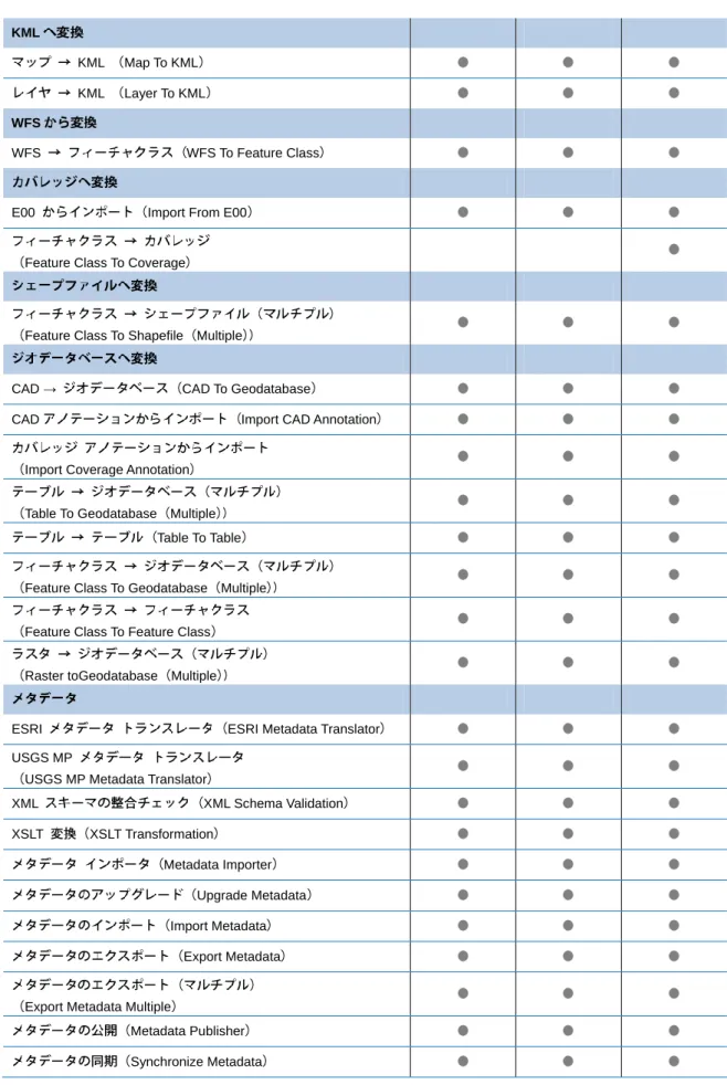
KML
KML
KML Map To KML KML Layer To KML
WFS
WFS WFS To Feature Class
E00 Import From E00
Feature Class To Coverage
Feature Class To Shapefile Multiple
CAD → CAD To Geodatabase
CAD Import CAD Annotation
Import Coverage Annotation
Table To Geodatabase Multiple Table To Table
Feature Class To Geodatabase Multiple
Feature Class To Feature Class
Raster toGeodatabase Multiple
ESRI ESRI Metadata Translator
USGS MP
USGS MP Metadata Translator
XML XML Schema Validation XSLT XSLT Transformation Metadata Importer Upgrade Metadata Import Metadata Export Metadata
Export Metadata Multiple
Metadata Publisher
1
ArcGIS Spatial Analyst ArcGIS 3D Analyst Validate Metadata
Validate Metadata Multiple
ASCII Raster To ASCII
→ Raster To Video
Raster To Point
Raster To Polygon
Raster To Polyline
.flt Raster To Float
ASCII ASCII To Raster
DEM DEM To Raster
LAS (LAS Dataset to Raster)
Feature To Raster
Point To Raster 1 Polygon To Raster 1
Polyline To Raster 1
Raster To Other Format multiple
.flt Float To Raster
46 47 48
Basic
Standard
Advanced
LAS New!
LAS
Remove Files from LAS Dataset LAS
Add Files to LAS Dataset
LAS Create LAS Dataset
LAS LAS Dataset Statistics
LAS
Tile Cache New!
Export Tile Cache
Generate Tile Cache Tiling Scheme
Import Tile Cache Manage Tile Cache
New!
Remove Attachments
Enable Attachments Disable Attachments
Add Attachments
Generate Attachment Match Table
Remove Attribute Index
Add Attribute Index Remove Spatial Index
Add Spatial Index
Make Graph
Save Graph
Set Subtype Field
Remove Subtype
Add Subtype
Set Default Subtype
Eliminate
Dissolve
Eliminate Polygon Part
New!
Rebuild Indexes
Create Enterprise GEodatabase
Register with Geodatabase
Upgrade Geodatabase
Upgrade Dataset
Analyze Datasets
Create Database User
Compress
Migrate Storage
Create Role Change Privileges
Upgrade Spatial Reference
New!
Remove Connectivity Rule from Geometric Network
Remove Empty Feature Class from Geometric Network
Add Edge-Edge Connectivity Rule to Geometric Network
Add Edge-Junction Connectivity Rule to Geometric Network
Trace Geometric Network
Create Geometric Network
Set Flow Direction
Create Table Truncate Table
Pivot Table
Create Unregistered Table
Analyze Get Count
Copy Rows
Delete Rows
Remove Join
Join Field
TIN TIN Compare
Table Compare
File Compare Feature Compare
Raster Compare
Set Cluster Tolerance
Export Topology Errors
Remove Feature Class From Topology
Remove Rule From Topology
Add Feature Class To Topology
Add Rule To Topology
Create Topology Validate Topology
Sort Coded Value Domain Table To Domain
Domain To Table
Delete Coded Value From Domain
Add Coded Value To Domain Create Domain
Delete Domain
Remove Domain From Field Assign Domain To Field
Set Value for Range Domain
Alter Version
Reconcile Version
Create Version Delete Version
Unregister As Versioned Register As Versioned Change Version Share Package Extract Package Consolidate Map
Create Map Tile Package
Package Map Consolidate Layer Package Layer Package Locator Consolidate Locator Package Result Consolidate Result Compact
Recover File Geodatabase
Uncompress File GeodatabaseData
Compress File Geodatabase Data
XY → XY To Line XY Add XY Coordinates Z Adjust 3D Z Check Geometry Repair Geometry →
Minimum Bounding Geometry
→ Table To Ellipse
Feature To Point
Feature To Polygon
Feature To Line
Feature Envelope To Polygon Copy Features
Dice
Delete Features
Feature Vertices To Points
Split Line At Vertices
→ Points to Line
Split Line at Point
Polygon To Line
Multipart To Singlepart Unsplit Line
→ Bearing Distance To Line
Append Annotation Feature Classes
Update Annotation Feature Classes Integrate
XY
Calculate Default XY Tolerance
Calculate Default Spatial Grid Index Create Fishnet
Create Feature Classes Create Random Points
Create Unregistered Feature Class
Convert Time Zone
Delete Field
Transpose Fields
Add Field
Assign Default To Field Calculate Field
ID Add Incrementing ID Field
Convert Time Field
Calculate end time
Enable Editor Tracking
– Define Overviews Build Overviews
Build Seamlines
Calculate Cell Size Ranges
Compute Dirty Area Build Footprints
Build Mosaic Dataset Item Cache
Import Mosaic Dataset Geometry
Alter Mosaic Dataset Schema
Export Mosaic Dataset Paths
Repair Mosaic Dataset Paths
Set Mosaic Dataset Properties
Remove Rasters From Mosaic Dataset
Add Rasters To Mosaic Dataset NoData Define Mosaic Dataset NoData
Color Balance Mosaic Dataset
Create Mosaic Dataset Analyze Mosaic Dataset
Delete Mosaic Dataset
Synchronize Mosaic Dataset
Edit Raster Function
(Create Referenced Mosaic Dataset Build Boundary
Generate Exclude Area –
Export Raster Catalog Paths
Repair Raster Catalog Paths
Delete Raster Catalog Items
Create Raster Catalog →
Workspace To Raster Catalog –
Mosaic →
Raster Catalog To Raster Dataset
Create Raster Dataset
Copy Raster
Download Rasters
Create Random Raster →
Workspace To Raster Dataset
Mosaic To New Raster
–
Create Ortho Corrected Raster Dataset Clip
Composite Bands
Create Pan-sharpened Raster Dataset → DTED Raster To DTED
Extract Subdataset Split Raster Resample – Delete Colormap Add Colormap
Get Cell Value
Build Pyramids And Statistics Batch Build Pylamids
Build Pyramids
Get Raster Properties
Set Raster Properties
Export Raster World File
Build Raster Attribute Table
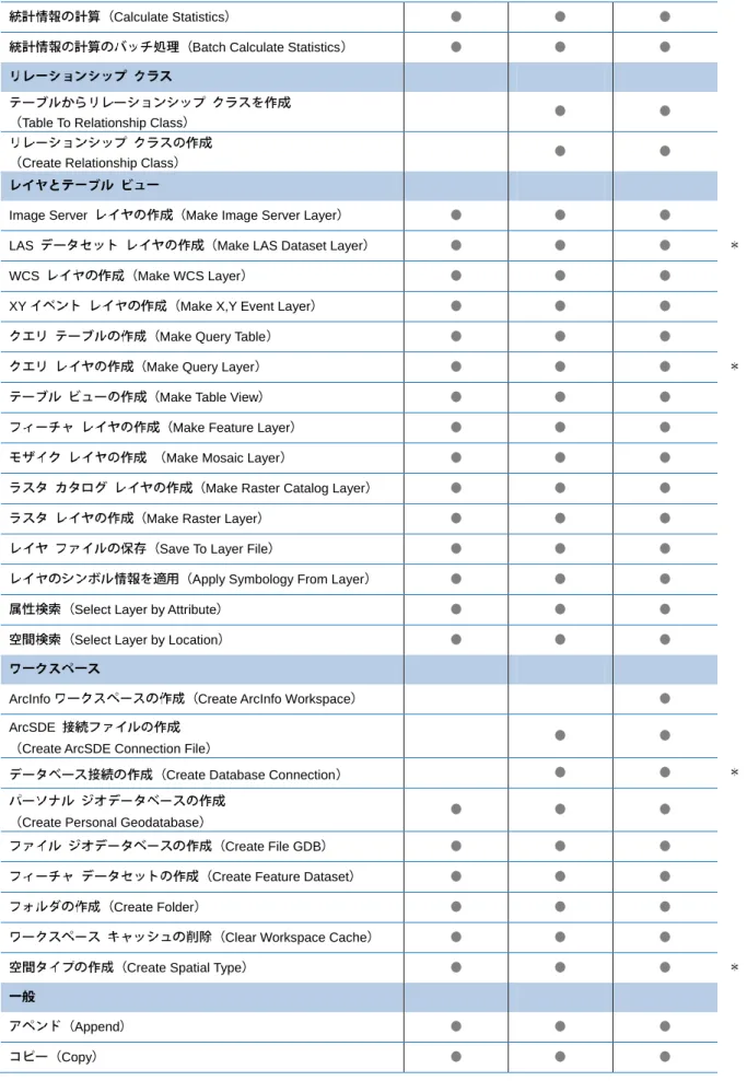
Calculate Statistics
Batch Calculate Statistics
Table To Relationship Class
Create Relationship Class
Image Server Make Image Server Layer
LAS Make LAS Dataset Layer
WCS Make WCS Layer
XY Make X,Y Event Layer
Make Query Table
Make Query Layer Make Table View
Make Feature Layer
Make Mosaic Layer
Make Raster Catalog Layer Make Raster Layer
Save To Layer File
Apply Symbology From Layer
Select Layer by Attribute Select Layer by Location
ArcInfo Create ArcInfo Workspace
ArcSDE
Create ArcSDE Connection File
Create Database Connection
Create Personal Geodatabase
Create File GDB
Create Feature Dataset
Create Folder
Clear Workspace Cache Create Spatial Type
Append
Select Data
Create Database View
Merge Branch Merge Sort Calculate Value Delete Delete Identical Find Identical Rename New!
Geotagged Photos To Points
Match Photos To Rows By Time
Global ID Add Global IDs
XML
Import XML Workspace Document
XML
Export XML Workspace Document
Create Replica From Server
Export Data Change Message
Import Message
Import Replica Schema
Export Replica Schema
Compare Replica Schema
Create Replica Footprints
Create Replica Synchronize Changes
Export Acknowledgement Message
Re-Export Unacknowledged Messages
Convert Coordinate Notation
Define Projection
Create Spatial Reference – Project Batch Project – Shift Rescale Mirror Register Raster Project Raster
Warp From File
Flip
Rotate
Warp
176 254 294
Basic
Standard
Advanced
Make Route Event Layer
Overlay Route Events
Dissolve Route Events
Transform Route Events
Locate Features Along Routes
Calibrate Routes
Create Routes
7 7 7
Basic
Standard
Advanced
NetCDF Make NetCDF Table View
NetCDF
Make NetCDF Feature Layer
NetCDF Table To NetCDF
Select by Dimension
NetCDF Feature To NetCDF
NetCDF Raster To NetCDF
7 7 7
Basic
Standard
Advanced
Manage Globe Server Cache Tiles
Delete Globe Server Cache
Manage Map Server Cache Status
Generate Map Server Cache Tiling Scheme
Import Map Server Cache
Export Map Server Cache
Manage Map Server Cache Tiles
Create Map Server Cache Delete Map Server Cache
Convert Map Server Cache Storage Format
Manage Map Server Cache Scales
Zip
Send Email With Zip File Attachment Extract Data
Extract Data and Email Task
Extract Data Task
New!
Stage Service
Upload Service Definition Sign Out From Portal
Sign In To Portal
New!
Web Export Web Map
1220 20 20
Basic
Standard
Advanced
/
Cluster and Outlier Analysis Anselin Local Morans I Grouping Analysis
Hot Spot Analysis Getis-Ord Gi*
Ripley K Multi-DistanceSpatial Cluster Analysis
Incremental Spatial Autocorrelation
Average Nearest Neighbor
SpatialAutocorrelation Morans I /
High/Low Clustering Getis-Ord General G
Collect Events ASCII
Export Feature Attribute To ASCII Convert Spatial Matrix To Table
Calculate Distance Band From Neighbor Count Calculate Areas
Z Z Score Rendering
Z /
Cluster/Outlier Analysis with Rendering Z
Hot Spot Analysis with Rendering
Count Rendering
Collect Events with Rendering
Central Feature
Directional Distribution Standard Deviational Ellipse Mean Center
Median Center Standard Distance
Generate Network Spatial Weights
Exploratory Regression
Geographically weighted regression
Ordinary least Squares Regression
Generate Spatial Weight Matrix
29 29 29
Basic
Standard
Advanced
Synchronize Mobile Cache
Create Mobile Map
2 2 2
Basic
Standard
Advanced
– Add Item Drop Item – Drop Index Index Item –
Line Coverage To Region
Line Coverage To Route
Polygon Coverage To Region
Region To Polygon Coverage –
Aggregate Polygons Simplify Building
Collapse Dual Lines To Ceterlines
Dissolve
Eliminate Find Conflicts
Simplify Line or Polygon –
XY Add X,Y Coordinates
Renumber Nodes ID Update IDs – Build Clean Create Label VPF VPF Tile Topology – Create Coverage – Define Projection Project Transform – Append –
Info Joint Info Tables
– Tolerance –
DLG Export To DLG .e00 Export To Interchange File
S57 Export To S57
SDTS Export To SDTS VPF Export To VPF
–
Advanced TIGER
Advanced TIGER Conversion Basic TIGER
Basic TIGER Conversion
Generate
DLG Import From DLG
.e00 Import From Interchange File
S57 Import From S57 SDTS Import From SDTS VPF Import From VPF – Erase Identity Intersect Union Update – Clip Select Split – Buffer Near Point Distance Point Node Thiessen 0 0 56
Basic
Standard
Advanced
Create Composite Address Locator Reverse Geocode
Package Locator Consolidate Locator
Rematch Addresses
Standardize Addresses
Create Address Locator
Rebuild Address Locator
9 9 9
Basic
Standard
Advamced
Snap Erase Point Trim Line Extend Line Flip Line Densify Generalize 0 7 7
Basic
Standard
Advanced
Load a Topology to a Parcel Fabric
Append Parcel Fabric
Copy Parcel Fabric
Make Parcel Fabric Table View
Make Parcel Fabric Layer
2 5 5
Basic
Standard
Advanced
DM
DM DM to Geodatabase
G-XML G-XML to Geodatabase
G-XML Export to G-XML
SIMA
SIMA SIMA to Geodatabase
SIMA Geodatabase to SIMA SXF Ver.3.0 SXF SXF to Geodatabase SXF Export to SXF 2000 2000 Geodatabase to chiseki2000 2000 chiseki2000 to Geodatabase Import FGD Export to FGD 11 11 11
Basic
Standard
Advanced
10 10 21 9 24 46 46 47 48 176 254 294 7 7 7 7 7 7 20 20 20 29 29 29 2 2 2 0 0 56 9 9 9 0 7 7 3 5 5 11 11 11 329 432 562