舩杉 力修
(島根大学法文学部准教授)Rikinobu Funasugi
Associate Professor,
Faculty of Law and Literature, Shimane University
The Understanding of
the United States Government Regarding the Geography of Takeshima Immediately
After the San Francisco Peace Treaty Came into Effect:
Drawing on US Government-Issued Aeronautical Charts Published in 1953 and 1954
The Understanding of
the United States Government Regarding the Geography of Takeshima Immediately
After the San Francisco Peace Treaty Came into Effect:
Drawing on US Government-Issued Aeronautical Charts Published in 1953 and 1954
平和条約発効直後の
米国政府の竹島に対する 地理的認識
− 1953年、1954年米国政府作製、発行の航空図を事例として −
平和条約発効直後の
米国政府の竹島に対する 地理的認識
− 1953年、1954年米国政府作製、発行の航空図を事例として −
平和条約発効直後の米国政府の竹島に対する地理的認識
- 1953 年、1954 年米国政府作製、発行の航空図を事例として-
舩杉力修(島根大学法文学部准教授)
1. はじめに (1)本稿の目的
(2)サンフランシスコ平和条約における竹島の扱いをめぐる日韓両国政府の見解 2. 航空図の記載内容
(1)USAF JET NAVIGATION CHART,(JN-25),YELLOW SEA(1954 年)
(2)USAF JET NAVIGATION CHART,(JN-26),SEA OF JAPAN(1954 年)
(3)USAF PILOTAGE CHART,(379D)G,TO DONG,JAPAN-KOREA(1953 年)
3. 該当の航空図の前の版との比較 4. おわりに
The Understanding of the United States Government Regarding the Geography of Takeshima Immediately After
the San Francisco Peace Treaty Came into Effect:
Drawing on US Government-Issued Aeronautical Charts Published in 1953 and 1954
Rikinobu Funasugi, Associate Professor, Faculty of Law and Literature, Shimane University
1. Introduction
(1) Purpose of this paper
(2) Views of the governments of Japan and the Republic of Korea on the treatment of Takeshima in the San Francisco Peace Treaty
2. Details of textual and other information provided on aeronautical charts (1) USAF JET NAVIGATION CHART, (JN-25), YELLOW SEA(1954) (2) USAF JET NAVIGATION CHART, (JN-26), SEA OF JAPAN(1954) (3) USAF PILOTAGE CHART, (379D) G, TO DONG, JAPAN-KOREA(1953) 3. Comparison with previous editions of relevant aeronautical charts
4. Conclusion
1. はじめに
(1)本稿の目的
本稿は、サンフランシスコ平和条約発効 直後の米国政府の竹島に対する地理的認識 について、平和条約発効直後に発行された 米国政府作製の航空図を用いて、国際法を 踏まえた上で、歴史地理学、地図史の立場 から考察するものである1。
戦後のわが国の領土は、1951 年 9 月調 印、1952 年 4 月発効のサンフランシスコ 平和条約により規定された。一般的に平和 条約では付属地図が作製されるが、サンフ ランシスコ平和条約では、付属地図が作製 されなかった。サンフランシスコ平和条約 では、わが国が放棄すべき地域が列挙され た。しかしながら、後に述べるように、サ ンフランシスコ平和条約における竹島の扱 いについては、日韓双方で解釈に違いがみ られる。
国際法上、領土問題では第三国の公的地 図は原則として領有権の根拠にはならない が2、米国は、サンフランシスコ平和条約の 起草国であることから、米国政府作製の公 的地図は、第三国の公的地図であっても、
サンフランシスコ平和条約の内容を補強す る価値があると考えられる。したがって、
サンフランシスコ平和条約発効直後の米国 政府の地理的認識を分析することは、竹島 問題の研究にとっては重要な課題の一つで あるといえる。しかしながら、これまでの 竹島の領有権をめぐる研究において、サン
1 この論文は筆者の個人的見解であり、日本国 際問題研究所の見解を代表するものではない。
2 国際法が専門の荒木教夫白鷗大学教授による と、第三国の公的地図について、次のように言及 している。「第三者が印刷し、公刊した地図は、主 権に対する請求を認めさせる証拠を提供する統治 の事実に比べると価値がないという。しかし、例 えば、植民地から独立した諸国が、国境線をめぐ る紛争に関わったとき、旧本国の作成した地図に 依拠する場合、当該地図は第三者の公的地図とい うことになるが、そうした地図の価値をすべて否 定することはできない」とする。荒木教夫「領土・
国境紛争における地図の機能」、早稲田法学 74-3、
1999 年、13 頁。
1. Introduction
(1) Purpose of this paper
This paper examines the understanding of the United States government regarding the geography of Takeshima immediately after the San Francisco Peace Treaty came into effect. Taking international law into account, I use aeronautical charts compiled by the United States government and published immediately after the peace treaty came into force to consider the views of the United States from the perspectives of historical geography and cartographical history.1
After World War II, Japan’s postwar territory was defined by the San Francisco Peace Treaty, which was signed in September 1951 and came into effect in April 1952. A peace treaty is generally accompanied by a map or maps, but this was not the case with the San Francisco Peace Treaty. Instead, the treaty merely listed the territories over which Japan was to relinquish sovereignty under the terms of the peace. As we shall see, Japan and the Republic of Korea differ in their interpretations of how Takeshima was to be treated in the San Francisco Peace Treaty.
In territorial disputes, official maps compiled by a third country generally do not form a basis for territorial claims under international law.2 Since the United States was one of the main drafters of the San Francisco Peace Treaty, official maps drawn up by the US government are valuable sources of information that can help to supplement and clarify the content of the San Francisco Peace Treaty. These official maps are important resources for research on the Takeshima issue when analyzing the geographical views of the US government soon after the peace treaty came into effect. In spite of their importance, these official US maps, drawn up shortly after the
1 This paper represents the personal views of the author and does not necessarily represent the views of the Japan Institute of International Affairs.
2 Norio Araki, a professor in international law at Hakuoh University, has written about official maps produced by a third-party country as follows: “Although maps printed and published by a third country do not have as much value compared to the fact of governance as evidence for claims to sovereignty, nevertheless, in a case for example where newly independent countries are involved in a dispute over international boundaries, maps produced by the former colonial power are regarded as official maps produced by a third nation, but the value of such maps cannot be discounted entirely.” Norio Araki, “Ryodo/kokkyo funso ni okeru chizu no kino” (The function of maps in disputes over territory and boundaries), in Waseda Hogaku, 74-3, 1999, p.13.
フランシスコ平和条約発効直後の米国政府 作製の公的地図についてはほとんど検討さ れていない。
ただし、韓国側では、フランス・リヨン 第三大学のイ・ジンミョン(李鎮明)名 誉教授が、平和条約調印前の「1951 年 3 月 22 日、米国太平洋空軍司令官により制 定された KADIZ(韓国の防空識別圏)と JADIZ(日本の防空識別圏)の地図」と する航空図の写真を掲載し、解説には
「“Liancourt Rocks(Take Island)”[Dokdo]
は KADIZ(韓国の防空識別圏)に含まれて いる。この措置は今日まで有効のままであ る」と記している3。ただし、イ・ジンミョ ン教授は航空図のうち日韓の ADIZ の説明 を記しているだけで、この航空図のタイト ル、発行者、発行年月といった地図の基本 的情報を記していない。
航空図の記載内容からすると、この航 空 図 は、The Defense Mapping Agency Aerospace Center(( 米 国 国 防 総 省 ) 国 防 地 図 局 航 空 宇 宙 セ ン タ ー)、1987 年 9 月 発 行 の 500 万 分 1 航 空 図ʻGLOBAL NAVIGATION AND PLANNING CHART,
GNC-5,Central Asiaʼ,9-87,EDITION7(世 界的な航行及び計画用航空図、GNC-5、中 央アジア、1987 年 9 月、第 7 版)とみら れる。後年の航空図を使用し、その出典を きちんと明示せず、あたかも 1951 年の航 空図であると読み手に誤解を与えることな ど、研究者としてあるまじき行為である。
仮にこの航空図が 1951 年 3 月頃の航空 図であったとしても、GHQ は日本政府に 対して領土の決定は講和会議でなされると 回答していることから、サンフランシスコ 平和条約調印前の航空図を取り上げても、
平和条約の内容を反映しているとはいえな い。さらに後で述べるように、ADIZ(防 空識別圏)は領土・領空の限界・範囲を決 めるものではない。
米国の公的地図のうち、米国政府作製・
3 Li, Jin-Mieung,Dokdo:A Korean island rediscovered, Northeast Asian History Foundation, 2010, pp.237–238, p.329.
peace treaty, have been mostly overlooked in research to date on the question of territorial sovereignty over Takeshima.
On the Korean side, Li Jin-mieung, professor emeritus at the Université Jean Moulin Lyon 3 in France, included in a study on Dokdo (the Korean name for Takeshima) a photograph of an aeronautical chart dated March 22, 1951, which he describes as a “Map of KADIZ (Korea Air Defense Identification Zone) and JADIZ (Japan Air Defense Identification Zone), established by the Commander of the US Air Force of the Pacific (sic).” The explanatory note to the illustration claims that “ ‘Liancourt Rocks (Take Island)’ [Dokdo] is included in the KADIZ.
This measure remains valid until nowadays (sic).”3 However, Professor Li’s study merely quotes the note printed on the chart regarding the Japanese and Korean air defense identification zones. He fails to provide basic information on his source, including the title of the aeronautical chart, its publisher, or the date of publication.
From the content, it seems likely that the map in question is “Global Navigation and Planning Chart, GNC-5, Central Asia, 9-87, Edition 7,” a 1:5,000,000 map published by the Defense Mapping Agency Aerospace Center (US Department of Defense) in September 1987. By using charts published much later than the period in question, and failing to provide publication information, Professor Li misleads his readers, encouraging them to believe that he is discussing a map published in 1951. Professor Li’s actions violate academic integrity.
But in fact, even if this aeronautical chart did date from around March 1951, this would not affect my argument because the Supreme Commander for the Allied Powers (SCAP) responded to a query from the Japanese government about territorial issues by saying that these should be settled by the San Francisco peace conference. Citing aeronautical charts drawn up before the signing of the peace treaty is therefore without significance in clarifying the content of the treaty. And as I will explain later, an air defense identification zone does not define the limits or extent of territorial air or land space.
Aeronautical charts produced by US government agencies are important sources of information that demonstrate Washington’s understanding of Takeshima’s geography. There are three well-known types of aeronautical charts: those published by the International Civil Aviation Organization
3 Li Jin-mieung, Dokdo: A Korean Island Rediscovered, Northeast Asian History Foundation, 2010, pp.237–238, p.329.
発行の航空図は、米国政府の竹島に対する 地理的認識を示す上で重要な資料の一つ である。航空図は、国連の一機関である ICAO(国際民間航空機関)の航空図、民 間発行のジェプセン社の航空図、そして米 国政府の航空図が有名である4。航空図のな かでも、米国政府作製の航空図は、航空図 のガリバー的存在で、世界各地を 200 万 分 1 航空図、100 万分 1 航空図、50 万分 1 航空図などとして、ほぼくまなく覆って いる。質量ともに世界一を誇り、民用・軍 用に使用されていた。世界をこの縮尺でほ ぼすべての地域をカバーする最も精度の高 い地図であることから、航空でのナビゲー ション利用にとどまらず、「世界の地形図」
として、戦略上、探検用、報道取材用など 幅広く利用されている5とする。
筆 者 は、2012 年 6 月、 米 国 国 防 総 省 が 1980 年作製、1981 年発行した 200 万 分 1 航 空 図ʻJET NAVIGATION CHART,
JNC-26,EDITION 3ʼを、東京都内の古物 商から購入した。その結果、日本海で経緯 度が竹島と一致するものの、島名が記され ていない島と、ʻULLŬNG DOʼ(鬱陵島)との 間に、国境線が引かれ、国境線の南東には ʻJAPANʼ、北西にはʻKOREAʼと記され ており、この航空図では、鬱陵島は韓国領、
竹島は日本領としていることを確認した6。 そ の 後、2013 年 2 月、 米 国 国 防 総 省 が 1996 年作製、1997 年発行した 200 万 分 1 航 空 図ʻJET NAVIGATION CHART,
JNC-25,EDITION 5ʼのコピーの一部を、
米国国内の大学図書館から入手した。その 結果、日本海で経緯度が竹島と一致するも のの、島名が記されていない島があり、そ の島にはʻ(JAPAN)ʼと記されており、一
4 ちなみに、ICAO(国際民間航空機関)の航空図、
民間発行のジェプセン社の航空図では、竹島の領 有については記していない。またこれらの航空図 は国際法上、証拠価値はない。
5 太田 弘編著『航空図のはなし』、成山堂書店、
2007 年、44–45 頁。
6 2013 年 2 月 20 日読売新聞大阪本社版社会面
「80 年米の地図で「日本領」県入手」。この航空図 は現在島根県竹島資料室に寄託している。
(ICAO, a UN organization), those published by the private company Jeppesen, and those published by the United States government.4 The aeronautical charts published by the United States government cover almost the entire world, with maps scaled at 1:2,000,000, 1:1,000,000, and 1:500,000. As the world’s most comprehensive, precise, and widely circulated charts, they have been used for civilian and military purposes, and have been described as goliaths in the world of aeronautical charts. These topographical maps are used not only for flight navigation but also for many purposes including strategic planning, exploration, and media reporting.5
In June 2012, I purchased from an antiquarian bookseller in Tokyo a copy of the “Jet Navigation Chart, JN-26, Edition 3” (Sea of Japan), a 1:2,000,000-scale map drawn up by the US Department of Defense in 1980 and published in 1981.
On the chart, a national borderline is drawn between Ullŭng Do (Ulleungdo, or Utsuryo To in Japanese) and another island which has a latitude and longitude corresponding with the coordinates of Takeshima, although its name is not marked on the chart. The area to the southeast of this line is marked
“Japan,” and the area to its northwest is marked “Korea.” This confirms that on this chart, Ulleungdo is shown as Korean territory and Takeshima as Japanese territory.6
In February 2013, I obtained from a university library in the United States a photocopy of a 1:2,000,000 aeronautical chart:
“Jet Navigation Chart, JN-25, Edition 5” (Yellow Sea), drawn up by the US Department of Defense in 1996 and published in 1997. The map showed an island which had coordinates and a position that corresponded to those of Takeshima, though no name for the island was given. Above the island was the text
“Japan,” while the island of “Ullŭng Do” was marked “South Korea,” confirming that this chart too showed Ulleungdo as
4 Incidentally, neither the aeronautical charts produced by the ICAO nor those produced by the private company Jeppesen contain any information regarding sovereignty over Takeshima. They would have no value as evidence in international law.
5 Hiroshi Ota, Kokuzu no hanashi (About aeronautical charts), Seizando Shoten, 2007, pp.44–45.
6 Yomiuri Shimbun, Osaka edition, February 20, 2013: “80-nen Bei no chizu de ‘Nihonryo’ Ken nyushu” (Prefecture obtains US map from 1980 showing island to be Japanese territory). This map has since been donated to Shimane Prefecture’s Takeshima Reference Room.
方、ʻULLŬNG DOʼ(鬱陵島)にはʻ(SOUTH KOREA)ʼと記されていることから、この 航空図でも、鬱陵島は韓国領、竹島は日本 領としていることを確認した7。
これらの航空図は、サンフランシスコ平 和条約発効後、29 年、45 年経過した地図 ではあるものの、米国政府の竹島に対する 地理的認識を示す重要な資料であることが 分かった。したがって、サンフランシスコ 平和条約発効直後の米国政府作製の航空 図の記載を分析すれば、サンフランシスコ 平和条約調印、発効時の米国政府の竹島に 対する地理的認識が確認できる。そこで、
2019 年度、日本国際問題研究所から島根 大学に委託された受託研究において、米国 国立公文書館所蔵の米国政府作製の航空図 の調査を、東京都内の民間調査会社に委託 し実施した。
(2) サンフランシスコ平和条約における 竹島の扱いをめぐる日韓両国政府の 見解
サンフランシスコ平和条約における竹島 の扱いについては、元東海大学教授の塚本 孝氏の長年の研究によってすでに明らかに されている8。また日本政府の見解は、外務 省のホームページに次のように掲載されて いる9。
--- 1. 1951(昭和 26)年 9 月に署名され たサンフランシスコ平和条約は , 日 本による朝鮮の独立承認を規定する とともに , 日本が放棄すべき地域と して「済州島 , 巨文島及び鬱陵島を
7 2013 年 3 月 28 日読売新聞島根版「米 1997 年 竹島「JAPAN」 国防総省の航空図記載」。
8 例えば、塚本孝「サンフランシスコ平和条 約と竹島―米外交文書集より―」、レファレンス 33-6、1983 年。同「平和条約と竹島―再論―」、
レファレンス 44-3、1994 年など。
9 外務省ホームページ「竹島」、「竹島問題の概 要」、「サンフランシスコ平和条約における竹島 の 取 扱 い 」https://www.mofa.go.jp/mofaj/area/
takeshima/g_sfjoyaku.html(2021 年 4 月 18 日 最終閲覧)
Korean and Takeshima as Japanese territory.7
Even though these charts were produced 29 and 45 years respectively after the San Francisco Peace Treaty came into effect, they remain important sources of information that indicate the understanding of the United States government regarding the geography of Takeshima. By analyzing the text printed on aeronautical charts produced by the United States government directly after the peace treaty came into effect, it should be possible to confirm the US government’s understanding of Takeshima’s geography when the treaty was signed and came into effect. A private research company based in Tokyo was accordingly hired to conduct a study of US government-produced aeronautical charts in the collections of the US National Archives. This study was carried out in fiscal 2019 as part of a research project undertaken by Shimane University on behalf of the Japan Institute of International Affairs.
(2) Views of the governments of Japan and the Republic of Korea on the treatment of Takeshima in the San Francisco Peace Treaty
Research carried out over many years by Takashi Tsukamoto, a former professor at Tokai University, has already made clear the treatment of Takeshima in the San Francisco Peace Treaty.8 The views of the Japanese government are given as follows on the website of the Ministry of Foreign Affairs.9
--- 1. The San Francisco Peace Treaty, signed in September
1951, stipulated that Japan should recognize the independence of Korea, and that Japan should renounce all rights, titles and claims to “Korea, including the islands of Quelpart, Port Hamilton and Dagelet.”
7 Yomiuri Shimbun, Shimane edition, March 28, 2013: “Bei 1997-nen Takeshima ‘Japan’ Kokubososho no kokuzu kisai” (US Department of Defense marked Takeshima as “Japan” on 1997 aeronautical charts).
8 For example, Takashi Tsukamoto, “San Furanshisuko Joyaku to Takeshima: Bei-gaiko bunsho-shu yori” (The San Francisco Treaty and Takeshima: From collections of US diplomatic papers), The Reference 33-6, 1983. Also, “Heiwa joyaku to Takeshima: Sairon” (The Peace Treaty and Takeshima: Reconsidered), The Reference 44-3, 1994.
9 The Ministry of Foreign Affairs of Japan maintains information relating to Takeshima in English and several other languages: “Treatment of Takeshima in the San Francisco Peace Treaty” https://www.mofa.
go.jp/a_o/na/takeshima/page1we_000062.html (Accessed June 1, 2021).
含む朝鮮」と規定しました。
2. この部分に関する米英両国による 草案内容を承知した韓国は , 同年 7 月 , 梁(ヤン)駐米韓国大使からア チソン米国務長官宛の書簡を提出し ました。その内容は ,「我が政府は , 第 2 条 a 項の『放棄する』という語 を『(日本国が)朝鮮並びに済州島 , 巨文島 , 鬱陵島 , 独島及びパラン島 を含む日本による朝鮮の併合前に朝 鮮の一部であった島々に対するすべ ての権利 , 権原及び請求権を 1945 年 8 月 9 日に放棄したことを確認す る。』に置き換えることを要望する。」
というものでした。
3. この韓国側の意見書に対し , 米国は , 同年 8 月 , ラスク極東担当国務次官 補から梁大使への書簡をもって次の とおり回答し , 韓国側の主張を明確 に否定しました。
「…合衆国政府は ,1945 年 8 月 9 日 の日本によるポツダム宣言受諾が同 宣言で取り扱われた地域に対する日 本の正式ないし最終的な主権放棄を 構成するという理論を(サンフラン シスコ平和)条約がとるべきだとは 思わない。ドク島 , または竹島ない しリアンクール岩として知られる島 に関しては , この通常無人である岩 島は , 我々の情報によれば朝鮮の一 部として取り扱われたことが決して なく ,1905 年頃から日本の島根県隠 岐島支庁の管轄下にある。この島は , かつて朝鮮によって領有権の主張が なされたとは見られない。…」
これらのやり取りを踏まえれば , サ ンフランシスコ平和条約において竹 島は我が国の領土であるということ が肯定されていることは明らかで す。
4. なお ,1954 年に韓国を訪問したヴァ ン・フリート大使の帰国報告にも , 竹島は日本の領土であり , サンフラ ンシスコ平和条約で放棄した島々に は含まれていないというのが米国の 結論であると記されています。
2. Upon learning of this section drafted by the United States and the United Kingdom, in July 1951 the ROK submitted a letter to Dean G. Acheson, the Secretary of State of the United States, from Yang Yu Chan, ROK Ambassador to the United States. This letter contained the following statement:
My Government requests that the word “renounces” in Paragraph A, Article Number 2, should be replaced by
“confirms that it renounced on August 9, 1945, all rights, titles and claims to Korea and the islands which were part of Korea prior to its annexation by Japan, including the islands [of] Quelpart, Port Hamilton, Dagelet, Dokdo and Parangdo.”
3. In response to this request from the ROK, in August of the same year the United States submitted a letter (an excerpt of which is shown below) from Dean Rusk, United States Assistant Secretary of State for Far Eastern Affairs, to Ambassador Yang, and in it clearly denied the claims of the ROK:
...the United States Government does not feel that the Treaty [the San Francisco Peace Treaty] should adopt the theory that Japan’s acceptance of the Potsdam Declaration on August 9, 1945, constituted a formal or final renunciation of sovereignty by Japan over the areas dealt with in the Declaration. As regards to the island of Dokdo, otherwise known as Takeshima or Liancourt Rocks, this normally uninhabited rock formation was according to our information never treated as part of Korea and, since about 1905, has been under the jurisdiction of the Oki Islands Branch Office of Shimane Prefecture of Japan. The island does not appear ever before to have been claimed by Korea.
Based on this correspondence, in the San Francisco Peace Treaty, it is obvious that Takeshima was affirmed as a territory of Japan.
4. The report by Ambassador Van Fleet after visiting the ROK in 1954 and returning to the United States also states that the United States concluded that Takeshima was a territory of Japan and the island was not included among the islands that Japan released from its sovereignty under the San Francisco Peace Treaty.
--- すなわち、サンフランシスコ平和条約で は、朝鮮放棄条項10において、放棄する領 土に竹島が列挙されていないこと、また、
韓国政府のサンフランシスコ平和条約草案 への要望に対する米国政府の回答にあた る、1951 年 8 月 10 日付、米国国務次官 補のラスクからの書簡においても、日本が 放棄する領土に竹島を入れるようにとした 韓国政府の要求が米国政府により却下され ていることなどから、サンフランシスコ平 和条約において、竹島が日本領として保持 されたことは国際法上、すでに自明の理で あるといえる。
さらに、日本政府の主張を補強するも のとして、2008 年 7 月 30 日の米国ホワ イトハウス定例記者会見において「米国 政府の立場は 1952 年以来変わっていな い。米国政府は基本的に竹島問題に関与し ない」11と表明していることが挙げられる。
すなわち、米国政府は、首尾一貫して、自 国の利益に関係しない第三国の領土紛争に は関与しない立場をとっているものの、記 者発表の前半部分では、米国政府が 1951 年 8 月の「ラスク書簡」、1951 年 9 月調印、
1952 年 4 月発効のサンフランシスコ平和 条約、1954 年 8 月の「ヴァン・フリート 特命報告書」の見解をいまだに変えていな いことを示しており、竹島問題についての 米国政府の立場を示す非常に重要な発言で あるといえる。
10 「日本国は、朝鮮の独立を承認して、済州島、
巨文島及び欝陵島を含む朝鮮に対するすべての権 利、権原及び利益を放棄する」
11 米国ホワイトハウスホームページ、2008 年 7 月 30 日、 報 道 官 ブ リ ー フ ィ ン グ、ʻPress Briefing by Senior Director for Asian Affairs at the National Security Council, Dennis Wilder, on President's Trip to Asiaʼhttps://
georgewbush-whitehouse.archives.gov/news/
releases/2008/07/20080730-13.html(2021 年 4 月 18 日最終閲覧)
--- To summarize: Takeshima was not listed among the territories to be relinquished by Japan in the article concerning renunciation of claims over Korea10 in the San Francisco Peace Treaty. The US government officially rejected the Korean government’s request to include Takeshima among the territories to be given up by Japan, in a letter dated August 10, 1951, written by Dean Rusk, United States Assistant Secretary of State for Far Eastern Affairs. In light of these facts, we can conclude that Takeshima was clearly retained as part of Japanese territory in the San Francisco Peace Treaty.
Further reinforcement for the position of the Japanese government can be found in the statement made at a regular press briefing at the White House in Washington, DC on July 30, 2008. The statement read: “Our policy on this territorial dispute has been firm and consistent since 1952, and that is, we do not take a position on this territorial dispute.”11 This extremely important statement shows that although the United States government has consistently maintained a stance of not getting involved in territorial disputes between third-party countries that do not affect its own interests, the US government has not changed its view on the issue since the Rusk letter of August 1951, the San Francisco Peace Treaty (signed in September 1951, effective from April 1952), and the Van Fleet report of August 1954.
10 “Japan recognizing the independence of Korea, renounces all right, title and claim to Korea, including the islands of Quelpart, Port Hamilton and Dagelet.”
11 Available on the White House website: “Press Briefing by Senior Director for Asian Affairs at the National Security Council, Dennis Wilder, on President’s Trip to Asia,” July 30, 2008. https://georgewbush- whitehouse.archives.gov/news/releases/2008/07/20080730-13.html (Accessed April 18, 2021).
しかしながら、韓国政府は、わが国とは 正反対の解釈を行っている。まず、日韓 両国政府間の文書の往復12では、① 1953 年 9 月 9 日付の「独島(竹島)に関する 1953 年 7 月 13 日付日本政府見解に対す る韓国政府の論駁」では、「1946 年 1 月 29 日付け連合軍総司令官指令第 677 号は、
独島をはっきりと日本の領有権外に置いて おり、対日講和条約には、日本領土問題に 関する限り、同司令の条項と矛盾する条項 がない。講和条約は、この問題に関する連 合軍総司令官の意向を、なんら実質的変化 なしに確認した。」とし、② 1954 年 9 月 25 日付の「1954 年 2 月 10 日付日本外務 省口上書第 15 号亜二に関する日本政府の 見解を反駁する韓国政府の見解」では、「対 日講和条約には独島に対する韓国の正当な 領有権主張に矛盾する条文はない。そして 同条約第 1 章第 2 条 A(原文ママ、筆者注:
第 2 章)により、独島が鬱陵島の属島とし て鬱陵島本島とともに韓国領土として承認 されたと解釈される。」とし、③ 1959 年 1 月 7 日付の「1956 年 9 月 20 日付け独 島に関する日本政府の見解を反駁する大韓 民国政府の見解」では、「独島は、SCAPIN 第 677 号により、非隣接島嶼として隣接 諸小島とは明白に区別され、1947 年 6 月 19 日、日本に対する降伏後の基本政策に よって、日本の領土は隣接島嶼にのみ局限 されたことから、日本からの独島の分離は これにより確定された。したがって、対日 平和条約に独島を日本に領土を編入すると いう積極的な規定がないので、日本から分 離が確定した地位には、いかなる変動もあ りえない。このように独島の処理はポツダ ム宣言から日本の降伏後の基本政策に至る 一連の文書によって統一的に理解されなけ ればならず、そのような用意なく SCAPIN 第 677 号の第 6 項だけで全体を歪曲しよ うとする日本側の態度は、不当である。特 に留意しなければならない点は、韓国は対
12 以下、韓国政府の文書は、塚本孝「竹島領有 権をめぐる日韓両国政府の見解」、レファレンス 52-6、2002 年による。
Despite this, the government of the Republic of Korea’s interpretation is diametrically opposite to the Japanese view.
The extent of these differences is made clear by a series of diplomatic notes verbales between the Korean and Japanese governments, as follows.12
1 ) In a “rebuttal to the views of the Japanese government of July 13, 1953, on Dokdo [Takeshima]” dated September 9, 1953, the Korean government wrote:
SCAPIN [Supreme Commander for the Allied Powers Instruction Note] 677, dated January 29, 1946, clearly placed Dokdo outside Japanese territory, and the section of the peace treaty dealing with Japanese territory contains nothing that contradicts this memorandum. The treaty therefore confirmed the intentions of the Supreme Commander for the Allied Powers on this issue without any changes.
2 ) In a note outlining the “Views of the Korean government”
dated September 25, 1954, regarding note verbale No. 15 A-2 sent by the Japanese Ministry of Foreign Affairs on February 10, 1954, the Korean side wrote:
The peace treaty with Japan contains nothing that contradicts Korea’s legitimate claim to territorial sovereignty over Dokdo. Furthermore, our interpretation is that Chapter 1(sic), Article 2A (The correct reference should be to Chapter 2, Article 2A of the treaty.) of the treaty recognizes Dokdo as Korean territory along with Ulleungdo [Dagelet], as a dependency of Ulleungdo.
3 ) In a note dated January 7, 1959, outlining the “Views of the government of the Republic of Korea, in rebuttal of the views of the government of Japan regarding Dokdo of September 20, 1956,” Korea wrote:
12 This and all following documents released by the government of the Republic of Korea are taken from Takashi Tsukamoto, “Takeshima ryoyuken o meguru Nik-kan ryogoku seifu no kenkai” (Views of the Japanese and Korean Governments on Takeshima), The Reference, 52- 6, 2002.
日平和条約に先だって既に 1948 年 8 月に 独立を達成して以来、独島の管理統治を回 復しており、そのような状態の下で対日平 和条約の該当時国から正式承諾を受けてい たという事実である。独島は、連合軍総司 令官が管理する周辺小島でもなく、また、
韓国独立後合衆国の立法及び司法権の行使 に留保された地域でもなかった。さらに、
独島に関する日本のいわゆる「残存主権」
が設定されたこともなかった。」としてい る。以上、要するに、韓国側は、1946 年 の連合軍総司令官指令 SCAPIN 第 677 号 によって、竹島が韓国領となったことは確 定しており、サンフランシスコ平和条約で 竹島が日本領であるとの規定がない以上、
SCAPIN677 号での決定は変動がないとし ている。本稿は国際法の論文ではなく、ま た、国際法上の SCAPIN677 号、平和条約 に関する韓国側の主張に対しては、すでに 日本政府、そして日本側の研究者によって 反論がなされているので、ここでは詳細に 触れないが、SCAPIN677 号はわが国が占 領管理下において限定されて規定されたも のであり、その第 6 項にあるように、日本 領土の最終決定とは無関係であり、最終決 定は平和条約でなされたことは言うまでも ない。したがって、韓国政府の主張は国際 法上成り立ち得ない。また、韓国側の一連 の文書では、米国政府が韓国政府に通達し たラスク書簡などには一切言及がないこと が注目される。
SCAPIN 677 explicitly treats Dokdo separately from the “adjacent smaller islands,” and since Japanese territory was limited to the [main islands and] adjacent smaller islands in the basic policy after Japan’s surrender, published on June 19, 1947, this confirms the separation of Dokdo from Japanese territory. Since the Treaty of Peace with Japan contains no ruling positively including Dokdo within Japanese territory, no change is possible from the previously confirmed position, namely that the island would be separated from Japan. It is necessary to have a unified understanding of the treatment Dokdo based on the various documents from the Potsdam Declaration to the basic policy after Japan’s surrender.
Japan’s position, which attempts to distort the whole by taking Article 6 of SCAPIN 677 out of context, is inappropriate. In particular, we should remember that Korea achieved independence in August 1948—
in advance of the Treaty of Peace with Japan—and accordingly recovered control and administration over Dokdo, and received formal acknowledgement of this from the countries involved in formulating the Peace Treaty at the time. Dokdo was not one of the peripheral small islands under the control of SCAP, nor was it a region over which the United States retained legislative and judicial control after Korean independence. Furthermore, Japan never established what it claims as “residual sovereignty” over Dokdo.
The Korean view is essentially that Takeshima became Korean territory as a result of SCAPIN 677, published in 1946, and that since the San Francisco Peace Treaty does not contain any clause explicitly declaring Takeshima to be Japanese territory, there has been no change to the decision laid out in SCAPIN 677. This is not an essay on international law, and counterarguments in response to the Korean appeals to international law regarding SCAPIN 677 and the Peace Treaty have already been made by the Japanese government and Japanese scholars, so I will not go into a detailed discussion here. Suffice it to say that SCAPIN 677 was a ruling issued under the special and limited circumstances of Japan’s temporary occupation. This is made clear in Article 6 of the ruling:
“Nothing in this directive shall be construed as an indication of Allied policy relating to the ultimate determination of the minor islands referred to in Article 8 of the Potsdam Declaration,” a final decision on which was to be made in the Peace Treaty. The
さらに、現在の韓国政府のサンフランシ スコ平和条約についての見解は、韓国・外 交部のホームページ「韓国の美しい島 独 島」で確認できる13。ホームページのうち、
「大韓民国の領土である根拠」の「サンフ ランシスコ平和条約の締結」において、「サ ンフランシスコ平和条約は、第 2 次世界大 戦終結のため、連合国と日本の間で締結さ れた条約です。この条約の第 2 条(a)で「日 本は韓国の独立を承認して、済州島、巨文 島及び鬱陵島を含む韓国に対するすべての 権利、権原及び請求権を放棄する」と規定 しています。この“済州島、巨文島及び鬱 陵島”は韓国の 3 千あまりの島嶼の例に過 ぎず、独島が直接明示されていないからと いって独島が韓国の領土に含まれていない と見ることはできません」と、している。
基本的に、1950 年代の韓国政府の見解を 踏襲していることが分かる。しかしながら、
サンフランシスコ平和条約調印前に、米国 政府が韓国政府に対して、サンフランシス コ平和条約において竹島は日本領であると 通知したラスク書簡への言及がないことか ら、この見解も成り立ち得ないのである。
このように、国際法上、ラスク書簡、サ ンフランシスコ平和条約、ヴァン・フリー ト特命報告書から、戦後竹島が日本領とし て保持されたことは明らかであるが、未だ に韓国政府、韓国及びわが国の一部研究者 は、1950 年代の韓国政府の見解を踏襲し ている。またラスク書簡は、サンフランシ スコ平和条約に関する米国政府から韓国政 府に対して通知された公式の外交文書であ るにもかかわらず、韓国の研究者からは、
無効であるとの主張がみられるのが現状で ある。そこで本稿では、国際法を踏まえな がらも、従来の国際法上の分析から観点を 変え、地図は二次的な証拠にすぎないもの の、条約起草国である米国政府作製の地図
13 韓国・外交部ホームページ「韓国の美しい 島 独島」、「大韓民国の領土である根拠」、「サンフ ランシスコ平和条約の締結」https://dokdo.mofa.
go.kr/jp/dokdo/reason.jsp(2021 年 4 月 18 日最 終閲覧)
Korean government’s claims are consequently unsustainable in international law. It is also worth noting that nowhere in the various notes and other documents issued by the Korean government is there any mention of the Rusk letter sent by the US government to the Korean government.
We can confirm the current views of the Korean government regarding the San Francisco Peace Treaty via the informational internet page “Dokdo, Beautiful Island of Korea,” hosted on the official website of the Korean Ministry for Foreign Affairs.13 The section “Why Dokdo is Korean Territory” contains the following account of the “Conclusion of the Treaty of Peace with Japan”: “The Treaty of Peace with Japan is a treaty which the Allied Powers concluded with Japan at the close of World War II. Article 2 (a) provides that “Japan, recognizing the independence of Korea, renounces all right, title and claim to Korea, including the islands of Quelpart, Port Hamilton and Dagelet.” The webpage goes on to say that Among Korea’s approximately 3,000 islands, these three islands have been referred to as examples, and therefore, the mere fact that Dokdo is not named in the said article, does not suggest that Dokdo is not included among those territories of Korea that have been separated from Japan.” It is clear that the Korean government today has essentially inherited the views of the Korean government of the 1950s more or less unchanged. However, there is still no mention of the Rusk letter, in which the US government informed Korea before the treaty was signed that the San Francisco Peace Treaty treated Takeshima as Japanese territory. The current Korean view is therefore also untenable.
It is clear from the Rusk letter, the San Francisco Peace Treaty, and the report of the Van Fleet mission that according to international law, Takeshima was retained as Japanese territory after World War II. Despite this, the Korean government and some scholars in Korea and Japan continue to adhere to the views put out by the Korean government during the 1950s.
Some Korean scholars today maintain that the Rusk letter cannot be considered as valid evidence—even though it was official diplomatic correspondence sent from the US government to the government of Korea. In this paper, while continuing to consider international law, I want to move
13 See the section “Conclusion of the Treaty of Peace with Japan” under
“Why Dokdo is Korean Territory” part of “Dokdo, Beautiful Island of Korea,” available on the website of the Korean Ministry of Foreign Affairs: https://dokdo.mofa.go.kr/eng/dokdo/reason.jsp (Accessed June 3, 2021).
を取り上げ、サンフランシスコ平和条約発 効直後の竹島に対する米国政府の地理的認 識を分析することにより、サンフランシス コ平和条約における竹島の扱いについて検 討することとする。
away from traditional international-law-based perspectives.
Although maps are no more than secondary proof, I will look at official maps produced by the government of the United States, as a drafter of the treaty, and use them to consider the treatment of Takeshima in the San Francisco Peace Treaty by analyzing the US government’s understanding of Takeshima’s geography immediately after the Peace Treaty came into effect.
2. 航空図の記載内容
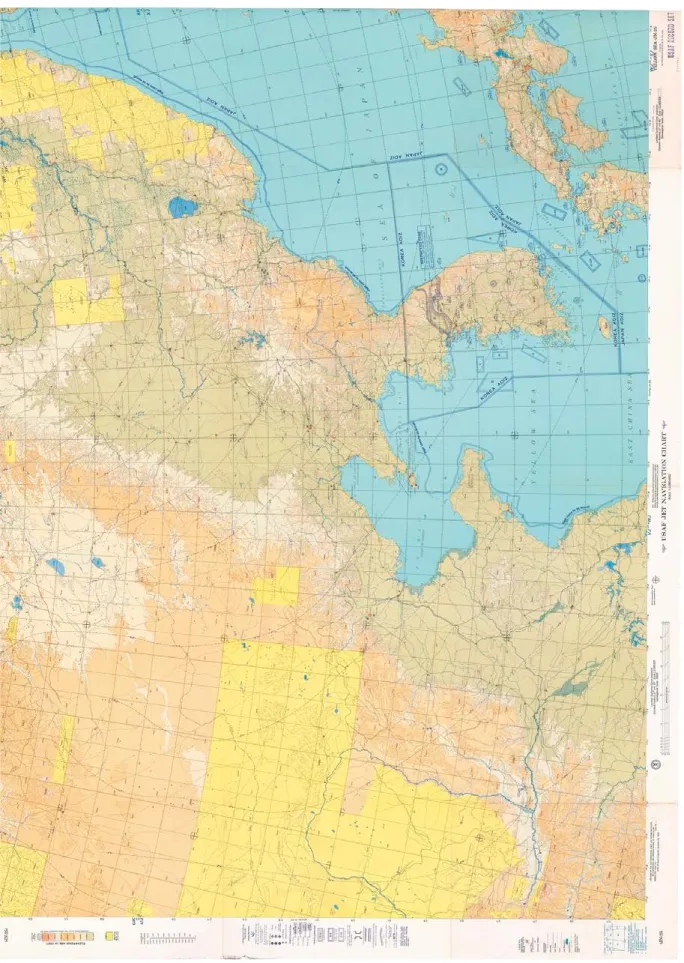
米国国立公文書館での調査の結果、サン フランシスコ平和条約発効直後の米国政府 作製の航空図は 3 点確認することができた。
いずれも米国空軍が作製、発行した航空図 で、サンフランシスコ平和条約発効の 1 年 後の 1953 年、2 年後の 1954 年発行である。
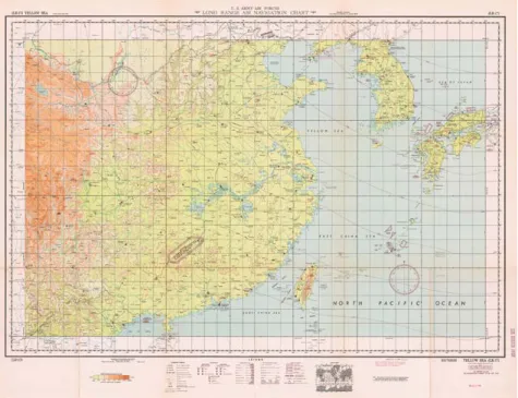
(1)USAF JET NAVIGATION CHART,
(JN-25),YELLOWSEA(1954 年)
この航空図のタイトルは、ʻUSAFJET NAVIGATIONCHART,(JN-25),YELLOW SEAʼ,9-54,1stEDITION(米国空軍・ジェッ ト機用航空図、(JN-25)、黄海、1954年9月、
第1版)で、発行者は USAFAERONAUTICAL CHARTANDINFORMATIONCENTER,AIR PHOTOGRAPHICANDCHARTINGSERVICE
(米国空軍航空図・情報センター(ACIC)、航 空写真撮影・海図作成サービス(APCS))で ある。すなわち、米国空軍が発行したもので ある。発行年月は、1953年8月刊行、1954年 9月印刷である。
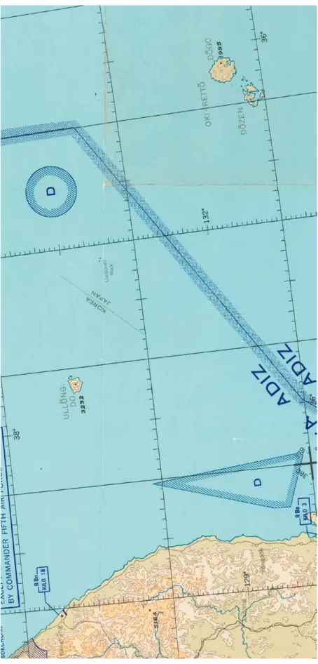
縮尺は、200 万分 1 で、日本列島西部、
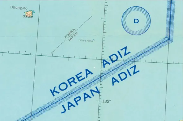
朝鮮半島、中国東部、ロシア極東地域、モ ンゴルが記されている【図 1】。日本海で は、朝鮮半島と隠岐諸島の間に、鬱陵島 と竹島が記されている【図 2】。鬱陵島は、
ʻULLŬNGDOʼと韓国名で記されている。
3232 はフィートで、約 985m、鬱陵島の 最高峰聖人峰の標高 984m を指している。
竹島は、ʻLiancourtRockʼと西洋名(フ ランス名)で記されている。島が 2 つ記さ れており、これは男島(西島)、女島(東島)
を指している。
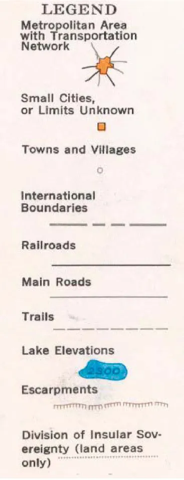
竹島の北東にある、ʻDʼと記した区域は、
ʻAERONAUTICALLEGENDʼ(航空の凡例)
によると、ʻDanger,RestrictedorWarning Areaʼ(危険、制限、または警告区域)で、
米軍の訓練区域であると考えられる。
竹島と隠岐諸島の間には、ʻKOREAADIZʼと ʻJAPANADIZʼが設定されている。ADIZ(Air
DefenseIdentificationZone)とは防空識別 圏を指し、凡例にもそのように記されている。
すなわち、竹島は、韓国側の防空識別圏に 入っている。韓国政府の一部関係者は竹島 2. Details of textual and other information provided on
aeronautical charts
Work to retrieve information at the National Archives of the United States has made it possible to confirm the content of three aeronautical charts produced by the US government immediately after the San Francisco Peace Treaty came into effect. All three charts were produced and issued by the US Air Force, and were published in 1953 and 1954, one to two years after the Peace Treaty came into effect.
(1) USAF Jet Navigation Chart, (JN-25), Yellow Sea (1954) The title of this map is “USAF Jet Navigation Chart, JN-25, Yellow Sea,” 9-54, 1st Edition. The publisher is listed as the USAF Aeronautical Chart and Information Center (ACIC), Air Photographic and Charting Service (APCS)—in other words, the map was published by the US Air Force. The publication date is given as August 1953 and the printing date is September 1954.
The map has a scale of 1:2,000,000, and shows the western part of the Japanese archipelago, the Korean Peninsula, eastern China, the Russian Far East, and Mongolia (Fig. 1). In the Sea of Japan, Ulleungdo and Takeshima are shown between the Korean Peninsula and the Oki Islands (Fig. 2). Ulleungdo is marked with its Korean name, spelled “ULLǓNG DO.”
The number 3232 indicates an altitude in feet (equivalent to approximately 985 meters), showing the elevation above sea level of Seonginbong, the highest mountain on Ulleungdo, at 984 meters. Takeshima is marked using its Western (originally French) name, as “Liancourt Rock.” Two islands are marked:
Ojima (or Nishijima, West Island) and Mejima (Higashijima, East Island).
According to the map’s legend, labeled “Aeronautical Legend,” the area to the northeast of Takeshima marked
“D” represents “Danger, Restricted or Warning Area,” and presumably marks a US armed forces training area. Between Takeshima and the Oki Islands are markings showing the
“KOREA ADIZ” and the “JAPAN ADIZ,” or “Air Defense Identification Zone,” as is explained on the map legend.
Takeshima is therefore included within the Korea’s ADIZ.
Some people connected with the Korean government have claimed that Takeshima is Korean territory based on this inclusion. However, ADIZs are not an established system in international law, and lack legal underpinning. Generally, an ADIZ is something established internally by each country for air defense. An ADIZ is not considered to define the limits or
が韓国の防空識別圏に入っていることをもっ て、竹島が韓国領であると主張している。しか しながら、防空識別圏は、国際法上、法的 根拠が定められておらず、確立した制度では ない。一般的に、各国が防空上の観点から 国内措置として設定しているものであり、領 空・領土の限界や範囲を定める性格のもので はない。したがって、竹島が韓国側の防空 識別圏に入っていることをもって、国際法上、
竹島が韓国領である根拠にはならない。
extent of a country’s airspace or land territory. Takeshima’s inclusion in the Korea’s ADIZ consequently cannot be used as evidence in international law for the claim that the island is part of Korean territory.
Fig.1 “USAF JET NAVIGATION CHART, (JN-25), YELLOW SEA,” 9-54, 1st EDITION
【Collection of the National Archives of the United States】
図 1 ʻUSAFJETNAVIGATIONCHART,(JN-25),YELLOWSEAʼ,9-54,1stEDITION
(米国空軍・ジェット機用航空図、(JN-25)、黄海、1954 年 9 月、第 1 版)
【米国国立公文書館所蔵】
Fig.2 “USAF JET NAVIGATION CHART, (JN-25), YELLOW SEA,” 9-54, 1st EDITION (Showing the vicinity of Ulleungdo, Takeshima, and Oki Islands)
【Collection of the National Archives of the United States】
図 2 ʻUSAFJETNAVIGATIONCHART,(JN-25),YELLOWSEAʼ,9-54,1stEDITION
(米国空軍・ジェット機用航空図、(JN-25)、黄海、1954 年 9 月、第 1 版)
(鬱陵島・竹島・隠岐付近)【米国国立公文書館所蔵】
鬱陵島と竹島との間には、点線があり、
北西側にはʻKOREAʼ、南東側にはʻJAPANʼ と記されている。ʻLEGENDʼ(凡例)によ れ ば、 こ の 点 線 は、ʻDivisionofInsular Sovereignty(landareasonly)ʼ(島嶼の主 権の境界線(陸域のみ))を指す【図 3】。す なわち、この点線は、島嶼の主権を示してお り、海域の境界線ではない。海域については、
当時領海が沿岸から 3 海里(約 5.6km)ま でで、その外側は公海であった。したがって、
この航空図では、鬱陵島は韓国領、竹島は 日本領であることを示しているのである。
(2)USAF JET NAVIGATION CHART,
(JN-26),SEAOFJAPAN(1954 年)
こ の 航 空 図 の タ イ ト ル は、ʻUSAFJET NAVIGATIONCHART,(JN-26),SEAOF JAPANʼ,12-54,1stEDITION( 米 国 空 軍・ジェット機用航空図、(JN-26)、日本 海、1954年12月、第1版)で、発行者は USAF AERONAUTICALCHARTANDINFORMATION CENTER, AIR PHOTOGRAPHIC AND CHARTINGSERVICE(米国空軍航空図・情報 センター(ACIC)、航空写真撮影・海図作成 サービス(APCS))である。すなわち、米 国空軍が発行したものである。発行年月は、
1953年7月刊行、1954年12月印刷である。
縮尺は、200 万分 1 で、日本海を中心に 日本列島、南樺太、朝鮮半島、中国東北部、
ロシア極東地域が記されている。日本海で は、朝鮮半島と隠岐諸島の間に、鬱陵島と 竹島が記されている【図 4、図 5】。鬱陵島 は、ʻUllung-doʼと韓国名で記されている。
3232 はフィートで、約 985m、鬱陵島の 最高峰聖人峰の標高 984m を指している。
竹島は、ʻTake-shimaʼと、(1)とは違い、日 本名で記されている。島が 2 つ記されており、
これは男島(西島)、女島(東島)を指している。
竹島の北東にある、ʻDʼと記した区域は、
(1)と同様、ʻDanger,RestrictedorWarning Areaʼ(危険、制限、または警告区域)で、
米軍の訓練区域であると考えられる。
竹 島 と 隠 岐 諸 島 の 間 に は、ʻKOREA ADIZʼとʻJAPANADIZʼが設定されている。
ADIZ(AirDefenseIdentificationZone)と は防空識別圏を指している。(1)と同様、
A dotted line is marked between Ulleungdo and Takeshima.
The area to the northwest of this line is marked “Korea,” and the area to the southeast is marked “Japan.” On the legend, this type of dotted line is explained as a “Division of Insular Sovereignty (land areas only)” (Fig. 3). In other words, the line marks sovereignty over islands but not sovereignty over maritime areas. At the time, territorial waters extended three nautical miles, or about 5.6 km from the coast, and everything outside that was international waters. Consequently, the chart shows that Ulleungdo is Korean territory and Takeshima is Japanese.
(2) USAF Jet Navigation Chart, (JN-26), Sea of Japan (1954) The title of this aeronautical chart is “USAF Jet Navigation Chart, (JN-26), Sea of Japan” 12-54, 1st Edition, and the publisher is given as “USAF Aeronautical Chart and Information Center, Air Photographic and Charting Service.” In other words, it was published by the US Air Force. The date of publication is July 1953 and the printing date is December 1954.
The scale is 1:2,000,000 and the map is centered on the Sea of Japan, showing the Japanese archipelago, South Sakhalin, the Korean Peninsula, Northeast China, and the Russian Far East. In the Sea of Japan, Ulleungdo and Takeshima are shown between the Korean Peninsula and the Oki Islands (Figs. 4 and 5). Ulleungdo is marked with its Korean name, spelled Ullung- do. The number 3232 indicates an altitude in feet (equivalent to approximately 985 meters), and shows the elevation above sea level of Seonginbong, the highest point on Ulleungdo, at 984 meters. Unlike on Map 1, Takeshima is marked with its Japanese name, rendered as “Take-shima.” Two islands are shown: Ojima (Nishijima) and Mejima (Higashijima). As on Map 1, the area to the northeast of Takeshima is marked “D” for
“Danger: Restricted or Warning Area,” presumably indicating a US Forces training area.
Marked between Takeshima and the Oki Islands are the
“KOREA ADIZ” and the “JAPAN ADIZ”, showing the Air Defense Identification Zones. As on Map 1, Takeshima is included within the Korea’s ADIZ. However, in international law this fact cannot be used as evidence to support the contention that Takeshima is part of Korean territory.
As on Map 1, there is a dotted line between Ulleungdo and Takeshima, marked “Korea” on the northwest side and “Japan”
on the southeast. This dotted line marks “Division of Insular Sovereignty (land areas only).” In other words, as with Map 1, this chart too shows Ulleungdo as Korean territory and Takeshima as Japanese.
竹島は、韓国側の防空識別圏に入っている。
竹島が韓国側の防空識別圏に入っているこ とをもって、国際法上、竹島が韓国領であ る根拠にはならない。
鬱陵島と竹島との間には、(1)と同様、
点線があり、北西側にはʻKOREAʼ、南東 側にはʻJAPANʼと記されている。この点 線は、ʻDivisionofInsularSovereignty(land areasonly)ʼ(島嶼の主権の境界線(陸域 のみ))を指す。すなわち、(1)と同様、
この航空図でも、鬱陵島は韓国領、竹島は 日本領であることを示している。
Fig.3 “USAF JET NAVIGATION CHART, (JN-25), YELLOW SEA,” 9-54, 1st EDITION (Legend)【Collection of the National Archives of the United States】
図 3 ʻUSAFJETNAVIGATIONCHART,(JN-25),YELLOWSEAʼ,9-54,1stEDITION
(米国空軍・ジェット機用航空図、(JN-25)、黄海、1954 年 9 月、第 1 版)
(LEGEND(凡例))【米国国立公文書館所蔵】
Fig.4 “USAF JET NAVIGATION CHART, (JN-26), SEA OF JAPAN,” 12-54, 1st EDITION (Coastal regions around the Sea of Japan)【Collection of the National Archives of the United States】
Fig.5 “USAF JET NAVIGATION CHART, (JN-26), SEA OF JAPAN,” 12-54, 1st EDITION (Vicinity of Ulleungdo and Takeshima)【Collection of the National Archives of the United States】
図 4 ʻUSAFJETNAVIGATIONCHART,(JN-26),SEAOFJAPANʼ,12-54,1stEDITION
(米国空軍・ジェット機用航空図、(JN-26)、日本海、1954 年 12 月、第 1 版)
(日本海沿岸付近)【米国国立公文書館所蔵】
図 5 ʻUSAFJETNAVIGATIONCHART,(JN-26),SEAOFJAPANʼ,12-54,1stEDITION
(米国空軍・ジェット機用航空図、(JN-26)、日本海、1954 年 12 月、第 1 版)
(鬱陵島・竹島付近)【米国国立公文書館所蔵】
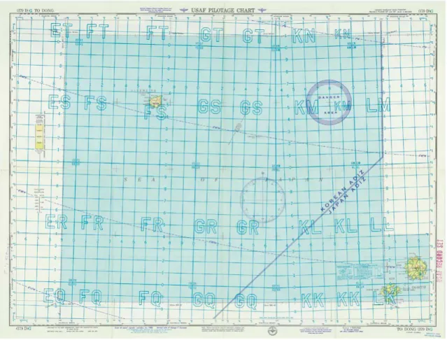
(3)USAFPILOTAGECHART,(379D)G,
TODONG,JAPAN-KOREA(1953 年)
こ の 航 空 図 の タ イ ト ル は、ʻUSAF PILOTAGECHART,(379D)G,TODONG,
JAPAN-KOREAʼ,12-53,1st EDITION Revised(米国空軍航空図、(379D)G、道洞、
日本 - 韓国、1953 年 12 月、第 1 版修正)で、
発 行 者 は USAFAERONAUTICALCHART ANDINFORMATIONCENTER(ACIC)( 米 国空軍航空図・情報センター(ACIC))である。
発行年月は、1943 年 11 月刊行、1953 年 6 月改 訂、1953 年 8 月印 刷、1953 年 12 月重刷である。縮尺は 50 万分 1 である。
この 50 万分 1 の航空図は、25 万分 1 航 空図とともに、100 万分 1 航空図 World AeronauticalChart(世界航空図)シリー ズを構成している。航空図の裏面には ʻINTERCHARTRELATIONSHIPʼ( 図 幅 接 合図)があり【図 6】、まず、100 万分 1 航 空図を 4 分割したのが 50 万分 1 航空図で、
A,B,C,D に分かれ、50 万分 1 航空図を さらに 4 分割したのが 25 万分 1 航空図で、
Ⅰ,Ⅱ,Ⅲ,Ⅳに分かれていることが図で示さ れている。図の下の解説には、「各航空図は、
100 万分 1 の WorldAeronauticalChart(世 界航空図)シリーズを構成するセクション で、図に示されているように、シリーズ内 で索引が付けられる」と記している。こ の 50 万分 1 航空図は、日本海南部を範囲 とした 100 万分 1 の WorldAeronautical Chart(世界航空図)379 の南西側にあた るので、番号が 379D となっている。
この航空図では、日本海南西部の鬱陵 島、竹島、隠岐諸島が記されている【図 7】。
地図のタイトルにある、ʻTODONGʼ(道洞)
は、鬱陵島の南東に位置し、鬱陵島に出入 りする港湾があるなど、鬱陵島の玄関口で、
中心地にあたる道洞(トドン)を指す。こ の航空図には、隠岐諸島も記されており、
また地図のタイトルに、ʻJAPAN-KOREAʼ とあり、地図の収録範囲が韓国と日本であ ることが示されていることから、地図のタ イトルが韓国・鬱陵島の「道洞」であっても、
地図の収録区域全体が韓国領ということは ない。また、この航空図では、竹島だけでなく、
隠岐列島も記載されていることから、竹島 (3) USAF Pilotage Chart, (379D) G, To Dong, Japan-Korea
(1953)
The title of this aeronautical chart is “USAF Pilotage Chart, (379D) G, To Dong, Japan-Korea,” 12-53, 1st Edition Revised.
The publisher is the USAF Aeronautical Chart and Information Center. The publication date is given as November 1943, with revisions as of June 1953. The date of printing is given as August 1953, with overprinting as of December 1953. The scale is 1:500,000.
Charts like this, on a 1:500,000 scale, together with 1:250,000 charts, make up the 1:1,000,000 World Aeronautical Chart series. Printed on the back of the chart is the “Interchart Relationship” (Fig. 6). Each 1:1,000,000 chart is divided into four sections, A, B, C, and D, and each section is represented by a 1:500,000 chart. These are then divided in turn into four sections to give the 1:250,000 charts, shown as I, II, III, and IV. At the bottom of the Interchart Relationship, it is written:
“Each chart is a component section of 1:1,000,000 World Aeronautical Chart Series, and is indexed within the series as indicated on diagram.” This 1:500,000 aeronautical chart is numbered 379D, corresponding to the southwestern side of the 1:1,000,000 World Aeronautical Chart 379, showing the southern part of the Sea of Japan.
On this aeronautical chart, Ulleungdo, Takeshima and the Oki Islands are shown in the southwestern part of the Sea of Japan (Fig. 7). The text “To Dong” in the title of the map refers to “Dodong,” located in the southeast of Ulleungdo. Dodong is the island’s chief town and port that serves as the gateway to Ulleungdo. The Oki Islands are also shown on the chart, and the map’s title is clearly marked “Japan-Korea,” indicating clearly that the map shows parts of both countries. Although the map’s title makes specific mention of Dodong on the Korean island of Ulleungdo, this should not be taken to suggest that the entire area shown on the map is Korean territory. The map includes not only Takeshima but also the Oki Islands—so that it can hardly be claimed on this basis that Takeshima is a dependency
Fig.6 “USAF PILOTAGE CHART, (379D) G, TO DONG, JAPAN-KOREA,” 12-53, 1st EDITION Revised
“Interchart Relationship”【Collection of the National Archives of the United States】
Fig.7 “USAF PILOTAGE CHART, (379D) G, TO DONG, JAPAN-KOREA,” 12-53, 1st EDITION Revised
【Collection of the National Archives of the United States】
図 6 ʻUSAFPILOTAGECHART,(379D)G,TODONG,JAPAN-KOREAʼ,12-53,1stEDITIONRevised
(米国空軍航空図、(379D)G、道洞、日本 - 韓国、1953 年 12 月、第 1 版修正)
ʻINTERCHARTRELATIONSHIPʼ(図幅接合図)【米国国立公文書館所蔵】
図 7 ʻUSAFPILOTAGECHART,(379D)G,TODONG,JAPAN-KOREAʼ,12-53,1stEDITIONRevised
(米国空軍航空図、(379D)G、道洞、日本 - 韓国、1953 年 12 月、第 1 版修正)
が鬱陵島の属島であるとは言えない14。 航空図上に記されているアルファベット 2 文字は、米軍や NATO 軍が用いる、地表 の位置を、アルファベットと数字の組み 合わせのコードで指定するための仕組み、
MGRS(MilitaryGridReferenceSystem)
の一部である。100km 四方を、アルファ ベット 2 文字で指定するものである15。
鬱陵島は、ʻULLŬNGDO(UTSURYǑ-TǑ)
KOREAʼとし、島名は韓国名で記され、し かも韓国領と記されている【図 8】。「3228」
はフィートで、約 984m、鬱陵島の最高峰 聖人峰の標高 984m を指している。
竹島は、ʻLIANCOURTROCKSʼと西洋名
(フランス名)で記されている。「515」は フィートで、約 157m、竹島の最高標高点
(男島(西島))を指している。なお、平 成 19(2007)年、国土地理院の衛星画像 による地形測量によれば、男島(西島)の 最高標高点は 168m である。竹島にある 2 つの記号 +(ʻChartedRocksʼ)は、男島(西 島)、女島(東島)を指している。
14 韓国側及びわが国の一部研究者は、わが国の 水路部が明治期に刊行した海図「朝鮮東海岸図」、「朝 鮮全岸」などにおいて、現在の竹島が記載されてい ることから、日本政府が明治期に朝鮮領と認識して いたと主張している。すなわち、地図のタイトルをもっ て、地図の収録範囲全体が自国領であるという主張 がしばしばみられるが、地図全体の記載をみれば、
地図では該当地域の位置関係を示すために、隣国 の区域も当然記されていることから、そうした主張 は非常に乱暴で、根拠がないことが明らかである。
15 海上保安庁海洋情報部からのご教示による。
of Ulleungdo.14
The two letters on the charts are an alphanumerical code used by US and NATO forces to indicate coordinates on maps as part of the Military Grid Reference System, or MGRS. Each 100-kilometer square is indicated by a two-letter reference.15
Ulleungdo is shown using the Korean name for the island, as “ULLǓNG DO (UTSURYŎ-TŎ) Korea” and is specifically marked as Korean territory (Fig. 8). The number 3228 is in feet (approximately 984 meters), and indicates the 984-meter elevation of Seonginbong, the highest point on the island.
Takeshima is shown using its Western (French) name, as Liancourt Rocks. The number 515 is in feet, and indicates the highest point at approximately 157 meters, on Ojima (Nishijima). According to a geological survey carried out by satellite imaging by the Geospatial Information Authority of Japan in 2007, the highest point on Ojima (Nishijima) is at an elevation of 168 meters. The two symbols “+” (labeled “Charted Rocks”) shown on Takeshima indicate Ojima (Nishijima) and Mejima (Higashijima).
14 Korean and some Japanese scholars have used the inclusion of present-day Takeshima on some nautical charts published by Japan’s Hydrographic Department during the Meiji Era (1868-1912), among them the Map of the East Coast of Korea (Chosen higashi kaigan-zu) and Map of the Entire Coast of Korea (Chosen zengan) to argue that the Japanese government of the time recognized the islands as part of Korean territory. These arguments claim that all the areas included on a map must belong to the territory of the country named in the title of the map. But in order to show clearly the position places marked on the map, some parts of neighboring countries must naturally be shown as well. Unreasonable arguments along these lines are clearly without basis or proof.
15 Based on information from the Hydrographic and Oceanographic Department, Japan Coast Guard.
Fig.8 “USAF PILOTAGE CHART, (379D) G, TO DONG, JAPAN-KOREA,” 12-53, 1st EDITION Revised (Vicinity of Ulleungdo and Takeshima)【Collection of the National Archives of the United States】 図 8 ʻUSAFPILOTAGECHART,(379D)G,TODONG,JAPAN-KOREAʼ,12-53,1stEDITIONRevised
(米国空軍航空図、(379D)G、道洞、日本 - 韓国、1953 年 12 月、第 1 版修正)
(鬱陵島・竹島付近)【米国国立公文書館所蔵】