活断層・古地震研究報告,No. 3, p. 145-155, 2003
大阪平野下に伏在する上町および生駒断層帯の地質学的断層−褶曲モデル
Geometry and kinematics of the Uemachi and Ikoma fault zones
beneath Metropolitan Osaka, central Japan
石山達也1
Tatsuya Ishiyama1
1活断層研究センター(Active Fault Research Center, GSJ/AIST, [email protected])
Abstract: We present structural models to define the kinematic evolution and geometry of active fault-related folds along the Uemachi fault zone (UFZ) and Ikoma fault zone (IFZ) beneath Osaka metropolitan area, on the basis of tectonic geomorphology, surface geologic mapping and high-resolution seismic reflection profiles. The UFZ and IFZ are active intraplate fault systems defined by 45-km-long arrays of west-verging reverse faults. We focus on the northern parts of the UFZ and IFZ where we define the kinematic evolution of active fault-related folds since early Quaternary time. Fluvial terraces folded across the west-dipping forelimb of the frontal UFZ suggest that it grows above an active, east-dipping thrust. The seismic sections across the northern UFZ and nearby borehole profiles show that the core of the basement-involved fold also overrides onto the lower portion of the thick Neogene sediments in the Osaka basin. Trishear solution for the northern UFZ suggests that the forelimb geometry has formed above the propagating tip of a 40° east-dipping thrust. Prominent, hindward decrease of structural uplift across the northern UFZ indicates its thin-skinned thrust trajectories. In contrast, a deep borehole data indicate that late Cretaceous granitic rocks, uplifted in the hanging wall of the IFZ and forming the stripped cores of basement-involved folds, override a thick sequence of Neogene sediments in the Osaka basin above a steeply (about 50-60°) dipping thrust fault. Numerous secondary bedding-parallel thrusts also deform the Neogene sediments and late Quaternary fluvial terraces, as a result of flexural-slip folding which consumes slip on the primary blind thrusts across synclinal axial surfaces. High (0.5 mm/yr) uplift rate on the IFZ between the Osaka and Nara basins indicates its thick-skinned trajectories. Downward projection of the UFZ soles into the IFZ at the shallower portion of the crust. This suggests that the northern UFZ and IFZ comprise a larger system of west-verging active fold and thrust belt that accommodates E-W contraction within the upper crust, and that the UFZ is a leading edge of the thrust belt.
キーワード:活断層,大阪平野,上町断層帯,生駒断層帯,断層関連褶曲
Keywords: active fault, Osaka plain, Uemachi fault zone, Ikoma fault zone, fault-related fold model
1.はじめに 大阪平野の縁辺部には,上町断層帯・生駒断層帯 として知られる,南北走向・東側隆起の逆断層帯が 分布する.これらの幾何学的形状を推定することは, 顕著な東西方向の水平短縮が進行する近畿地域のア クティブ・テクトニクスを理解する上で非常に重要 であるのみならず,大阪市街域の強震動予測にとっ ても不可欠の課題である.これらの断層帯を横切る 測線では数多くの反射法地震探査が実施されている. 加えて,大阪平野では深層ボーリングが掘削され, 第三・四系大阪層群の火山灰・古地磁気層序に関す る詳細な研究が数多く行われている(例えば,市原 編,1993;吉川・三田村,1999).これらのデータに 基づき,大阪平野の地質断面図が数多く描かれてき た(例えば内山ほか,2001).しかし,平野下に伏在 する活断層と褶曲構造については,構造地質学的な 検討はこれまで行われていない.本研究では,反射 断面にあらわれた大阪層群の褶曲構造を説明する生 駒・上町断層帯の地質学的断層モデルについて検討 し,平野下に伏在する褶曲―衝上断層帯の地下構造 に言及する. 2.上町・生駒断層帯の変位地形 上町断層帯は神崎川付近から泉南地域まで,全長 45km 以上におよぶ逆断層帯である(池田ほか,2002) (第 1 図).とくに,断層帯北半部はいわゆる上町台 地の西を限っている.しかし,上町台地の西縁は浸 食崖で断たれており,台地部には西向き変形帯の一 部が残存するのみである.本断層帯の変形フロント はこの崖線よりもさらに西側に広がる沖積低地下に 伏在している(池田ほか,2002).その一部は,Ma12 層およびこれより下位の大阪層群の撓曲構造として,
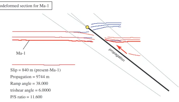
石山達也 既存のボーリング断面図に表現されている(例えば Mitamura et al., 1994;関西地盤情報活用協議会地盤研 究委員会編,1998).また,いくつかの浅層反射法地 震探査によって上町断層にともなう褶曲構造のイメ ージングが行われている(吉川ほか,1987;大阪市, 1997;杉山,1997).杉山(1997)による大和川での 反射法地震探査は,ほぼ海岸線付近に伏在する住之 江撓曲の存在を明らかにした.七山ほか(2001)に よれば,住之江撓曲は,大和川付近において,酸素 同位体比層序のステージ 5 に対比される Ma12 層を 変位させている. 生駒断層帯は,枚方断層・交野断層・田口断層・ 生駒断層および南側に位置する誉田断層から構成さ れる,全長 45km の大規模な逆断層帯である(池田 ほか,2002)(第 1 図).とくに生駒山地西麓の急崖 地形は辻村(1932)により「生駒断層崖」と呼ばれ, 古くからその存在が注目された.しかし,この急崖 地形の基部には必ずしも生駒断層の第四紀後期の活 動性を示唆するような証拠はなく,これよりも平野 側に,新旧の段丘面・扇状地面を変位させる撓曲崖・ 低断層崖といった逆断層にともなう変動地形が顕著 に発達している. 3.上町断層帯の地下構造 3.1 上町断層帯の反射断面 上町断層帯のイメージングを目的とした反射法地 震探査のうち,吉川ほか(1987)によって得られた 「中之島測線」の断面が,活断層である上町断層の 地下構造を推定する上で最も適している(第 2 図). その理由は,①測線が上町台地の北縁部に位置して いるため,地表で認識できる活断層の地下構造とし て捉えることができる,②測線の近傍において,上 町断層の上盤・下盤側に,先新第三系基盤岩類の上 面深度に達するボーリングが存在する,また③これ らのボーリングの一部では大阪層群の層序が明らか になっている,の 3 点である.鮮新―更新統の露出 がほとんどなく,表層地質と反射面の対比が一般に 困難である大阪平野西北部においては,これらの条 件を満たす反射断面は現在のところ,この測線のみ である. 吉川ほか(1987)による中之島測線の位置を第 1 図に,深度断面を第 2 図に示す.上町断層にともな う西向き変形帯は,水平距離 2.5∼3.5 km に認められ る.一方,地表では,水平距離 3 km 付近の南方に, 西向きに撓曲変形する中位段丘面の西縁を断つ段丘 崖が南北方向に発達する.段丘崖以西に広がる沖積 低地面を変位させる変動崖は認められない.一方, 中之島測線の約 1 km 南方,阪神高速 13 号線に沿っ て作成されたボーリング断面図によれば,沖積低地 面下で Ma12 層が西向きの撓曲変形を受けている (Mitamura et al., 1994;関西地盤情報活用協議会編, 1998).これらの断面の位置関係から,沖積低地面下 に伏在する撓曲構造は上町断層帯北部の変形フロン トであり,中之島測線は変形フロントの構造を地下 2 km 程度のスケールで捉えたものと考えられる. 3.2 上町断層帯北部の反射断面の解釈 吉川ほか(1987)の反射断面の近傍には,先新第 三系基盤岩類に到達したボーリング(OD-2:三田村 ほか,1998;江戸堀2丁目:石賀ほか,1994;市原, 1991)や,大阪層群の層序について検討されたボー リング(OD-2:三田村ほか,1998;大手前ボーリン グ:吉川ほか,1998;OD-1:三田村ほか,1998)が 分布する(第 2 図).これらを反射面と対比すると, 断層上盤側・下盤側の先新第三系基盤岩類上面と大 阪層群都島累層および田中累層の分布深度から,大 阪層群全体が上町断層の下盤側で厚い.このことは, 上町断層の断層運動の開始時期が大阪層群都島累層 の堆積開始時期とほぼ同時であることを示している. また,断層の両側で対比される大阪層群田中累層中 の海成粘土層(Ma-1∼Ma4)の分布深度には,西向 き撓曲構造を挟んで明らかに不連続が認められる. これらの対比される地層間の落差は上位ほど小さい. このような構造は,大阪層群が断層運動により地表 面に形成された起伏を埋めるように順次堆積し,地 表に向かって延伸する断層により次々に切られるこ とによって形成されたと考えられる.すなわち,こ の 反 射 断 面 の 撓 曲 構 造 は fault-propagation fold (Suppe and Medwedeff, 1990; Erslev, 1991)であると 解釈される. 3.3 上町断層帯の断層関連褶曲モデル 上町断層帯北部で得られた反射断面(吉川ほか, 1987)と断層の両側に位置するボーリングにより確 認される先新第三系基盤岩類(花崗岩)の分布深度 から,上町断層はその先端が深さ約 0.1 km ないしそ れ以浅に位置する blind thrust であると考えられる. これらを考慮した上で,上町断層の幾何学的形状を 推定するため,trishear fault-propagation fold model (Allmendinger, 1998)によるモデリングを行った(第 3 図).その結果,上町断層の傾斜を約 40º,すべり 量を約 1 km とすれば,大阪層群・田中累層最下部の 海成粘土層である Ma-1 層の堆積構造を復元するこ とができる.この場合, Ma-1 層の推定堆積年代(約 1.2 Ma;内山ほか,2001)から上町断層のすべり速 度は約 0.8 mm/yr となる.この値と断層の傾斜から見 積もられる上下変位速度は田中累層中に挟まれる多 数の海成粘土層から見積もられた上下変位速度(0.4 mm/yr 程度;内山ほか,2001)と整合的である.し たがって,trishear fault-propagation fold model に基づ いて求めた上記の上町断層の形状は,褶曲西翼部の 構造をよく説明するといえる.
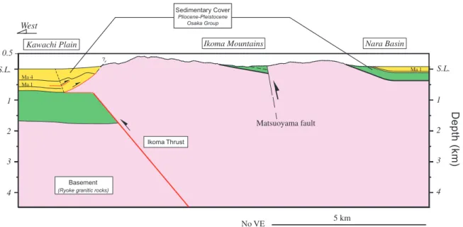
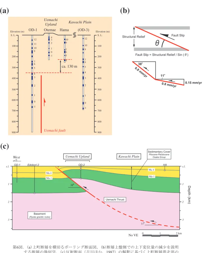
上町・生駒断層帯の地質学的断層−褶曲モデル 生駒断層帯では堀家ほか(1995)および下川ほか (1997)でこれを横切る浅層反射法地震探査が行わ れている.このうち,下川ほか(1997)の結果は生 駒断層帯の変形構造を最もよくあらわしている(第 4 図).しかし,生駒断層帯の上盤側に分布する大阪 層群相当層は露出に乏しく,吉川・三田村(1999) などによる大阪層群の標準層序との対比は困難であ る.生駒山地北東麓部・西麓部に露出する大阪層群 の層序を考慮すると,大阪層群下部・最下部相当層 が生駒山地東麓部に分布する可能性が高いが,その 実態は不明である.したがって,反射断面を用いた 定量的な断層構造の推定は現時点では困難である. 一方,生駒断層帯中部の交野市星田で掘削された 温泉ボーリングは,交野断層と交差し,先新第三系 基盤岩類(花崗岩)が大阪層群に衝上する断層を深 度 640 m と 1016 m で捉えている(太田,1991).こ れらの断層と活断層の地表位置(池田ほか,2002) とを結んだ線を断層面とみなすと,交野断層の傾斜 は 46º から 58º の間になる.このことから,生駒断層帯の 断層面の傾斜は 50∼60º 程度と考えられる. 上記の推定をふまえ,下川ほか(1997)の反射断 面をもとに作成した生駒断層帯の模式的な断面を第 5 図に示す.下川ほか(1997)の反射断面にあらわ れた大阪層群の褶曲構造の上盤側には,progressive limb rotation(例えば Hardy and Ford, 1997)が認めら れ,大阪層群の堆積と同時に褶曲構造が形成された と考えられる.また,重力異常から推定される先新 第三系基盤岩類の分布深度(例えば堀家,1995)か ら,断層面は河内平野下では大阪層群都島累層に衝 上していると推定される.また,大阪層群の層厚は 明らかに断層の下盤側で厚い.このことは,生駒断 層帯の活動開始時期が上町断層帯北部と同じく,大 阪層群の堆積開始時期とほぼ同時であることを示す. また,堀家ほか(1995)や下川ほか(1997)の反射 断面にあらわれた断層上盤側には,顕著な副次的な 東フェルゲンツの層面すべり断層が認められる.こ のうちの一部は,AT 火山灰層を変位させていること がボーリング調査によりわかっている(下川ほか, 1997;第 4 図).このような主断層と逆向きのフェル ゲンツの断層は fault-propagation fold の前翼部に一般 に観察される(例えば Erslev and Mayborn, 1997). 5.大阪平野下の褶曲−衝上断層帯の地下構造 上町断層帯北部の上盤側にあたる河内平野と下盤 側の臨海平野部では,大阪層群田中累層中の中部更 新統から完新統にいたる海成粘土層(Ma-1∼Ma13) の分布深度がほぼ変わらない.すなわち,断層帯北 部の上盤側に分布する上町台地の地下で薄い大阪層 群は,東に向かって層厚を増している.さらに,こ の上町台地は東に傾斜し,沖積低地面(河内平野面) 下に埋没する.したがって,上町断層帯北部は第四 紀を通じて,上町台地付近に東西幅の狭い隆起帯を なしている.このことは,上町断層帯北部が上部地 殻浅部で低角なデコルマ面に収れんする thin-skinned thrust である可能性を示唆している. 河内平野ではいくつかの反射断面が得られている (大阪市,1997;堀家ほか,1995)が,上町断層帯 にともなう褶曲東翼部の構造を明らかにするような 断面は得られていない.したがって,大阪層群の地 質構造を使って,Suppe (1983) などの断層関連褶曲 モデルに基づく cross section balancing(バランス断面 法)を適用して,東翼部地下の断層の形状を推定す ることは不可能である.しかし,断片的に分布する ボーリングコアで確認される大阪層群の分布深度か ら,断層深部の形状を間接的に推定することは可能 である(第 6 図).吉川ほか(1987)による反射断面 の東延長部に位置する浜ボーリング(吉川ほか, 1998)と,上町断層帯下盤側に位置する OD-1 ボー リング(三田村ほか,1998)における Ma 4 層上面の 分布深度の差は,約 130 m である.これに対し,OD-1 ボーリングと上町台地上の大手前ボーリング間の Ma 4 層上面の分布深度の差は約 320 m である.すな わち,Ma 4 層上面を変位基準とする上町断層帯北部 の上下変位量は,断層上盤側で東に向かって減少す る.褶曲東翼部で求めた上町断層帯北部の変位速度 (0.8 mm/yr)が断層面上で一定であると仮定すれば, この上下変位の減少は断層の傾斜の減少によって説 明できる.単純な三角関数を用いると,河内平野下 では断層の傾斜は約 11º と推定される. 生駒断層の上盤側には先新第三系基盤岩類が露出 しており,地質構造が非常に複雑である.したがっ て,断層深部の構造と上盤側の構造を一義的に結び つけることは難しい.そこで,断層下盤側の河内平 野と奈良盆地地下の大阪層群の分布高度から断層深 部 の 形 状 に つ い て 定 性 的 に 考 察 す る . 池 田 ほ か (2002)は生駒断層帯の上下変位速度を 0.5∼0.6 mm/yr と推定している.一方,松岡(1983)によれ ば,奈良盆地中央部に位置するボーリングに含まれ る Ma 1 層上面の分布高度は約-60 m である.これに 対し,断層下盤側にあたる河内平野の OD-3 ボーリ ングでは,Ma 1 層上面は標高約-560 m に確認されて いる(三田村ほか,1998).したがって,両ボーリン グにおける高度差と堆積年代(約 1.1 Ma;吉川・三 田村,1999)から推定される上下変位速度は約 0.5 mm/yr である.この値は池田ほか(2002)が推定し た生駒断層帯の上下変位速度とほぼ等しい.このこ とは,生駒断層帯の上盤側にあたる隆起域が,生駒 山地のみならず奈良盆地まで含むことを示している. すなわち,生駒断層帯は上町断層とは異なり,地下 深部まで一様な傾斜で延びる,いわゆる thick-skinned thrust であることを示唆する(第 5 図). このように,上町断層帯北部と生駒断層帯の地質 構造は,①河内平野下で低角のデコルマ面に収れん する thin-skinned thrust と②高角で上部地殻を断ち切 る thick-skinned thrust で構成される,一連の褶曲−衝
石山達也
上断層帯という構造モデルによって説明される(第
7 図).このような低角の前縁スラストとより高角な
後背地側のスラストの組み合わせは,褶曲−衝上断 層帯において一般的である(例えば Boyer and Elliott, 1982). ただし,今回得られた結果にはいくつかの留意す べき点がある.まず,今回定性的に求めた上町断層 帯北部の深部の形状,すなわちデコルマ面の傾斜や 位置については,データの不足による任意性がある. 通常,断層関連褶曲モデルにおいては,とくに断層 深部の形状を推定するためには,断層上盤側・背斜 後翼部の幾何学的形状に関するデータが不可欠であ る.しかし,上町断層帯北部においては,河内平野 の顕著な沈降のため,この部分の形状が明らかでは ない.今後,定量的に上町断層帯北部の深部の形状 を推定するためには,河内平野を横断する長測線の 反射法地震探査を実施し,断層の上盤側における大 阪層群および先新第三系基盤岩類上面の形状を決定 する必要がある. また,上町断層帯北部について推定した地殻浅部 のデコルマ面が,断層帯南部についても同様に成り 立つか否かは不明である.これまでに上町断層帯南 部でいくつかの反射法地震探査が行われている(杉 山,1997;大阪府,1999)が,断層の形状を推定す るに足る断面は得られていない.上町断層帯南部で は断層の上盤側に台地・丘陵部が広がり,断層に起 因する隆起部の幅が広い.このことは,上町断層帯 南部が北部とは異なり,thick-skinned thrust である可 能性を示す.したがって,上町断層帯の北部と南部 では,断層構造が異なる可能性がある.しかしなが ら,現時点ではこのような断層の 3 次元形状を推定 できるようなデータはない.今回の推定断面はあく まで南北 45km に延びる断層帯の一断面に過ぎない ことに留意する必要がある. 最後に,今回提示した構造モデルを直接検証する ようなデータの取得が今後必要になるであろう.例 えば,Laramide 造山帯では,褶曲−衝上断層帯を構 成するスラストの深部形状を決定するために,バイ ブロサイスを用いた長測線の反射法地震探査が実施 され,上部地殻を断ち切る低角のスラストが検出さ れた(Smithson et al., 1979).上部地殻スケールの震 源断層として活断層を議論する上で,Laramide 造山 帯のような実験をおこなうことが,今後不可欠であ ろう. 6.まとめ 既存の地質図,反射法地震探査断面およびボーリ ングデータを用いて,大阪平野下に伏在する上町断 層帯と生駒断層帯の地下構造について検討した.そ の結果,上町断層帯北部は地殻浅部で低角になる thin-skinned thrust,生駒断層帯は thick-skinned thrust であり,両者は一連の褶曲−衝上断層帯を構成して
いる可能性を指摘した.
謝辞 Trishear fault-propagation model の適用に際し ては Cornell 大学の R. Allemendinger 博士が作成し たプログラムを使用した.記して感謝いたします.
文 献
Allmendinger, R. W. (1998) Inverse and forward numerical modeling of trishear fault-propagation folds. Tectonics, 17, 640-656.
Allmendinger, R. W., (1998) TrishearPPC 3.0. Ithaca, New York, 1998.
Allmendinger, R. W., and J. H. Shaw (2000) Fault nucleation and propagation from fold shape: potential implications for earthquake seismicity.
Geology, 28, 1099-1102.
Boyer, S. E. and Elliot, D. (1982) Thrust systems, AAPG
Bull., 66, 1,196-1.230.
Erslev, E. A. (1991) Trishear fault-propagation folding.
Geology, 19, 617-620.
Erslev, E. A. and Mayborn, K. R. (1997) Multiple geometries and modes of fault-prooagation folding in the Canadian thrust belt. Jour. Structural Geology, 19, 321-335.
Hardy, S. and Ford, M. (1997) Numerical modeling of trishear fault-propagation folding. Tectonics, 16, 841-854. 堀家正則・竹内吉弘・鳥海 勲・藤田 崇・横田 裕・ 野田利一・井川 猛 (1996) 生駒山地と大阪平野 境界部における反射法地震探査. 地震 2, 48, 37-49. 堀家正則・竹内吉弘・今井智士・藤田 崇・横田 裕・ 野田利一・井川 猛 (1996) 大阪平野東部におけ る地下構造探査. 地震 2, 49, 193-203. 池田安隆・今泉俊文・東郷正美・平川一臣・宮内崇 裕・佐藤比呂志編(2002)第四紀逆断層アトラ ス.東京大学出版会,254 p. 石賀裕明・佐藤光男(1991) 深層ボーリングデータに よる大阪平野北部の中・古生界. 地質学雑誌, 97, 675-678. 石賀裕明・佐藤光男・西川和史(1991)大阪平野の 地下地質と温度構造(予報).島根大学地質学研 究報告,13,23-30. 市原 実編(1993) 大阪層群. 創元社, 340 p. 活断層研究会 (1991) 新編日本の活断層−分布図と 資料−.東京大学出版会,437 p. 関西地盤情報活用協議会地盤研究委員会編 (1998) 新関西地盤—神戸および阪神—, 関西地盤情報 活用協議会, 270 p. 松岡数充(1983)奈良盆地のボーリング試料中の大 阪層群について.長崎大学教養部紀要(自然科 学篇),24,23-31.
Mitamura, M., Matsuyama, N., Nakagawa, K., Yamamoto, K., and Suwa, S. (1994) Stratigraphy and subsurface structure of Holocene deposits around Uemachi
上町・生駒断層帯の地質学的断層−褶曲モデル
upland in the central Osaka. Journal of Geosciences,
Osaka City University, 37, 183-212.S
三田村宗樹・吉川周作・石井陽子・貝戸俊一・長橋 良隆(1998)大阪平野 OD ボーリングコアの岩 相.大阪市立自然史博物館研究報告,No. 52,1-20. 宮地良典・田結庄良昭・寒川 旭(2001)大阪東北 部の地質.地域地質研究報告(5 万分の 1 地質図 幅),地質調査所, 130 p. 宮地良典・田結庄良昭・吉川敏之・寒川 旭(1998) 大阪東南部地域の地質.地域地質研究報告(5 万 分の 1 地質図幅),地質調査所, 113 p. 中田 高・今泉俊文編(2002)活断層詳細デジタル マップ.東京大学出版会,60 p. 七山 太・土井康裕・北田奈緒子・竹村恵二・杉山 雄一(2001)大阪平野西部,上町断層系住之江 撓曲の活動度評価とこれに基づく過去 1 万年間 の海水準変動.地質学雑誌,107,215-221. 西岡芳晴・尾崎正紀・寒川 旭・山元孝広・宮地良 典(2001)桜井地域の地質.地域地質研究報告 (5 万分の 1 地質図幅),地質調査所,141 p. 岡田篤正・東郷正美編 (2000) 近畿の活断層.東京大 学出版会, 395 p. 大阪府(1999)平成 10 年度地震関係基礎調査交付金 上町断層帯に関する調査成果報告書. 大阪市 (1997) 上町断層(上町断層帯)に関する調査. 平成 7 年度・平成 8 年度地震調査研究交付金成 果報告会予稿集,90-94. 太田 明(1991)交野断層と温泉開発.日本地質学 会第 98 年学術大会講演要旨, 473. 尾崎正紀・寒川 旭・宮崎一博・西岡芳晴・宮地良 典・竹内圭史・田口雄作(2000)奈良地域の地 質.地域地質研究報告(5 万分の 1 地質図幅), 地質調査所,162 p. 下川浩一・苅谷愛彦・宮地良典・寒川 旭(1997) 生駒断層系の活動性調査.平成 8 年度活断層研 究調査概要報告書,地質調査所研究資料集, No. 303,37-49. 杉山雄一 (1997) 上町断層系の反射法弾性波探査.平 成 8 年度活断層研究調査概要報告書,地質調査 所研究資料集, No. 303, 105-113.
Smithson, S. B., Brewer, J. A., Kaufman, S., Oliver, J. E., and Hurich, C. A. (1979) Structure of the Laramide Wind River uplift, Wyoming, from COCORP deep reflection data and from gravity data. Jour. Geophys.
Res., 84, 5, 955-5,972.
Suppe, J. (1983) Geometry and kinematics of fault-bend folding. American Journal of Science, 283, 684-721. Suppe, J. and Medwedeff, D. (1990) Geometry and
kinematics of fault-propagation folding. Eclogae
Geologicae Helvetiae, 83, 409-454. 辻村太郎(1932)東北日本の断層盆地.地理学評論, 8,641-658,747-760,977-992. 内山美恵子・三田村宗樹・吉川周作(2001)大阪平 野中央部,上町断層の変位速度と基盤ブロック の運動.地質学雑誌,107,228-236. 吉川周作・三田村宗樹・中川康一・長橋良隆・岩崎 好規・越後智雄・辻江賢治・北田奈緒子(1998) 大阪市津守・大手前・浜ボーリングの岩相・火 山灰層序.地質学雑誌,104,462-476. 吉川周作・三田村宗樹(1999)大阪平野第四系層序 と深海底の酸素同位体比層序との対比.地質学 雑誌,105,332-340. 吉川宗治・町田義之・寺本光雄・横田裕・長尾英孝・ 梶原正章 (1987) 大阪市内における反射法地震 探査.物理探査学会第 77 回学術講演会論文集, 114-117. (受付:2003 年 9 月 19 日,受理:2003 年 10 月 8 日)
石山達也 石山達也
大阪平野下に伏在する上町および生駒断層帯の地質学的断層-褶曲モデル 大阪平野下に伏在する上町および生駒断層帯の地質学的断層-褶曲モデル Ta na ka F m . M iy ak oj im a F m . M iy ak oj im a F m . s. l. 1 km s. l. 1 km 1k m gr an iti c ba se m en t gr an iti c ba se m en t N o V E ;M ig ra te d, de pt h E do bo ri-2 E do bo ri-2 O D -1 O D -2 O T Ta na ka F m . s. l. 1 km s. l. 1 km 1k m
E
as
t
E
as
t
N o V E ;M ig ra te d, de pt h(a
)
(b
)
M a-1 M a 4 M a 1 M a-1 M a 4 M a 1 第 2 図 . (a ) 吉 川 ほ か ( 19 87 ) に よ る 上 町 断 層 の 反 射 法 地 震 探 査 の 深 度 断 面 , (b ) そ の 解 釈 図 . 断 面 お よ び ボ ー リ ン グ の 位 置 は 第 1 図 に 示 す . 断 面 の 縦 横 比 は 1 : 1 . Fi g. 2. (a ) D ep th ,m ig ra te d se is m ic pr of ile ac ro ss th e U em ac hi fa ul ta cq ui re d by Y os hi ka w a et al .( 19 87 ). (b ) In te rp re te d de pt h se is m ic pr of ile ac ro ss th e U em ac hi fa ul t, co ns tr ai ne d by bo re ho le s. L oc at io ns of th e pr of ile an d bo re ho le s ar e sh ow n on Fi g. 1. N o ve rt ic al ex ag ge ra tio n. 第1図.(a) 近畿地域の活断層図.活断層の位置は池田ほか編(2002)および中田・今泉編(2002)に基づく.陰影図は 国土地理院発行の250 m DEMを使用して作成した.図中の略称は以下の通り:OS:大阪市,KT:京都市,NG:名 古屋市.図中の星印は1995年兵庫県南部地震の震央位置を示す. (b) 大阪平野北部の地質図.地質図は尾崎ほか(2000),西岡ほか(2001),宮地ほか(1998)および宮地ほか (2001)を改変.活断層の位置は池田ほか編(2002)に基づく. オレンジ色の太線は,第7図に示す東西地質断面 図の投影線である.Fig. 1. (a) A shaded relief map based on a 250 m digital elevation model, showing the topography and distribution of active faults within Kinki region, central Japan. Locations of active faults are from Ikeda et al. (2002) and Nakata and Imaizumi (2002). Note a major compressional termination of the eastern end of the strike-slip active MTL, which corresponds with the northern end of higher topographic domains of the Outer Belt. The Kinki region north of the MTL is characterized by an array of N-trending active thrusts juxtaposed with Neogene basins. Abbreviations for cities are as follows: OK: Osaka, KT: Kyoto, NG: Nagoya. Asterisk indicates the hypocenter of the disastrous 1995 Hyogo-ken Nanbu (Kobe) earthquake (MJMA7.2).
(b) Geologic map of the northern Osaka plain with locations of active fault and fold scarps, modified from Miyachi et al. (1998), Miyachi et al. (2001), Nishioka et al. (2001), and Ozaki et al. (2000). Locations of active faults are from Ikeda et al. (2002). Location of seismic sections and boreholes is also shown. Abbreviations for borehole locations are: HA: Hama
石山達也 石山達也
Retrodeformed section for Ma-1
Slip = 840 m (present-Ma-1) Propagation = 9744 m Ramp angle = 38.000 trishear angle = 6.0000 P/S ratio = 11.600 pro pag ation Ma-1
(a)
synclinal axial surface synclinal axial surface
2.0 1.5 1.0 0.5 0 2.0 1.5 1.0 0.5 0 Tw o W ay Tr av el T im e (s ec o n d s) CMP Numbers 10 100 200 300 400 500 600 700 800 900 1000 1050 W 1 km
Total survey line length 2,900 m (1,500 + 1,400 m) Source Impactor (JMI-200) Observation system BISON 9060-A Geophone resonant frequency unknown Geophone / station 6 Channels 60 Source vibration / record 20 Shot interval 5 m Station spacing 10 m Recording time length 2.5 s Sampling interval 1 ms Parameters for seismic data collection
第3図.上町断層の反射断面(吉川ほか, 1987)の解釈を説明する,trishear fault-propagation fold
(Allmendinger, 1998)に基づく断層モデル.
Fig. 3. Trishear solution for the Uemachi fault imaged in the seismic profile acquired by Yoshikawa et al. (1987). Numerical code of Trishear PPC is used courtesy of R. W. Allmendinger. Uplift rate of the Uemachi fault (0.4 mm/yr) estimated from age of the key horizon, ramp angle, and the amount of slip is consistent with those estimated by Uchiyama et al. (2001).
第4図(a).下川ほか(1997)による生駒断層の反射法地震探査の深度断面.断面の縦横比は1:1.
大阪平野下に伏在する上町および生駒断層帯の地質学的断層-褶曲モデル 大阪平野下に伏在する上町および生駒断層帯の地質学的断層-褶曲モデル
GS Yao line, filtered stack section
synclinal axial surface synclinal axial surface
2.0 1.5 1.0 0.5 0 2.0 1.5 1.0 0.5 0 Tw o W ay Tr av el T im e (s ec o n d s) CMP Numbers 10 100 200 300 400 500 600 700 800 900 1000 1050 W Basement (Ryoke granitic rocks)
FW cutoff downward terminating kink band
downward projection of the top of the granitic basement
Basement (Ryoke granitic rocks) roughly determined by density structure based on Bouguer anomaly
1 km Hindward verging
flexural slip fault
Out-of-syncline thrust
Growth triangle
W-facing fold scarp E-facing scarp W-facing fold scarp
Subhorizontal reflections beneath the basement
3.5 km SW OD-3 4 5 6 7 9 10 12 -1 0 1 2 3
Top Miyakojima Formation Top Ryoke Granite
500 510 520 430 440 450 460 470 480 490 AT volcanic ash 50 m 10 m
(b)
第4図(b).下川ほか(1997)による生駒断層の反射断面(深度断面)の解釈図.断面および ボーリングの位置は第1図に示す.断面の縦横比は1:1.Fig. 4(b). Interpreted depth seismic profile across the Ikoma fault, constrained by boreholes. Locations
West Nara Basin D ep th (k m ) Basement
(Ryoke granitic rocks)
Ikoma Thrust Ikoma Mountains 0.5 ? S.L. 1 2 3 4 Matsuoyama fault 5 km No VE S.L. 1 2 3 4 Sedimentary Cover Pliocene-Pleistocene Osaka Group Kawachi Plain Ma 1 Ma 4 Ma 1 第5図.反射断面(下川ほか,1997)の解釈に基づく生駒断層の模式断面図.
石山達也 石山達也 s.l. 1 2 3 s.l. 1 2 3 Edobori-2 OD-1 OD-2 HA Basement
(Ryoke granitic rocks) ? D ep th (k m ) West No VE 0 1 2 km Ma-1 Ma-1 Ma 4 Ma 4 38
Uemachi Upland Kawachi Plain
Uemachi Upland
OD-1 Otemae Hama (OD-3)
4 5 6 7 9 10 -1 0 1 2 3 4 4 5 6 7 9 10 11 12 -1 0 1 2 3 4 5 6 7 9 10 12 -1 0 1 2 3 Elevation (m) S. L. 100 200 300 400 500 600 700 800 900 Elevation (m) S. L. 100 200 300 400 500 600 700 800 900 ca. 130 m Kawachi Plain Uemachi fault
θ
Fault SlipFault Slip = Structural Relief / Sin (θ)
0.15 mm/yr 0.8 mm /yr 0.8 mm/yr 38 11 Structural Relief
(a)
(c)
(b)
Sedimentary Cover Pliocene-Pleistocene Osaka Group Uemachi Thrust 11 第6図.(a)上町断層を横切るボーリング断面図,(b)断層上盤側での上下変位量の減少を説明 する断層の幾何学,(c)反射断面(吉川ほか,1987)の解釈に基づく上町断層帯北部の 模式断面図.Fig. 6. (a) Borehole transect across the Uemachi fault. (b) Cartoon illustrating the relationship between a decreasing uplift rate and a thrust trajectory. (c) Schematic, geologic cross section across the northern Uemachi fault zone, based on the interpreted seismic section.
大阪平野下に伏在する上町および生駒断層帯の地質学的断層-褶曲モデル 大阪平野下に伏在する上町および生駒断層帯の地質学的断層-褶曲モデル