Residential Land use and Housing Development in Indonesia from the Perspective of
Sustainable Urban Form
著者 ピンド ツツコ
著者別表示 Pindo Tutuko journal or
publication title
博士論文本文Full 学位授与番号 13301甲第4159号
学位名 博士(学術)
学位授与年月日 2014‑09‑26
URL http://hdl.handle.net/2297/40520
Creative Commons : 表示 ‑ 非営利 ‑ 改変禁止 http://creativecommons.org/licenses/by‑nc‑nd/3.0/deed.ja
Residential Land Use and Housing Development in Indonesia from the Perspective of Sustainable Urban
Form
Pindo Tutuko
September, 2014
Dissertation
Residential Land Use and Housing Development in Indonesia from the Perspective of Sustainable
Urban Form
Graduate School of
Natural Science and Technology Kanazawa University
Major subject: Environmental Science Course: Environmental Planning
School registration No.: 1123142416 Name: Pindo Tutuko
Chief advisor: Professor Zhenjiang Shen
i
Abstract
This PhD research targets to find the solution for housing development in Indone- sia to achieve sustainable Urban Form through land use control on residential land use.
Start from the review on the spatial planning in Indonesia, this PhD dissertation introduces the spatial planning system in Indonesia and its implementation in Suraba- ya city. Further, we focus on traditional life style, this research attempts to present the adaptability of dwellers to arrange their house. Dwellers tend to adjust their spatial setting in order to accommodate domestic activities. We have studied a settlement area which has kampong characteristics by strong Javanese influence. There are several individual variations and differentiations in the area, especially on the function of rooms and the implications on spatial arrangement. Javanese cultural characteris- tics are mostly unchanged. This part discusses a study about Javanese perceptions of rooms in the house and their perceptions of the flexibility of the rooms.
The strength of tradition supports the element of stability from one generation to another. In the case of housing pattern where traditions will generally be passed on to the next generation, we use vernacular approach. Tradition is still maintained when utilizing the home as a Home-based Enterprise (HBE). HBE developments are based on a family’s economic growth rate and their living needs. In homogeneous houses, it appears that there is vernacular activity in building or repairing homes. As an example, in the case of HBEs, housing activities are maintained during the process of urban growth. Houses need to be expanded according to the needs of livings and business activities within a limited urban area. In this research the pattern of house develop- ment based on vernacular HBEs, encompassing both living activities and business activities, has been investigated.
In the scope of Land Use Zoning (LUZ) is necessary to control the housing de-
velopment in residential use. In the case of The LUZ in Indonesia, there is not enough
categories in determining the different types of land use for residential use. Due to the
housing development, the urban sprawl taking place in fringe areas has rapidly
increased. It leads the problems of despairing rural housing and decreasing production
of natural resources due to social inequality in the rapid development process. There-
fore, in achieving a sustainable urban form, this project is conducted with zoning
review in the border area, especially in the area that contains the project-based hous-
ii
ing and home owner-based housing. The existing zoning does not distinguish between project-based housing development and home owner-based housing development. A clear line between different types of residential use is suggested in order to provide a basis for planners and developers in the construction of project-based housing without disturbing the home owner-based housing for a sustainable urban form.
Keywords: Boundary, Depth Ratio, Housing Pattern, Javanese House, Land Use
Zoning, Life Style, Residential Housing Development, Spatial Planning,
Spatial Arrangement, Sustainable Urban Form.
iii
Acknowledgments
I am grateful to all those who directly and indirectly contributed for the success- ful achievement of this work.
I would like to thank to Allah SWT who give opportunity to finish my Doctoral study in Kanazawa University, Japan promptly and my Family (my wife Diyah Sukanti Cahyaningsih, my daughter Dara Citra Saraswati Tutuko, my son Ario Bagus Kusumadewa Tutuko, and my daughter Putri Kinanti Ayu Hapsari Tutuko).
The most heartfelt thanks go to my supervisor, Prof. Shen Zhenjiang, Prof. Ka- wakami Mitsuhiko, Prof. Itoh Satoru and Prof. Chikata Yasuo. Their immeasurable support, constant incentive and guidance were crucial for the development of this thesis.
I would like to thank Associate Prof. Nishino Tatsuya for being members of my dissertation review panel and for all valuable comment they provided.
My sincere and thanks go to Dr. Kobayashi Fumihiko for help and valuable ad- vices.
I also would like to thank the Urban Planning Laboratory for the support and physical conditions it provided for the development of this research. I should also thank the help and support of my friends at the Urban Planning Laboratory.
I am very grateful to the reviewers for the comments on manuscript and also DIKTI-scholarship of Republic of Indonesia. I would like to thank to entire people in Magersari, Yogyakarta, Indonesia; Sanan, Malang, Indonesia; residents of Pondok Tjandra Indah, Tambaksumur villager and officer of BAPPEDA Sidoarjo, Indonesia.
for giving information about study area, Tracey Taylor who has helped to improve this dissertation, and Mr. Tristiyanto who has helped to make House Depth Calcula- tion Tool.
Last, but not least, I would like to thank my friends in Kanazawa, DIKTI-KU Group, and PPI Ishikawa for their constant support and encouragement throughout my academic life.
Thank You!
iv
Contents
Abstract ... i
Acknowledgments... iii
Chapter 1 : Introduction ... 1
1.1 Background ... 1
1.2 Objectives ... 2
1.3 Literature Review ... 2
1.3.1 Residential Housing Development ... 2
1.3.2 Sustainable Urban Form ... 3
1.4 Research Method and Thesis Organization ... 4
Chapter 2 : City Planning of Indonesia for Natural Resource and Preservation Efforts ... 7
2.1 Introduction ... 7
2.2 Spatial Planning System ... 8
2.3 Green City Design Approach for Global Warming Anticipatory ... 10
2.4 Green City Design ... 11
2.5 Surabaya`s Development Plan and Urbanization ... 14
2.5.1 Case Study City ... 14
2.6 Urbanization in Surabaya ... 15
2.7 Planning Issue in Urbanization Process ... 17
2.8 Green City Design in Ecological System of Surabaya ... 20
2.8.1 Ecological System ... 20
2.8.2 Toward green city design: spatial structure and patterns ... 21
2.8.3 Discussion of Surabaya`s Planning Practice ... 24
2.9 Conclusion in this chapter ... 26
Chapter 3 : The Spatial Arrangement Based on the Javanese Tradition to Determine The Flexibility of The House ... 27
3.1 Introduction ... 27
3.2 Research Area ... 29
v
3.2.1 Overview ... 29
3.2.2 Physical Condition ... 32
3.3 Methodology ... 35
3.3.1 Justified Graph ... 36
3.3.2 Research Plan of the Spatial Arrangement on Javanese House ... 37
3.4 Spatial Arrangement present in the Basic Javanese House ... 38
3.4.1 Analysis of Basic Javanese house ... 39
3.4.2 Analysis of Existing Javanese Houses ... 41
3.5 Results ... 43
3.6 Discussion ... 44
3.7 Conclusion in this chapter ... 45
Chapter 4 : Vernacular Pattern of House Development on Home-based Enterprises... 47
4.1 Introduction ... 47
4.2 Research Approach ... 50
4.3 HBE Housing Patterns in Kampong Sanan ... 51
4.3.1 House Development in Case Study Area ... 52
4.3.2 Typical Vernacular Housing Pattern ... 56
4.4 Locations and Housing Patterns of HBE ... 60
4.4.1 Houses located far from the main road ... 60
4.4.2 Houses located near the main road ... 61
4.5 Conclusion in this chapter ... 62
Chapter 5 : The Effect of Land Use Zonings on Housing Development in Indonesia ... 64
5.1 Introduction ... 64
5.2 Approach ... 66
5.3 Zoning System of Indonesia ... 70
5.4 Local Government Policy ... 71
5.4.1 Land use zoning in Sidoarjo-Surabaya, Indonesia ... 72
5.4.2 Expansion Development ... 74
vi
5.4.3 Existing Condition in Tambaksumur Village ... 77
5.4.4 Pattern of Housing Parcels ... 80
5.5 CDL in Tambaksumur Village ... 83
5.6 Discussion ... 86
5.7 Conclusion in this chapter ... 88
Chapter 6 : Conclusion ... 90
Publications: ... 93
Appendix: ... 94
A. Data from Respondents ... 94
B. Statistic Data ... 97
C. Sketches of Houses ... 99
References ... 101
vii
List of Figures
Figure 2-1 Map of Indonesia ... 8
Figure 2-2 Socioeconomic Planning System. ... 8
Figure 2-3 Spatial Planning System. ... 9
Figure 2-4 Geographical position of Surabaya city as Case... 15
Figure 2-5 Graph of Surabaya Population Prediction per Sub Region. ... 17
Figure 2-6 Surabaya City Spatial Plan 2009-2029. ... 18
Figure 2-7 Major Opportunity Development of Surabaya 2009-2029. ... 18
Figure 2-8 Local protected Areas of Surabaya 2029 (1). ... 19
Figure 2-9 Local protected Areas of Surabaya 2029 (2). ... 19
Figure 2-10 Seaport development of Lamong Bay Waterfront City. ... 21
Figure 2-11 Determination of Surabaya Strategic Plan Area 2029. ... 24
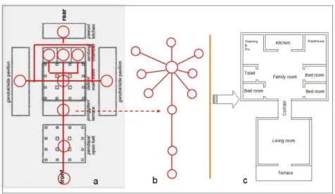
Figure 3-1. Map of Yogyakarta City and aerial view of Yogyakarta Palace. ... 29
Figure 3-2 The housing condition in RFYP. ... 31
Figure 3-3 The Residential area along the Fort of Yogyakarta Palace (RFYP) ... 32
Figure 3-4 Plan and section of semi vertical building ... 34
Figure 3-5. Sketch of houses along the palace of Yogyakarta ... 35
Figure 3-6. Justified Graph on Dalton and Dalton (2007)... 36
Figure 3-7. Research Plan of the Spatial Arrangement on Javanese House. ... 37
Figure 3-8. The arrangement of spaces in Javanese House and The schematic section of Javanese house ... 38
Figure 3-9. The pattern of the relationship between rooms on the Basic Javanese House ... 39
Figure 3-10. Justified Graph of Total Depth (TD) on Javanese House. ... 39
Figure 3-11. Notes of Depth Calculation. ... 40
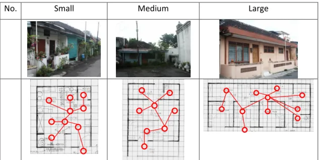
Figure 3-12. Statistical data houses examined in the field. ... 42
Figure 3-13. House Depth Calculation Tool. ... 43
Figure 3-14. Result on LDH, MDH, and HDH about ratio flexibility. ... 43
Figure 3-15. Radar chart on LDH, MDH, and HDH about ratio flexibility. ... 44
Figure 3-16. The relationship illustration on Public-Private space. ... 45
Figure 4-1. An Approach to the Pattern of House Development on HBE. ... 51
Figure 4-2. Kampong Sanan Boundaries... 53
viii
Figure 4-3. Three Groups of Resident in Kampong Sanan. ... 53
Figure 4-4. House Plan, before and after daughter’s marriage... 57
Figure 4-5. Figure regarding early development. ... 59
Figure 4-6. Figure regarding possible development. ... 59
Figure 4-7. The kitchen is at the rear and is always determined as a business zone. .. 60
Figure 4-8. The house located near main street. ... 61
Figure 5-1. Diagram of occupation by project-based housing development on home owner-based housing. ... 67
Figure 5-2. Diagram of Housing development in urban fringe. ... 69
Figure 5-3. Diagram of spatial planning system in Indonesia. ... 70
Figure 5-4. Linkage system between Sidoarjo and Surabaya. Source: Sidoarjo City Master Plan 1984-2004 ... 73
Figure 5-5. Industrial and Settlements Condition between Surabaya-Sidoarjo area. .. 74
Figure 5-6. The Trigger of City Development. ... 74
Figure 5-7. Growth generator at Waru-Surabaya, Gray area indicates the spread of housing and the color red is the focal point of growth. ... 75
Figure 5-8. The road patterns surround Waru-Surabaya ... 76
Figure 5-9. Zoning plan at Tambaksumur Village. ... 77
Figure 5-10. Land use zoning in Tambaksumur Village area (combination of aerial photo layer and land use maps). ... 77
Figure 5-11. Aerial photographs of formal housing and informal housing (Pondok Tjandra Indah & Village Tambaksumur, Sidoarjo City). ... 78
Figure 5-12. a). Different Pattern between Tambaksumur Village and Pondok Tjandra Indah Housing (PTIH). b) Housing Pattern (linear) of Tambaksumur Village. ... 79
Figure 5-13. The main road that is influenced by project-based housing development, which is indicated by access connecting both housing areas. ... 80
Figure 5-14. Grid and Linear Pattern. ... 81
Figure 5-15. The difference between project-based housing parcel patterns and home owner-based housing. ... 82
Figure 5-16. The map of District Waru, Sidoarjo, 1963. ... 83
Figure 5-17. The boundary line in the same colour coding scheme on residential use parcel. ... 84
Figure 5-18. The CDL factors on housing development in Tambaksumur village. .... 85
Figure 5-19. The CDL factors in every part of home owner-based housing. ... 86
ix
List of Tables
Table 3-1 Dweller Perception Regarding Kraton’s Regulations. ... 31
Table 3-2 Percentage of Building Coverage Area ... 33
Table 3-3 Grouping house and examine the interaction between the rooms. ... 41
Table 4-1. The Economic Level and housing Condition. ... 53
Table 4-2. Relationships between ownership status, income per-month, and other finance. ... 54
Table 4-3. Relationship between Ownership status, Development Status, Income and Finance resources. ... 55
Table 4-4. Relationships between ownership status, duration of business in the kampong, and the reason for keeping the business. ... 55
Table 4-5. Summary the influence of house status, main factor, and duration of doing business to development status. ... 56
Table 4-6. The relationship between influencer, the reason for the renovation, and part will be maintained. ... 58
Table 5-1. The factors for CDL in home owner-based housing and project-based housing development. ... 68
Table 5-2. The recovering area for the development of residential. ... 72
Table 5-3. Growth generator in Sidoarjo from 1970-2000. ... 75
Table 5-4. Aspect of CDL on Tambaksumur... 84
x
List of Equations
Equation 3-1 BDRlr ... 40
Equation 3-2 BDRfr ... 40
Equation 3-3 BDRk... 40
Equation 3-4 Average Depth ... 42
Equation 3-5 Depth Ratio for Living Room ... 42
Equation 3-6 Depth Ratio for Family Room ... 42
Equation 3-7 Depth Ratio for Kitchen ... 42
1
Chapter 1 : Introduction
In developing countries, the housing development has problems caused by the lack of proper planning. The one of issue in urban planning is sustainable urban form.
In term of spatial planning, we introduce the practice of Spatial Planning in Indonesia on the aspects of urban planning and design related to the natural resource and sub- urbs preservation efforts. This research focus on the residential housing development regard to Sustainable Urban Form starts from lifestyle in a house that is influenced by tradition, next manifested in the determination of the pattern of house development that are also influenced by the tradition that runs from generation to generation. This research will also consider the need to maintain home owner-based housing develop- ment that need to be given a clear line for the project-based housing development.
This dissertation is the research result on study about the implementation and devel- opment of housing in Indonesia, with a case study in Surabaya city, Sidoarjo city, Malang city, and Yogyakarta city, Indonesia.
1.1 Background
Focus on owner perception to improve their house by room’s flexibility, com- monly Indonesian people build their own house gradually and reflecting behavioral occupying of dwellers. This dissertation also attempts to present about adaptability of dweller to arrange their house. The dweller tends to adjust their spatial setting in order to accommodate domestic activities. In this case, the housing development needs to maintain the specific regulation of the palace as a representative of Javanese Culture.
The research took place at a settlement which has kampong character. There are several of individual variability and differentiation on that area, especially on function of room and the implication on spatial arrangement.
Furthermore, in the case of home owner-based housing, the owner needs the pro- cess of building and maintaining their houses. Almost Indonesian people use the strength of tradition to support the stability from one generation to another. It shown that group of people in the urban area maintains their traditions to the next generation.
Tradition is still maintained when utilizing the home as a Home-based Enterprise
(HBE). HBE developments are based on a family’s economic growth rate and also
2
consider their household needs. In homogeneous houses, it appears that there is vernacular activity in building or repairing homes. As an example, in the case of HBEs, housing activities are maintained during the process of urban growth.
Further, in the context of residential area, the home owner-based house expanded by the project-based housing development. Home owner-based house needs to be sustained in order to achieve the desired urban form. In the context of city planning, residential areas cannot be separated from the Land Use Zoning (LUZ), because it necessary to control the urban land use. In the term of LUZ in Indonesia, there are not enough categories in determining the different types of land allotment for housing use.
Due to the housing development, the urban sprawl took mostly place in fringe areas.
In achieving a sustainable urban form in urban fringe, this research is conducted with zoning review in the border area, especially in the area that contains the project-based housing and home owner-based housing.
1.2 Objectives
Based on the problems above, this dissertation has some objectives to give the so- lution, there are:
1. Determining on flexibility of rooms to support housing development and ex- plain the decision of spatial arrangement in the house in the urban area.
2. The pattern of house development based on vernacular HBEs Houses need to be expanded according to the needs of living and business activities within a limited urban area.
3. A clear line between different types of residential use is suggested in order to provide a basis for planners and developers in the construction of project- based housing without disturbing the home owner-based housing for a sustain- able urban form.
1.3 Literature Review
1.3.1 Residential Housing Development
A settlement is a residential place of activities that support human life. According
to Newmark and Thompson (1977) and Silas (1993) about the terminology of house
as shelter, house, and home; According to the function of the house is not just for
shelter, rest, and family (residential), but it also can serve as a mobilized resource for
3
the occupants. According to Ferguson and Smets (2010), Bredenoord and Lindert (2010), and Abbot (2002a), resources dedicated to incremental housing have to compete with other needs of the household. In addition, Sarwono (1992) states that humans will always adjust the environment by considering the feasibility elements for human habitation which are related to human needs. On the other hand, Samadhi (2004) said, the norm is also a consideration in determining the direction of house development.
Furthermore, some studies about several aspects to discuss about housing im- provements such as: (1) Low building quality and slow development in the process of construction of the house. (Kowaltowski (1998); Bredenoord and Lindert (2010);
Abbot (2002a); Abbot (2002b); Ferguson and Smets (2010); Shiferaw (1998); Al- Naim and Mahmud (2007); Kigochie (2001); Sullivan and Ward (2012); Tipple (2004)), (2) The ability and motivation of households to improve their house (Kellett and Granham (1995); Ghafur (2002); Gough and Kellett (2001); Mukhija (2001)), (3) The symbiotic connection between house and economy, such as HBEs (Onyebueke (2001); Sinai (1998); Coen, Ross, et al. (2008)). (4) The concept of housing (Turner (1972))
Focus on life style to the housing development, Supriyadi, Sudarwanto, et al.
(2012), Ahmad, Sultan, et al. (2002). and Anggraini (2012), discussed about lifestyles and increasing households from the original family size were taken into consideration This research also study on the process of generating the spatial configuration and vernacular characteristics regard to Boutabba and Farhi (2011), Aziz and Shawket (2011), and Rapoport (1969).
In deep study about the flexibility of rooms, we use space syntax graphs which focus on discussing spatial arrangement by Anggraini (2012), Omar, Endut, et al, (2011), Boutabba and Farhi (2011), (Dawson (2002), Jeong and Ban (2011), and Kigawa (2003).
1.3.2 Sustainable Urban Form
According to Agenda 21 for Indonesia (1997), housing and settlement develop-
ment goals are to support economic activity in a coherent system that ensures the
preservation of the carrying capacity of the environment and natural resources, so that
4
all layers and segments of society that grew and evolved by these activities are embodied in settlements which support sustainable qualities.
To achieve sustainable urban form we adapt some studies about spatial pattern of human settlement by social norms and cultural setting (Nunta and Sahachaisaeree (2012)), transformed in line with the modern community (Saleh (2000); Saleh (2001)), and from the view of behavior and satisfaction of living (Marmot (1983), Lewis (1997), Chuo and Lee (2011), and Wang and Chien (1999)).
Discussion on sustainable urban form also focused on city planning, by provid- ing clear boundaries for project-based housing development through land use plan as a tool of urban planning could control the provision of land and buildings (Mark and Goldberg (1986), Assche and Djanibekov (2012), Haughton (1997), Magliocca, McConnell, et al. (2012), Wu and Webster (1998), Grieson and White (1981), Wal- lace (1988), and Borges, Fragoso, et al. (2010). We also study about urban fringe that is expanded by urban sprawl (Yokohari, Brown, et al. (1994); Haregeweyn, Fikadu, et al. (2012); Amsalu, Stroonijder, et al. (2007) Nellis and Maca (1986); Tai-Yang, Xian-Jin, et al, (2011); Saint-Macarya, Keil, et al, (2010); Zhang (2001); Zhao (2010);
Lestrelin (2010); Aguilar and Santos (2011); Gennaio, Hersperger, et al, (2009);
Poelmans and Rompaey (2009)) and the effect of project-based housing development (Tse (2001); Sullivan (1984); Weaver and Lawton (2001); Shahraki, Sauri, et al.
(2011)).
Understanding both project-based housing development and home owner-based housing condition are important to know the pattern of land cover and land use changes and their environmental and social implications on spatial planning (Lopez, Boccoa, et al. (2001); Firman and Dharmapatni (1994); Firman (2002); Firman (2004)). Land cover were influenced by historical land, protected area management, land use histories, local culture, affordability, the socio-economic conditions and community involvement are important in understanding land cover change (Muriuki, Seabrook, et al. (2011); Sivam (2002)).
1.4 Research Method and Thesis Organization
In the beginning, we start to introduce the spatial planning in Indonesia, from
here it will be give first understanding about spatial system in Indonesia and its
regulation related to the land use zoning. Then, we study the effort of the city facing
5
the problem about global warming. This is important knowing how a city effort on its planning can preserve natural resource to achieve sustained urban form. Next, this PhD research focused on the problems like life style, spatial arrangement, vernacular pattern of house development, determining clear line between project-based housing development and owner-based housing development.
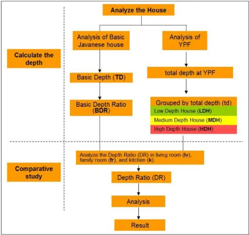
First, to consider about room`s flexibility, This PhD research approach was using space syntax method by graph-based theory to examine how the spatial layout of house. For this study, it is first necessary to determine the depth of the Basic Javanese House and then calculate the depth of Javanese houses that exist at the sites (research conducted in Yogyakarta city).
Secondly, we conducted the vernacular studies to deal with requirement such as sustainability. Because this housing is homogeneous, the considerations for the new construction of the house are similar (research conducted in Malang city). To capture the aspects that result in this similarity, questionnaires to residents were used as an investigative tool for data collection. This investigation took aspects of the tradition, business processes, and living activities into consideration.
Finally, conducted review for effects of LUZ on housing development. The sam- pling was taken in the border area of Surabaya and Sidoarjo. Data took from the local government documents, housing developers, and Tambaksumur village officers. The field data took from the interviews and photos are able to map out the situation there.
The steps in this research is to conduct a review of the implementation of LUZ in Indonesia and later explored more in the application of land use zoning in border cities of Surabaya and Sidoarjo.
The research results are the formula to determining flexibility of particular rooms in order to understanding the relationship between space requirements and cultural phenomena is needed, the pattern of house development, and Co-existing Dividing Line (CDL), CDL on LUZ is effective in achieving co-existing development on border area.
The whole research is organized in to 5 Chapters. We started from Chapter 1 for
Introduction and following it we will introduce the residential housing development in
Indonesia from the perspective of sustainable urban form we mentioned in introduc-
tion part. They are, respectively, Chapter 2 about City Planning of Indonesia for
Natural Resource and Suburbs Preservation Efforts; Chapter 3 about The Spatial
arrangement based on the Javanese tradition to determine the flexibility of the room;
6
Chapter 4 about Vernacular Pattern of House Development on Home-based Enterpris- es; Chapter 5 about The Effect of Land Use Zonings on Housing Development in Indonesia; Last, we make a conclusion on this PhD research in Chapter 6.
7
Chapter 2 : City Planning of Indonesia for Natural Resource and Preservation
Efforts
This chapter aims to introduce the spatial planning in Indonesia and review the planning practice in Surabaya city from the concept of green city design approach, which is recognized as one of planning measures to anticipate problems of global warming that becomes a comment discussion in urbanization process across the cities in the world. The study was conducted by analyzing the designs of Long-Term Development Plan of 2005-2025 and Spatial Planning of Surabaya 2009- 2029 (Hereafter Surabaya’s development plan). We are concerned with the aspects of urban planning and design related to the natural resource and suburbs preservation efforts, as well as consistency between development policies in urbanization process in Indonesia.
2.1 Introduction
Republic of Indonesia is the largest country in South East Asia which has more
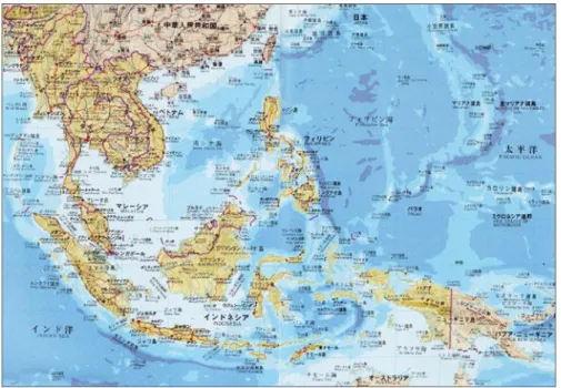
than 17,500 islands (Figure 2-1). There are about 6,000 inhabited islands in an area of
about 700,000 square kilometers (38% of total land area). Population of Indonesia is
the fourth largest country in the world after China, India, and the United States, the
unbalanced population where about 70% of the Indonesian population lives in Java
(6% of the land area).
8
Figure 2-1 Map of Indonesia
Source: Ministry of Land, Infrastructure, Transport and Tourism, Japan (MILT (2008))
2.2 Spatial Planning System
Indonesian Government is composed of 34 provinces, 511 in cities levels (414 cities and 97 counties) and 79,702 villages. At each level of local government has the authority to regulate their respective regions (social and economic) in accordance with the National Development Planning System Law (Law No. 25/2004) and spatial planning in accordance with the Spatial Planning Act (Act No. 26/2007) , then any development in this country based on plans have been made in each area.
Figure 2-2 Socioeconomic Planning System.
Source: Ministry of Land, Infrastructure, Transport and Tourism, Japan (MILT (2008))
9
Indonesian state in conducting socio-economic planning at the national level con- sists of a long-term national development plan (20 years) and five-year development plan; it is also reinforced by the national medium-term development plan and annual plan, each development planning in Indonesia under the supervision of the National Development Planning Agency (BAPPENAS). Future long-term national develop- ment plan is based on Law No. 17/2007 (2005-2025), and the medium-term plan (Presidential Decree No. 7/2005) is 2004-2009 (MILT (2008)) (Figure 2-2). The purpose of the long-term development plan is to realize the vision, mission, and direction of policy development for a period of 20 years.
Figure 2-3 Spatial Planning System.
Source: Ministry of Land, Infrastructure, Transport and Tourism, Japan (MILT (2008))
Spatial planning of Indonesia using basic law no.24/1992 (Law on Spatial Plan-
ning), further legislation was renewed in 2007 in the context of decentralization,
urbanization, and other factors (Law No.26/2007) (Figure 2-3). To keep on the track,
then subject to review every five years, Indonesian national spatial plan approved by
Law No. 26/2008 on Spatial Planning (20-year period) (MILT (2008)). The agency
that handles the preparation of the plan is the National Spatial Planning Coordinating
Agency, which is chaired by the Coordinating Minister for the Economy. This office
was established at the National Development Planning Agency (BAPPENAS) and led
by BAPPENAS director. Later in monitoring its implementation, the Directorate
General of Spatial Planning Ministry of Public Works is responsible for the imple-
mentation of these plans. The implementation of the plan includes guidelines for the
effective and efficient planning to achieve goals according to a predetermined plan.
10
This is also reinforced by the development of a strategic framework for the purpose of creating a national land strategy. The purpose of the framework is to achieve security, economic feasibility, and sustainability in land use of Indonesia, in addition to com- pactness and stability.
2.3 Green City Design Approach for Global Warming Anticipatory
The increasing number of the world’s urban population will increase very signifi- cantly. According to Schell and Uljaszek (1999) about 67% of the world's population is expected to live in cities by the year of 2025. Urban development is a logical consequence of the urbanization process. The following effect of urban population growth is the increasing number of physical facilities and rapid development of the city; Due to rapid urbanization, natural ecosystems progressively replaced by urban land use (Li and Wang, 2003a).
In general, economic growth has been contributed to the excessive exploitation of natural resources, which encourage the increase of environmental degradation in both urban and rural areas. The rapid development of the developing countries will fasten global warming and exacerbate resource problems (Murota and Ito, 1996). Increasing energy consumption is the consequence of the distribution and transport inefficient that encourages increasing carbon emissions, in which triggered the greenhouse effect, increasing geothermal and surface waters, which ultimately leads the climate changes.
Based on the data from the International Energy Agency during 2002-2007, it is predicted there will be an increasing number in electric energy demand and carbon emissions in Asia and the world until the year of 2030.
Global warming is a phenomenon in which the global temperature increases from year to year due to the greenhouse effect due to higher emissions of carbon dioxide gases (CO2), methane (CH4), Nitrous oxide (N2O) and so on. The phenomenon of global warming which leads to climate change has very serious effects toward human life. Intergovernmental Panel on Climate Change (IPCC) states that the Earth's temperature has been rising up 0.15 - 0.13
oC since 1990 to 2005. If the condition remains the same, it is predicted that the Earth's temperature will rise at around 4.2 º C by the year of 2050 to 2070. It will cause the rising of the sea levels to 90 cm higher than today. In addition, this condition will make around 2,000 small islands will sink.
Global warming is a serious threat to coastal cities such as Jakarta, Semarang and
11
Surabaya. Urbanization leads the decreasing of the capacity; due to the decreasing numbers of open space area in the city, which has an ecological function. Urbaniza- tion also leads to the increased number of vehicles that implies the increase of CO2 and CO gas into the air (Murota and Ito, 1996). Exhaust emissions released by vehi- cles causing major pollution and it is one of the causes of Global Warming.
On the other hand, the provision of green space in the city can be one of the plan- ning measures for the realization of more human-urban environment, and capable of functioning ecological city. Republic of Indonesia mandated Act 26 year 2007 and concerns about the utilization of space that requires 30% green space from the total area of the city. Meanwhile, Indonesia as a maritime country with more than 70% of the territorial waters (coastal, river, and lake) has a challenge and a great potential to save the waterfront area as a buffer zone and conservation of natural environment.
Institutions would need a handler to remain subdued conservation function along the waterfront area. The current condition that occurs is the utilization of an increasingly waterside area that is out of control, both in quality and quantity. Actually, the exist- ence of the waterfront area can be optimized as a potential part of green city design through the concept of waterfront as well as substitution of Green Open Space area (Respati, 2004).
2.4 Green City Design
Some research reports talk about green city design for global warming anticipa-
tory basically from the concept of open space, green city, pollution, and sustainable
city, such as Dyer (1994), Li, et al. (2005), Li and Wang (2003b), Bradley (1995),
Shafer (1999), Diamantini and Zanon (2000), L’utz and Bastian (2002). Generally,
city planning and design is an integrated form of physical intervention, which in-
volves socio-cultural, economic and political unity of urban spaces. Thus, the city is a
design product in which urban policies are set out in the framework of spatial ar-
rangement of land use as a solution to urban problems in resource utilization (urban
space), as well as the linkages between various urban functions in accordance with the
necessary infrastructure capacity (Respati, 2004). Furthermore, the aspects of an
effective utilization of an urban open space are a primary consideration, such as how
aspects of city life (natural and socio-economic) can be accommodated in the spatial
structure. The role of urban planning and design in anticipating the impact of global
12
warming become extremely important in order to protect and create a comfortable living environment and healthy communities through green city design. Some authors stated that, the planning and management of urban green space development is essential to urban sustainable development (Miller, 1988; Grey, 1996). Urban plan- ning and design decisions have a very strong impact on overall physical context, so that deciding the form of the plan must go through a comprehensive consideration.
As an integrated management tool of urban areas, urban design basically aims to promote the formation of urban regulation that is able to anticipate all aspects of urban development including the impact of global warming. It is also a solution for the constraints of natural and artificial environments. According to Shirvani (1985), in his book The Urban Design Process, urban design is a part of the planning process relating to the physical design of urban space and an environment dedicated to the public interest. When viewed from the city-forming element, it’s essentially the substance of urban design that actually involves three main elements, they are:
1. Natural environmental factors; natural characteristic is the basic element that will provide the specific characteristics of a region / city. Control of utilization of the natural environment will be crucial in designing the urban environment while en- suring the ecological functions of urban neighborhood to remain alive. These natural factors include: climate, topography, seism city, geomorphology, humidity, air temperature, flora and fauna and so on.
2. Artificial environmental factors, the condition of artificial environment potency as a product of cultural communities that have formed a specific environment which should be a consideration as a whole activity product of society.
3. Non-physical environmental factors, socio-cultural, economic, political, and technological, as a background for the formation factor of human built environ- ment.
Those three factors are a unity that influences each other. The natural environ- ment will determine the structure and patterns of specific cities, as a reflection of patterns of behavior and socio-cultural values, economics and politics behind them (Shirvani, 1985).
Planning green spaces is one of the signs towards sustainable urban development (Teal, et al., 1998). Green open spaces can increase the urban environment, which provide help to public health and increase the quality of urban life (Thompson, 2002).
The concept of green city design as a form of micro-city neighborhood becomes a
13
global issue now. Green City in the Environment World Days in 2005 is used as a central issue in an attempt to save the environment from global warming. Green City is a response towards urbanization in big cities of the world, which has led to the carrying capacity of an urban environment that is in very poor conditions. Green City is conceived as an answer which puts its’ emphasize on aspects of environmental sustainability considerations in solving urban problems. Urban green space is an essential component of the urban ecosystem (Li, et al., 2005). Farmlands is one of main types of urban green space, which has significant ecological. (Bradley, 1995;
Shafer, 1999; L’utz and Bastian, 2002).
Furthermore, green city design is closely associated with the presence of the ur- ban landscape. The urban landscapes as the embodiment of a role entity is functioned to ensure the sustainability of ecological functions of the city. According to Li, et al.
(2005), “Landscape ecology is the study of the interaction between landscape ele- ments. Landscape ecology resulted in an understanding of how the spatial patterns affect the ecological processes”. The main principle of green city design is essentially about urban design efforts by creating an environment that ensures ecological func- tions of the city. It is also shown by the experience of several cities in the world in an effort to rescue the city environment. Learning from the experience of several coun- tries about the efforts to save the environment should not be done by extreme huge finance, where are successful in the quality improvement efforts in a sustainable environment by maintaining a balance among economic, social and environment in an integrated and sustainability. Here are several successful environmental rescue efforts:
1. In the spirit Mottai-Nai in Japan has successfully implemented the movement of 3Rs (Reducing, Reusing, and Recycling) in an attempt to preserve the environment.
Mottai-Nai is a spirit of living habits or behavior that respects and maintains the product by recycling. Japanese Environment Minister in 2003-2005 periods applies that spirit through movement Nai Mottai-3R (Reducing, Reusing, and Recycling) by reducing the waste, reusing old items, and recycle materials that is recyclable.
2. In Switzerland, they have developed a roof garden. The roof of the house used as part of the environment. Make the roofs a green land by planting various crops.
Additionally rooftops also developed to absorb solar energy, which is used as a power source, while still laid some green plants underneath.
3. Bogota mayor in 1998-2001 period, Enrique Penalosa implement the Transmilenio
programs, high car taxes, tree planting, 1000 redevelopment of parking, bike lanes
14
along the 374 km, and the pedestrian along 17 km. People can congregate in public spaces such as streets and city parks where all people have equal rights. To build a humanist or city ciudad Humana is appropriate if the users of bicycles and pedes- trians should be pampered. For example, Bogota, before there is a special bike lane, cyclists are 4% only. But after there is a special line for bikes, within five years it has risen to 14 percent of total trips by using bicycles. If the available public transport is safe, convenient, punctual, provided a special bike track, safe pedestri- an facilities and comfort, then people will choose the facility as a third mode of transportation rather than private car which can stuck in traffic for hours on the road and waste fuel.
Green city design can ensure the ongoing ecological functions of the city, be- cause of the availability of urban adequate green open spaces or within a relatively large proportion. Formal regulations in Indonesia bring the proportion of urban green open space in the Law of the Republic of Indonesia on Act No 26 year 2007 on Spatial Planning, which sets a minimum of 30% green city open spaces of the total city area. Provision of open space that a city can do is through the utilization of demarcation along the river watersheds, beaches, reservoirs, utilization roof garden, as well as planning and design of open spaces other cities.
Implementation of green urban design in Indonesia is still facing very complex issues, including socio-cultural problems, economically and politically. Substantially, products of city planning and design in Indonesia have not fully made the issue of global warming become a strategic issue. The main orientation of urban planning and design (Shirvani, 1985) of products is still dominated by the orientation of the econo- my (development orientation), in addition to the orientation on environmental sustainability (environmental orientation) and in the interests of the community (community orientation). In the following section, we review the Surabaya’s devel- opment plan for understanding how the concept of green city design can be put into planning practice in Indonesia.
2.5 Surabaya`s Development Plan and Urbanization
2.5.1 Case Study City
This case study city is Surabaya as the second largest coastal city in Indonesia. In
the National Long Term Development Plan, Surabaya is designated as the National
15
Development Center of eastern Indonesia. Therefore, it is very interesting to know how the planning and design of Surabaya in addressing the current global warming Issues.
As shown in Figure 2-4, Surabaya is the capital city of East Java province, which has a geographic position at 07 021 'south latitude and 112 036' to 112 054 'East longitude, with its boundaries described as follows:
Northern frontier: Madura Strait
Southern boundary: Sidoarjo regency
Western frontier: Gresik regency
Eastern Boundary: Madura Strait
The study was conducted by analyzing the designs of Long-Term Development Plan of 2005-2025 and Spatial Planning of Surabaya 2009- 2029, in which we are concerned with the aspects of urban planning and design related to the environmental preservation efforts, as well as consistency between development policies.
Figure 2-4 Geographical position of Surabaya city as Case.
2.6 Urbanization in Surabaya
Regarding land use utilization and environmental conditions, indication of com-
pliance on Surabaya's Development Plan looks at the suitability of different types of
land uses and public facilities. Based on the data analysis of Surabaya long-term
planning, extensive land is used for the settlement of ± 12184.71 Ha. The need for
residential land in Surabaya will reach approximately 13553.36 hectares or 41.01% of
16
the total land area of 33 048 hectares. The total housing land requirement is expected to accommodate about 556 542 housing units. So that the needs of residential land is estimated for the year 2029 about 1368.66 acres use of land for public facilities (educational, health, worship, government, culture and recreation) reaches ± 7.718%
or 2550.58 Ha. Commercial activities (trade and services) are expected to reach approximately ± 7.721% 2551.76 Ha of the total area of Surabaya city. Industrial and warehousing activities are estimated at ± 3264.92 hectares or 9.879% of the region consisting of the Industrial and Warehouse industry and households scattered in the city of Surabaya. Special area of activities (military) is expected to reach 771.13 Ha or
± 2.33% of the total area in Surabaya city. While the area is built, which was directed in the form of a green open space (protected areas, parks, sports facilities and grave yards) is estimated at ± 7481.35 hectares or 22.638% of the city. Wide roads of 2512.39 hectares or 7.602% and the river reached 362.51 hectares or 1.097%. This condition suggests that the city of Surabaya will experience rapid growth where land- use estimates for each designation tends to increase along with the population growth.
Uncontrolled numbers of migrants increased in Surabaya city which can lead to the emergence of solid areas and slums in the city center, near the coast, on the railroad and along the river border. Urbanization will have a negative impact if the develop- ment efforts can’t be controlled. Mobility of commuters each day to Surabaya has contributed in creating a point of congestion in the streets of Surabaya during the work hours. The use of mass public transit systems and inter-mode system that connects the center of activity is expected to reduce both traffic density and conges- tion due to commuter mobility, and internal mobility of citizens of Surabaya city.
Utilization of the railway line to parse downtown congestion in the city center would be optimal.
Furthermore, the socio-cultural gaps as a result of urbanization will confront the government of Surabaya within the next 15 years associated with the demographic problem is the increasing number of population (Fig. 2-5), mainly for the productive age (15-64 years), the implications of which require an increase in the fulfillment of educational facilities, health and expansion of employment and business opportunities.
Increasing the number of migrants as a result of successful development, particularly
in education will bring socio-cultural issues that must be anticipated to social vulnera-
bilities that always accompany the development of metropolitan cities.
17
Progress and development of the city of Surabaya will bring even higher attraction for the community in Surabaya. It is difficult to avoid urbanization so that unemploy- ment will rise. If this is not anticipated by implementing various control measures of urbanization, population growth and expanding employment, the problems will be very complex.
Figure 2-5 Graph of Surabaya Population Prediction per Sub Region.
2.7 Planning Issue in Urbanization Process
Surabaya’s development plan attempts to find solutions of various planning is-
sues in its urbanization process. Integrated spatial patterns between the city center
(urban) and the suburbs (suburbs), between Surabaya with the surrounding area,
supports the function as service centers in Surabaya Metropolitan Area context and
Germakertasusila (Gresik, Madura, Mojokerto, Surabaya, and Sidoarjo Regency). As
an indirect result of the high intensity of land use, the conversion of land can’t be
avoided. The challenge is the increasing conversion of agricultural land use or land
change function of cultivated area. Zoning for urban green space is largely determined
in the Eastern region city of Surabaya (Fig. 2-6).
18
Figure 2-6 Surabaya City Spatial Plan 2009-2029.
(Source: Surabaya City Planning Board, 2010)
The high dynamics of the city of Surabaya developments resulted in a high inten- sity of land use in Surabaya downtown. This led to the economic value of land that is increasing. The high economic value of the land encourages utilization of services trade both urban and regional scale (Fig. 2-7). Yet, the increase in the economic value is also an impact on the utilization of open spaces to green open space of diminishing returns. Current percentage of green space compared to the overall size of the city is 20.84% according to Surabaya City Spatial Plan 2009. Average building density is high (more than 50 buildings / Ha).
Figure 2-7 Major Opportunity Development of Surabaya 2009-2029.
(Source: Surabaya City Planning Board, 2010)
Several projects should be done is to protect the area along the riverbanks Kalimas.
The river is very important to keep the city from the threat of flooding; it must have to
be revitalized in order to function properly (Fig. 2-8). Surabaya is a coast city, so the
19
waterfront area should be maintained properly. East Surabaya region needs to be developed for the green barrier, mangrove reforestation, and keep the area from tidal waves (Fig. 2-9).
Figure 2-8 Local protected Areas of Surabaya 2029 (1).
(Source: Surabaya City Planning Board, 2010)
Figure 2-9 Local protected Areas of Surabaya 2029 (2).
(Source: Surabaya City Planning Board, 2010)
20
Until 2025, the city of Surabaya faces the problem of life quality in its urbaniza- tion process. Quality of life of a region is influenced by complicated factors including health, education, security, economics and so on, which are multidimensional, not just about the size of income. Various measures of empowerment, care, rehabilitation, and social protection to vulnerable communities including the social welfare problem have been done, however, the number of social welfare problems are not diminishing in number. The problem of poverty in the city of Surabaya is still a threat that needs to be handled carefully and seriously.
Beside of those issues regarding land use pattern and life quality, statistics have a tendency to decrease the incidence of fire, because there are many sources of water that can be taken to extinguish the fire. Water resources are one of the taken ad- vantages of unused land that is not supervised and not be used, which is precisely also trigger the emergence of illegal settlement.
2.8 Green City Design in Ecological System of Surabaya
2.8.1 Ecological System
According to Diamantini and Zanon (2000), the new ecological indicators should
be developed for urban planning for sustainable development. Comparison between
the areas of green open space can assess the quality of urban planning, although it
can’t reflect the quality of green open space. As the research conducted by Dyer
(1994), he stated that the limits of various plant species can change dramatically due
to climate warming, triggered by the release of greenhouse gases in the future. In this
case, Surabaya City is a center of the Eastern Indonesia development. As shown in
Figure 2-10, development of Surabaya coastal areas became national scale port is a
dilemma dealing with conservation of coastal areas. Areas of coastal water ecosys-
tems are dynamic ecosystems and have a wealth of diverse habitats, both on land and
at sea as well as interact with each other. Besides having great potential, coastal
ecosystems are also vulnerable to the impact of human activities. General construction
activities are directly or indirectly, will adversely impact on coastal aquatic ecosys-
tems. River Lamong project activities in the North Coast region Surabaya will create
an international harbor and a waterfront city. However, this activity will threaten the
existence of mangrove ecosystems that exist, although the region is only 10% of the
sea, but holds nearly 90% of marine life.
21
Mangrove ecosystem damage also occurred in the East Coast of Surabaya. Trig- gered by events other than reclamation on river and coastal pollution levels, environmental declaration program protects the mangrove ecosystem in the region East Coast of Surabaya is very important to keep the environment sustainability.
Conservation of East Coast of Surabaya will save the biodiversity and ecotourism potential of the region. A review of 2008 is known that the condition of 40% or about 400 acres mangrove forests in the region of East Coast of Surabaya is in damaged condition. There was a 29.8 km long coastline of mangrove in the region of East Coast of Surabaya, now only 8.7 km of mangrove vegetation is overgrown with a thickness of not more than 50 meters. This is very different from the situation in the 1990s, where the thickness of the mangrove forest can be more than 50 meters and they grew up along the shoreline in the East Coast of Surabaya.
Figure 2-10 Seaport development of Lamong Bay Waterfront City.
(Source: Surabaya City Planning Board, 2010)
2.8.2 Toward green city design: spatial structure and patterns
In accordance with the laws of spatial No. 26 of 2007, the development of Sura-
baya city should refer to the long-term development plans of national, provincial and
city of Surabaya for ensuring the proportion of green open space. In the design of
long-term development plan of the town which contained 8 Surabaya’s development
missions. One of the Surabaya’s urban development missions is making environmen-
tally spatial planning and put its orientation to the principles of equitable and
22
sustainable way to achieve the eco-city Surabaya. Indication of the success of this mission is characterized by the preservation of green open space and increase the percentage of its range, decrease in the slums, the reduced extent of inunda- tion/flooding, increasing the quality of the environment (land, water, air), the establishment of conservation of water catchments areas, the increase of natural resources can be utilized, and reduced marginal lands due to excessive water uptake, increasing the coverage status of basic infrastructure services settlement environment, the increasing coverage of water services, reduced levels of pollution in watersheds and coastal areas, the use of zones and areas of integrated coastal zone management and sustainable, less mangrove ecosystems and biological resources are damaged, increasing the contribution of the fisheries, the increasing role of the community, the increasing number of proposals for large-scale projects that use the concept of green city, green architecture, as well as the concept of sustainable development concept.
In the description of this mission there are 11 described the efforts in achieving this mission, namely:
1. Planning, utilization, control the intensity of land coverage, focused on efforts to control land uses that do not pay attention to the portion of green open space to build space.
2. Control of land conversion, control efforts directed at converting open spaces into green productive land up.
3. Slum reduction, aimed at reducing slum area, both in the city center, near the coast, along the border on the edge of the river and railroad tracks.
4. Reduction in disaster-prone areas, aimed at reducing disaster-prone areas, both flooded / inundation or fire.
5. Integrated Management and conservation of coastal areas.
6. Increased use of environmentally friendly energy is directed in an effort to di- versify the sources of primary energy with renewable energy is more environmentally friendly.
7. Utilization of Natural Resources Renewable, aimed to increase the carrying ca-
pacity of nature and environmental preservation and welfare. Restrictions on the
use of natural resources are directed to maintain stability and carrying capacity
of nature to be done correctly.
23
8. Utilization of renewable natural resources is directed at meeting the interests of the carrying capacity of nature and environmental conservation and social wel- fare.
9. Water Resources Management, aimed to improve water resource management of surface water that provides justice for the community to meet the various needs of the conservation, utilization and control the water resources.
10. Housing and Settlement directed to fulfill the needs of the home as well as the formation of a healthy environment and appropriate allocation function. The project will also be directed to improve the distribution and dispersion of popu- lation and development.
11. Increase community participation in climate change mitigation and adaptation.
In Surabaya’s development plan, the planning measures are suggested from the views of spatial structure and spatial pattern as the following:
1) Spatial structure: Establishment of service centers and sub centers in hierar- chical service as national and international service centers, service centers and regional cities, Sub City Centre and the Centre for Development Unit (UP) and ocean zoning to be four zones to support the development of a knot trading ac- tivities and services based on the characteristics and potentials of marine areas as well as policy development is an integrated network system between the system of transportation networks, energy network system, telecommunication network systems, ecological network systems including green open space and water resources, urban infrastructure systems.
2) Spatial Pattern: the establishment of protected areas with the establishment of various protected functions of the city and the integrated conservation area co- vers the protection against the employee; local protected areas; nature reserves and cultural reserves; area of green open space; disaster-prone areas, and coastal areas marine areas as well as by improving the function of each area in the city of Surabaya, including residential areas; areas of trade and services;
office area; the industrial area; the area of tourism; non green open space are-
as; the evacuation chamber; the allotment of space for informal sector
activities and the other designation.
24
Figure 2-11 Determination of Surabaya Strategic Plan Area 2029.
(Source: Surabaya City Planning Board, 2010)
Spatial strategic planning based on economic aspects, the functions and carrying capacity of the environment, social, cultural, and high technology; and the develop- ment and/or limitation of function are shown as intended spatial structure and spatial pattern endorsed in Figure 2-11 strategic areas in urban and regional scale.
2.8.3 Discussion of Surabaya`s Planning Practice
In Surabaya’s development plan, an ecological approach to urban planning be- came a very important approach in anticipating global warming. Approach to effective functioning of open space (ecological, social and economic) into new approaches was taken into account in Surabaya’s development plan. Effective use of urban space becomes a challenge in implementing the concept of green city design in this city. The city should be viewed as an ecosystem of dynamic interaction between social life community and nature environment, which becomes a major mindset in urban planning and design approach.
In the case of Surabaya’s development plan, it can actually be done with phys-
ical intervention through urban planning and design in order to anticipate global
warming in urban development. Urban planning and design that puts the interests of
environmental sustainability is recognized as a guarantee of sustainable development
not only for the current generation but also for future generations. Some policy
interventions in urban space utilization are considered to ensure setting the urban
25