VERIFICATION OF HISTORICAL ERUPTIONS OF THE YATSUGATAKE VOLCANO, CENTRAL JAPAN
Masayuki OISHI*
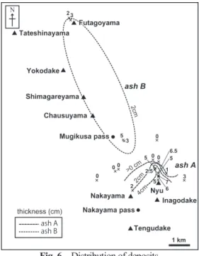
Abstract This study involved a geological survey in the northern Yatsugatake area, central Japan, with the aim of identifying historic eruptive activity of the Yatsugatake volcano. White-colored thin deposits were noted in soil; because of their distribution pattern and particle components, these were determined to be volcanic ash deposits (“ash A” and “ash B”). Their AMS ages are the 14th and 9th centuries, respectively, with the deposit sources estimated to be located around Inagodake and north of the Mugikusa pass, respectively. It is assumed that a few magmatic eruptions of the Yatsugatake volcano occurred within the historical time period. The trigger of AD 887 sector collapse could not be identified in this study.
Key words: Yatsugatake volcano, volcanic ash,AMS, historical eruption, Inagodake
1. Introduction
The frequency of volcanic eruptions generally increases when lower volumes of material are erupted (e.g. McCelland et al. 1989; De la Cruz-Reyna 1991). It is therefore important to gather basic data about small-scale eruptions for reconstructing eruptive histories to estimate the timing of future eruptions. Immediately after large-scale explosive eruptions, erupted materials are usually packed into the soil and stored. On the other hand, it is difficult for products derived from small-scale eruptions to be stored because these are generally thin and/or fine.
The Yatsugatake volcano, located in central Japan, has been active for more than one million years, with effects on its surrounding area. The volcano is voluminous, and a number of studies have addressed in detail the ages and stratigraphies of its eruptive products (e.g. Matsumoto et al.
1999; Uchiyama 2001; Nishiki et al. 2007). However, there are relatively few works focusing on younger eruptive products, such as those from the Late Pleistocene to Holocene. In particular, there has been little study of historical eruptions.
The aim of this study is to describe deposits distributed in the northern Yatsugatake area in order to determine the ages and eruptive characteristics of historical eruptions. The ages of eruptive products were determined using AMS dating. Based on the results obtained, the deposits (characterized as volcanic ash products) will be described. The findings suggest that there may have been a number of historical eruptions in the middle to northern Yatsugatake area.
______________________________________________________________________________
* Department of Geography, Rissho University.
2. Yatsugatake Volcano
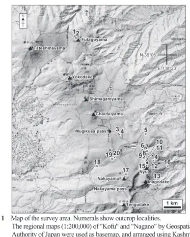
Fig. 1 Map of the survey area. Numerals show outcrop localities.
The regional maps (1:200,000) of "Kofu" and "Nagano" by Geospatial Information Authority of Japan were used as basemap, and arranged using Kashmir 3D.
The Yatsugatake volcano is located on the volcanic front and forms a volcanic chain trending ca. 21 km N–S, with many eruptive centers (Fig. 1). The volcanic chain is usually divided into the
“northern Yatsugatake” and “southern Yatsugatake” at the Natsuzawa pass. The volcanic landforms in the southern Yatsugatake are sharp and poorly vegetated, while the northern Yatsugatake landforms consist of many lava domes, with moderate coverage of conifer forest.
Eruptive activity in and around Yatsugatake area started ca. 1.2 Ma, as the activities of the
Yabashira, Kurumayama, and Kirigamine volcanoes at the base of Yatsugatake. The activity of the
Yatsugatake volcano dates back to ca. 0.5 Ma (Nishiki et al. 2007). The Yokodake lava dome in
the northernmost part of Yatsugatake consists of nine lava flows and one pumice fall deposit and is
recognized as an active volcano; there are some volcanic ash deposits (NYk-1 and NYk-2) and the
eruption age of NYk-1 is estimated to be between 800–600 years ago (Japan Meteorological
Agency 2013). However, Okuno and Kobayashi (2010) doubted the existence of an eruption
corresponded to the NYk-1 tephra bed, considering NYk-2 tephra bed (2.35–2.15 cal ka BP) to be
the most recent products of the Yokodake volcano. Oishi (2015) concluded that the four lava flows
covering the Yt-Pm4 tephra bed (31 cal ka BP) were erupted during the last 31 ky. A sector
collapse occurred in the vicinity of Nyu, Inagodake, Nakayama Pass, and the Tengudake area in
AD 887 or AD 888, and Otsukigawa debris avalanche flew the east flank. Eruptive activity could
have occurred during this event and we therefore must discuss triggers of the sector collapse to determine Holocene volcanic activity.
3. Description
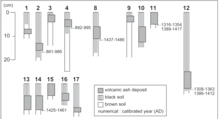
White-colored thin deposits, consisting mainly of silt-sized particles, can be identified from the region between Nyu and the Mugikusa pass of the northern Yatsugatake area (Fig. 2, Table 1).
For purposes of this study, the deposits were washed using water and an ultrasonic cleaner, dried using a hotplate, and sieved (using meshes of 500–250 μm in diameter). Proportions were measured by counting 300 particles.
Fig. 2 Columnar sections showing the stratigraphic positions of the deposits.
Table 1 Sample list
Loc. Thickness Size of
particles * Particle
proportion analysis AMS analysis
1 2 Sa
2 3 Sa ○ ○
3 5 Si ○
4 3 Si ○ ○
5 0 - - -
6 0 - - -
7 0 - - -
8 5 Si ○ ○
9 2.5 Si ○
10 6.5 Si
11 5 Si ○
12 7 Sa ○ ○
13 6 Si
14 1 Si ○ ○
15 5 Si
16 3 Si
17 2 Si
18 0 - - -
19 0 - - -
20 0 - - -
* Sa: sandy, Si: silty
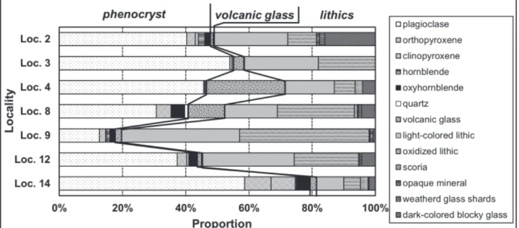
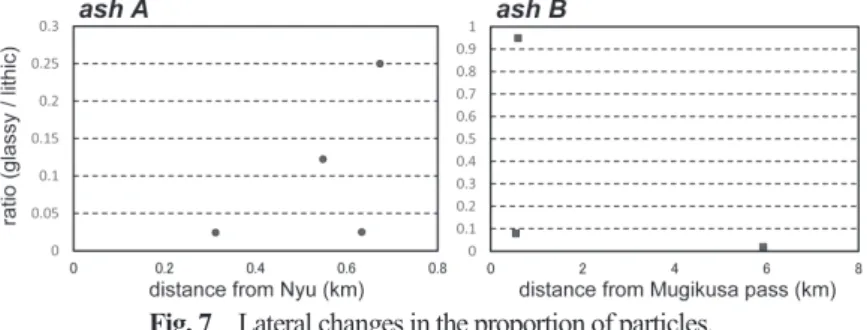
A white-colored deposit, consisting mainly of sandy and silt-sized particles was identified at Loc. 12, slightly north of Nyu. The layer is 7 cm in thickness and is covered by black soil of ca. 25 cm in thickness (Fig. 2). The particles consist of plagioclase, two-pyroxene, and oxyhornblende phenocrysts, light gray lithic fragments, red oxidized lithic fragments, and minor glassy particles (Fig. 3). The glassy particles consists mainly of brown-colored blocky type (Fig. 4). At Loc. 4, on the east side of Mugikusa pass, there is a white-colored deposit consisting mainly of silt-sized particles. The layer is 3 cm in thickness and is covered by black soil of ca. 3 cm in thickness (Fig.
2). The particles consist of plagioclase phenocrysts, lithic fragments, and 25% glassy particles having sharp morphology (Fig. 3). The glassy particles consists mainly of fiber type (Fig. 4). Loc.
2, on the north peak of Futagoyama, includes a deposit that consists mainly of sandy particles; the layer is 3 cm in thickness and is covered by black soil of ca. 13 cm in thickness (Fig. 2). The particles consist of plagioclase, two-pyroxene, and oxyhornblende phenocrysts, light gray-colored lithic fragments, and minor glassy particles (Fig. 3).
Fig. 3 Particle components of the deposits at several localities.
Fig. 4 SEM-based backscattered electron images of the external morphologies of volcanic glass particles contained in the deposits at Locs. 4 and 12.
The SEM (JEOL JSM-6610LV) at the Geological Survey of Japan, AIST was used.
The refractive indices of oxyhornblende (n 2 ) were measured for the deposits in Locs. 8, 9, and 12 using the Refractive Index Measurements System (RIMS) 2000 (produced by Kyoto Fisson Track Co. Ltd.) at the Tokyo Metropolitan University (Fig. 5). The indices for Locs. 8, 9 and 12 were 1.736–1.749, 1.733–1.743, and 1.737–1.746, respectively.
The ages of deposits were measured using the AMS method (Table 2). The samples used were
of black soil located just under the deposits. AMS radiocarbon analysis was conducted at the Paleo Labo Co. Ltd. The samples were treated using the standard acid-alkali-acid method. Following preparation, these were analyzed using accelerator mass spectrometry (compact AMS of Paleo Labo Co. Ltd.: NEC 1.5SDH). Radiocarbon ages were corrected for isotopic fractionation and calendar years were calculated. A 14 C-half-life of 5568 years (Libby half-life) was used for purposes of age calculation. Calibrations were produced using OxCal 4.2, employing the IntCal 13 atmospheric curve (Bronk Ramsey 2009; Reimer et al. 2013).
The ages (correlated calendar year, 2σ) of deposits at Locs. 2 and 4 (north of Shirakomaike pond) were estimated to be AD 881–986 and AD 892–995, respectively (Table 2). On the other hand, the ages of deposits at Locs. 8, 11, 12, and, 14 (south of Shirakomaike pond) were estimated to be AD 1437–1486, AD 1316–1354 and AD 1389–1417, AD 1308–1363 and AD 1386–1412, and AD 1425–1461, respectively (Table 2).
Fig. 5 Refractive indices of oxyhornblende phenocrysts.
Table 2 Results of AMS dating
2 PLD-19038
(110720-2) -24.65±0.12 1125±20 881 AD (95.4%) 986 AD
4 PLD-19040
(110721-1) -23.49±0.17 1095±20 892 AD (95.4%) 995 AD
8 PLD-16919
(101014-2) -24.14±0.15 415±20 1437 AD (95.4%) 1486 AD
11 PLD-16920
(101014-4) -24.69±0.14 565±20 1316 AD (50.6%) 1354 AD 1389 AD (44.8%) 1417 AD
12 PLD-16921
(101014-5) -23.51±0.16 585±20 1308 AD (66.4%) 1363 AD 1386 AD (29.0%) 1412 AD
14 PLD-16923
(101015-2) -23.99±0.29 445±20 1425 AD (95.4%) 1461 AD
Loc. Labo ID δ
13C Calibrated year ranges (2σ)
(‰)
14