Geology and stratigraphy of forearc basin sediments in Hokkaido, Japan: Cretaceous environmental events
on the north-west Pacific margin
Reishi Takashima
a,) , Fumihisa Kawabe
b, Hiroshi Nishi
a, Kazuyoshi Moriya
c, Ryoji Wani
d, Hisao Ando
eaDepartment of Earth and Planetary Science, Graduate School of Science, Hokkaido University, N10W8, Kita-ku, Sapporo 060-0810, Japan
bInstitute of Natural History, 3-14-24 Takada, Toshima-ku, Tokyo 171-0033, Japan
cDepartment of Earth Science, Graduate School of Social and Cultural Studies, Kyushu University, 4-2-1, Ropponmatsu, Chuo-ku, Fukuoka 810-8560, Japan
dDepartment of Geology, National Science Museum, 3-23-1, Hyakunincho, Shinjuku-ku, Tokyo 169-0073, Japan
eDepartment of Environmental Sciences, Faculty of Science, Ibaraki University, 2-1-1, Bunkyo, Mito 310-8512, Japan Received 13 August 2003; accepted in revised form 3 February 2004
Abstract
Litho-, bio-, and chemostratigraphy of the Cretaceous forearc basin sediments exposed in Hokkaido, northern Japan allow a synthesis of the faunal, sedimentological, and environmental history of the north-west Pacific margin. Although the succession, named the Yezo Group, has yielded an abundant record of mid- to late Cretaceous invertebrates, monotonous lithologies of sandstone and mudstone, showing occasional lateral facies changes, have caused confusion regarding the lithostratigraphic nomenclature. Based on our wide areal mapping of the sequence, and analysis of litho- and biofacies, a new lithostratigraphic scheme for the Yezo Group is proposed. In ascending order, the scheme is as follows: the Soashibetsugawa Formation (Lower Aptian mudstone unit); the Shuparogawa Formation (Lower Aptianelower Upper Albian sandstone-dominant turbidite unit); the Maruyama Formation (lower Upper Albian tuffaceous sandstone unit); the Hikagenosawa Formation (Upper AlbianeMiddle Cenomanian mudstone-dominant unit); the Saku Formation (Middle CenomanianeUpper Turonian sandstone-common turbidite unit); the Kashima Formation (Upper TuronianeLower Campanian mudstone-dominant unit); and the Hakobuchi Formation (Lower CampanianePaleocene shallow-marine sandstone-conglomerate unit). In addition, we designate two further lithostrati- graphic units, the Mikasa Formation (Upper AlbianeTuronian shallow-marine sandstone-dominated unit) and the Haborogawa Formation (Middle TuronianeCampanian shelf mudstone/sandstone unit), which correspond in age to the shallower facies of the Saku and Kashima formations, respectively.
Despite a lack of so-called ‘‘black shales’’, because of siliciclastic dilution, our stratigraphic integration has revealed the horizons of oceanic anoxic events (OAEs) in the Yezo Group. The OAE1a horizon in the Soashibetsugawa Formation is characterized by a lack of foraminifers, macrofossils and bioturbation, and a prominent positive excursion ofd13Corg. A significant hiatus during the late Aptian and early Albian removed the OAE1b horizon. The OAE1c horizon in the Maruyama Formation shows a distinct negative excursion ofd13Corgwith a concomitant high productivity of radiolarians. The OAE1d horizon in the middle part of the Hikagenosawa Formation consists of weakly laminated, pyrite-rich mudstone. Planktonic and calcareous benthic foraminifers are absent, whereas radiolarians are abundant above the OAE1d horizon. The mid-Cenomanian event (MCE) horizon is identified at the top of the Hikagenosawa Formation. Stepwise extinction of calcareous benthic foraminifers and a decrease in radiolarian diversity become apparent above the MCE horizon. In the study area, the OAE2 horizon has been well documented, and is placed in the middle part of the Saku Formation.
Ó2004 Elsevier Ltd. All rights reserved.
Keywords:Cretaceous; Stratigraphy; Yezo Group; OAEs; Pacific; Forearc basin
www.elsevier.com/locate/CretRes
)Corresponding author.
E-mail address:[email protected](R. Takashima).
0195-6671/$ - see front matterÓ2004 Elsevier Ltd. All rights reserved.
doi:10.1016/j.cretres.2004.02.004
1. Introduction
Knowledge of Cretaceous ocean-climate systems provides important information to help understanding a future warm greenhouse world. In particular, the mid- Cretaceous warming around 120e90 Ma, enhanced by a huge production of oceanic crust and plateaus in the Pacific and Indian oceans, brought higher levels of greenhouse gases and high poleward heat transportation (e.g., Larson, 1991a,b). This global warming induced a unique deep-ocean circulation and expansion of anoxic conditions, known as oceanic anoxic events (OAEs) that resulted in large turnovers of marine biota (Leckie et al., 2002). Many palaeontological and geochemical studies of OAEs have been conducted in land sections across the Tethyan region (e.g., Erbacher et al., 1996), on deep-sea cores from the Atlantic (e.g., Bralower et al., 1994; Wilson and Norris, 2001), the Antarctic (e.g.,Bralower et al., 1993), and from equatorial Pacific regions (e.g., Sliter, 1989), whereas there is little infor- mation about Cretaceous environmental events in the North Pacific.
The Cretaceous Yezo Group, exposed in central Hokkaido, northern Japan, was probably deposited at about 35e45(N (Hoshi and Takashima, 1999; Kodama et al., 2002) along a westward subduction margin in the north-eastern Asian continent during the Cretaceous.
This group consists of a 10,000-m-thick forearc sedi- mentary sequence of sandstones and mudstones with subordinate conglomerates. This forearc basin is called the Yezo Basin (Okada, 1983), and it extends from offshore of north Honshu, through Hokkaido, to Sakhalin Island, Russia (Fig. 1). As the rocks contain abundant, well-preserved macro- and microfossils, many biostratigraphic schemes have been established (Matsu- moto, 1942, 1977; Tanaka, 1963; Obata and Futakami, 1975; Futakami, 1982; Taketani, 1982; Maeda, 1986;
Toshimitsu and Maiya, 1986; Motoyama et al., 1991;
Kawabe et al., 1996, 2003; Takashima et al., 1997;
Toshimitsu et al., 1998; Kawabe, 2000; Wani and Hirano, 2000; Moriya and Hirano, 2001; Ando et al., 2001; Nishi et al., 2003). In the last decade, carbon isotope excursions of organic materials have also been reported across the Cenomanian/Turonian boundary (OAE2) and from the upper Lower Aptian (Hasegawa and Saito, 1993; Hasegawa, 1995, 1997; Ando et al., 2002, 2003). Moreover, the thermal structure of the north-western Pacific of the Asian continental margin has recently been investigated, based on oxygen isotopic analyses (Moriya et al., 2003). These studies provide important information of Cretaceous environmental change and faunal turnover related to global events in the mid-latitude north-west Pacific.
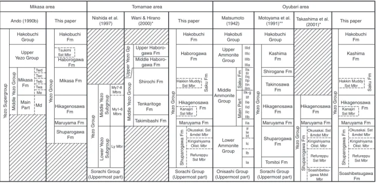
However, the nomenclature of the lithostratigraphic divisions in the Yezo Group are complicated and differ between the areas investigated within Hokkaido, and
several names have been used synonymously for the same lithostratigraphic unit. We, therefore, propose here a new, synthesized stratigraphic framework, in- cluding macro- and microfossil biostratigraphy, based on extensive mapping of the entire area in the central region of Hokkaido. Moreover, we organize the strati- graphic and geographic distribution of OAE horizons recorded in the Yezo Group using the new standard stratigraphy.
2. Geological setting
The Jurassic to Palaeogene sequences exposed in the western and central parts of Hokkaido, northern Japan, are basically divided into three NeS trending tectono- stratigraphic divisions called the Oshima (Cretaceous volcanic arc on a Jurassic accretionary complex), the SorachieYezo (CretaceousePaleocene forearc basin and accretionary complex), and the Hidaka (lower Palaeogene accretionary complex) belts from west to east (Kiminami et al., 1986; Ueda et al., 2000) (Fig. 1).
These were formed along a westward-dipping sub- duction of the IzanagieKula plates under the eastern margin of the Asian continent (e.g.,Okada, 1974).
The SorachieYezo Belt consists of a coherent succession, from the Horokanai Ophiolite through the Sorachi Group to the Yezo Group (Fig. 2), and the accretionary complexes of the Idonnapu and Kamuiko- tan zones (Ueda et al., 2000; Fig. 1). The Horokanai Ophiolite and the lower part of the Sorachi Group represent a piece of basaltic oceanic crust (Ishizuka, 1981; Takashima et al., 2002a), while the upper part of the Sorachi Group is represented by subaqueous calc- alkaline and alkaline volcano-sedimentary sequences, suggesting an oceanic island arc setting (Girard et al., 1991; Niida, 1992; Takashima et al., 2002b). The Yezo Group conformably overlies the Sorachi Group and comprises very thick sandstone and mudstone sequen- ces. The sand clastics of this sequence were derived from Cretaceous granitic rocks and Jurassic accretionary complexes of the Oshima Belt, which represents a contemporaneous continental arc setting (Kito et al., 1986). Although a part of the Hakobuchi Formation includes the upper Paleocene in the Oyubari and Nakatonbetsu areas (Ando et al., 2001; Ando, 2003), the geological age of this formation ranges mostly from early Aptian to early Maastrichtian. Many hiatuses exist between the Campanian and Maastrichtian. The sedi- mentary environment of this group shows an eastward- deepening facies trend, from fluvial to continental slope (Fig. 2). The Yezo Group is unconformably capped by late Eocene, non-marine and shallow-marine sediments of the Ishikari and Poronai groups, or by younger Neogene deposits.
JAPAN SEA
PA CIFIC OCEAN
PACIFIC OCEAN OKHOTSK SEA Sorachi-Yezo
Belt
Hidaka Belt Oshima Belt
Ha yac
hine Tectonic Zone
Hizume- Kesenn
uma Fa
ult
South Kitakami
Belt
42 N 42 N
44 N
140 E 142 E 144 E
20°N 25°
30°
35°
40°
45°
50°
120°E 125° 130° 135° 140° 145° 150°
1000 km 500 0
Legend
Cretaceous-Paleocene forearc basin sediments
Upper Jurassic to Lower Cretaceous volcano-sedimentary successions Cretaceous volcano-sedimentary successions
Cretaceous granitic rocks
High-pressure-type metamorphic rocks Ultramafic rocks
Jurassic accretionary complexes Upper Cretaceous to Eocene accretionary complexes Palaeozoic to Lower Cretaceous shelf to continental sediments
Tomamae area (Fig. 5)
Teshionaka- gawa area
Oyubari & Mikasa area (Fig. 4) SAKHALIN ISLAND
Kam
uik
otan Zone
Ido
. Zone
Idonnappu Zone Kam
uik otan Zone
Nakatonbetsu area
Fig. 1. Simple geological map showing the distribution of the Mesozoic formations of north-east Japan and southern Sakhalin. Dashed-lined frames show the study areas (Figs. 4, 5). The central region (Fig. 4) consists of the south-eastern Oyubari area and the north-western Mikasa area.
3. Stratigraphy of the Yezo Group
Lithostratigraphic nomenclature for the Yezo Group is very confused. Various definitions have been proposed, depending on the area and the researchers, because this group basically consists of a monotonous sequence of sandstone and mudstone and their alternating beds, which occasionally exhibit lateral facies changes. The criteria of lithological boundaries have been defined by sandstone intercalations and/or detailed changes of the sandstone/mudstone ratios in alternating beds. However, our study has revealed that the Yezo Group throughout Hokkaido is basically characterized by six alternations of mudstone-dominant units and sandstone-common
units, with intercalations of six distinct stratigraphic key units (Fig. 2, Table 1). The revised lithostratigraphic definitions proposed in this paper are as follows, in as- cending order (Figs. 2, 3): the Soashibetsugawa Forma- tion (mudstone unit); the Shuparogawa Formation (sandstone-dominant turbidite unit); the Maruyama Formation (felsic tuff and tuffaceous sandstone unit);
the Hikagenosawa Formation (mudstone-dominant unit); the Saku Formation (sandstone-common turbidite unit); the Kashima Formation (mudstone unit) and the Hakobuchi Formation (shallow-marine sandstone unit).
We also recognize the sandstone-dominant, outer- shelf to shoreface Mikasa Formation and the overlying,
Soashibetsugawa Fm (<700m)
Jurassic Sorachi
Group
Horokanai Ophiolite Maruyama Fm
(< 500m)
Kirigishiyama Olisto. Mbr Okusakainosawa Sst & Mdst Mbr
Alternating beds of sst (turbidite) & mdst Alternating beds of sst (turbidite) & mdst
Alternating beds of sst (turbidite) & mdst
Intercalations of thick felsic tuff & green sandy mdst
Slump
Alternating beds of sst (turbidite) & mdst
Thick-bedded congl & sst
Alternating beds of sst (turbidite) & mdst
Olistostrome occasionally containing lst olistoliths
Mafic-intermediate volcaniclastics and lava Felsic volcaniclastic sst. (turbidite) and
tuff beds with resedimented congl Weakly laminated and/or bioturbated mdst
Weakly bioturbated mdst
& massive mdst Weakly bioturbated
sandy mdst
Laminated mdst with frequent intercalations of felsic tuff beds
Mafic-ultramafic igneous basement Kanajiri
Sst Mbr Tsukimi Sst Mbr
Hakkin Muddy Sst Mbr
Refureppu Sst Mbr Hikagenosawa Fm
(2600-1900m)
Saku Fm
(2300-1800m)
Haborogawa Fm
(1750-2250m) Kashima Fm (1670m)
Hakobuchi Fm
(<450m)
Geological column Lithostratigraphic units
Lithology
Age Oyubari
area Key beds
Tomamae area Mikasa area
Oyubari area Tomamae
area Mikasa
area
Ishikari / Poronai Group Palaeogene Mikasa Fm (400-750m)Shuparogawa Fm (800-2450m)
AptianBerrias.- Bar.Albian
Cretaceous Yezo Group
CenomanianTuronianConiacianSantonianCampan.- Maastricht. KY-1KY-2KY-3KY-4KY-5KY-6
Strongly bioturbated mdst-sandy mdst
TCS sst
Strongly bioturbated
mdst Felsic volcaniclastic sst (prodelta / turbidite) and tuff
Felsic volcaniclastic sst (turbidite) and tuff Bioturbated sandy slst-sst, congl, HCS-TCS sst
and coaly mdst with felsic tuff
Congl, HCS-TCS sst, bioturbated sandy mdst
Bioturbated muddy sandstone
Sst>mdst Sst<mdst
Sst>mdst Sst<mdst
Sst>mdst Sst>mdst
Sst>mdst
Sst<mdst Sst<mdst
Sst<mdst
Sst<mdst
Sst, coaly mdst and coal
No exposure
Planktonic foraminiferal
zone (Nishi et al.,2003)
Environment
Oceanic island arc
Continental slope Continental slopeContinental slope Incised v
alle y-outer shelf Shelf-coastal plain
Fluvial
Outer-inner shelf Fluvial-inner
shelf
Globigerinelloides spp.
Leupoldina cabri Ticinella primula Biticinella breggiensis
Rotalipora subticinensis Rotalipora ticinensis
R. appenninica
"Barren interval"
Helvetoglobotruncana helvetica Globotruncana arca
Contusotruncana fornicata
Marginotruncana sinuosa
Marginotruncana pseudolinneiana
Rotalipora globotruncanoides
Rotalipora cushmani W. archaeocretacea
Sst>mdst
Sst<mdst
Fig. 2. Schematic diagram of the Yezo Group in the study areas. Note that the geological column shows eastward-deepening facies.
sandy mudstone-dominant outer-shelf Haborogawa Formation. The former is exposed in the Mikasa area, and the latter in the Tomamae and Mikasa areas (Figs. 2, 4, 5). The geological ages of these formations correspond to the Saku and Kashima formations exposed in the Oyubari area, respectively (Fig. 2). Additionally, in the study areas we name six stratigraphic key units as KY-1 to KY-6 consisting of olistostrome (KY-1), tuffaceous sandstone (KY-2, KY-4 to 6), and sandstone-conglom- erate units (KY-3) (Fig. 2,Table 1).
3.1. Soashibetsugawa Formation (redefined)
Definition. This formation is characterized by a pre- dominance of dark grey siliceous mudstone, and cor- responds to the Soashibetsugawa Mudstone Member of the Shuparogawa Formation ofTakashima et al. (2001) (Fig. 3).Takashima et al. (2001)defined the member as the basal unit of the Yezo Group because of the lithofacies shift from in situ volcanic and volcaniclastic rocks of the Sorachi Group to terrigenous, dark grey mudstone at the base of the member. As the member is widely traceable and clearly distinguishable from other members (sandstone-dominant facies) of the Shuparo- gawa Formation ofTakashima et al. (2001), we redefine the member as the basal formation of the Yezo Group.
Stratigraphic relationship. This formation conform- ably overlies the Shirikishimanaigawa Formation of the Sorachi Group.
Type section. The Soashibetsu River section, northern Oyubari area (Figs. 4, 6; section 11).
Lithology. The formation consists of dark grey parallel-laminated mudstone with many intercalations of felsic tuff beds (Fig. 7A). The laminae are composed of felsic tuff and very fine-grained sand layers. Deep-sea trace-fossils, such as Lorenzinia and Cosmorhaphe, are found occasionally in the mudstone. The tuff beds are white, hard and generally 10e30 cm thick, though some beds attain a thickness of 1e7 m. They contain fine- grained, bubble-wall glass shards with minor amounts of idiomorphic feldspar and biotite.
Thickness and distribution. The formation is 450e 700 m thick in the eastern part of the Oyubari area, and not exposed in the Mikasa and Tomamae areas.
Fossils and age. No macrofossils have been found in this formation. Radiolarians occur abundantly through- out the sequence of this formation, but there are no age-diagnostic species. Planktonic foraminifers appear rarely in the upper part (Fig. 8). The early Aptian spe- cies, Leupoldina cabri (Sigal), occurs from the upper- most part of the formation (Saito and Ando, 2000;
Takashima et al., 2001; Nishi et al., 2003). Agglutinated benthic foraminifers, such as Bathysiphon, also occur occasionally.
Depositional environment. Microfossil assemblages and deep-sea trace fossils suggest an abyssal environment.
3.2. Shuparogawa Formation (redefined)
Definition. This formation, corresponding to the Tomitoi and Shuparogawa formations of Motoyama
Table 1
List of the widely traceable key units of the Yezo Group
Key units Thickness Lithofacies Horizons Age Picture
KY-6 10e30 m Tuffaceous coarse
sandstone beds
Middle parts of the Kashima and Haborogawa formations (Tsukimi Sst Mbr)
Latest Santonian Fig. 7N, O
KY-5 10e20 m Greenish tuffaceous
coarse sandstone beds with abundant I. uwajimensis
Lower parts of the Kashima and Haborogawa formations
Early Coniacian Fig. 7M
KY-4 !300 m Greenish gray tuffaceous muddy sandstone with abundant Planolitestrace
fossils and very thick felsic tuff beds
Middle part of the Saku Formation (Hakkin Muddy Sst Mbr)
Early Turonian Fig. 7I
KY-3 100e300 m Sandstone-conglomerate beds
Lower middle part of the Hikagenosawa Formation (Kanajiri Sst Mbr)
Latest Albian Fig. 7G
KY-2 !82 m Felsic tuff and tuffaceous sandstone beds
Maruyama Formation Early Late Albian Fig. 7E KY-1 !400 m Olistostrome or debris flow
deposits occasionally containing
‘‘Orbitolina’’ limestone blocks
Middle part of the Shuparogawa Formation (Kirigishi. Olistostrome Mbr)
Late Aptiane Early Albian
Fig. 7C
et al. (1991), is distinguished from the mudstone- dominant Soashibetsugawa Formation by the onset of common to frequent intercalations of sandstone beds.
Type section. Along the Shuparo River section, the central Oyubari area (Figs. 4, 6; section 12).
Stratigraphic relationships. The Shuparogawa For- mation conformably overlies the Soashibetsugawa Formation in the Oyubari area, while the basal part of this formation is not exposed in the Tomamae and Mikasa areas because of poor exposure.
Lithology. The Shuparogawa Formation is mainly composed of alternating beds of turbiditic sandstone and dark grey mudstone. This formation incorporates a thick olistostrome bed (Kirigishiyama Olistostrome Member) in the middle portion, and is subdivided into three members as follows: the Refureppu Sand- stone, Kirigishiyama Olistostrome, and Okusakaino- sawa Sandstone and Mudstone members, in ascending order (Figs. 2, 6).
The Refureppu Sandstone Member consists of a very thick- to medium-bedded, sandstone-dominant sequence in the lower part (Fig. 7B) and thin to very thin-bedded, mudstone-dominant alternating beds in the upper part.
It contains slump beds locally. Lower sandstones are stratified, well sorted, usually ranging from 10 to 50 cm thick, and occasionally more than 1 m thick. They are turbidites showing the S3eTb-edivisions ofLowe (1982), with many sole marks. The sandstone/mudstone (S/M)
ratio in the lower part is about 5/1. Sandstones in the upper part are less than 5 cm thick, with Tc-edivisions, and the S/M ratio is 1/2 to 1/5. Mudstones in this member are uniformly less than 10 cm thick, dark grey and weakly bioturbated. In the northern Oyubari area, this member is dominated by sandstone throughout (Fig. 6; section 11).
The Kirigishiyama Olistostrome Member represents an olistostrome bed containing huge allochthonous blocks of massive sandstone (!40 m thick), alternating beds of sandstone and mudstone (!20 m thick) and limestone (!60 m thick) in a muddy matrix (Fig. 7C).
Limestone olistoliths consist of corals, large foraminifers (Orbitolina), rudists and ooids, contaminated with pebbles of chert, granite and sandstone. The width and thickness of limestone olistoliths is greatest in the northern Oyubari area where a 60-m-thick, slab-shaped block is continuously exposed for a distance of 3 km in a NeS direction (Fig. 4, around Mt. Kirigishiyama). The limestone olistoliths thin out in the Tomamae and southern Oyubari areas. However, the olistostrome bed is widely traceable throughout the study area as a key unit (KY-1) (Fig. 6).
The Okusakainosawa Sandstone and Mudstone Member basically comprises mudstone-dominant alter- nating beds, and varying thicknesses of sandstone, from 5 to 50 cm depending on the area (Fig. 7D). Sandstones are turbiditic, exhibiting Tb-esequences with sole marks and numerous plant fragments, while thick sandstones show the S1-3divisions of Lowe (1982). In the Oyubari area, intercalations of sandstone become common to
Oyubari area Tomamae area
Mikasa area
Motoyama et al.
(1991)**
Matsumoto (1942) Wani & Hirano
(2000)*
Nishida et al.
(1997)
Shuparogawa Fm
Tomitoi Fm Maruyama Fm Hikagenosawa
Fm Takinosawa
Fm Shirogane Fm
Kashima Fm
Yezo Group
Upper Ammonite
Group
IIa IIm IIn IIp IIqIIr IIs IIIa IIIb IIIc IIId
IIb IIc IId IIe IIf
Ia Ib Ic Id IeIf IIk-g Middle Ammonite
Group
Saku FmMain Part
Lower Ammonite
Group
Hakobuchi Group Hakobuti
Group Hakobuchi
Group
Sorachi Group (Uppermost part) Onisashi Group
(Uppermost part) Sorachi Group
(Uppermost part) Lower Yezo SubgroupMiddle Yezo Subgroup
This paper Takashima et al.
(2001)*
Ando (1990b)
Shuparogawa Fm
Soashibetsugawa Fm Maruyama Fm
Okusakai. Sst
&mdst Mbr Okusakai. Sst
&mdst Mbr
Kanajiri Sst Mbr Hakkin Muddy
Sst Mbr
Kirigishiyama Olist. Mbr Kirigishiyama
Olist. Mbr
Refureppu Sst Mbr Soashibetsu-
gawa Mdst Mbr Refureppu
Sst Mbr
Hikagenosawa Fm
Saku Fm
Kashima Fm
Yezo Group
Hakobuchi Fm
Shuparogawa Fm
Maruyama Fm Hikagenosawa
Fm
Yezo Group
Yezo Group
Tenkaritoge Fm Takimibashi Fm
Shirochi Fm Upper Haboro-
gawa Fm Middle Haboro-
gawa Fm Upper Yezo GpMiddle Yezo Group
This paper
Shuparogawa Fm
Ly Mbr My7-8 Mbrs
My1-6 Mbrs Maruyama Fm
Hikagenosawa Fm Mikasa Fm Haborogawa
Fm
Yezo Group
Yezo Supergroup
Hakobuchi Fm
Mikasa Fm
Middle Yezo Group
Upper Yezo Group
Main Part Md
Me Twa Twb Twc Twd
This paper
Shuparogawa Fm
Sorachi Group (Uppermost part)
Maruyama Fm Okusakai. Sst
&mdst Mbr Kanajiri Sst Mbr Hakkin Muddy
Sst Mbr
Kirigishiyama Olist. Mbr Refureppu Sst Mbr Hikagenosawa
Fm
Saku Fm
Haborogawa Fm
Yezo Group
Hakobuchi Fm Tsukimi
Sst Mbr
* Same definition is used in Nishi et al. (2003)
* *Same definition is used in Hasegawa & Saito (1993), Kaiho et al. (1993), Kaiho & Hasegawa (1994), Hasegawa (1995) and Hasegawa (1997)
Fig. 3. Comparison of lithostratigraphic subdivisions proposed by several workers in the study areas.
abundant in the middle part of this member (Fig. 6;
section 11). Mudstones are bioturbated with moderate numbers of trace fossils.
Thickness. The formation is approximately 1500 m thick in the type section. However, it varies in thick- nesses, ranging from 800 to 2450 m.
Fossils and age. Mudstones of the Refureppu Sand- stone Member yield a few foraminifers and common radiolarians, but no macrofossils (Fig. 8). Planktonic foraminifers include the Upper Aptian species,Globiger- inelloides barri (Bolli, Loeblich and Tappan) and G.
duboisi(Chevalier). Agglutinated and calcareous benthic foraminifers also occur occasionally. The Okusakaino- sawa Sandstone and Mudstone Member contains abun- dant radiolarians and planktonic foraminifers, with a subordinate proportion of common agglutinated and calcareous benthic foraminifers. The Upper Albian ammonoid,Mortonicerascf.geometricumSpath, occurs in the upper part of this member (Kawabe, 2000). This member also includes the transitional interval from the Ticinella primula planktonic foraminifera (pf) Zone to the lower part of the Biticinella breggiensis pf Zone, assigned to the Lowerelower Upper Albian (Nishi et al.
2003) (Fig. 8). A significant hiatus is present from thePlanomalina cheniourensisto Hedbergella planispira zones ofHardenbol et al. (1998), approximately 115.5e 108.21 Ma (7 myr). It might have been eroded during deposition of the Kirigishiyama Olistostrome Member.
The limestone olistoliths yield larger foraminifers of orbitolinids, e.g., Orbitolina lenticularis (Blumenbach), and its age is determined as Late AptianeEarly Albian (Matsumaru, 1971).
Depositional environment. Lithology and benthic foraminiferal data suggest that this formation was deposited on the continental slope (e.g., Motoyama et al., 1991). Benthic foraminifers of the Refureppu Sandstone Member and the Okusakainosawa Sandstone and Mudstone Member, consisting of species ofBathy- siphon,Gaudryina,Gyroidinoides,GavelinellaandNodo- saria, indicate the upper bathyal zone or deeper (e.g., Sliter and Baker, 1972). However, the limestones of the Kirigishiyama Olistostrome Member are considered to have been formed on a carbonate platform, such as a rimmed shelf along the Asian continental margin (Sano, 1995). The olistostrome indicates the collapse of the shallow carbonate platform and mixing with the bathyal mudstone around the Aptian/Albian boundary.
3.3. Maruyama Formation
Definition. This formation is defined by an assem- blage of hard felsic volcaniclastic sandstones, tuffs and associated conglomerates (Motoyama et al., 1991) (Fig. 3). It also yields an excellent stratigraphic marker (KY-2), which extends throughout Hokkaido (Table 1).
Type section. Along the Shuparo River section, cen- tral Oyubari area (Figs. 4, 6; section 12).
Stratigraphic relationship. This formation conform- ably overlies the Shuparogawa Formation.
Lithology. This formation is composed of tuffaceous sandstone beds (Fig. 7E), locally accompanied by conglomerates at the base. The tuffaceous sandstone beds are 0.3e2 m thick, white to pale brown, siliceous and very hard. These beds have turbiditic features of graded to parallel-laminated sequences (Tb-e) and basal rip-up mudstone clasts. Microscopically, the sandstones are composed of platy glass shards, subordinate idio- morphic plagioclase, biotite, quartz and hornblende. The tuffaceous unit varies from 4 to 84 m thick throughout the study area.
The conglomerates accompanying the base of this formation are usually less than 2 m thick. However, in the central part of the Tomamae area (Fig. 5), the total thickness of the conglomeratic beds exceptionally attains as much as 900 m (Fig. 6; section 10). The conglomerates are thick-bedded, poorly sorted, and clast-supported, structureless or exhibiting R3eS1 divisions of Lowe (1982). The conglomerates consist mainly of subrounded pebbleseboulders of rhyolite, with subordinate, well- rounded granules to pebbles of mudstone, chert and siliceous mudstone in the Tomamae area, whereas in the Oyubari area they are composed of granules to pebbles of chert, sandstone, siliceous mudstone and limestone.
Thickness. This formation attains thicknesses of 180e900 m in the Tomamae area and 4e84 m in the Oyubari area. The horizon and thickness of this for- mation are disputable in the Mikasa area because of poor exposure.
Fossils and age. Although no planktonic foraminifers and macrofossils have been obtained from this forma- tion, radiolarians (spumellarians) occur abundantly (Fig. 8).
Fig. 4. Geological map and structural profile section of the Oyubari and Mikasa areas, central Hokkaido Island region. The south-eastern Oyubari and north-western Mikasa areas are bounded by the Katsurazawa Thrust Fault. Although most areas in this map are based on our original data, the southern Mikasa area (the Manji and Hatonosu domes) and northeastern Oyubari area (around the Mt. Yubaeyama) are modified fromTanaka (1970), Obata and Futakami (1975), Futakami (1982) and Hashimoto (1953), respectively.
Fig. 5. Geological map and structural profile section of the Tomamae area; seeFig. 4for legend.
Depositional environment. Abundant volcaniclastic materials in this formation suggest that huge, felsic volcanic eruptions episodically occurred along the western circum-Pacific/Asian continental margin. Main transporting channels for the volcanic sediments are inferred to have been located in the Tomamae area.
3.4. Hikagenosawa Formation
Definition. This formation is defined by the pre- dominance of dark grey mudstone (Motoyama et al., 1991;Fig. 3), although there are intercalations of a thin sandstone-dominant unit (Kanajiri Sandstone Member) in the lower middle part.
Type section. Along the Hikageno-sawa Valley sec- tion, the central Oyubari area (Fig. 4).
Stratigraphic relationship. The formation overlies, conformably, the Maruyama Formation.
Lithology. The dominant lithology of the Hikageno- sawa Formation is dark grey mudstone (Figs. 6, 7F). A thin unit of alternating beds of sandstone/conglomerate and mudstone (Kanajiri Sandstone Member) is in- tercalated in the lower middle part of this formation.
This unit is used as a stratigraphic marker, the KY-3 (Fig. 2,Table 1).
The lower part of this formation is characterized by weakly-laminated mudstone. The intercalations of thin- bedded felsic tuffs and distal turbiditic sandstones showing Tc-e divisions are common in the Tomamae and Mikasa areas. In the northern Tomamae area, thick- to very thick-bedded sandstones with S3eTb-eare, exceptionally, also intercalated (Fig. 6; section 9). On the other hand, rare sandstones are intercalated in the Oyubari area. Mudstones in the upper part of this formation are moderately bioturbated, and occasionally weakly laminated.
The Kanajiri Sandstone Member is composed of thick- to very thick-bedded sandstone with very thick- bedded conglomerates in the Tomamae area, whereas in the Oyubari area it comprises thin- to medium-bedded, mudstone-dominant alternating beds of sandstone and mudstone (Fig. 7G). Sandstones are proximal (S3eTb-e) in the former area and distal (Td-e) in the latter. The conglomerates are well-rounded pebbles to granules, exhibiting R3eS1 divisions. Their compositions are mostly chert with minor sandstone, mudstone and
igneous rocks. The horizon and thickness of this member are disputable in the Mikasa area because of poor exposure and scarce fossil data.
Thickness and distribution. 1900e2600 m thick in the Oyubari area, and 1900e2000 m thick in the Tomamae area. The thickness in the Mikasa area is uncertain because of poor exposure.
Fossils and age. The occurrence of macrofossils (ammonoids and inoceramids) becomes common above the lower part of this formation (Fig. 8). The late Albianemiddle Cenomanian ammonoids Mortoniceras rostratum (Sowerby), Mariella bergeri (Brongniart), Mantelliceras saxbii (Sharpe) and Cunningtoniceras cunningtoni (Sharpe) occur in the formation. Micro- fossils are abundant throughout the sequence. Excep- tionally, planktonic foraminifers and calcareous benthic foraminifers are lacking around the Kanajiri Sandstone Member, whereas radiolarians become very abundant and agglutinated benthic foraminifers are common in this interval (Fig. 8). Planktonic foraminifers indicative of the Biticinella breggiensis to Rotalipora cushmani pf zones, for example, Biticinella breggiensis (Gandolfi), Ticinella subticinensis(Gandolfi),Rotalipora appenninica (Renz), R. globotruncanoides Sigal, and R. cushmani (Morrow), occur, indicating a Late AlbianeLate Cen- omanian age (Nishi et al., 2003; Fig. 8).
Depositional environment. Benthic foraminiferal as- semblages suggest that this formation was deposited in the lower part of the upper bathyal zone under relatively oxygenated conditions (Motoyama et al., 1991; Kaiho et al., 1993).
3.5. Saku Formation
Definition. This formation is defined by the frequent intercalations of turbiditic sandstone beds (Matsumoto, 1942).
Type section. The Abeshinai River section, Teshio- nakagawa area, northern Hokkaido (Fig. 1). The lithology and distribution of this formation were well documented byMatsumoto (1942)and Matsumoto and Okada (1973).
Stratigraphic relationship. The formation overlies con- formably the Hikagenosawa Formation.
Fig. 6. Correlation of selected sections from the study areas. 1e5, Mikasa area. 1, Shikoro-zawa Valley; 2, Ponbetsu River; 3, Yonno-sawa Valley; 4, Ganseki-zawa ValleyeNanashi-zawa Valley; 5, Tsukimi-sawa Valley. 6e10, Tomamae area. 6, Sankebetsu River; 7, Nakafutamata River; 8, Shumarinai River; 9, Sounnai RivereKotanbetsu River; 10, Gosen RivereKanajiri-zawa ValleyeAkanosawa Valley. 11e17, Oyubari area. 11, Soashibetsu River; 12, Shuparo River; 13, Tengu-sawa Valley; 14, Hakkin-zawa Valley; 15, Oyubari dam; 16, Horokakuruki River; 17, Mayachi- zawa Valley. Each section is cited inFigs. 4 and 5. Note that the precise thicknesses of the KY2 (sections 11e13) and KY-5,6 could not be depicted because of scale problems; seeTable 1for these.
Lithology. This formation comprises alternating beds of turbiditic sandstone and mudstone, and intercalates with a unit characterized by a predominance of greenish grey muddy sandstones (Hakkin Muddy Sandstone Member; KY-4) in the middle part (Fig. 2,Table 1).
Sandstones in the lower part (below the KY-4) are less than 40 cm thick and exhibit typical turbiditic sequences, having Tb-e divisions. Mudstones are dark grey-coloured and moderately bioturbated. The S/M ratios change from 1/10 to 1/1 (Fig. 7H).
A very characteristic lithofacies, greenish grey muddy sandstone with abundant trace fossils of Planolites (Fig. 7I), is observable in the middle part of this formation. This greenish unit extends from the Oyubari area to the central Tomamae area, about 200 km, and is defined as the KY-4 (Hakkin Muddy Sandstone Member). The member incorporates medium-/thick- bedded sandstones, with S3eTb-edivisions, and frequent felsic tuff beds. The tuff beds vary in thickness from 0.02 to 2 m, and are altered to bentonites. Finely laminated, pyrite-rich, dark greyegreyish black mudstones are intercalated just below or in the lower part of this member in the Oyubari and Tomamae areas.
The upper part of the formation begins with dark grey mudstone and changes to alternating beds of sandstone and mudstone. Sandstones are thin- to medium-bedded turbidites with Tb-esequences, and the S/M ratios are not high, 1/10 to 1/5. Slump beds and sandstone dykes are common in the southern Oyubari area. Sandstones are occasionally intensively biotur- bated and bedding planes of some beds are destroyed.
Mudstones and sandy mudstones are dark grey to grey and intensively bioturbated.
On the other hand, the Saku Formation, exposed in the northern Tomamae area, is marked by four thinning-upward sequences (Fig. 6; section 8). A channel- filling conglomerate/sandstone unit constitutes the first and third sequences. The conglomerates are clast- supported, and 0.5e4 m thick, with disorganized erosional bases (Fig. 7J). Graded bedding, from well-rounded cob- ble to coarse sandstone (R2-3eS1divisions), is common.
The sandstones are very thick-/thick-bedded, showing S1eTb-edivisions. The second and fourth cycles show the facies changes from very thick-/thick-bedded, sandstone- dominant alternating beds to thin-bedded mudstone- dominant ones. The sandstones are proximal turbidites, exhibiting S1eTb-edivisions.
Thickness and distribution. 2300 m in the Oyubari area, 1800e2000 m in the Tomamae area. The upper part of this formation is truncated by the NeS trending thrust fault (Kashima Thrust Fault) in the northern Oyubari area (Fig. 4).
Fossils and age. Except for the Hakkin Muddy Sandstone Member the formation contains abundant macrofossils (Fig. 8). The Cenomanian ammonoids, Calycoceras spp., occur in the lower part of the for- mation. The blackish-grey mudstone intercalated in the basal part of the Hakkin Muddy Sandstone Member is correlated with the Cenomanian/Turonian boundary, based on the results of carbon isotope, mega- and microfossil stratigraphy (e.g., Hasegawa and Saito, 1993; Hirano, 1995). Although macrofossils are few in the Hakkin Muddy Sandstone Member, Lower Turo- nian indicators, such as Pseudaspidoceras flexuosus (Powell) and vascoceratids, occur. The upper sequence is marked by an abundant occurrence of heteromorphic ammonoids, includingNipponites,Eubostrichocerasand scaphitids, with minor Middle Turonian indicators, such as Romaniceras spp. (ammonoid) and Inoceramus hobetsensis Nagao and Matsumoto (bivalve). Micro- fossils commonly occur throughout the sequence; radio- larians are especially abundant in the Hakkin Muddy Sandstone Member, and occupy 80e90% of the total.
This formation ranges from the Rotalipora cushmanito Helvetoglobotruncana helveticapf zones, assigned to the Upper CenomanianeMiddle Turonian (Nishi et al., 2003;Fig. 8).
Depositional environment. The benthic foraminif- eral assemblages indicate the lower part of upper
Fig. 7. Photographs of the representative lithofacies of the Yezo Group. A, laminated mudstone with frequent intercalations of felsic tuff beds;
Soashibetsugawa Formation, Soashibetsu River, northern Oyubari area. B, sandstone-dominant alternating beds of sandstone and mudstone;
Shuparogawa Formation, Refureppu Sandstone Member, Soashibetsu River, northern Oyubari area. C, olistostrome containing large limestone blocks; Shuparogawa Formation, Kirigishiyama Olistostrome Member (KY-1), Okusakaino-sawa Valley, central Oyubari area. D, alternating beds of sandstone and mudstone; Okusakainosawa Sandstone and Mudstone Member, Shuparo River, central Oyubari area. E, felsic tuffaceous sandstones; Maruyama Formation (KY-2), Uenbetsu River, southern Tomamae area. F, weakly laminated mudstone; Hikagenosawa Formation, Tengu-sawa Valley, central Oyubari area. G, mudstone-dominant alternating beds of sandstone and mudstone; Hikagenosawa Formation, Kanajiri Sandstone Member (KY-3), Shuparo River, central Oyubari area. H, alternating beds of sandstone and mudstone; Saku Formation, Shumarinai River, northern Tomamae area. I, greenish grey muddy sandstone with abundantPlanolites(KY-4), Saku Formation, KY-4, Hakkin-zawa Valley, southern Oyubari area. J, conglomerate bed with erosional base; Saku Formation, Shumarinai River, northern Tomamae area. K, sandstone with hummocky cross-stratification; Mikasa Formation, western Katsura-zawa Lake, southern Mikasa area. L, massive mudstone; Kashima Formation, Horokakuruki River, southern Oyubari area. M,Inoceramus uwajimensisshell bed (KY-5), Kashima Formation, Okusamata-zawa Valley, central Oyubari area. N, felsic volcaniclastic sandstone; Haborogawa Formation, Tsukimi Sandstone Member (KY-6), Ashibetsu River, eastern Mikasa area. O, coarsening upward sequences, from sandy mudstone to medium-grained sandstone; Haborogawa Formation, Nakanofutamata River, northern Tomamae area. P, sandstone with hummocky cross-stratification; Hakobuchi Formation, Hachigatsu-zawa Valley, eastern Mikasa area.
bathyal depth-zone with relatively low-oxygen condi- tions (Kaiho et al., 1993).
3.6. Mikasa Formation
Definition. This formation is the contemporaneous, shallower facies of the Saku Formation, and is defined by the predominance of sandstones exhibiting hum- mocky and trough cross-stratification (Matsumoto, 1951; Ando, 1990a).
Type section. North-west of Katsurazawa Lake, in the eastern Mikasa area (Fig. 4).
Lithology. The Mikasa Formation is characterized by a predominance of sandstones with hummocky and trough cross-stratification (HCS and TCS) and gravel/
shell lags, and intensively bioturbated sandy mudstone (Fig. 7K). It is divided into three coarsening-upward successions, assigned as third-order depositional sequen- ces (DS1, DS2and DS3), each of which further includes three fourth-order sequences (4th DS) (Ando, 1997),
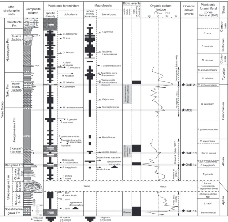
Fig. 8. Composite column of the Yezo Group, summarized lithology, macro-, microfossil and carbon isotope stratigraphy and microfossil biotic events. Note that five OAE horizons are identified within the Yezo Group.
Within each DS, conglomerate and coarse-grained sand- stone tend to thicken in the west, and interbedded sandy mudstone becomes dominant and thick in the east.
In the northwestern Mikasa area, the DS1begins with alternating beds of turbiditic sandstone and mudstone, and grades into HCS sandstone with bioturbated, very fine-grained sandstone/sandy mudstone. A basal thick, cross-stratified conglomerate of the DS2 covers HCS sandstones of DS1 with a sharp erosional base (un- conformity) (Fig. 6; section 2). The DS2 comprises a wide variety of lithofacies, such as cross-stratified conglomerate, carbonaceous mudstone, sandy mud- stone with oyster-shell beds, medium- to coarse-grained sandstone with TCS, HCS fine sandstone and biotur- bated sandy mudstone. The DS3deposits are distributed in the southern Mikasa area, mainly comprising bio- turbated, sandy mudstone and HCS sandstones. The intercalations of HCS sandstone become frequent in the upper part of each fourth DS. These DSs grade into the Saku Formation northward and eastward.
Thickness and distribution. This formation is exposed only in the Mikasa area, forming the SorachieIkush- umbetsu Anticline and the Manji and Hatonosu domes.
Its thickness ranges from 400 to 750 m, and it tends to thicken eastward.
Fossils and age. Shallow-marine bivalves (including Apiotrigonia, Glycymeris, Meekia, Pinna, Pseudoptera, Pterotorigonia, Thetis, Yaadia), gastropods (e.g., Mar- garites,Semisolarium) occur as storm-lag deposits within HCS sandstones. Bioturbated, muddy sandstones to sandy mudstones contain rare to common ammonoids and inoceramids, but no microfossils. The Cenomanian ammonoids, Mantelliceras sp., Calycoceras sp. and Desmoceras spp. have been reported from the DS1
deposits (Kawabe, 2003). The Turonian species,Inocer- amus hobetsensis and Inoceramus teshioensis Nagao and Matsumoto, are abundant in bioturbated sandy mudstones of DS2 and DS3, respectively (Ando, 1990a,b).
Depositional environment. Three DSs show conspicu- ous lateral and vertical facies changes, representing repetitive delta progradations in the western margin of the Yezo Basin. Judging from the stacking patterns of their facies, third- and fourth-order DSs, the delta system is presumed to have shifted southward within the distribution area (Ando, 1997, 2003). The depositional environment of the DS1deposits is interpreted as basin- plain on continental slope to lower shoreface through shelf. The DS2represents non-marine to shallow-marine environments, such as fluvial channel, back marsh, flood plain and tidal flat in the lower part, followed by deeper marine (shoreface to inner shelf, though partly outer shelf) in the upper. The DS3is thought to have
been deposited in lower shoreface to outer shelf environments.
3.7. Kashima Formation
Definition. The formation is defined by the pre- dominance of dark grey, massive mudstone overlying the Saku Formation (Motoyama et al., 1991;Fig. 3).
Type section. Kashima village in the southern Oyubari area (Fig. 4).
Stratigraphic relationship. This formation covers, con- formably, the Saku Formation.
Lithology. This formation consists mainly of dark grey, bioturbated, massive mudstone (Fig. 7L), grading into muddy sandstones in the uppermost part. The mudstones are intercalated with two felsic volcaniclastic units, in the lower and middle parts, respectively. The lower volcaniclastic unit is 10e20 m thick, consisting of thick-bedded, coarse- to fine-grained, volcaniclastic sandstones with interbedded dark grey mudstones. The sandstone beds are turbiditic with Tb-edivisions, and less than 2 m thick, rarely attaining 4 m thick in the northern Oyubari area. The thickness of the mudstones is variable, depending on the area, but all are less than 2 m thick. A diagnostic feature of this unit is abundant occurrences ofInoceramus uwajimensisYehara from the interbedded mudstone (Fig. 7M). This unit is an ex- cellent stratigraphic marker (KY-5) throughout the study areas (Table 1).
Compared with the lower unit, the upper volcani- clastic unit differs in lacking mudstone intercalations and macrofossils. Tuffaceous sandstones or tuffs are thick-bedded (!1 m thick), white, coarse- to very fine- grained. Some are altered to bentonite.
Thickness. About 1670 m in the southern Oyubari area. The thickness of this formation in the northern Oyubari area is difficult to estimate because of the monotonous lithology and complex geological structure, with isoclinal folding and thrust faulting.
Fossils and age. This formation contains abundant calcareous concretions, including macrofossils such as ammonoids and inoceramids. I. uwajimensisis particu- larly abundant in the KY-5 unit (Fig. 8).
Microfossils (foraminifers and radiolarians) are abundant, although Tethyan marker-species are very rare. The following four mid-latitude zones of plank- tonic foraminifers have, therefore, been proposed from the Late Turonian to Campanian in the study area, namely: the Marginotruncana pseudolinneana, M. sinu- osa,Contusotruncana fornicata, andGlobotruncana arca pf zones (Fig. 8). These can be correlated directly with
the Tethyan planktonic foraminiferal zones (Nishi et al., 2003).
Depositional environment. The benthic foraminiferal assemblages indicate the upper part of the upper bathyal environment with medium- to relatively high-oxygen levels (Kaiho et al., 1993).
3.8. Haborogawa Formation (new)
Definition. The base of this formation is delineated by bioturbated mudstone without sandstone intercalations, overlying the Saku Formation. While the lower part of this formation is mainly composed of bioturbated mudstone, the upper part is characterized by coarsening upward successions, from mudstone to muddy sand- stone and/or sandstone.
Type section. The Nakafutamata River section, in the northern Tomamae area (Figs. 5, 6; section 7).
Stratigraphic relationships. The formation is exposed in the Tomamae and Mikasa areas, and conformably overlies the Saku and Mikasa formations, respectively.
It is the synchronous shallower-water facies of the Kashima Formation.
Lithology. The lithology and sedimentary cycles of this formation differ between the Tomamae and Mikasa areas. In the Mikasa area the formation forms a single, coarsening-upwards sequence, from bioturbated sandy mudstone to very fine-grained sandstone. Two felsic volcaniclastic turbidite units of the KY-5 and KY-6 (Tsukimi Sandstone Member) are intercalated in the lower and middle parts, respectively. The KY-5 unit consists of thick beds of volcaniclastic sandstones with abundantInoceramus uwajimensis. In the Tsukimi-sawa Valley section, the KY-5 becomes channel-fill conglom- erates, including well-rounded pebbles of chert, sand- stone and mudstones and rhyolitic rocks, with abundant fragments of I. uwajimensis. They are high-density tur- bidite beds, exhibiting the S1-2divisions ofLowe (1982).
The KY-6 unit (Tsukimi Sandstone Member) is 20 m thick and exposed in the eastern Mikasa area. This unit consists mostly of volcaniclastic sandstones with very thin interbedding of dark grey mudstones. The sand- stone beds range from 0.2e2 m thick, and display the S1eTb-edivisions ofLowe (1982)(Fig. 7N).
In the Tomamae area, this formation consists of two coarsening-upwards sequences. Both begin with strongly bioturbated mudstone, grade into bioturbated muddy sandstone, and end in medium- to coarse-grained, cross- laminated sandstone (Fig. 7O). The lower coarsening- upward sequence incorporates the volcaniclastic marker unit of the KY-5 in the lower part and the KY-6 at the top, respectively.
Thickness. Approximately 1950 m in the Mikasa area, 1750e2250 m in the Tomamae area.
Fossils and age. This formation yields abundant, well- preserved macrofossils from calcareous concretions in both the Tomamae and Mikasa areas (e.g., Futakami, 1986; Maeda, 1986; Wani, 2001; Moriya et al., 2003).
Several regional biozones, theI. uwajimensis-I. mihoensis, I. amakusensis, andI. japonicusinoceramid zones, have been proposed in the Tomamae area byToshimitsu and Maiya (1986). Microfossils are abundant throughout the study areas. Although Tethyan planktonic foraminifers are sporadic, the four mid-latitude zones, from the Marginotruncana pseudolinneiana to the Globotruncana arca pf zones, can be identified in this formation. Its geological age is considered to be ConiacianeCampanian (Moriya et al., 2001; Nishi et al., 2003;Fig. 8).
Depositional environment. The mudstone in the northern Tomamae area contains abundant benthic for- aminifers, e.g., Gavelinella, Gyroidinoides, Hoeglundina, Oolina, and Silicosigmoilina. The palaeodepth of this assemblage is considered to be outer shelf (Sliter and Baker, 1972). The cross-stratified sandstone situated towards the top of each succession (i.e., KY-6) in the northern Tomamae area is inferred to have been de- posited in inner shelf to lower shoreface environments (Toshimitsu, 1985; Wani, 2003).
3.9. Hakobuchi Formation (new)
Definition. This formation is defined by the pre- dominance of HCS and TCS sandstones and conglom- erates, and corresponds to the Hakobuchi Group of Matsumoto (1942).
Type section. Downstream of the Shuparo River (dam site of Lake Shuparo) in the Oyubari area (Figs. 4, 6; section 15).
Stratigraphic relationships. This formation conform- ably overlies the Kashima Formation in the Oyubari area and the Haborogawa Formation in the north- eastern Mikasa and Tomamae areas. However, the unconformable relationship between the Haborogawa and Hakobuchi formations is recognized in the north- western limb of the Sorachi Anticline, north-western Mikasa area. The Hakobuchi Formation is overlain by a disconformity, or an angular unconformity, and is covered by deposits younger than the Paleocene, such as the middleeupper Eocene Ishikari Group, containing coal measures, or the upper Eoceneelower Oligocene offshore-marine Poronai Group.
Lithology. As the deposits of the Hakobuchi For- mation form complicated stacking patterns of the
third- and fourth-order depositional sequences (DSs), the lithology varies depending on areas and horizons, as for the Mikasa Formation (Ando, 2003). The number of sequences differs between sections, but the maximum reaches over 15, including third- and fourth-order DSs.
They mainly consist of coarsening-upwards facies suc- cessions (CUS), a few tens to 100 m thick, of bioturbated sandy mudstone to HCS/TCS sandstone (Fig. 7P).
Often, there is an associated thin, fining-upwards marine succession (FUS), not more than a few metres thick, below the CUS. Fluvial conglomerate, sandstone, mudstone and sometimes coaly beds are intercalated in the basal part of the DSs. Thick marine conglomerates and fluvial-channel conglomerates are subordinately de- veloped at several horizons. Felsic tuffs are interbedded at a few horizons, and thicken in the northern Mikasa and northern Tomamae areas, where the beds attain 30 and 80 m in thickness, respectively. Compared with the Mikasa Formation, the Hakobuchi Formation is characterized by a smaller amount of offshore mudstone and a larger amount of conglomerate and tuff.
Thickness and distribution. The thickness is variable, ranging from several tens to 450 m thick in the Mikasa and Oyubari areas (Ando, 1997). The formation is 250 m thick in the northernmost part of the Tomamae area.
Fossils and age. Although a few macrofossils, such as Sphenoceramus schmidti(Michael),S. hetonaianus(Mat- sumoto), and Inoceramus shikotanensis Nagao and Matsumoto, occur in this formation (Ando, 1997; Ando et al., 2001), there are no age-diagnostic species. The planktonic foraminifers Globotruncana rugosa (Marie) and Subbotina triloculinoides (Plummer) occur in the lower and upper parts of this formation, respectively (Yasuda, 1986). The former is assigned to the Campa- nian (Robaszynski et al., 1984), and the latter is of Paleocene age (Yasuda, 1986). The Cretaceous/Palae- ogene boundary sequence has not been detected in the Hakobuchi Formation.
Depositional environment. Depending upon the strati- graphic position within the third- or fourth-order DSs, the depositional environments represented change regu- larly and repetitively. They include shallow-marine envi- ronments, such as outer to inner shelf and shoreface, and subordinately estuarine, incised valley, and riverine gravelly/sandy river-channel, back-marsh and flood- plain.
4. Lateral change of depositional environments in the Yezo Basin
The Yezo Group is lithologically characterized by an alternating sequence of turbidite-dominant and
hemipelagic mudstone-dominant units (Fig. 2). The AptianeAlbian sequences are laterally similar in all study areas, comprising the laminated mudstone Soa- shibetsugawa Formation, the turbiditic Shuparogawa and Maruyama formations, and the mudstone Hikage- nosawa Formation, in ascending order. Sedimentary structures, lithological associations and sedimentary se- quences show slope fan with channel-fill structures.
Scarce occurrences of macrofossils, and common occur- rences of deep-sea trace fossils, suggest abyssal environ- ments in the Aptian. Benthic foraminifers indicate the upper bathyal zone, about 300e600 m in depth, in the Albian.
The Cenomanianelower Campanian rocks display lateral variations in lithology, tending to north-westward coarsening and shallowing sequences (Fig. 2). The uppermost AlbianeTuronian Mikasa Formation is typically composed of shallow-marine, including fluvial, estuarine and outer-shelf, sediments, suggesting rapid uplift in the western margin of the Yezo Forearc Basin.
The overlying Haborogawa Formation represents deeper facies than the Mikasa Formation in terms of sedimen- tary environment, as indicated by the occurrence of shoreface to outer shelf, and partly upper bathyal basin- plain deposits. On the other hand, the Cenomaniane Turonian Saku Formation and ConiacianeCampanian Kashima Formation exhibit slope fan on continental slope and basin-plain successions, respectively. Based on benthic foraminiferal assemblages, these formations were deposited in upper bathyal depths.
The neritic to non-marine Hakobuchi Formation, deposited during the CampanianeEarly Maastrichtian and Late Paleocene interval, completely covers the deep- sea sediments across the whole area from north to south.
This formation indicates the final stage of deposition and uplift of the Yezo Forearc Basin.
5. OAE horizons in the Yezo Group
Laminated, organic-rich marine sediments, indicating six oceanic anoxic events (OAEs 1ae1d, 2 and the mid- Cenomanian Event, MCE) have been reported from mid-Cretaceous deep-sea cores and land sections in the European Basin, North and South Atlantic oceans, and equatorial mid-Pacific mountains and plateaus (e.g., Erbacher et al., 1996; Leckie et al., 2002; Coccioni and Galeotti, 2003). These sediments are visually-distinctive, so-called ‘‘black shales’’, found as black to dark grey intercalations in white, pelagic limestones or grey marl- stones. These black shale intervals commonly consist mainly of finely alternating layers of calcareous fossil- rich laminae and clay/organic matter (Arthur and Sageman, 1994).
However, terrigenous, siliciclastic sequences exposed in the North Pacific regions, such as the Yezo Group in
Japan, are generally composed of dark grey mudstones and pale grey sandstones. Dark grey, monotonously- coloured deposits throughout the successions prevent visual recognition of OAE levels in background sedi- ments in certain outcrops. In the Yezo Group, the average total organic carbon (TOC) content is about 0.5e1.2 wt% (Hasegawa and Saito, 1993), higher than those in the Tethyan and Atlantic carbonate rocks and marlstones (usually TOC is less than 0.5 wt%). The organic matter is mostly derived from terrestrial plants throughout the sequences, suggesting that organic frag- ments (origin of the TOC) were transported from the westward Asian continental margin. Therefore, as the TOC of the Yezo Group is not a useful indicator of anoxic environments, the biostratigraphy and chemo- stratigraphy are both very important in identifying OAE horizons in this sequence. Several chemostratigraphic studies, using organic carbon isotopes from the Saku Formation, have reported a positive d13Corg excursion record related to the global burial event of marine organic matter around the Cenomanian/Turonian boun- dary (OAE2; Hasegawa and Saito, 1993; Hasegawa, 1995, 1997; Hasegawa and Hatsugai, 2000). Moreover, another positive d13Corg excursion (ca. 3.6&) was observed in the Soashibetsugawa Formation of the northern part of the Oyubari area (OAE1a;Ando et al., 2002, 2003). Here we summarize the published bio- stratigraphic and chemostratigraphic results of the study areas using the new stratigraphic classification presented in this paper (Fig. 8), and identify and describe the OAE horizons in the sequence.
5.1. OAE1a horizon
The late Early Aptian OAE1a, spanning about 1 myr (119.5e120.5 Ma; Larson and Erba, 1999), named as the Niveau Goguel in the Vocontian Basin of France, Livello Selli in Italy and Fischschiefer in Germany, is a global, organic-carbon burial-event. This OAE oc- curred within the basal part of theLeupoldina cabri pf Zone (Premoli-Silva et al., 1999). There was a microfossil (planktonic foraminiferan and radiolarian) diversity decrease, and nannoconid (calcareous nannoplankton) species disappeared around the OAE1a event (Erba, 1994; Premoli-Silva et al., 1999). The sharp negative d13Ccarbonate excursion (0.5e3&), and the following abrupt, prolonged positive one (O2&), are recorded in this event (Menegatti et al., 1998).
In the Yezo Group, a pair of negative and positive d13Corgexcursions have been found in the Soashibetsu- gawa Formation of the Sorachi Group in the Oyubari area (Ando et al., 2002, 2003). This formation has been redefined as the Soashibetsugawa Formation of the Yezo Group, as described above. Because the paired excursion spikes occur near the first appearance datum (FAD) of Leupoldina cabri, this positive excursion
correlates with the OAE1a event (Fig. 8). The OAE1a interval in the study area is very thick, about 110 m (Fig. 6; section 11), compared with 1e5 m in the Italian and Swiss sections (Menegatti et al., 1998). The extra- ordinarily thick interval in the Yezo Group resulted from a huge terrestrial influx from the active Asian continental margin. Mudstone in this interval is charac- terized by rare bioturbation and fine lamination, with scarce or no benthic macro- and microfaunas.
5.2. OAE1b horizon
OAE1b was a long-lived event, extending from the Ticinella bejaouaensistoHedbergella planispira pf zones (114.5e108.21 Ma, about 6.3 myr; Hardenbol et al., 1998). This event is represented by several black shales:
(1) the uppermost Aptian Niveau Jacob in the Vocon- tian Basin and Livello ‘‘113’’ in central Italy, and (2) the lower Albian Niveau Kilian, Paquier and Leenhardt in the Vocontian Basin, and Livellos Monte Nerone and Urbino in the Apennines of central Italy.
In the Yezo Group, an interval spanning the T.
bejaouaensistoH. planispirapf zones was not detected, because the interval is placed within the olistostrome bed (Fig. 8). Consequently, OAE1b is missing owing to erosion or hiatus by a tectonic event in the study area.
5.3. OAE1c horizon
Black shales representing the OAE1c event are characterized by abundant terrigenous organic matter in the lower Upper AlbianBiticinella breggiensispf Zone in central Italy (Amadeus Level) (Erbacher et al., 1996).
Thed13Ccarbonateexcursions within theB. breggiensis pf Zone are not distinct in the Italian section (Erbacher et al., 1996), whereas a prominent negative excursion of d13Corg (1.5&) has been identified in the Santa Rosa section, Mexico (Bralower et al., 1999).
In the Yezo Group, theB. breggiensispf Zone spans the uppermost part of the Shuparogawa Formation to the basal part of the Hikagenosawa Formation (Fig. 8), and is 300 m thick. A negatived13Corgexcursion of about 1& occurs at the top of the Shuparogawa Formation (Hirano and Fukuju, 1997), and is followed by a radio- larian high-productivity event in the Maruyama Forma- tion (Fig. 8). This excursion interval could be correlatable with the OAE1c horizon ofLeckie et al. (2002).
5.4. OAE1d horizon
The uppermost Albian black shales (OAE1d, Breis- troffer Level) occur in the upper part of the Rotalipora appenninicapf Zone, as well as in theStoliczkaia dispar ammonite Zone, in TethyaneAtlantic regions (Gale et al., 1996; Wilson and Norris, 2001). Broad positive excursions of d13Ccarbonate within this interval suggest