Permafrost and Culture:Global Warming and the
Republic of Sakha (Yakutia), Russian
Federation
著者
Takakura Hiroki, Iijima Yoshihiro, Vanda
Ignatieva, Alexander Fedorov, Goto Masanori,
Tanaka Toshikazu
journal or
publication title
CNEAS Report
number
26
page range
3-60
year
2021-03-01
URL
http://hdl.handle.net/10097/00130736
Edited by: Hiroki Takakura, Yoshihiro Iijima, —Global Warming and the Republic of Sakha (Yakutia), Russian Federation—
(Study Guide for Environmental Education)
Permafrost and Culture
Permafrost and Culture
Global Warming and the Republic of Sakha (Yakutia), Russian Federation (Study Guide for Environmental Education)
Edited by: Hiroki Takakura, Yoshihiro Iijima, Vanda Ignatieva, Alexander Fedorov, Masanori Goto, Toshikazu Tanaka
Center for Northeast Asian Studies Report 26 2021
CONTENTS
FOREWORD 3
About this book 4
I The Origin of Permafrost and the Human History in the North 5
Chapter 1 Global Warming and the Republic of Sakha (Yakutia) 6
Chapter 2 Ice Age and Permafrost 9
Chapter 3 The History of Humankind in the Arctic 12
II Permafrost and Culture 17
Chapter 4 Alases and Ecosystems 18
Chapter 5 Permafrost as a Space of Human Activity 21 Chapter 6 The Impact of the Soviet Union Dissolution on Villages 24
III Global Warming and Ice 27
Chapter 7 Warming and Permafrost 28
Chapter 8 The Impact of Environmental Changes and the Reaction of Local Residents
in East Siberia 32
Chapter 9 Greenland 37
IV Perspectives for a Sustainable Future 43
Chapter 10 The Reasons for Warming from a Global Perspective 44 Chapter 11 Political System and Sustainable Future in the Arctic 48
Chapter 12 The Arctic and Asia 51
3
FOREWORD
This book stems from an attempt to understand the impact of climate change on human societies in the Arctic/North from the standpoint of the local population and indigenous culture. Particular attention is paid to the Sakha (Yakut) people living in the Republic of Sakha (Yakutia). In the modern Arctic, various lifestyles coexist, including: indigenous peoples in the tundra and taiga, residents of urban settlements, people in development zones and areas of natural resource exploitation. We believe that, to reach a more accurate understanding of climate change and its consequences for the Arctic, rather than study the changes occurring in nature, we should consider the changes from the standpoint of specific societies.
The life of the Sakha people is closely connected with permafrost. Scientific data clearly show that permafrost thawing resulting from climate change causes acute problems on a global scale, leading to both international and national organizations sounding the alarm. Although many published scientific papers confirm what is really happening in local communities inhabiting permafrost zones, the general public receives insufficient information on this. While climate change is a global phenomenon, it often manifests itself in regional and local natural disasters, so it is extremely important to consider it from a regional perspective. Focusing on regions and conducting a detailed study of individual specific situations allows us to discover the interconnections and attain a more accurate global picture of the changes that are occurring.
After the Soviet Union’s dissolution, Russian and Japanese researchers began conducting joint research in Siberia from the standpoint of social and human sciences as well as natural science. This book, which is intended for high school and university students, is the result of that scientific collaboration. The book was written because climate change affects both the future of the Arctic and the future of the entire planet. The authors believe that a deeper understanding of the history and current state of the habitat and culture of local communities in the Arctic/North is the key to building a sustainable future for all humanity. We hope that this book will help you connect with the amazing dynamism of nature and culture, and inspire you to think about the future of both the region and the planet.
Contributors: Hiroki Takakura, Vanda Ignatieva, Yoshihiro Iijima, Aleksandr Fedorov, Hirofumi Kato, Atsushi Nakada, Yuka Oishi, Stepan Grigoryev, Tetsuya Hiyama, Sardana Boyakova, Masanori Goto, Yuichiro Fujioka, Toshikazu Tanaka, Shin Sugiyama, Shunwa Honda, Hotaek Park, Fujio Onishi, Minori Takahashi, Shinichiro Tabata, Natsuhiko Otsuka, Mathias Ulrich, Otto Habeck.
About this book
This book was originally published in Russian under the same title and has been translated into English to expand the readership. The content is the result of two international research projects, ArCS: Arctic Challenge for Sustainability (September 2015 to March 2020) and ArCS II: Arctic Challenge for Sustainability II (June 2020 to March 2025), which were jointly supported by the Ministry of Education, Culture, Sports, Science and Technology of Japan. The projects were coordinated by three leading research organizations: the National Institute of Polar Research, the Japanese Agency for Marine-Earth Science and Technology, and Hokkaido University. The projects aimed to study the abrupt climatic changes in the Arctic and determine their impact on the environment and society. They also undertook the important task of developing accurate forecasts and assessing environmental impact to help stakeholders both in Japan and abroad make appropriate decisions regarding sustainable economic activities in the Arctic.
Research under the ArCS and ArCS II projects was conducted separately by several groups: Tohoku University researchers combined natural science and social sciences approaches and are engaged in elucidating permafrost zone changes and their impact on society; researchers from Mie University, Nagoya University, Kyushu University, and the Hokkaido Museum of Northern Peoples took part in this international study from the Japanese side; researchers from the Institute for Humanities Research and Indigenous Studies of the North and the Melnikov Permafrost Institute of the Siberian Branch of the Russian Academy of Sciences, among others, represented the Russian side. This book summarizes the research results of the Tohoku University group, but to better understand the problems of permafrost, other research groups working within the ArCS and ArCS II framework also collaborated.
The Origin of Permafrost and the
Human History in the North
I. The Origin of Permafrost and the Human History in the North
Chapter 1
Global Warming and the Republic of Sakha
(Yakutia)
Climate Change Happening Near Us
What first comes to mind when you hear someone mention climate change? Islands in the South Pacific being slowly claimed by the sea? The thawing of the Greenland ice sheet or glaciers at the North and South poles? In Japan, located in East Asia, typhoons are increasingly frequent and becoming stronger each year, as are other extreme events, including sudden local floods (called “partisan” in Japan). Although often written and talked about in the media, it may seem that the climate change phenomenon is far removed from our daily lives, but it is not. For example, in the Republic of Sakha (Yakutia), climate change is already noticeably affecting the daily lives of ordinary people living in rural areas.
You have probably heard the term “permafrost,” which refers to zones where ground and soil have been frozen for consecutive two or more years. The Yakutia territory accounts for the deepest and most extensive permafrost zone inhabited by humans. In North America and Northern Europe, permafrost is located in the tundra belt, but Yakutia permafrost coexists with light coniferous larch forests, with leaves that fall in winter.
Permafrost includes not only soil and sand, but also ice, which sometimes forms large frozen underground deposits. Large massifs of ice, called ice wedges, can exceed 10 meters in size, so the ground conceals large pieces of ice mixed with soil, stones, and sand. The houses inhabited by the locals—along with their schools, villages, roads, and surrounding forests—are all erected on ground that contains ice. Climate Change directly impacts this ice.
Permafrost Thawing and Landslides
Warming causes the underground ice to melt. What are the possible consequences of this? When the ice in the soil thaws, the earth naturally sags at these locations. Thawing can also cause landslides. For example, since the 1990s, Batagay, a town located in the middle reaches of the Yana River, has experienced landslides 100 meters in depth and a full kilometer long. Also, in the village of Churapcha, located in the Tatta River basin, a once-flat field is now covered in mounds and depressions and houses are leaning, as you
7
I. The Origin of Permafrost and the Human History in the North
can see in the photo below. Sagging soil indicates that ice-wedge casts previously existed at this location. According to a scientific study, if warming continues at the same pace, by 2050 the permafrost layers containing ice will retain only about 30% of their supportive ability compared to 1970, when they provided a solid foundation. This will result in the destruction of buildings.
Scientists have discovered that soil failures tend to occur in certain places, such as inhabited built-up areas, agricultural land, areas around airports, and in places where forests were cut down during the Soviet era. It is interesting that in alases, where the Sakha have traditionally lived, such disastrous phenomena have not been observed. This is because the alases themselves resulted from soil subsidence, which occurred very gradually about 6,000 years ago. The melted ice veins supplemented the water in the thermokarst depressions (uneven polygonal reliefs and depressions that form when underground ice wedges melt; see Chapter 4), which eventually dried out because of the dry climate and turned into the lake/meadow landscapes of the alases. This is why the alases’ relief is stable and remains unchanged even under the current warming conditions.
Fig. 1-1: Underground soil (former runway) affected by permafrost thaw in the village of Churapcha
(photo by Y. Iijima, 2017).
Fig. 1-2: The village of Churapcha (photo by H. Takakura, 2016).
I. The Origin of Permafrost and the Human History in the North
Water-Related Natural Disasters
Did you know that rains have become more frequent in the Sakha Republic in recent years? Higher precipitation levels increase the water contained in the earth, causing less effective earth cooling, which, in turn, causes permafrost surface layers to begin thawing, which leads to permafrost thawing.
Increased rainfall also leads to higher water levels in rivers, resulting in more frequent spring floods caused by abrupt snowmelt and summer floods caused by sudden heavy rainfall. Summer floods primarily have a negative impact on animal husbandry, significantly complicating the hay harvest. For example, although landslides do not occur in alases, it is becoming increasingly difficult there to harvest high-quality hay in sufficient quantities. Less hay means that fewer cattle can be fed through the winter. This could lead to a food market crisis in the Republic of Sakha.
However, abundant summer precipitation is not the only issue. Permafrost thawing creates more groundwater, which leaches and collapses the lake shores, resulting in large-scale floods that deteriorate agricultural land and destroy roads and other infrastructure. Thus, global warming leads to increased precipitation and underground water flows, shaking the earth on which people previously led a calm and settled life.
Fig. 1-3: Spring flood in the village located on the terrace of the Lena River (photo by H. Takakura, Namsky District, 2010).
9
I. The Origin of Permafrost and the Human History in the North
Chapter 2
Ice Age and Permafrost
Permafrost in Eastern Siberia
Eastern Siberia is the center of the earth’s permafrost distribution. In the Republic of Sakha, more than 80% of the Lena River basin, as well as almost the entire territory of the northeastern river basins (Kolyma, Indigirka, Yana, etc.), is a continuous permafrost zone (Fig. 2-1). What is the reason behind this permafrost distribution? Permafrost formation under human habitats is determined by various historical factors.
Based on studies of Lake Baikal’s bottom sediments, scientists have hypothesized that permafrost in Eastern Siberia existed three million years ago. Formation of the modern distribution of the Eastern Siberia permafrost zone, particularly in the Republic of Sakha, began 350–300 thousand years ago during the early Pleistocene epoch, which was characterized by periodic glacial-interglacial cycles. During glacial periods, an extensive ice sheet formed in North America and the Scandinavian peninsula, while there were few glacier-covered areas in Eastern Siberia, so the land was cooled directly and intensively. This difference predetermined the regional differences in permafrost distribution in the northern hemisphere; North America and Western Siberia permafrost formed only in coastal polar regions, but the lack of an ice sheet in Eastern Siberia during the glacial period resulted in permafrost occupying a far deeper and more extensive area.
Fig. 2-1: Permafrost landscape distribution map in the Republic of Sakha (Fedorov et al., 2018, http:// mpi.ysn.ru/images/mlk20182.pdf).
I. The Origin of Permafrost and the Human History in the North
Formation of a Thick Underground Ice Layer (Yedoma)
In the last glacial period during the latter half of the Pleistocene epoch, Eastern Siberia experienced the Zyrjanka (60–37 thousand years ago) and Sartan (26–14 thousand years ago) subglacial periods. During these periods, glaciers grew from the Verkhoyansk Range and expanded to the Lena River basin valleys in the modern Zhigansky district. The glaciers blocked the Lena River, resulting in huge glacial lakes forming in Central Yakutia. This is why the modern permafrost under the Lena and Aldan river basins in Central Yakutia resembles the permafrost of the tundra’s cold climate with high ice content.
As wet soil freezes, the soil volume begins to shrink and the ground surface cracks in a polygonal pattern. During snowmelt, these cracks are filled with frozen water and sludge, forming ice wedges. As ice wedges formed more actively, thick underground ice layers (yedoma) were formed (Crate et al., 2017). Climatic conditions and cyclical repetition of erosion and sediment accumulation processes during the glacial and interglacial periods formed river terraces corresponding to each particular epoch in the Lena and Aldan river basins. A layer of permafrost with thicker ice inclusions developed in the underground strata of the Abalakh terrace soil, which arose 56–45 thousand years ago, and the Tyungyulyu terrace, which arose 22–14 thousand years ago. The average size of ice wedges in the Abalakh terrace is 60 meters deep and 10 meters wide, while in the Tyungyulyu terrace the average size is 40 meters deep and 6–8 meters wide (Fig. 2). Underground ice gradually formed over an extensive period of ice ages. Differences in ice volume between the terraces resulted from differences in atmospheric temperature and precipitation volume in the respective areas.
Fig. 2-2: Yedoma in the Abalakh terrace and the Tyungyulyu terrace in Central Yakutia (photos by R. Desyatkin).
11
I. The Origin of Permafrost and the Human History in the North
The Origin of Taiga
At the end of the last glacial period, the tundra steppe, also called the mammoth steppe, spread over Eastern Siberia. Huge herds of large mammals, such as mammoths and moose, inhabited this landscape. However, after the last glacial period, about 10 thousand years ago (on the boundary between the Pleistocene and Holocene epochs), climatic warming allowed expanding human habitat to the north, and people who migrated to these locations actively engaged in hunting these animals, resulting in substantial ecosystem changes. According to one hypothesis (Zimov et al., 2012), human-induced changes in the ecosystem influenced changes in the region’s flora. Because of the resulting sharp decrease in the herbivore population, the steppe plants were left uneaten and accumulated in the soil, forming a heat-insulating layer, resulting in less permafrost thawing. Scientists theorize that the influence of permafrost environmental changes altered temperature conditions, nutrient composition, and water content, which led to the tundra steppes being replaced by mosses and shrubs, which in turn gave way to modern coniferous forests (taiga).
I. The Origin of Permafrost and the Human History in the North
Chapter 3
The History of Humankind in the Arctic
Ice Age and Humankind
The era of permafrost formation, especially the period from 500 to 300 thousand years ago, is also the era of the first discovered human traces in Northern Eurasia. Scientists suggest that Homo erectus lived here. About 100 thousand years ago, Neanderthals, and then anatomically modern people, entered Northern Eurasia from the west. In recent years, scientists found the remains of an extinct species, the so-called Denisovan, in Altai. Today, Northern Eurasia is an important research field that allows us to trace the migration of ancient people.
Prehistoric Culture of Northern Eurasia
The ancient people of Northern Eurasia’s prehistoric culture adapted to the northern region conditions, using bone tools, fur clothes, and warm mobile dwellings (yurts). Thanks to these inventions, the prehistoric people expanded their Arctic habitat within and north of latitude 70N. Thirty thousand years ago, the Yana site (Yana RHS) inhabitants actively hunted mammoths, wooly rhinos, foxes, hares, and birds.
A distinctive feature of the Northern Eurasia ancient culture was that wild animals were both a hunting target and an important symbol of humans’ spiritual world. Animal
13
I. The Origin of Permafrost and the Human History in the North
motifs were widely used in cave paintings and bone artwork; various artifacts reflect animal and human motifs and may have been used in rituals and ceremonies. For example, the cave paintings in Sikhote-Alin in the lower reaches of the Amur River basin show no clear distinction between humans and animals (i.e., humans were not depicted as opposed to the animal world).
The Way to the Bering Land Bridge and Migration to the New Continent
In the last ice age (from about 100 to 12 thousand years ago), on the site of the modern Bering Strait, there was a land bridge via which humans migrated across to North America. Genetic studies, including ancient genetic data from 24 thousand years ago obtained from the Malta site near Lake Baikal, indicate that North American indigenous inhabitants’ ancestors came from the vicinity of Lake Baikal in Siberia. However, the ancient genome of the Arctic pioneers from the Yana RHS site (31 thousand years ago) does not directly match the genome of the Malta site inhabitants. In addition, ancient DNA samples obtained in Alaska and Chukotka indicate that other groups of people lived in Beringia.
Approximately 11 thousand years ago, the land bridge was submerged, but the migration of Beringia people continued. Newly obtained ancient DNA data show that 5,000 years ago, migration flowed from North America to Northern Eurasia, and 4,000 years ago the migration vector was reversed, flowing from Northern Eurasia to North America. North America and Northern Eurasia modern indigenous peoples descended from these great journeys.
Hunting and Gathering
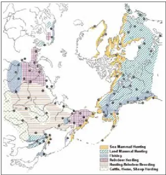
At the end of the ice age and the onset of warming, the steppe-tundra where mammoths lived gave way to forests, and the Arctic Ocean coast was covered with tundra. To survive in the new conditions, humans began to engage in a variety of subsistence activities. For example, in the tundra region, hunters drove wild reindeer herds into a river or a place surrounded by rocks. However, since there were few game species in the forest region, hunting decreased and fishing and gathering increased. Since game and fish availability depended on the season and location, small groups adopted a nomadic lifestyle in a constant pursuit of food.
I. The Origin of Permafrost and the Human History in the North
Domestication and Pastoralism
Some scientists hypothesize that wild reindeer were domesticated about 3,000 years ago, and there are several hypotheses regarding the origin and distribution of their domestication. For example, one theory asserts that reindeer were initially kept as hunting bait for wild animals, which subsequently led to reindeer herding. Another theory asserts that entire deer herds were tamed after being corralled as prey during a hunt. A third asserts that reindeer husbandry originated under the influence of horse breeding. Subsequently, in both the Western Siberia and Eastern Siberia tundra regions, large-scale reindeer husbandry is believed to have emerged from the 17th to the 19th century.
Fig. 3-3: Modern West Siberian nomadic reindeer herders
(photo by Y. Oishi, Shuryshkarsky District, Yamalo-Nenets Autonomous Okrug, 2016).
Fig. 3-2: Modern East Siberian hunter
15
I. The Origin of Permafrost and the Human History in the North
By contrast, in the Baikal region and the confluence of the Lena and Aldan rivers, people successfully engaged in nomadic pastoralism, including sheep, cattle, and horses, as in Mongolia and other steppe regions, alongside hunting.
Fig. 3-4: Traditional subsistence in the Northern Regions
(provided by Hokkaido Museum of Northern Peoples).
Permafrost and Culture
II. Permafrost and Culture
Chapter 4
Alases and Ecosystems
Alas Formation
The current mean annual air temperature in Yakutsk is about –8°C, which is quite cold even on a global scale. Central Yakutia has not been covered by a large-scale ice sheet for over two million years, so thick permafrost formed here. Permafrost in this area includes many ice wedges, and in Central Yakutia ice wedges lie about 1.5–2.5 meters below the surface. However, ice wedges are not found everywhere. They formed gradually from the effects of cyclical surface layer thawing and freezing in summer and winter during the last glacial period, from about 100–10 thousand years ago. In Central Yakutia, neighboring ice wedges often formed a single large underground ice mass called an ice complex or “yedoma.”
The Boons of Permafrost
The annual precipitation in Central Yakutia is only about 300 millimeters. Despite that, its territory is covered with coniferous forests (taiga), primarily larch. The two main factors underlying taiga’s existence here are (1) when the surface air temperature rises above 0°C in the summer, the surface layer thaws, forming an active layer; and, (2) permafrost is preserved under this active layer and does not absorb water or allow it to infiltrate. Thus, despite the small amount of precipitation, because of the active layer that forms in the warm season and the permafrost beneath it, trees can use the soil water in the active layer. (In lower latitudes with a similar precipitation environment, steppes form, because there are no underground permafrost layers.) The larch trees in Central Yakutia regulate their active layer soil water use in summer in accordance with precipitation levels. In rainy summers, the larch tree roots uptake soil water from the middle part of the active layer, and in dry summers, they uptake soil water from the deeper part of the active layer. Thus, larch trees benefit from the peculiar features of permafrost and the active layer. Moreover, the taiga on the ground surface protects the permafrost from solar radiation, and thus it does not thaw easily. This relationship between two elements, such as vegetation and permafrost is called symbiosis (e.g., a symbiotic or interdependent ecosystem). In the taiga zone with ice wedges, this symbiosis is continuously maintained if the climate is stable. However, when part of the forest is devastated, such as after a forest fire, permafrost will begin to thaw over time, creating swamps, lakes, and meadows. The landscape changes during this transformation are called thermokarst, and a thermokarst landscape characterizes the various craters, dips and alases, formed during the transformation.
19
II. Permafrost and Culture
Alas Classification
The thermokarst landscapes in Central Yakutia are divided into four groups, based on the formation stage. Cyclical season-driven ice-wedge thawing and freezing in the surface layer formed in treeless open areas causes a structural microtopography, where pingos and depressions (polygonal soil) resembling a tortoise shell form on the ground surface. This is the bullar stage. If a large forest fire completely burns the trunks and crowns, solar radiation will warm a wider ground surface, which facilitates ice-wedge melting in the surface layers of the soil, initiating reservoir formation. This thermokarst stage is a dyede. A newly formed bullar takes from several decades to hundreds of years to grow into a dyede. Then the lake expands and the dyede deepens by several meters compared to the surrounding area. On average, this type of landscape forms within 1000 years of the bullar formation and is called a tuumpu. At this stage, snow meltwater begins to flow intensively into the thermokarst depression and rainfall accumulates, eventually filling the entire basin with water. After that, a long drying process occurs, gradually turning the tuumpu into a spacious meadow with a lake in its lowest part. This type of landscape can take several thousand years to emerge after the formation of the bullar and is called an alas. There are over 16,000 alases in Central Yakutia.
Fig. 4-1: Numerous tuumpus and alases scattered across the taiga in Central Yakutia (photo by T. Hiyama, near the village of Tabaga, 2010).
II. Permafrost and Culture
Fig. 4-3: Alases generally have a hollow relief that is lower than the surrounding landscape (photo by A. Fedorov, Ust-Aldansky District).
Fig. 4-2: Exposure of permafrost in Central Yakutia. Underground ice complex (yedoma) is visible (photo by T. Hiyama, Churapchinsky District)
21
II. Permafrost and Culture
Chapter 5
Permafrost as a Space of Human Activity
The Origin of the Sakha People
Although there are several scientific hypotheses, it is generally believed that the Sakha people’s ancestors migrated from the southern Baikal region to the middle reaches of the Lena River in the 10th to 15th centuries. Their migration paths ran along both the Lena and Vilyuy rivers. When the Sakha people’s Turkic-speaking ancestors lived in the Baikal region, they had a hierarchical society with a military aristocracy. This is reflected in the modern Russian Federation Republic of Sakha’s coat of arms, a figure of the ancient horseman. The Sakha ancestors migrated to the north while maintaining their culture of steppe cattle breeding based on nomadic grazing of cattle, horses, camels, sheep, and goats. Since sheep, goats, and camels were not suited to the overly cold climate in the middle reaches of the Lena basin, a combination of hunting and breeding (primarily cattle and horses) became the Sakha’s traditional economic activity. Recent biological research identified a genetic affinity of the Sakha people in Central Asian and South Siberian groups.
Fig. 5-1: Sakha folk festival, Yhyakh. People sing and dance around the decorated ritual wooden pillar (serge) (photo by T. Hiyama, Elgeeii field station, 2010).
II. Permafrost and Culture
Human History Significance
Sakha migration to the middle reaches of the Lena River basin is of great importance because it reflects how humans adapted their lifestyle to environmental conditions. Before the Sakha ancestors arrived, human adaptation in Siberia involved a complex combination of hunting and gathering, fishing, and reindeer herding, which as similar to human lifestyle adaptations in the Arctic regions of North America. However, the Sakha, who originated from Mongolia and Central Asia, brought to Siberia a new method of adaptation: harvesting hay to provide winter feed for cattle. Instead of using animals adapted to Siberian conditions, the Sakha developed a lifestyle based on animals brought from southern regions. Moreover, the Sakha used traditional irrigation technology and artificially created meadows for harvesting hay.
Alases and Culture
How did the Sakha manage to develop cattle and horse breeding under Arctic conditions? It resulted from a series of accidents in the ecosystem history of Eastern Siberia, where a forest ecosystem predominates. Most of the Sakha ancestors who migrated to the middle reaches of the Lena River chose life in the alases scattered among the taiga forests, which contained lakes and pastures, providing a living space with fish and grass for grazing. There is even an expression for this in the Sakha language, “Alaas ogoto,” meaning “a native of an alas.”
23
II. Permafrost and Culture
These alases developed from thermokarst processes. The ice complex that supported the land surface melted, causing ground subsidence, and the resulting thermokarst process formed alases, where the remnants of unevaporated water formed lakes and meadows. The Sakha traditionally sought to discover the full value of nature as formed by permafrost and to preserve the culture adapted to this nature.
Fig. 5-3: Net fishing on a lake in an alas (photo by A. Nakada, Churapchinsky District, 2017).
II. Permafrost and Culture
Chapter 6
The Impact of the Soviet Union Dissolution
on Villages
Anthropogenic Environmental Changes
Environmental changes are not only caused by natural factors, but are frequently associated with changes in human society. Changes in the Republic of Sakha’s natural environment driven by climate change that occurred over the last 30 years coincided with the turbulent years associated with Soviet Union dissolution. Reviewing the Soviet era provides insights on changes in the relationship between humans and nature that occurred in connection with changes in human society.
State Farms of the Soviet Era
In the Soviet era, the main agricultural enterprises and farms were state-owned and managed. After the socialist revolution, repeated fragmentation and unification led villages to organize collective farms (later merged into state farms). In parallel with cultivating wheat and fodder crops, the state farms also conducted intensive animal husbandry to breed cattle, horses, reindeer, etc. Soon after the Soviet Union dissolution, state farms were also dissolved, and state farm property (land, livestock, agricultural machinery, etc.) was divided among former state farm workers. Subsequently, some of these workers established new agricultural enterprises and cooperative associations, while others became independent farmers. The collapse of the state farm system profoundly changed the system of agriculture, causing many challenges.
The Distance between Alases and Villages
Before collectivization, the Sakha lived as dispersed individual families on vast tracts of land, seasonally moving between summer pastures and winter dwellings. When agriculture was collectivized, beginning in the 1930s, a policy of enlarging settlements was implemented, where people who had previously lived separately in meadow lands were gathered in a single location and had to adopt a new way of public life. As a result, many villages were built, but these were often very far from the ancestral meadows. In the Soviet era, this distance was not much of a burden, because the state farm command system made it possible to send workers to workplaces and remote meadows and to
25
II. Permafrost and Culture
allocate tractors and other equipment. After the Soviet state dissolution, the driving force of the state farm system ceased functioning, and movement between villages and pastures became difficult for local residents.
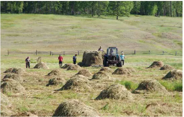
Hay Harvesting
Today, villagers with livestock harvest hay for winter on their own. In the Soviet era, all young people who graduated from school, regardless of where they worked, would be sent to state farms for a period to help harvest hay. They even held competitions on the volume of the hay harvested. Today, young people increasingly migrate to cities, moving away from agriculture, resulting in a critical shortage of agricultural labor. In addition, agriculture fragmentation also poses other problems. No one wants to use the remote meadows because transporting hay over long distances involves high fuel costs. Consequently, many meadows are being abandoned and vast areas of agricultural land are declining.
Deforestation
Shortages of wood for fuel and building material are also becoming more acute. In the Republic of Sakha’s rural areas, where most people heat their houses with wood and the average air temperature does not rise above zero for six or more months, it is vital to stockpile large amounts of firewood. Since it is now effectively impossible to rely on organized collective work, which once allowed firewood delivery from remote forests, nearby forests around the villages are being felled in a mostly uncoordinated manner.
Fig. 6-1: Harvesting hay in the 1960s, Gorny District (photo provided by the editorial staff of the newspaper “Ule Kuuhe”).
II. Permafrost and Culture
Global Warming and Ice
III. Global Warming and Ice
Chapter 7
Warming and Permafrost
Warming in Recent Years
In recent years, permafrost in Eastern Siberia has been heavily affected by climate change in the Arctic. The Arctic experienced a period of warming in the middle of the 20th century (1935–1945), which localized in Eastern Siberia with the temperature rise manifesting only in the tundra zone along the coast of the Arctic Ocean. However, since the 1990s, there has been a clear tendency toward warming in wider territories. In the 2000s, warming was observed in all of Eastern Siberia, with increased mean annual air temperature that increased the thawing index in the summer season and inversely decreased the freezing index in the winter season (Fedorov et al., 2014a). The warming has induced changes in the permafrost environment; the permafrost upper layers are starting to thaw more intensively in summer and do not freeze as much in winter.
Fig. 7-1: Warming by region in Eastern Siberia (Fedorov et al., 2014a): (a) changes in the mean annual air temperature; (b) changes in thawing index.
29
III. Global Warming and Ice
Humidification Effects
In Eastern Siberia, another aspect of climate change—increasing humidity—has been observed in addition to warming. Between 2004 and 2008, the levels of snow falling in winter and rainfall in summer significantly exceeded the long-term average, leading to an excessively moist environment on the ground surface and within the active layer. This wet environment decreased the volume of harvested hay, which negatively affected livestock production (Takakura 2016). It also affected the hydro-thermal state in the underground, where the soil within the active layer was filled with excess water driving remarkable changes in the heat and moisture balance. For example, the active layer thawed deeper in summer, and the soil within the active layer retained the high moisture state over subsequent years. In the larch forests (taiga) near Yakutsk, the active layer thickness was previously less than 1.2 meters, but increased to two meters or more in 2009 following the increased soil moisture (Iijima et al., 2012). A 1.5 to 2 meter increase in the active layer thickness was manifested along valleys with smooth slopes and on the plains, where the concaved relief reproduced the water accumulation, corresponding to the distribution of underlying permafrost. In this topography, the soil moisture accumulates in the lower part of the active layer.
Permafrost Degradation
When the active layer thickness deepens enough to reach the underground ice mass (yedoma), the underground ice begins to melt, resulting in ground surface subsidence (thermokarst). In the basin between the Lena and Aldan rivers in Central Yakutia, the depth of the underground ice complex is two meters or more. In places where the taiga (larch forest) is healthy, vegetation and soil organic matter restrain the influence of thermal changes and active layer depth remains stable at 1.0–1.5 meters. The layer in between the active layer and the underground ice complex is called “shielding layer.” This layer buffers the effect and prevents thermokarst development. If forest degradation
III. Global Warming and Ice
occurs as a result of economic activity or wildfire, the ground temperature and active layer thickness both increase. Eventually the thawed layer reaches the underground ice complex, destroying the shielding layer and allowing thermokarst to develop. Then, meltwater from the underground ice and runoff from surrounding water accumulate to form a thermokarst lake.
Thermokarst Lake Growth
Thermokarst lakes newly formed from warming over the past several decades predictably increase in size, regardless of the degree of moisture or dryness in each particular period. For example, in one thermokarst lake in Central Yakutia, the surface area increased by 16 times and the volume by 104 times between 1993 and 2008, with an estimated one-third of the water coming from melting underground ice (Fedorov et al., 2014b). During the wet climate period between 2005 and 2008, there were forests where the depth of the active layer increased because of water accumulation, leading to thermokarst development. Such cases should be a focus of attention, since they indicate permafrost degradation resulting from a combination of natural factors (increased warming and humidity) even in the absence of human disturbances. In the alases, certain changes also occur that cause unfrozen layers on permafrost (taliks) to develop, but do not lead to significant changes in the relief. As mentioned previously, the alases were formed from gradual permafrost thawing over 6,000 years and are a symbol of permafrost and human symbiosis.
31
III. Global Warming and Ice
III. Global Warming and Ice
Chapter 8
The Impact of Environmental Changes
and the Reaction of Local Residents
in East Siberia
Questionnaire
What do the Sakha people think about the environmental changes in their place of residence? What problems do residents face because of environmental changes? In this section, we discuss the results of a questionnaire and interviews (Fig. 8-1) conducted with residents in the village of Khayakhsyt (located about 120 km east of Yakutsk) in the permafrost development zone (see Chapter 4).
Personal Experience and Reflection on Environmental Changes
More than 70% of respondents experienced house and building subsidence and house floor deformation (Fig. 8-2). In addition, about 20% of respondents mentioned flooding of a dwelling site. These responses reflect direct personal experience associated with changes in the environment.
It should also be noted that many people experienced the negative impact of environmental changes in their economic life, especially regarding livestock and feed
33
III. Global Warming and Ice
resources. For example, about 90% of respondents experienced the negative impact of unpredictable winter temperatures on their horses and more than 80% experienced hayfield flooding and other effects. Respondents also indicated that ravines have developed in the area from the effects of precipitation and meltwater from frozen soil thawing. The results of this sociological study show that many villagers directly experienced the negative impact of the environmental changes, including flooding and deformation of residential buildings, and deterioration of livestock-keeping conditions.
Challenges Faced by Locals
What challenges do the locals face? Their responses to this question are shown in Fig. 8-3. Most respondents reported household economic problems, such as the rising price of food and commodities. The second most frequently mentioned challenge was environmental change in their settlement. In addition, various problems related to
Fig. 8-3: Challenges faced by locals
III. Global Warming and Ice
everyday life were cited, such as social welfare and pensions, health problems, etc. It was also clear that respondents were paying close attention to problems related to environmental changes.
The results showed that Yakutia’s rural residents experience different impacts from environment changes, and many of them see these changes as important problems that affect their residences.
Measures to Counter the Impact of Environmental Changes
In response to environmental changes, Sakha has implemented various independent (e.g., involving individual residents) and collective measures with the support of local communities and authorities, such as leveling the ground surface where thermokarsts developed; constructing embankments under residential buildings to prevent leaning; cultivating crop varieties best suited to the ongoing climate change conditions, etc.
Fig. 8-4: Residential building with an embankment at the base (photo by Y. Fujioka, Churapchinsky District, 2016).
35
III. Global Warming and Ice
Changes in Livestock Population by Type of Livestock
The number of farmers in the region switching from cattle to horse breeding has increased in recent years. Fig. 8-3 shows livestock species population change dynamics in the Republic of Sakha as a whole, indicating that the cattle population is decreasing while the horse population is increasing. We believe that this is driven by both social and economic factors, such as changes in livestock market prices and husbandry practices, and the influence of environmental changes, as local residents indicated in their questionnaire responses.
The water from the frequent rains and thawing of permafrost flows into low-lying areas, decreasing meadow plots and making it more difficult to provide winter food for cows. In winter, cows stay in barns because of the cold, so they have to be supplied with a large amount of feed by hand, and horses can feed outside in winter, so it is preferable to breed horses, not cows.
Climate change, called global warming by some, manifests itself on both a planetary and local scale. As in the Sakha Republic in Siberia, people who live in rural areas continue their daily lives while facing complex interactions between cultural factors related to their traditional herding-based lifestyle and changing environmental factors. This readiness to confront new problems reflects both the historical culture that allowed the Sakha to adapt to Siberia’s cold environment by developing cattle breeding, and the people’s strong spirit. Global warming is an acute global problem, but local people have
III. Global Warming and Ice
the potential to counteract the challenges of environmental change they face in everyday life. However, to harness and expand this potential to the maximum possible extent, it is necessary to understand the specific situations and concerns in each individual region, and to significantly contribute to the efforts of communities and local authorities, national governments, researchers, foreign investors, and humankind in general.
37
III. Global Warming and Ice
Chapter 9
Greenland
Changes Occurring in the Ice Sheet, Glaciers, and Ice Caps
So far, we have discussed the impact of global warming through the Republic of Sakha example. Now let us look at what is happening in Greenland, located in the Western Hemisphere Arctic.
Eighty percent of Greenland’s territory is covered in glaciers with an average thickness of 1,700 meters. This huge mass of ice is called the Greenland ice sheet (glaciers that cover the land on the scale of a continent). In addition, the coastal areas have glaciers that are separated from the ice sheet and ice caps (domed glaciers covering hills and mountain peaks). The ice sheet, glaciers, and ice caps (hereafter, collectively referred to as “glaciers”) formed from snow accumulation; therefore, they differ significantly, both qualitatively and in appearance, from the permafrost in the Republic of Sakha. Greenlandic glaciers account for 10% of all ice on the planet. In recent years, the glaciers have been melting, with the volume of ice lost in the 10 years between 2000 and 2010 corresponding to a six millimeter sea level rise. Greenlandic glacier melting is a significant factor in global sea level change.
There are two main reasons for glaciers’ decreased area and volume: (1) under the influence of rising Arctic air temperatures, snow and ice are melting more intensively (Fig. 9-1) and glacier surfaces are darkening, which further facilitates melting; (2) glaciers are flowing into the sea at an accelerated rate, carrying a large volume of icebergs into the sea (Fig. 9-2). The factors driving these phenomena have not yet been fully elucidated. The volume of ice lost from glaciers melting and iceberg loss is greater than the volume of ice accumulated on land from snowfall. Therefore, Greenland is losing ice.
Indigenous Society
Siberia and Greenland are located on the opposite sides of the planet. Although both Greenland, the largest island worldwide, and Siberia are located in the Arctic there are large differences between the two regions; Siberia is a vast continental land area, while 80% of Greenland is covered by an ice sheet that is several thousand meters thick. With a population of 56,600 people (2018) Greenland has one of the lowest population densities worldwide. More than 80% of the population is concentrated in the southwestern portion of the country, with 30% of the total population living in the capital, Nuuk.
III. Global Warming and Ice
Fig. 9-1: Meltwater flows over the darkened ice. Qaanaaq ice cap near the village of Qaanaaq (77°N, 69°W) (photo by S. Sugiyama, Greenland).
Fig. 9-2: Icebergs carried to the sea from Bowdoin Glacier in the Qaanaaq area
(photo by S. Sugiyama, Greenland).
Fig. 9-3: Meltwater with sediment flowing from a glacier into the ocean. Northwest Greenland (photo by S. Sugiyama, Greenland).
Fig. 9-4: A bridge destroyed by a flooding river flowing from a glacier near the village of Qaanaaq (photo by S. Sugiyama, Greenland).
39
III. Global Warming and Ice
Most Greenland inhabitants speak the Greenlandic language’s standard dialect, Kalaallisut. Residents of the northern, western, and eastern regions speak their own local dialects, maintaining their regional identity. However, Kalaallisut is the official and common language, and is the dialect of the southwestern region, where most of the population lives and political and economic life are concentrated.
The History of Economic Activities
The ancestors of Greenland’s indigenous population are also the ancestors of Canada’s, Alaska’s, and Chukotka’s modern Inuit (Eskimos). These ancestors traveled from Northeast Asia 4,600 years ago and settled on small coastal areas not covered by the ice sheet. Their food sources included land animals, such as musk ox, caribou (wild reindeer), and tundra partridges; migratory birds (geese and ducks); marine mammals (seals, walruses, and polar bears); and fish (halibut, Arctic char).
Over the course of several thousand years, people adapted to changes in their habitat by changing their residence locations, lifestyle, and food prey in accordance with the conditions driven by cyclical warming and cooling. Until the 20th century, the only domestic animals in Greenland were dogs. Although wild reindeer lived in Greenland, unlike the Siberian people, the Greenlanders never bred them.
Approximately 1,000 years ago, the Scandinavians (Vikings) migrated to Greenland from Northern Europe via Iceland, settling in Southern Greenland for several centuries (until 1450). The Scandinavians named the island “Greenland,” meaning “green country.”
Fig. 9-5: Qassiarsuk, the recreated site of the Scandinavians (Vikings) (61°8’60’’N) (photo by S. Honda, 2013).
III. Global Warming and Ice
At the time, the island had a relatively warm climate, and in summer it was covered with lush green knee-high grass.
In the 1720s, a Lutheran missionary named Hans Egede came to Greenland from the Dano-Norwegian kingdom, paving the way for Danish colonization. The Danish government built schools in every village, used Greenlandic language textbooks, and generally pursued a relatively mild colonial policy aimed at “managing rather than reigning.” In 1953, Greenland became an integral part of Denmark; in 1978 its autonomy was recognized in relation to internal management issues (home-rule); and in 2009 the island obtained extended autonomy (self-rule).
Modernization and Warming
Hunting, fishing, and gathering economic activities have remained virtually unchanged since ancient times, but their mechanization is continually developing. In many places, dog sleds gave way to snowmobiles, and kayaks were replaced by aluminum boats with an outboard motor. At the onset of the 20th century, sheep husbandry was introduced in Greenland’s southern region, and the island is now completely self-sufficient in mutton production. Local potato production provides 10% of domestic needs, but the country is almost fully dependent on imports for most fruits and vegetables. It may seem that global warming would have a beneficial effect on sheep breeding and crop cultivation, but precipitation has been significantly reduced for several decades, causing water shortages for pastures and vegetable fields.
Fig. 9-6: Supermarket in the town of Tasiusaq
41
III. Global Warming and Ice
For all food products except seal and whale meat, which Greenland fully provides for itself, the island depends on imports from Denmark and other countries. In many towns, there are large supermarkets selling a rich assortment of imported groceries.
Greenland’s economic base is supported by lump-sum subsidies allocated by the Danish government without any spending goal restrictions, and by fishing and tourism income. In addition to concerns about shrinking sea ice and flood damage, there is a growing concern among the local population that further ice sheet melting from increased warming will lead to increased rare metals mineral mining and sea oil field development. Conversely, some inhabitants express hope that such changes would bolster economic independence and maybe even complete Greenland’s independence.
Deglaciation
Greenland’s glacier changes are especially noticeable in coastal areas, where the air temperature is higher and glaciers are in direct contact with the sea. If the coastal glaciers melt, this will have a huge impact on both the land and marine environments. Environmental changes in coastal areas also raise serious concerns regarding Greenland residents’ lives.
Let us consider the impact of glacial meltwater on the marine environment. Increased glacier meltwater discharge increases the flow of fresh water and sediment into the ocean (Fig. 9-3), which changes seawater properties and affects the marine ecosystem. Such environmental changes could be critical to the local population, since seafood, such as northern shrimp and halibut, are important economic resources. Marine environment changes will also affect traditional whaling and marine mammal hunting. Additionally, in recent years, glacier melting has caused river overflows, resulting in increased flooding (Fig. 9-4), another manifestation of environmental change. These floods are caused by both accelerated glacier and ice sheet melting and more frequent heavy rain events in the Arctic. Rivers are a water source necessary for human life, so changes in the river flow and water quality are critical.
Glacier changes also cause global environmental changes. As previously mentioned, ice thawing in Greenland is an important underlying factor in the rising sea level. Furthermore, the volume of fresh water entering the ocean from glaciers affects ocean circulation, which plays a major role in heat transfer on the earth’s surface. Over several tens of thousands of years, huge volumes of fresh water from Greenland have repeatedly flowed into the ocean, causing changes in ocean circulation leading to global climate change.
III. Global Warming and Ice
Fig. 9-7: Village in Greenland (Tasiilaq, 65°36’48’’N) (photo by S. Honda, 2015).
Perspectives for a
Sustainable Future
IV. Perspectives for a Sustainable Future
Chapter 10
The Reasons for Warming
from a Global Perspective
So, what are the mechanisms underlying global warming? How does it change the environmental interrelations between the Arctic and other parts of the earth? And what measures are the international community taking in connection with climate change in the Arctic?
Greenhouse Gases and Human Activities
Solar radiation warms the ground surface through the atmosphere, after which the infrared radiation emitted by the surface is absorbed by greenhouse gases in the atmosphere, warming the lower atmosphere and the ground surface (Fig. 10-1). This is how the mean annual air temperature of about 15°C was established on this planet. It is believed that if there were no atmospheric greenhouse gases, such as water vapor, carbon dioxide, methane, etc., the mean annual air temperature on the planet would be about -18°C. Global warming, one of the current great worldwide concerns, is an increase in surface air temperature resulting from increased concentrations of greenhouse gases in the atmosphere. An Intergovernmental Panel on Climate Change (IPCC) report stated that the global concentration of carbon dioxide in the atmosphere, which was 280 ppm in the pre-industrial era (1750), exceeded 400 ppm in 2013 as a result of increased human activity. Several types of greenhouse gases contribute to global warming; carbon dioxide accounts for 76.7%, methane for 14.3%, nitrous oxide for 7.9%, and chlorofluorocarbons (CFCs, HCFCs; chemicals that deplete the ozone layer) for 1.1%. Thus, the main cause of
Fig. 10-1: The mechanism of global warming caused by greenhouse gases (compiled by Hotaek Park)
45
IV. Perspectives for a Sustainable Future
global warming is carbon dioxide emitted into the atmosphere from burning fossil fuels (i.e., oil and coal).
Warming in Recent Years
The IPCC’s (2013) fifth report stated that over 132 years, from 1880 to 2012, the global mean surface air temperature increased by 0.85°C (Fig. 10-2). It also reported that increases in surface air temperature over the past 50 years most likely resulted from anthropogenic factors rather than natural variations. As shown in Fig. 10-2, the greatest temperature increase is observed around the Arctic region, where the temperature increases at a rate more than twice the average global rate. The report emphasized that warming in the Arctic region is influenced by decreased Arctic Ocean sea ice and advection of warmer atmosphere from the lower latitudes.
Impact on the Arctic
Permafrost (the soil layer that is frozen year round) is widespread in the terrestrial sub-Arctic regions. In recent years, drastic warming in permafrost zone soil temperatures have increased the active layer (the surface soil layer with a temperature of 0°C or higher) thickness.
Permafrost contains a large amount of ice and organic carbon. According to some reports, the organic carbon content is more than two times higher in permafrost than in the atmosphere (750 PgC). Warming also drives active thermokarst processes in the permafrost zone; when underground ice thaws, the ground surface depresses, and water
Fig. 10-2: Carbon dioxide concentrations, which continue to increase from human activities (above), and the significant Arctic temperature increase in 2010–2017 compared to the average for 1951–1980 (below)
IV. Perspectives for a Sustainable Future
accumulates in the resulting depression landscapes, forming lakes and swamps. At the same time, organic carbon contained in the permafrost layer decomposes under the influence of microorganisms, leading to increased atmospheric emissions of methane and carbon dioxide (Fig. 10-3). These emissions contribute to an increased concentration of greenhouse gases in the atmosphere, thereby accelerating warming.
The Answer Lies in Permafrost
The IPCC’s (2013) fifth report predicted that, even with a maximum reduction in anthropogenic greenhouse gas emissions in the future, by 2100 the global mean surface air temperature will increase by 0.3–1.7°C, and under the worst-case scenario, the temperature will increase by as much as 4.8°C. Of particular concern is the warming feedback, since an increase in surface air temperature contributes to permafrost thawing, causing an increase in greenhouse gas emissions, that in turn accelerates increased global mean surface air temperature. According to the latest simulation data, by 2100 permafrost zone emissions will reach about 250 PgC for carbon dioxide and about 5 Pg for methane (Fig. 10-4). As a warming factor, methane is about 30 times more potent than carbon dioxide, so the methane value (5 Pg) corresponds to the carbon dioxide of 150 PgC. However, the current model does not consider many complex Arctic processes that result from permafrost thaw, such as lake and swamp formation. Therefore, it is very likely that the influence of permafrost on global warming will significantly exceed all existing forecasts.
Fig. 10-3: Thermokarst development by permafrost degradation and greenhouse gas emissions (compiled by G. Iwahana).
47
IV. Perspectives for a Sustainable Future
Fig. 10-4: Comparison of projected future carbon dioxide emissions in the permafrost zone from warming (Schaefer et al., 2014).
IV. Perspectives for a Sustainable Future
Chapter 11
Political Systems and Sustainable Future
in the Arctic
Indigenous People and International Organizations
State governments and interstate cooperation play important roles in solving the problems associated with climate change in the Arctic, but international organizations formed by public groups, organizations, and state governments also play critical roles. The IPCC is studying the situation on a global scale, and the Arctic Council—an intergovernmental forum established in 1996 that includes Canada, Denmark, Finland, Iceland, Norway, Russia, Sweden, the United States, and organizations representing the Arctic’s indigenous people—actively engages in Arctic affairs.
Conventionally, decision-making in the international community was believed to be best conducted via international agreements and treaties ratified by states. However, it is becoming clear that states do not have sufficient ability to solve international issues. To maintain a sustainable management mechanism, it is necessary to move away from relying on decisions made by states acting in their own interests, and begin including a larger circle of people and groups in the decision-making process to increase management effectiveness. The Arctic Council endows various memberships, including “permanent participants,” which could increase participation by organizations representing the Arctic’s indigenous people, such as the Russian Association of Indigenous Peoples of the North (RAIPON). Founded in 1990, RAIPON unites 35 ethnic and regional organizations of indigenous small-numbered people from all regions in North Siberia and the Far East of Russia. Its scope includes 40 indigenous populations comprising more than 270 thousand people living in vast areas from Murmansk to Kamchatka, accounting for more than 60% of the entire Russian territory. This means that the Russian Arctic indigenous people participate in an international organization’s decision-making process on an equal footing with state governments.
Why was that right granted specifically to indigenous peoples? It stems from the legacy of the past; the Arctic’s indigenous people were main actors in Arctic human history until they were confronted with state governance. The Arctic’s modern history is characterized by colonialism, which involved a governance/subordination dynamic between the state and indigenous peoples. In recent years, there has been increasing support for recognizing indigenous people’s rights, reconstructing the worldview of indigenous peoples, and reconciling by building equal relations between the state and indigenous peoples.
49
IV. Perspectives for a Sustainable Future
Greenland Autonomy Organization
In Russia, despite various restrictions, the federal system provides a mechanism for participating in political decision-making from a regional and national standpoint. The Republic of Sakha is an example. But what about Greenland, which is an autonomous territory of Denmark?
In 1979, Greenland, owned by Denmark, was the first among the Arctic territories inhabited by indigenous people to receive the right of self-government. This allowed Greenland a high degree of autonomy, an elected representative body, called “landsting,” comprising 31 deputies, and an executive body (a land board) comprising several elected ministers. A characteristic feature of Greenland’s domestic political decision-making is a system that incorporates the indigenous population’s traditional knowledge in political decisions.
Scientific Knowledge and Traditional Knowledge
In political decisions on issues related to indigenous people’s culture and life (e.g., marine and land mammals, fish, etc.), the authorities consider traditional knowledge, which regards humankind as an integral part of nature, alongside scientific knowledge,
IV. Perspectives for a Sustainable Future
which tends to objectify the environment and consider it outside of the human-nature relationship. All decision-makers proceed from the same premise that the combination of and interaction between these two approaches facilitates more reasonable decisions.
For a long time, scientific knowledge was the primary source of important information driving management decisions. However, we do not currently have sufficient knowledge about the environment. In fact, practical difficulties sometimes arise during implementation of decisions arrived at through ordinary scientific monitoring. Conversely, indigenous hunters, who are in direct contact with the environment year around, observe and perceive it holistically, intuitively, and even spiritually, based on their experience, which facilitates a deeper understanding. Previously there was no channel for including their knowledge in the political decision-making process. The more current integrated use of both approaches aims to develop optimal solutions for adapting to the harsh natural conditions of the Arctic.
Traditional knowledge is expected to make a particularly effective contribution to animal conservation by establishing hunting periods, locations, and quotas, and resolving issues regarding animal treatment, hunting methods, reduced killing time, minimizing losses, etc. This way of thinking and the mechanisms adopted by Greenland have been evaluated as “the most advanced indigenous resource management system in the world.” However, there has also been criticism claiming that this system is merely a formality implemented for show; that hunters’ opinions based on traditional knowledge are not actually considered at all; and environmental management is arbitrarily conducted by scientists only. Clearly, this mechanism still needs to prove its effectiveness and viability.
Fig. 11-2: The roles of scientific and traditional knowledge in political decision-making in Greenland (compiled by M. Takahashi).
51
IV. Perspectives for a Sustainable Future
Chapter 12
The Arctic and Asia
Energy Resources and Asia
So far, we have discussed the impacts of global warming on the Arctic’s nature and society. But the changing Arctic, in turn, influences many world regions in various ways. Therefore, we will discuss some current aspects related to Asia.
Nearly all oil and natural gas consumed by Japan is imported from abroad, with approximately 87% of Japanese oil imports coming from the Middle East and about 6% coming from Russia. In addition, Japan is entirely reliant on imported liquefied natural gas (LNG), 9% of which comes from Russia.
In recent years, because of climatic Arctic Ocean changes, the sea ice area has decreased, simplifying delivery of machinery and equipment to the Arctic to facilitate producing and developing resources, and simplifying oil and LNG exports. Consequently, oil and natural gas production in the Arctic is developing at an unprecedented pace.
Construction of New Pipelines and LNG Plants
Being a great oil and gas power, Russia has been laying gas and oil pipelines for European export from Siberia—the main location of their oil and gas production. Around the mid-2000s, Russia began actively increasing exports to Asia. For example, an oil pipeline connecting the Siberian fields with a port near Vladivostok is now used to export oil to China, Japan, Korea, and other countries. Currently more than a quarter of Russian oil exports go to East Asia, meaning that part of the oil produced in the Republic of Sakha’s Talakan field is also consumed in Japan. A new plan is also being developed to implement natural gas exports to China from Siberia, particularly from the Chayanda gas field in the Republic of Sakha.
In 2009, for the first time in Russia, an LNG plant was built on Sakhalin Island, with most of the LNG produced there exported to Japan. At the end of 2017, a second plant was built on the Yamal Peninsula. When the ice thaws in summer, the LNG produced there is exported to Asia along the Northern Sea Route; in the winter the LNG is exported to Europe. It appears that Russia is striving to establish a leading position among the world’s major LNG exporters.
IV. Perspectives for a Sustainable Future
Northern Sea Route
The Arctic Ocean’s sea ice extent continues to decline. Consequently, in recent years coastal waters along the Russian Arctic coast are ice free for a certain period in summer. This has increased Russian Arctic coastal waters’ navigable period, while the navigational risk related to sea ice is decreasing. This provides new opportunities for the Northern Sea Route, which passes through the Arctic Ocean along the Russian coast and connects the Atlantic and Pacific Oceans. The Northern Sea Route functions as both a maritime transport artery for Russia’s coastal regions and a global maritime transport route between Europe and Asia.
For example, transporting LNG from the Yamal Peninsula is expected to involve over 160 round-trip voyages per year (15 specialized gas tankers will operate between Yamal, Europe, and Asia). By facilitating Russian LNG production in the Arctic, the Northern Sea Route will become an important new transport corridor for energy resources. Currently, the Northern Sea Route is also being used for sea freight transport between Europe and Asia and tourist cruises in the Arctic Ocean. Using the Northern Sea Route for shipping between European and Asian ports reduces the distance by 30–40% compared to the usual route through the Suez Canal. However, safe navigation of the Northern Sea Route requires specialized cargo ships that can navigate in ice infested waters, and when the sea ice is severe, Russian nuclear icebreaker support, provided on a paid basis, will be required.