Sedimentary Basin in the Uplift Belt of Inner
Arc: Case of the Nishime Sedimentary Basin in
the Dewa Hills, Northeast Japan Arc
著者
Otsuki Yoshinori
雑誌名
The science reports of the Tohoku University.
7th series, Geography
巻
50
号
1
ページ
35-57
発行年
2000-06
URL
http://hdl.handle.net/10097/45247
Tectonic Processes of a Pliocene Pleistocene Sedimentary
in the Uplift Belt of Inner Arc : Case of the Nishime
Sedimentary Basin in the Dewa Hills,
Northeast Japan Arc
Basin
Yoshinori OTSUKI*
Abstract In the Northeast Japan Arc, uplift ranges and subsided sedimentary basins form topographic rows parallel to the north-trending arc and trench, and their arrangement reflects the neotectonic movement of the arc-trench system due to the horizontal shortening stress field in the east-west direction. To reconstruct the detailed tectonic processes of the Dewa Hills, one of the remark-able uplift belts in the inner zone of the Northeast Japan Arc, this paper aims at elucidating the Latest Cenozoic succession of the Pliocene-Pleistocene Nishime Sedimentary Basin in the hills. In the Nishime Basin accompanying the Nishime Syncline, the Pliocene Tentokuji and Sasaoka Formations of marine origin, the Nishime Formation of latest Early to early Middle Pleis-tocene age, deposited under neritic to fluvial environments, and the Yurihara Debris Avalanche Deposits flowing down the Chokai Volcano in middle to late Middle Pleistocene time, are well-exposed in ascending order. The Last Interglacial thalassostatic terrace surface, namely Hj-M1 Surface, is frag-mentarily present in the north of the basin.
The Nishime Sedimentary Basin continued to exist as a relative subsided area accompanying the movement of the Nishime Syncline from the earliest Pliocene, and filling by a sequence of basin-fills was completed before the deposition of the Yurihara Debris Avalanche in the middle to late period of Middle Pleistocene age, caused by the extinction of the syncline. Since then, the regional uplift has predominated in the whole of the Nishime Basin up to present, and the basin is no longer an active sedimentary basin. The Nikaho Thrust Faults situated on the western fringe of the basin, partly promoted the growth of the Nishime Syncline, but are inferred to have also moved since Late Pleistocene time. From these and some data on the other sedimentary basins in the Dewa Hills, it is concluded that both the uplifted and subsided areas were concurrent during the time from the early Pliocene to the Middle Pleistocene in the Dewa Hills. In contrast, the hills are considered to have grown since Middle Pleistocene time until present as a single uplift zone restricted at its western margin by the Kitayuri Thrust Fault System.
* Institute of Geography, Tohoku University, Sendai 980-8578, Japan Science Reports of Tohoku University, 7th Series (Geography) Vol. 50, No. 1, June, 2000, 35-57
Key words : Latest Cenozoic, Middle Pleistocene, neotectonics, sedimentary basin, Nishime Basin, Kitayuri Thrust Fault System, Dewa Hills, Northeast Japan Arc
1. Introduction
In the Northeast Japan Arc, one of the most typical island arcs on Earth, uplift
ranges and subsided sedimentary basins form topographic rows parallel to the
north-trending arc and trench, that is, from west to east in the terrestrial area, the Coastal
Lowland along the Japan Sea, the Dewa Hills, the Inland Basins (the Intermontane
Sedimentary Basins a: Nishime b: Wada c: Takanosu d: Shonai e: Niigata f: Odate Japan Sea e C#7
g
0 2 )4 E21 I 1-1111 6 dz‘c)j<
4 111 . .1 5Cg
' (i) 0 . 0 c.) 14 7 ..,. c.) crf 44 50 kmFig. 1 Uplift ranges and sedimentary basins of the Northeast Japan Arc (terrestrial area)
1 : Dewa Hills 2 : Inland Basins (Intermontane Basins) 3 : Ou Backbone Range 4 :
Mabechigawa-Kitakarnigawa-Abukumagawa River Basins 5 : Kitakami-Abukuma
Basins), the Ou Backbone Range, the Mabechigawa-Kitakamigawa-Abukumagawa River Basins, and the Kitakami-Abukuma Massif (Fig. 1). Their arrangement and growth reflect the Latest Cenozoic tectonic movement of the arc-trench system due to the regional stress field in which a maximum compressional principal axis trends eastward. Especially, the inner zone of the Northeast Japan Arc, on the west side of the Ou Backbone Range in which the volcanic front is situated, have been subjected to more notable horizontal shortening deformation during the Late Cenozoic (Sato, 1989), or Quaternary time (Kaizuka and Imaizumi, 1984).
The Dewa Hills, accompanied by the Kitayuri Thrust Fault System' (Ozawa et al., 1984) which is traceable for a distance of about 200 kilometers along the western margin of the hills, are one of the remarkable uplift belts in the inner arc of Northeast Japan and have evolved under that tectonic trend. It is, however, inferred that the Dewa Hills have not been uplifted through a simple process since the Kitayuri Thrust Fault System started to move, because several Pliocene-Pleistocene sedimentary basins are present in the hills (e.g. Otsuki, 1991, 1995a, b, 1999a, ID). In order to reconstruct the detailed tectonic processes of the remarkable uplift belt in the arc, it is necessary to clarify the Latest Cenozoic succession of these basins. The aim of this paper is to elucidate the Uppermost Cenozoic stratigraphy and structures, and the tectonic evolution of the Nishime Sedimentary Basin, as an example of these basins in the Dewa Hills.
2. Geologic and geomorphic setting around the Nishime Basin
As shown in Fig. 2, the Nishime Sedimentary Basin, near the Japan Sea coast, Akita Prefecture, is situated at the northern foot of Mt. Chokaisan (Chokai Volcano), accompanying the Nishime Syncline. In the vicinity of the basin, a hilly area (Yuri-hara Plateau) is widespread and the hill-top surfaces, which range in altitude from 150 to 600 meters, correspond to the depositional surfaces of Middle Pleistocene debris avalanche deposits (Yurihara Debris Avalanche Deposits) originating from the Chokai Volcano. Along the Nishimegawa River, which flows northward from the Yurihara Plateau into the Japan Sea, the alluvial plain extends an approximately width of 1 to 3 kilometers from east to west, and of 5 kilometers from north to south (Fig. 3). A small-scale sand dune is recognizable along the Japan Sea coast, and Late Pleistocene fluvial terraces are fragmentarily present in the north of the basin and along the Koyoshigawa River.
The Nishime Syncline has deformed several formations ranging from the Middle Miocene to the Middle Pleistocene, that is, the Aosawa, Onnagawa, Funakawa, Tentokuji, Sasaoka, and Nishime Formations in ascending order (Ozawa et al., 1977, 1988). The synclinal axis is presumed to run for a distance of about 20 kilometers in
5")
^ /V."" 1: ... \ \ o17rtiC.
*e
.
..'—)
I
1 i I) /(
2 —
—
-
' ,
1 . Omonogawa Riverit---, 1 ‘ 1 AkitaIP''. .Wada.•• ion
)11)
.
Lk
KII.
i oili.
'10
. ..
. -.'.
. ., .. .. . , r i i 1 i.0o\_,.7 I *:„. ( Japan Sea 1 — i 100 -:..., i N'..,% .(?),200\.../;._
Koyoshigawa River Honjo , j / -.• r, _ --- 1 ( Fig. 3 / '..-: , (--$ 0/1....
':, ) -..._,
Q)
rf
500)1?/'
C) r 0 ti..._.
300
•
.. *,,
300- r?..\-4. '... )10km1
CChokaiVolcanor**6),`:,
Fig.2SummitlevelmaparoundtheNishimeSedimentaryBasin ThickdashedpolygonindicatesthecentralpartoftheNishime. contour interval : 100 m 500 —--\ ..500 ... 300j . 300100 ". • •frY'lr-'...
..-... ChokaiVolcanor"t"°:*44r
?.0‘
,.' /1:-,- -\--•'-' 10 km i --/- ----441/4-N11. -1P' •• l/r., ^ , ON r' (1.: f"--1 ...% (w e2 Summit level map around the Nishime Sedimentary Basin
Thick dashed polygon indicates the central part of the Nishime Basin (see Fig. 3).
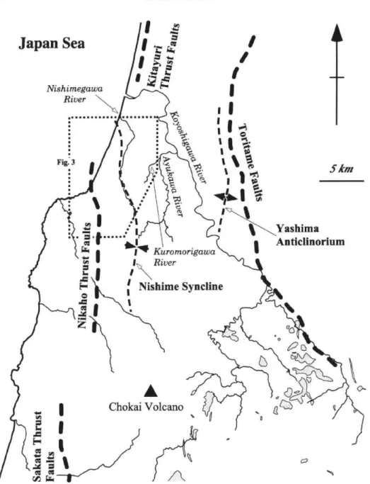
a southerly direction and to reach almost the Chokai Volcano, though the detailed axial trace remains unknown in the south of the basin because the folded formations are thickly covered with the Yurihara Debris Avalanche Deposits. The Nishime Basin is restricted by the Nikaho Thrust Faults (Ozawa et al., 1982), part of the Kitayuri Thrust Fault System, on its western side, and by the Yashima Anticlinorium (Ozawa et al., 1988) and the Toritame Faults (Toridame Fault : Kutsuzawa and Kim,
1966) on its eastern fringe (see also Fig. 11).
3. Stratigraphy of the central Nishime Basin
Figure 3 shows the geology and geologic structures of the central part of the basin.
Upper Neogene and Quaternary series exposed in this area are divided into the
Tentokuji, Sasaoka, and Nishime Formations, Yurihara Debris Avalanche Deposits,
fluvial terrace deposits, landslide detritus, and alluvial deposits in ascending order (Fig.
4). The principal formations of these are described as follows2).
3.1. Tentokuji Formation
Omura (1928) named the Tentokuji Formation whose type locality was originally near Tentokuji, Akita City, about 40 kilometers north of the Nishime Basin. In the investigated area, it crops out on the east of the Nikaho Thrust Faults, that is, on the hanging wall of the thrusts.
The formation consists mainly of bluish gray to dark bluish gray siltstone and intercalates some bluish gray to yellowish gray sandstone. Semi-consolidated marine siltstone shows a massive or parallel-laminated structure in its facies, locally grading into very fine sandstone. Sandstone is composed chiefly of massive or parallel-laminated fine (to medium) sandstone, as well as the siltstone. The formation in this area contains pebble and fine pebble conglomerate, and several interbeded layers of acid tuff and sandy tuff in places.
Ozawa et al. (1982) implied that the Tentokuji Formation was of early Pliocene age in the study area. Moreover, it was also reported to range in thickness from 700 to 1,000 meters and to conformably overlie the Funakawa Formation.
3.2. Sasaoka Formation
This formation was also named by Omura (1928) and its type locality is situated at Sasaoka in Akita City. In the study area, it is exposed near the northern boundary between Nishime Town and Nikaho Town, and along the Ayukawa River and the lower part of the Koyoshigawa River.
The Sasaoka Formation of marine origin principally comprises dark bluish gray to bluish gray siltstone, and also contains bluish gray sandstone and white acid tuff. Siltstone which contains abundant pyrite is semi-consolidated and massive or parallel-laminated, and commonly grades into very fine sandstone. Sandstone is mainly well-sorted, semi-consolidated fine, rarely to medium, and is locally rich in argillaceous matrix. Some thin acid tuff layers, that is, sandy tuff and fine tuff layers are recogniz-able in the formation.
40°N 140°E 142°E Koyoshigawa River Japan Sea 21 Honjo a A-21 O .1?„; 55
•7
ii•: NikahoThrust Faults .;;O::::::••:
/___,/;.(
Nikaho
...
•AI I ,
•. Ill
4 1
.42kr, 65 6.:4,
16*)-\\18
1\ 66 • '*.A• . • 2,, • —4,16 15 1 Nishime e: IM Xt= 2 .j,`;3),; 12-d .‘\ • eS B ,^^ 1••• NW. • . „ • :io
i=vfl
tIrFiri\
`,:z c- d Tonal 22:541 2‘. • • •^^ :;; Cl. 43 ' •••; =1O .T, —J17 • . . . . ... ." ‘5410" ... A 1 2B'
2 km 1C fq 11 12 3 40 r;;;',1
5
11 6[I1{1
8
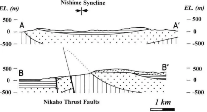
EL. (n) 500 — n —A Nishime Syncline -pp+. .• • 500 — •- B' - 500 0 _ • • • • - • - - - - • • . . . . . . . -500 -. • • — -500
Nikaho Thrust Faults 1 km
c=11^11
Fig. 3 Geological map and cross section of the central Nishime Sedimentary Basin 1 : alluvial deposits (including the Holocene terrace deposits), Kisakata Debris
lanche Deposits (ca. 3 ka), and Hj-L Terrace Deposits (partly omitted in cross section)
2 : landslide detritus (omitted in cross section) 3: M2 Terrace Deposit 4:
M1 Terrace Deposit 5: Yurihara Debris Avalanche Deposits 6: Nishime
tion 7 : Sasaoka Formation 8 : Tentokuji Formation 9 : fault (dotted where
cealed) 10 : syncline 11 : landslide scarp 12 : position of cross section a-e :
locality K* : Kuromorigawa River
EL. (m) — 500 A'
- 0
rests almost comformably upon the Tentokuji Formation because both of them resemble each other in lithofacies near the boundary between the formations. The Sasaoka Formation yields several kinds of molluscan fossils assigned to the Onma-Manganjian Fauna (Ozawa et al., 1977, 1982, 1988), one of whose type areas is at Manganji, Honjo City, slightly out of the area investigated. Sato et al. (1988) conclud-ed that the Sasaoka Formation in the Akita Oil Field was of late Pliocene age, basconclud-ed on the analysis of calcareous nannofossil assemblages. The formation in the basin is considered to be nearly correlative with that in the Akita area.
3.3. Nishime Formation
The Nishime Formation was first described by Mitsuchi (1938), and its type
locality (Loc. b : Figs. 5 and 6) is at Takou, Nishime Town, in the north of the basin.
It occurs around the Nishimegawa River and in the vicinity of the Innai Oil Field,
Nikaho Town.
The formation is represented by sandstone and pebbly sandstone, in places with
conglomerate, siltstone, acid tuff, and lignite (Fig. 5). It is difficult to regionally trace
a contemporaneous sequence in the formation, because it contains scarce key beds such
as acid tuff and because change in its lithofacies is quite notable laterally.
Holocene Late Pleistocene Middle Pleistocene Early Pleistocene Pliocene Late Miocene 0.01 Alluvial deposits • .•.•.-.•.•.•.•.•.-... . . . .... . Hj-L Terrace Deposits . • . • ... . . Hj-M2Terrace Deposit Landslide detritus . . . . . . . ... . ... 0.13 0.73 Hj-Ml. Terrace Deposit . . . . Yurihara Debris Avalanche Deposits . . . . Nishime Formation 1.64 5.1 (Ma) 99 Sasaoka Formation Tentokuji Formation Funakawa Formati on Fig. 4 marine terrestrial
Stratigraphy of the Uppermost Cenozoic in the Nishime Basin
Nishime Basin, includes an abundance of well-rounded fine pebbles and granules,
accompanied by some charred materials and redeposited pumice layers.
Cross-bed-ding in the sandstone is extensively recognizable and slump structures rarely occur in
it, as mentioned below (Fig. 7). These sandstone and pebbly sandstone in the upper
part of the formation, are inferred to have been deposited under a fluvial environment,
particularly near the lower course of the river. On the other hand, marine,
semi-consolidated, bluish gray fine sandstone, partly tuffaceous, in which pyrite is largely
crystallized, dominates in the lower part of the formation, sparsely including charred
materials and reworked pumice grains. Conglomerate mostly contains well-rounded
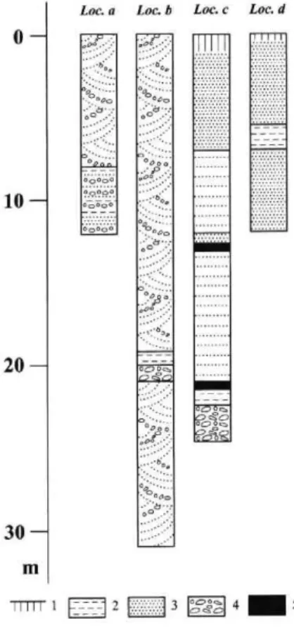
0 10 20 30 — m rim Loc. a ope 0.000 Loc. I) o Loc. c Loc. d opoq p on 11111 1 2 3 rg:02:1 4 5
Fig. 5 Lithofacies of the Nishime Formation
1: weathered part (surface soil) 2 : silt and clay 3 : sand 4 : Loos. a to d are shown in Fig. 3.
gravel 5 : lignite
(-biotite) rhyolite, acid tuff, and andesite with fine-grained phenocrysts. The clast
content in grain size distribution is considerably variable, and a clast-supported
structure is locally observable. The matrix of the conglomerate is largely
medium-to coarse-grained sand. The conglomerate is less continuous laterally, and grades
into pebbly sandstone and sandstone in general. Basal conglomerate can be
recog-nized in the west of the basin. Siltstone, occasionally sandy, colored dark gray or
grayish white, is semi-consolidated or unconsolidated, and contains charred materials
and pyrite. Acid tuff is semi-consolidated to unconsolidated grayish white fine tuff
and sandy tuff, and is generally poor in its lateral continuity.
The lithofacies of the Nishime Formation as mentioned above, suggest that the
formation was deposited under various sedimentary environments, that is, neritic to
fluvial. Overall, based on the fact that marine deposits are predominant in the lower
^^ •
.• r
g •
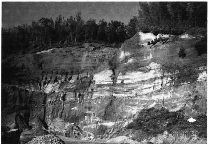
Fig 6 Nishime Formation at the type locality (Loc b) at Takou, Nishime Town The upper part of the Nishime Formation, namely unconsolidated, cross-laminated
fine to medium sandstone of fluvial origin is exposed It contains thin gravel and (lignite) silt layers (Iess than 1 meter thick).
4 "
pe locality (Loc b) at Takou, Nishime Town
Nishime Formation in the basin is considered to have been deposited during continuing
relative marine regression.
The formation has an estimated thickness of 200 to 400 meters, and
unconforma-bly covers the Sasaoka Formation (partly conformably in the center of the basin ?),
especially in the western part of the Nishime Basin (Fig. 3). The Tohoku Regional
Agricultural Administration Bureau (1982) described the occurrence of Juglans
siebol-diana in plant remains obtained from the Nishime Formation. According to Suzuki
and Nasu (1988), Juglans sieboldiana (Juglans ailanthifolia) appeared in Japan after the Jaramillo Subchron, that is, the latest Early Pleistocene time, based on the data of the
Uonuma Group, Niigata Sedimentary Basin. The Yurihara Debris Avalanche
Deposits overlying the formation, as stated in the following section, were deposited in
the middle to late Middle Pleistocene. From these the Nishime Formation is
correlat-ed with the uppermost Lower Pleistocene to the lower part of the Middle Pleistocene.
3.4. Yurihara Debris Avalanche Deposits
The Yurihara Debris Avalanche Deposits were renamed by Ozawa et al. (1988), and are distributed all over the Yurihara Plateau situated between the Japan Sea coast and the Koyoshigawa River. Itagaki (1992) inferred that the present Koyoshigawa River Valley did not exist in the age when the Yurihara Debris Avalanche was deposited because the debris avalanche deposits are not distributed to the east of the
present Koyoshigawa River Valley, and that an elongated depression sloping north-ward is discernible beneath the debris avalanche deposits in the Yurihara Plateau.
The debris avalanche deposits consist mainly of the boulder- to cobble-sized rubbles of andesite containing medium-grained plagioclase as phenocrystic minerals, with the interstitial material being chiefly brown volcanic sandy silt and clay. The clast content in grain size distribution are approximately 20 to 30 percent, but their variety is fairly large. Andesitic lava and pyroclastic flow deposit locally accompany the debris avalanche deposits. A several-meter thick pyroxene andesite lava can be recognized at the base of the Yurihara Deposits, at an outcrop in the upstream of the Kuromorigawa River, Yuri Town, in the eastern part of the investigated area. Similarly at the base of the deposits, a pyroclastic flow deposit is observable near the Innai Oil Field. The Yurihara Debris Avalanche Deposits are made up of several kinds of deposits and rocks, and is presumed to be subdivided into some stratigraphic units ; their detailed distribution and stratigraphy, however, still remain unknown.
It was reported that the Yurihara Debris Avalanche had flowed down the Chokai Volcano after the formation of a large stratovolcano, that is, during the time between Stages I and II in volcanic activity (Hayashi, 1984, 1985 ; Ozawa et al., 1988 ; Itagaki, 1992). Ban et al. (1989) inferred that the older debris avalanche deposits') around the Chokai Volcano date from 0.40 to 0.13 Ma, on the basis of K-Ar ages of the eruptive products in Stages I and II. The Yurihara Debris Avalanche Deposits, a part of the older deposits, therefore, are of middle to late Middle Pleistocene age. They have been estimated to be 30 to 80 meters thick by Ozawa et al. (1988), and 20 to 120 meters thick by Itagaki (1992) from borehole data. The deposits have an unconformable relationship with the underlying Nishime Formation.
3.5. Hj-M1 Terrace Deposit
In the vicinity of the study area, fluvial terrace surfaces are distributed largely
along the Koyoshigawa River. Specifically, Hj-M1 and Hj-M2 Surfaces are presumed
to be Late Pleistocene in age, and Hj-M1 Surface exists at Funaoka, Honjo City, in the north of the area.
Hi-M1 Terrace Deposit is composed largely of sorted pebbles and cobbles of
rhyolite, acid tuff, and andesite, with the matrix consisting of sandy silt. The clast
content in the terrace gravel is about 30 percent, and a matrix-supported structure can
be observed in the deposit. In the uppermost part of the deposit, a 90- to
100-centimeter thick yellowish gray sandy silt similar to the matrix in the gravel is
discernible, and this is considered to be the terrace-emerging horizon. The deposit is
covered with brown tephric fine-grained soils which are 1.4 meters thick ; no marker
tephra layer, however, can be currently found in the tephric fine-grained soils.
emerged in the Last Interglacial from its altitudinal arrangement and the degree of the
terrace deposit weathering. The thickness of Hj-M1 Deposit is estimated to be less
than 10 meters. The deposit overlies the eroded surface of the Nishime and Sasaoka
Formations, and probably the Yurihara Debris Avalanche Deposits.
4. Geologic structures of the Uppermost Cenozoic in the Nishime Basin 4.1. Nishime Syncline
In the study area, the axial trace of the Nishime Syncline extends northward nearly along the Nishimegawa River (Fig 3). On the eastern limb of the Nishime
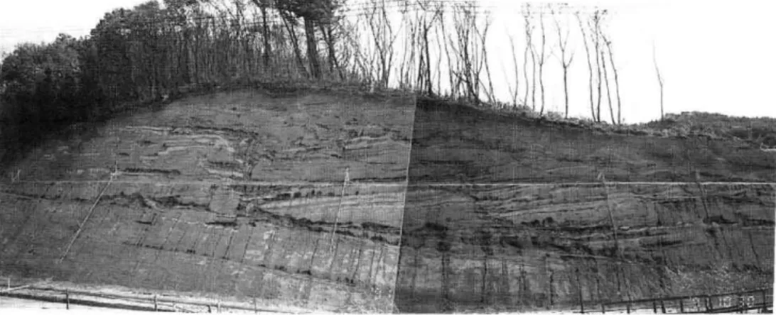
-; r, • 4. • s7-1 • . "ti°,e0.• • ca 5m N18'W7°W ' I H i 1 ova° 2 - 3
Fig 7 Meta- or syndep eastnalimbofthNi Fig.3) 7Meta-orsydeposition1slumpstructuresintheNishime eastrnlimboftheishinie(LoceatNakazav‘aNishir Fig.3)
Slumping occurredalonthbddmplaneoftheNishime Fon
considered to ha\eiesultedfromthe(Jinnonthesynclinallimb
1: weathered part(suifacsoil)2ravel(finephbleto pebble
and clay 5 slip surface of slumping
-WILT'
• ---•• -• .. .. •-• O W7°WN361,1713°E N72 `E 45"N 45hedeposition1slumpstructuresintheNishimeFormation ishinie(LoceatNakazav‘aNishime Town See also on the ed alon th b cldin plane of the Nishime Formation, and this is ‘e iesultecl from the tiltin on the synclinal limb
Syncline, at Nakazawa (Loc. e), near the boundary between Nishime Town and Honjo
City, meta- or syn-depositional slump structures are observable in the Nishime
Formation (Fig. 7). Slumping occurred along the bedding plane of the the formation,
and it is inferred to have arisen from the gradient of the limb increasing, accompanying
the growth of the syncline. At another site near Loc. e, some minor reverse faults
which increased the gradient of the eastern limb are discernible in the Nishime and
Sasaoka Formations ; it is thus inferred that the folding continued to move during the
time in which both formations were deposited.
Both the Nishime and Sasaoka Formations dip about 10 degrees west on the
eastern flank, and the structural difference between them, therefore, is not so
remark-able. On the other hand, the Sasaoka Formation strikes north-northeast and dips 45
to 55 degrees east on the western limb, whereas the Nishime Formation strikes
northeast and dips less than 20 degrees east around there. From this it is certain that
an angular unconformity exists between the Nishime Formation and the underlying
Sasaoka Formation in the west of the basin (Fig. 3). The difference between the dips
of both formations in the west is inferred to have resulted from the intermittent
movements of the Nikaho Thrust Faults existing in the western fringe of the Nishime
Basin. On the western flank of the syncline, the thrusts are considered to have
encouraged the more conspicuous growth of the Nishime Syncline up to when the
Nishime Formation finished to be deposited.
4.2. Nikaho Thrust Faults
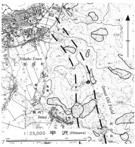
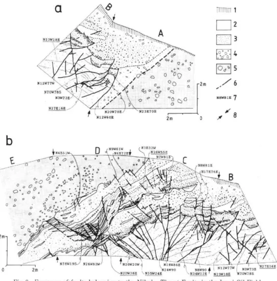
The Nikaho Thrust Faults consisting of some branching thrusts, are traceable northward along the western margin of the Yurihara Plateau. The total throw of the thrusts is immense, apparently exceeding 1,500 meters, for the heave is quite large as shown in the geologic structure around the faults (Fig. 3). Ozawa et al. (1982) mentioned that the Nikaho Faults presumably came into existence in the earliest Pliocene when the Tentokuji Formation began to be deposited. Their detailed movements of Quaternary age, however, has remained unclear because it is difficult to observe the deformed landform in this area°. This is considered to be mostly due to the existence of thick semi-consolidated sedimentary cover on the ground surfaces, especially in the inner zone of the Northeast Japan Arc. Recently, field data from an exposure in the Innai Oil Field, about 1 kilometer northeast of Innai, Nikaho Town, showing that a part of the thrust faults has slipped since the Middle Pleistocene, has been reported (Otsuki and Komatsubara, 1994 : Figs. 8 and 9). Figure 9 shows a
detailed sketch of this exposure, and their results can be summarized as follows.
At this site, it is observable that the Nishime Formation and the Yurihara Debris Avalanche Deposits crop out and the Nishime Formation is subdivided into the two units, that is, a lower and an upper unit. The lower unit is unconsolidated,
I : 25,000 (Hirasawa)
Fig. 8 Topography around faults exposure shown in Fig. 9
Modified from 1 : 25,000 topographical map "Hirasawa" of Geographical Survey tute of Japan.
broken line : main faults of the Nikaho Thrust Faults shading : landslide landform (thick line : certain thin line : uncertain) Q : exposure shown in Fig. 9
- i ,„\t-',/ -4- - - , .1,7. „tit* ,c18—• , , —
:4,v;,1•34. , ',...., ..-- .--.,:g.•:,....- ,---F ,'., . --. ,_ , ...,
. ,
A;i: -. 4,-.41r.\.7t-,•-,-.
-,--:.
, :..j!.i$5-.:zip;:ff...
,Y-
, _ * ,.1 - -;:.
.=" .''. •
\
. i
...I-Co , ..,
",
,.----
C,6),
,,,
._‘...,,,,,,..A^.( ,-,,.,)Vikaho Town ,A)
i i r— .. 31 :(-k1..44' I.,,-,, '...;07'?..t_.\4-'-1*/1,1.--.r") 1/4\ i 4 c L. , ,\..,
-‘\
i
V
k ,,, ,4
X ‘ I A , 7 ,.- ,,, , , , --....--"V LIC, • k \ .P.‘ ,:^ \ ' '. ' , t , , ',,.^ ,.,‘",.;'4, ' ', ‘ 4 . . ... , - • ,17
,<*t11.-
44:1'..
'e"
' \ .9' liA J ',, - :- 1r
'''.-
— '
5 .., , .,' ' ' j
• r,-tzi.' , 'C. \44 A .,i.. ,./c.1 k . , 1,.-,=, 4 4 - ./ , -5, •• 11,1 AV \ • >i '''' I . , '--• ' ' •• ' '''. -, ••-•' "" '- ''..; '4'4' ' '• f , . , . 44... a \ , "f it 00 , , -LE Vi ,4 ' ' * \„.,,Innoi,:'Pe*-,
*
!
,._...,- .i;--' ' ).'1. ' v '*; Ili .. t„,...- '.. :" ‘_ • -:, . / ..._ I : 25... vi,ArN., ..: '$ -,.---- .• • ,/.., 114N: t...—N,000 .41- ip,, (Hirasawa) I:)4.,,,./..,e.'12 - '---ydC\-.
.\ - '
..A u 6 ,.,
laminated, well-sorted fine to medium sandstone of marine origin, particularly of
littoral to neritic origin, as evidenced by its lithofacie. The upper unit is composed
mainly of unconsolidated pebbly fine to coarse sandstone, partly granule-bearing,
accompanied by lenticular poorly sorted silt and clay layers. From its changeable
facies, the upper unit is inferred to have been deposited under a fluvial environment.
The major fault in this exposure appears in Face A, and the Yurihara Deposits are
thrust over the Nishime Formation. The fault plane is not clear, but is presumed to
strike north 10 to 20 degrees west and dip 60 to 70 degrees east, from the trend of minor
faults in Face A. On the hanging-wall side of the major fault, there is a 50- to
100-centimeter wide fractured zone. The vertical displacement of the fault reaches a
a N23W18E N12W77W N70W785 • . N3W73E N27E16E 46) ° • " ° tir ° • N • ° .// •7;•A . 1 . • /••C7 Q o 0 .0 0 Q.° ;• n.. 0 o 00 oo -a e, 823E708 2m Trrrri 4 N20W70E 812W60E 2m a 2 3 4 Qa 5 Z 6 N8W8 lE 7 .( 8
b
N9W61Wi N1E32W if144561El•144E72E, 816855El____--.--,--5.°.0..p,.Q,..Wm_C
--6 . ,488881E•..•• N7W81 ...T.:„ -- ••••••::.817E76E 0, • ••• .4° • ° , • o 0o%...- 0.4.!t . ',c7°,..•''.'•°'••-'),;4:::•:-....--- • . .,,;;:.,' ` '4,.:"\-.1:---°:.!:::1-"-•.- a 0 0.0°'e2:•'..•..-41t..'..,'-1°....j.' ' . ' ' ' . " ':::-.-4 1 0 a e .. ' • ° • •-,-- •.-.•:., ° a . .o ,' 0 • .,,i.1,a.;4%', /:-4i.-..- :7'. 6.,)'O ° 0 ' ' ' • -: 0 ,' - " ,r--.'-'• ' . ' .. .:-... - - &ii,i'.'i a '' -...----' .., --- , ° . , , 1 . . ''.'e - . / ..-.-- : ,-, °- . .2 ,,,, . - ...A „",,%zerA‹.... • -cz,
..;;)
i. , .—Ner-4-%
-,...4,.,s-;-.A).
;,-01,...i:...:;-,-:.:.::•14k
- ,',/i,-t.,*E17.''
... •°1 N78W195 826W82W) 1/L21206120W I N18W86Ei -11 • 0 2m Nl2W N20W388,N35w248\-.N34WW12E 11N23W16 ,824W90,N890
Fig. 9 Exposure of faults belonging to the Nikaho ThrustFaultsintheInr
Nikaho Town
After Otsuki and Komatsubara (1994).
1 : weathered part (surface soil) 2: silt and clay (Nishime Formati( (Nishime Formation) 4: gravel (Nishime Formation5:Yurihara
lanche Deposits 6 : fault (broken where obscure) 7:strikeanddip01
(degree; underlined value indicates those of bedding plane)8: boundar face A-E : outcrop face (Face A-E)
Face A : N13°E45°W Face B : N54°E45°NW Face C: N72°E45°N N57°E45°NW Face E : N42°E45°NW
.N3N4W8W92EN23W18E FaultsintheInna 817E76E B 0•-.°• 90N"W"w N3W73E 527E15E 12EN23W18EN70W785
intheInnai Oil Field,
ishime Formation) 3: sand ) 5 : Yurihara Debris Ava-strike and dip of fault plane .ne) 8 : boundary of outcrop
Face D :
light of the surrounding geologic features. In Facies A to C, numerous minor reverse
faults which are the same trend as or conjugated to the major fault are discernible, and some minor normal faults are present in Facies C to D and are considered to reflect the
local tensional stress field on the hanging-wall. All of the minor faults accompanies
the movement of the major fault. At least three types of these minor faults, which
deform only the lower unit of the Nishime Formation, the lower and upper units of the
formation, or only the Yurihara Deposits, respectively, are present in Facies A to E.
This fact results from the presence of interrupted sedimentation after the appearances
of the faults in each unit or in the deposits, and it is thus concluded that the major fault has slipped three times at least since the middle period of the Middle Pleistocene.
From these results, it is inferred that the Nikaho Thrust Faults, at least a part of them, continued to be active after late Middle Pleistocene time. In contrast, the Nishime Syncline is confirmed to have deformed the Nishime Formation and the underlying rocks. The recent tectonic trend around the Nishime Basin since the Late Pleistocene is described in the next chapter, on the basis of the distribution of the geomorphic surfaces.
5. Geomorphic surfaces in the Nishime Basin : Relation to recent tectonic trend of the sedimentary basin
Along the Koyoshigawa River, flowing from the northeastern foot of the Chokai Volcano into the Japan Sea at Honjo City, several fluvial terrace surfaces of Middle Pleistocene to Holocene age are distributed. All of these surfaces are thought to have been formed after the deposition of the Yurihara Debris Avalanche around the Koyoshigawa River Valley (Ozawa et al., 1977, 1988). On the other hand, no remark-able Pleistocene terrace surface can be recognized near the Nishimegawa River, except for Hj-M1 surface which fragmentarily exists only on the boundary between the Nishimegawa and Koyoshigawa River Basins (Fig. 3), in relation to the quite small catchment area of the Nishimegawa River.
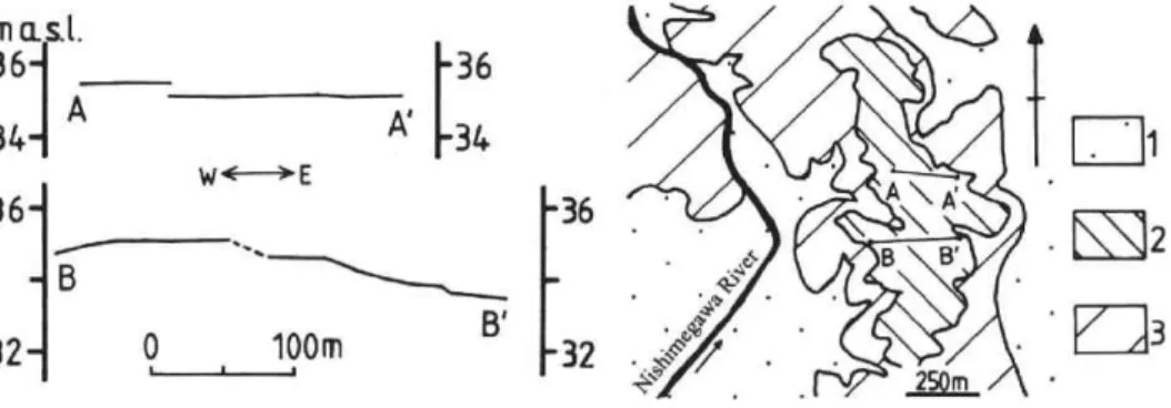
Hj-M1 Terrace Surface, which has an approximate altitude of 35 meters and is of fluvial origin as already stated, is inferred to have been formed in the lowest course of the river, that is, it is regarded as a thalassostatic terrace surface in the Last Interg-lacial Stage, in consideration of its altitudinal distribution, locality, and the lithofacies of the terrace deposit. Because this surface is situated on the eastern limb of the Nishime Syncline, it is possible to evaluate the synclinal activity since the Late Pleistocene from the shape of the surface. As shown in Fig. 10, no westward tilting is discernible in the topographic profiles of Hj-Ml Surface, and from this it is inferred that there has been no folding of the Nishime Syncline since the Last Interglacial5).
In the study area, no higher terrace surfaces are currently observable because the Yurihara Debris Avalanche Deposits widely predominate ; the distribution and the geologic structure of the Nishime Formation, however, suggest that the buried or
m a.s.t. • ^
361
A_
36NI.).
•
' [34
111.
r. -
34 A136
36
70, i4F4.:;›
. ISE12
• 4,,,5"ce • -B'
.
i13
0 100m•32411C‘
047•• zgm_Fig. 10 Topographic profiles on Hj-M1 Terrace Surface at Funaoka, Honjo City, in the north of the study area
(legends of geomorphological map) 1 : Holocene surfaces and sand dune 2 : Hj-M1 Surface 3 : terrace scarp and hill slope
denuded depositional surface of the formation has a relative height of several tens of
meters above the Holocene surfaces in the basin (Fig. 3). In consideration of the
presence of the higher terrace which was formed prior to the Last Interglacial
Maximum time, mainly in the Middle Pleistocene, and which can be regarded as an
indication of uplifting from the terrace-emerging age up to present (Otsuki, 1991,
1999a), the whole area of the Nishime Basin is dominated by a regional uplift at
present, although a small-scale alluvial lowland exists along the Nishimegawa River.
The facts that the upper part of the Nishime Formation is thought to have been
deposited near the river mouth as indicated by its lithofacies and that it constitutes the
basal part of the hill in the basin (Yurihara Plateau), also support this view. The
cease of the folding and the present dominance by the regional uplift are consistent
with the present morphology of Hj-M1 Terrace Surface which is nearly horizontal.
6. Latest Cenozoic tectonics of the Nishime Sedimentary Basin
The Nishime Basin accompanying the Nishime Syncline came into existence when the Nikaho Thrust Faults and the Yashima Anticlinorium which restrict both western and eastern margins of the basin, respectively, began to move in the earliest Pliocene (Ozawa et al., 1982). Then the basin continued to subside relatively and to be filled with the Tentokuji and Sasaoka Formations, whereas the whole of the Dewa Hills, including the basin, were uplifted because both formations regionally show an upward increase in grain size and a decrease in water depth.
Probably until the middle of the Middle Pleistocene, the Nishime Formation of neritic and fluvial origins was deposited in the basin. In the western part of the basin, the deposition of the formation unconformably covering the Sasaoka Formation is inferred to have been confined by the hill which emerged above the sea level in part of
Japan
Sea
Nishimegawa River Fig 3. t
;14 =" o=a
I(I
= E." • • • •I
a g a 03 CI Cn Wi • . ^.; <-• • 77. 6II
I I t
'
I 17=i
-OA 5
ri Kiromorigawa\1\ River
Nishime Syncline Chokai Volcano 5 kmI
Yashima Anticlinorium vo I^1 . ° o04
Fig. 11 Distribution of Late Miocene intrusive, partly eruptive, rock bodies of hornblende (-biotite) rhyolite around the Nishime Sedimentary Basin
shading : rock bodies of rhyolite, after Nakano and Tsuchiya (1992) and Ozawa et al. (1977, 1979a, b, 1982, 1988)
the western flank of the syncline, as indicated by the geologic structure.
In the Nishime Basin, the pebbly sandstone and conglomerate in the upper part of the Nishime Formation contain clasts of andesite, siliceous mudstone originating in the Onnagawa Formation, and hornblende (-biotite) rhyolite of Late Miocene age, and are similar to the present Koyoshigawa River bed deposit in clast composition. In particular, grayish white hornblende (-biotite) rhyolite crops out on the east and south of the Chokai Volcano (e.g. Nakano and Tsuchiya, 1992 ; Ozawa et al., 1979b) around the study area (Fig. 11). In consideration of the absence of the present Koyoshigawa River Valley in the age when the Nishime Formation was deposited as already mentioned, the sediments of the upper Nishime Formation in the basin are inferred to have been directly supplied by the ancient Koyoshigawa River from the south, prob-ably along the Nishime synclinal axis.
In the study area, the Yurihara Debris Avalanche then flowed down the Chokai Volcano and was deposited in the middle to late Middle Pleistocene, and some terrace surfaces were formed in the late Middle to Late Pleistocene. The Nishime Syncline, however, has not moved since the Late Pleistocene, as shown by the topographic profiles of Hj-M1 Surface. The folding in the area came to an end after the deposition of the Nishime Formation before the formation of Hj-M1 Surface, that is, in the middle to late Middle Pleistocene. The synclinal activity is presumed to have decayed before the deposition of the Yurihara Debris Avalanche, because the Yurihara Debris Avalanche Deposits buried an elongated depression on the Nishime Formation (Itaga-ki, 1992) and it is currently difficult to recognize any significant deformation on the depositional surface of the Yurihara Debris Avalanche accompanying folding. Subse-quently, the whole area around the Nishime Basin has been dominated by only the tendency of regional uplifting (Fig. 12). Similar phenomena of sedimentary basins disappearing or declining in the Middle Pleistocene are recognizable in the Dewa Hills, for example, the Takanosu Basin, Wada Basin, and so on (e.g. Otsuki, 1991, 1995a, b ; Fig. 1). Along the Omonogawa River (Fig. 2), one of the antecedent rivers flowing across the Dewa Hills and into the Japan Sea at Akita City, the accumulation of the basin-fills in the Wada Basin ceased in middle Middle Pleistocene time, and the whole of the Dewa Hills has been uplifted in an east-west width of 30 to 40 kilometers since that age (e.g. Otsuki, 1994, 1999b). These results are in accordance with the case of the Nishime Basin.
On the other hand, the Nikaho Thrust Faults, which partly promoted the growth of the Nishime Syncline, are confirmed to have been active after the Yurihara Debris Avalanche Deposits were laid down in the study area. In the some areas along the Japan Sea coast, the geologic and geomorphic features have been clarified, showing the movement since the Late Pleistocene of the faults belonging to the Kitayuri Thrust Fault System which restricts the western margin of the Dewa Hills (e.g. Awata and
Stratigraphy & Structures
of the Nishime Basin
Succession
of the Nishime Basin Dewa Hills
(Present) 1.4 Pliocene Late Miocene Hj-M2 S, 0.13 Hj-Ml S. 0.73 (urihara Debris Avalanche Ds. Nishime F. 1.64 5.1 (Ma) Fig. Sasaoka F. Tentokuji F. Funakawa F. .F., c.n cid w. tr„ z F. Formation Regional uplifting trend only - - - (disappearance) Nishime Syncline accompanied sedimentary basin. —1-- (initiation) S. Surface Ds. Deposits z 0 -a
12 Latest Cenozoic succession of the Nishime Sedimentary Basin
t' o
i
s.. ` 24 .2 2Kakimi, 1985 ; Komatsubara, 1997). In particular, the uplift amount and rate of the
Dewa Hills increase westward and have reached a maximum close to the thrust fault
system since then along the antecedent rivers (Otsuki, 1994, 1999b). From these facts,
it is inferred that the Nikaho Thrust Faults have also continued to move since the Late
Pleistocene up to present in no connection with the Nishime Syncline, although it is
difficult to identify any evident deformed landform along the faults.
7. Conclusion
The Nishime Sedimentary Basin continued to exist as a relative subsided area accompanying the movement of the Nishime Syncline from the earliest Pliocene, and finished being filled with a sequence of basin-fills prior to the deposition of the Yurihara Debris Avalanche in the middle to late period of Middle Pleistocene age, on account of the extinction of the syncline. Subsequently, only the regional uplift has predominated in the whole of the Nishime Basin up to present, and the basin is no longer an active sedimentary basin. The Nikaho Thrust Faults situated on the
western fringe of the basin, however, have continued to moved since earliest Pliocene time.
From the case of the Nishime Sedimentary Basin and some information on the other basins in the Dewa Hills, it is concluded that both the uplifted and subsided areas were concurrent from the early Pliocene to the Middle Pleistocene in the Dewa Hills. In contrast, the hills are considered to have grown until present as a single uplift zone restricted at its western margin by the Kitayuri Thrust Fault System. Regarding these points, further detailed geological and geomorphological studies on the other areas in the Dewa Hills are necessary.
Acknowledgements
I would like to express my grateful appreciation to Dr. Taku Komatsubara,
Geological Survey of Japan, for valuable discussions on this subject. I am also much
indebted to Professor Toshikazu Tamura, Institute of Geography, Tohoku University,
for many suggestions during the course of this work. I wish to acknowledge the kind
support of Mr. Shuichiro Hori, Honjo Seismological Observatory, Research Center for
Prediction of Earthquakes and Volcanic Eruptions, Tohoku University, during the
fieldwork. Sincere thanks are extended to Mr. Akihiko Sasaki, graduate student of
the Institute of Geography, Tohoku University, who provided helpful assistance in the field.
Notes
1) The Kitayuri Thrust Fault System comprises the Noshiro Thrust Faults (Ozawa at al., 1983), the Kitayuri Thrust Faults (Huzioka et al., 1977), the Nikaho Thrust Faults (Ozawa
et al., 1982), and the Sakata Thrust Faults (Ikebe at al., 1979) from north to south,
according to Ozawa at al. (1984).
2) Description of Hj-M2 Terrace Deposit, the landslide detritus, and the Holocene deposits is omitted because of little exposure of these deposits.
3) In this paper, "the older deposits" correspond to the debris avalanche deposits distributed around the Chokai Volcano, except for the Kisakata Debris Avalanche Deposits of about
2.6 to 3.0 ka (e.g. Ozawa at al., 1982, 1988).
4) For example, the Research Group for Active Faults of Japan (1991) did not regard the Nikaho Thrust Faults, particularly their main faults, as definite active faults.
5) Near Hj-M1 Terrace, the Sasaoka Formation dips at least 8 degrees west (Fig. 3). If it is assumed that this tilting has continued to occur with steady-state during the last 2
million years, Hj-M1 Surface of about 130 ka is expected to dip more than 9 per mil west
at present.
References (*in Japanese, **in Japanese with English abstract)
Awata, Y. and Kakimi, T. (1985) : Quaternary tectonics and damaging earthquakes in northeast Honshu. Earthq. Predict. Res., 3, 231-251.
Ban, M., Hayashi, S., and Takaoka, N. (1989) : K-Ar dating of Chokai volcano, northeast Japan.* Bull. Volcanol. Soc. Japan, 2nd ser., 34, 332.
Hayashi, S. (1984) : Geology of Chokai volcano.** Jour. Japan Assoc. Min. Petrol. Econ. Geol., 79, 249-265.
Hayashi, S. (1985) : Petrology of Chokai volcano, Northeastern Japan. Sci. Rep. Tohoku Univ., 3rd ser. (Min. Petrol. Econ. Geol.), 16, 269-325.
Huzioka, K., Ozawa, A., and Ikebe, Y. (1976) : Geology of the Ugo-Wada district.** gle Series scale 1 : 50,000, Geol. Surv. Japan.
Ikebe, Y., Ozawa, A., and Inoue, H. (1979) : Geology of the Sakata district.** Quadrangle Series scale 1 : 50,000, Geol. Surv. Japan.
Itagaki, N. (1992) : Debris avalanche deposits distributed in the Yurihara Plateau, northern foot of Chokai Volcano.* Quarterly Journal of Geography, 44, 63-64.
Kaizuka, S. and Imaizumi, T. (1984) : Horizontal strain rates of the Japanese islands estimated from Quaternary fault data. Geogr. Rep. Tokyo Metropol. Univ., 19, 43-65.
Kutsuzawa, A. and Kim, C. (1966) : On structural analysis of the Toridame Fault. Jour. Min. Coll. Akita Univ., Ser. A, 4, 35-51.
Komatsubara, T. (1997) : Upper Quaternary geology and structural evolution of the eastern part of the Shonai Sedimentary Basin.** Bull. Geol. Surv. Japan, 48, 537-565.
Mitsuchi, T. (1938) : The geology of the Nikabo Oil Field, Akita Prefecture (with topographical and geological map).* Explanatory text of the oil fields of the Japanese Empire, section
XXXIII. Imp. Geol. Surv. Japan.
Nakano, S. and Tsuchiya, N. (1992) : Geology of the ChOkaisan and Fukura district.** rangle Series scale 1 : 50,000, Geol. Surv. Japan.
Omura, I. (1928) : Outline of petroleum geology (18).* Chikyu (Earth), 9, 303-310.
Otsuki, Y. (1991) : The Middle Pleistocene basin-fills and higher terraces in the Takanosu Basin, Northeastern Japan.** Journal of Geography, 100, 1077-1091.
Otsuki, Y. (1994) : Middle-Late Quaternary activity of the Kitayuri Thrust Fault system and crustal movement of the Dewa Hills, inner belt of the Northeast Japan Arc.*
ings of the General Meeting of the Association of Japanese Geographers, 45, 208-209. Otsuki, Y. (1995a) : Quaternary geology of the Wada Basin and uplift process of the Dewa Hills,
Northeast Japan.* Abstracts of the 102nd Annual Meeting of the Geological Society of
Japan, 118.
Otsuki, Y. (1995b) : Uplifting process of the Dewa Hills in the inner zone of the Northeast Japan Arc.* Programme and Abstracts of Japan Association for Quaternary Research, 25, 105.
Otsuki, Y. (1999a) : Geologic structures and boundary faults along the western margin of the Odate Basin, Northeast Japan. Sci. Rep. Tohoku Univ., 7th ser. (Geogr.), 49, 37-54. Otsuki, Y. (1999b) : Latest Cenozoic tectonic processes of mountain ranges and sedimentary
basins in the Northeast Japan Arc. Proceedings of Korea-Japan/Japan-Korea
phological Conference, 141-144.
Otsuki, Y. and Komatsubara, T. (1994) : Data on the Quaternary movement of the Nikaho Thrust Faults along the Japan Sea coast, Northeast Japan.* Active Fault Research, 12,
24-29.
Quadrangle Series scale 1 : 50,000, Geol. Surv. Japan.
Ozawa, A., Ohguchi, T., and Takayasu, T. (1979a) : Geology of the Yuzawa district.** rangle Series scale 1 : 50,000, Geol. Surv. Japan.
Ozawa, A., Ohguchi, T., and Takayasu, T. (1979b): Geology of the Asamai district.** rangle Series scale 1 : 50,000, Geol. Surv. Japan.
Ozawa, A., Ikebe, Y., Arakawa, Y., Tsuchiya, N., Satoh, H., and Kakimi, T. (1982) : Geology of the Kisakata district (including Tobishima in the Sakata district).** Quadrangle
Series scale 1 : 50,000, Geol. Surv. Japan.
Ozawa, A., Tsuchiya, N., and Sumi, K. (1983) : Geology of the Nakahama district.** gle Series scale 1 : 50,000, Geol. Surv. Japan,
Ozawa, A., Ikebe, Y., Hirayama, J., Awata, Y., and Takayasu, T. (1984) : Geology of the Noshiro district.** Quadrangle Series scale 1 : 50,000, Geol. Surv. Japan.
Ozawa, A., Katahira, T., Nakano, S., Tsuchiya, N., and Awata, Y. (1988) : Geology of the Yashima district.** Quadrangle Series scale 1 : 50,000, Geol. Surv. Japan.
Sato, H. (1989) : Degree of deformation of late Cenozoic strata in the Northeast Honshu Arc.** Mem. Soc. Geol. Japan, 32, 257-268.
Sato, T., Takayama, T., Kato, M., and Kudo, T. (1988) : Calcareous microfossil biostratigraphy
of the uppermost Cenozoic formations distributed in the coast of the Japan Sea —Part 3 : Akita Area and Oga Peninsula—. * * Jour. Japan. Assoc. Petroleum Tech., 53, 212.
Suzuki, K. and Nasu, T. (1988) : Plant biostratigraphy of the Plio-Pleistocene series in Japan.** Mem. Soc. Geol. Japan, 30, 169-180.
The Research Group for Active Faults of Japan ed. (1991) : Active faults in Japan—Sheet mats and inventories (revised edition)—.** University of Tokyo Press, Tokyo, Japan. The Tohoku Regional Agricultural Administration Bureau (1982) : Hydrogeological maps of
Aomori and Akita Prefectures : Investigation report on ground water for agriculture in Aomori and Akita Prefectures.* The Tohoku Regional Agricultural Administration
Bureau, Ministry of Agriculture, Forestry and Fisheries, Sendai, Japan.