CITATION
Eriksen, C.C., and M.J. Perry. 2009. The nurturing of seagliders by the National Oceanographic Partnership Program. Oceanography 22(2):146–157, doi:10.5670/oceanog.2009.45.
COPYRIGHT
This article has been published in Oceanography, Volume 22, Number 2, a quarterly journal of The Oceanography Society. Copyright 2009 by The Oceanography Society. All rights reserved.
USAGE
Permission is granted to copy this article for use in teaching and research. Republication, systematic reproduction, or collective redistribution of any portion of this article by photocopy machine, reposting, or other means is permitted only with the approval of The Oceanography Society. Send all correspondence to: [email protected] or The Oceanography Society, PO Box 1931, Rockville, MD 20849-1931, USA.
OceanographyTHE OffICIAl MAGAzINE Of THE OCEANOGRAPHY SOCIETY
DOwNlOADED fROM www.TOS.ORG/OCEANOGRAPHY
Nurturing The
of Seagliders
by the National Oceanographic Partnership Program
B y C h a r l e S C . e r i k S e N a N d M a r y J a N e P e r r y B y C h a r l e S C . e r i k S e N a N d M a r y J a N e P e r r y
N O P P S P e C i a l i S S U e » O C e a N O B S e r V i N g P l at f O r M S a N d S e N S O r S N O P P S P e C i a l i S S U e » O C e a N O B S e r V i N g P l at f O r M S a N d S e N S O r S
tool for biological, optical, and chemical studies of the ocean.
Industrial partners for the NOPP Seaglider project were Western Environmental Technologies Laboratories Inc. (WET Labs) and Sea-Bird Electronics Inc.; govern- ment partners were the Washington Department of Ecology and the King County Department of Natural Resources; and academic partners were University of Washington (UW), University of Maine, and Oregon State University. The industrial partners developed and provided custom sensors for Seagliders, variants of which are now in wide use on other gliders and floats, thanks to their low power, small size, and hydrodynamically unobtrusive design.
NOPP supported the transition from cellular to satellite communication for data telemetry, through the bankruptcy of satellite providers and re-emergence of the industry with government contracts. The project developed the first submersible dual-use GPS/Iridium
antenna, enabling Seagliders to venture globally. Thanks to Iridium’s high speed and low cost, just two Seagliders at sea are able to return more data bytes daily, and at a tiny fraction of the cost per byte, than the entire Argo network of
~ 3000 profiling floats, which rely on the venerable Argos system.
NOPP-sponsored developments have brought sufficient technological maturation that Seagliders have become prodigious autonomous workhorses. A partial list of their uses includes making nearly continuous repeat sections across the boundary currents over the Washington continental slope for over five years to date, crisscrossing the Labrador Sea over all seasons, traversing the Kuroshio undisturbed by the passage of a typhoon, surveying eddies in the Gulf of Alaska, repeatedly surveying the Hawaii Ocean Time-series site, monitoring flows across the Iceland- Scotland Ridge, and following floats to observe the North Atlantic spring bloom. Outside academia, Seagliders have participated in several US Navy exercises. Demand has led to licensing this technology commercially. Thanks to the initial developments under NOPP, Seaglider technology is being extended to include work under ice, excursions to the bottom of the open deep ocean, and individual missions lasting over a year and running continuously.
iNtrOdUCtiON
The development of Seagliders as economical long-range autonomous plat- forms for interdisciplinary ocean obser- vations was initially supported through a National Oceanographic Partnership Program (NOPP) grant in 1999. NOPP sponsored the addition of chemical and biological sensing capability, integration of satellite communications, software development, and generally increasing the performance and reliability of Seagliders. The first Seaglider had yet to undertake an overnight mission when the NOPP proposal was submitted.
By the time the NOPP funding was complete, Seagliders had amassed several years of at-sea experience in the open ocean, had set and reset the range and endurance records for all autonomous underwater vehicles (AUVs), had been replicated over 40 times, and were being furnished to and operated by various academic groups and the US Navy.
What started as a platform for physical measurements has become an accepted
aBStr aCt. The National Oceanographic Partnership Program provided critical support to the development of Seaglider long-range autonomous underwater vehicles.
This support enabled: (1) development and integration of chemical and biological sensors, (2) transition to low-power, bi-directional satellite communication, and (3) software upgrades to enhance capability and reliability. Sponsored improvements led to setting the mission endurance and range records for autonomous
underwater vehicles, wide use by the oceanographic community, and licensing for commercialization.
the NOPP rOle
Most of what we know about the ocean historically has come from ship-based observations, and as all oceanographers know, ship time is a prized asset. We are always sad when we hear of a ship being laid up or having its schedule curtailed.
We prefer not to see oceanographic ships in port, because that means they are not out gathering precious observa- tions. Until about half a century ago, lowering an instrument over the side of a ship was the only practical means of observing the ocean’s internal structure.
Serendipitously, the need to predict storms led to stationing weather ships at a few remote at-sea locations for months at a time, thus providing an opportunity to repeatedly sample the sea using the same method in various locations. Over the last few decades, oceanographers learned to extend a ship’s footprint in time by setting moorings to collect time series. Weather ships were retired when satellites obviated their need, and early promoters of ocean satellite observations teased that the alternative to satellite oceanography was an endless grid of moorings. Seawater being electromag- netically opaque ensured the continued need for moorings to observe the ocean interior through time, and for ships to both service moorings and to perform their customary surveys. None of these techniques is particularly thrifty, and one can argue that expensive access to the sea
is the principal impediment to observing and ultimately understanding the ocean.
Motivated by such problems, ocean- ographers began in recent decades to develop autonomous and Lagrangian platforms and sensors. John Swallow is widely credited with recognizing the existence of mesoscale eddies from his pioneering Sargasso Sea float measure- ments in the 1960s. Subsequent devel- opments led to broad use of related technologies, one great strength of which is the ability to establish distributed arrays of observing elements (Rudnick and Perry, 2003), something that can rarely be done with ships (“Overflow 1960,” a nine-ship survey of the Iceland- Faroe Ridge is one of few examples; Tait, 1967). Today, over 3,000 profiling floats are distributed about the world ocean in the Argo program (see Roemmich, this issue), providing critical data on large-scale ocean properties and their responses to climate change. But, even at close to two orders of magnitude more platforms than there are research vessels, Argo floats are widely separated compared to what is requisite to resolve the smaller scales (i.e., eddies, fronts, filaments, and boundary currents that a turbulent ocean promulgates).
Enter gliders, the champion autono- mous underwater vehicles in range and endurance. These little robots are the closest we have to inexpensive ships, platforms that can be directed to sample the ocean interior remotely. Thomas Curtin, while a program manager at the US Office of Naval Research (ONR), had the vision to establish a program to develop Autonomous Oceanographic Sampling Networks (AOSN) under the auspices of a Department of Defense Multidisciplinary University Research
Initiative. About a quarter of the AOSN budget was devoted to glider develop- ment, giving birth to three distinct models, now known as Slocum, Spray, and Seaglider (Davis et al., 2002). As with all technologies, gliders have their own limitations (see Rudnick et al., 2004). This article focuses on the story of Seagliders (Figure 1) and the significant role NOPP played in their development.
In 1999, NOPP program officials had the foresight to issue a Broad Agency Announcement for “Ocean Observation Capabilities.” Among the elements it called for were “to develop and demon- strate ocean observational capabilities to establish the means for continuous high resolution measurements of oceanic processes,” “for development and application of new sampling…
Charles C. Eriksen ([email protected].
edu) is Professor, School of Oceanography, University of Washington, Seattle, WA, USA. Mary Jane Perry (perrymj@maine.
edu) is Professor, School of Marine Sciences, Darling Marine Center, University of Maine, Walpole, ME, USA.
figure 1. Seaglider S/N 005 at the sea surface in Port Susan, Washington, during checkout for an open ocean deployment. This single vehicle has operated in the open ocean for 888 days to date in 10 missions covering more than 16,000 km through the water.
techniques to improve the characteriza- tion of distributions, mechanisms, and rates of processes involving chemical and biological variables together with phys- ical variables in the ocean,” “to develop
‘smart’ sampling tools based on real-time measurements” that offer “autonomous,”
“long-term,” and “distributed approaches that provide a new observational capability for the ocean community,”
and that use “innovative sensors and measurement techniques to obtain oceanographic variables (chemical, optical, biological) in 3-D space and time to augment physical variables.” Emphasis was to be placed on “developing the next generation of low cost instrumentation usable by the ocean research commu- nity.” Our response claimed brazenly that “work proposed here does all of this and more.” Luckily, we had help in proposal preparation from a former ONR program manager (and recall that he inserted that audacious claim).
The review panel expressed confi- dence in the proposed sensor suite, but had concerns about the platform. They worried whether the glider would “be best considered a drifter with a control- lable bias instead of a ‘free swimmer’…
Does the unattended glider pose a hazard to fishing gear? To boats and ships?”
After only two decades worth of days at sea and tracks through the ocean totaling but more than thrice Earth’s circumfer- ence, we can declare that Seagliders are robust surveyors of the ocean and not obvious hazards to navigation. It even may be argued that gliders assist naviga- tion, which, after all, is the source of much of the military interest in them.
We know of no case where a Seaglider has damaged a vessel or gear, but of a few where a Seaglider has been damaged
by a surface vessel and one where a Seaglider found by fishermen in an outrigger canoe was bartered back with frozen meat and ice cream (Craig Lee, University of Washington, pers. comm., 2008). Fortunately, Seagliders’ exposure on the sea surface is typically a percent
or two of their time at sea. Despite the reservations of the review panel, the NOPP program officers thought the work proposed deserved high priority and “would have profound impact on the conduct of ocean science research.”
Specifically, NOPP granted support to extend development of Seagliders by adding dissolved oxygen and bio-optical instrumentation to what was at the time a platform for measuring temperature and salinity. In fact, when we submitted our proposal, experience with the Virtual Mooring Glider (as we were calling it then) was limited to a handful of dives in Puget Sound within Seattle city limits.
We had barely learned to steer it (the vehicles turn opposite to the direction the wings are rolled while diving, but in the same direction while climbing, a consequence of wings mounted far aft of the center of buoyancy). The Virtual Mooring Glider (named for how we envisioned a glider would be most useful) was hardly a functioning useful platform in early 1999, but it had navi- gated itself for eight days across a fjord
within Puget Sound, called Port Susan, just three days before the NOPP award was issued, confirming our confidence in this rapidly evolving technology.
The awkward original name was changed to the more descriptive Seaglider while the NOPP proposal
was under consideration. In fact, while Seagliders have “held station” better than the watch circle of a surface mooring buoy, the survey mode has proven more powerful in providing a joint space-time description of oceanic features and processes. Alas, the name has become generic, just as Kleenex and Xerox entered the lexicon, but for a different reason: Seagliders do what the name suggests (rather than ever having held a monopoly). An article in a prominent newsweekly recently described the similar vehicles Slocum and Spray as “sea gliders,” although it omitted mention of Seagliders (The Economist, 2008).
NOPP support played a critical role in continuing Seaglider development, and it is to NOPP that the technology owes much of its success. As UW ocean engineer Jim Osse remarked, Seaglider is the first of his creations ever to be more than a “one-off.” To date, over 90 Seagliders have been built, and the technology was recently licensed for commercial production.
“ ”
What Started aS a PlatfOrM fOr PhySiCal MeaSUreMeNtS haS BeCOMe aN aCCePted tOOl fOr BiOlOgiCal, OPtiCal, aNd CheMiCal StUdieS Of the OCeaN.
Seaglider fUNdaMeNtalS Underwater gliders use self-controlled buoyancy to alternately sink and rise while converting a portion of the gravita- tional motive force to horizontal motion using wings. Wings are their propellers, holding them up and giving a forward push as they descend and conversely holding them down while pushing forward as they climb. Unlike sail-planes in the atmosphere, underwater gliders make themselves buoyant at the bottom of a dive in order to glide as they climb back to the sea surface. Seaglider and its relatives Slocum and Spray are designed to glide along steeply sloped paths as opposed to the gentle glide paths of high-performance aeronautical gliders.
Rather than simply trying to go as far as possible horizontally before landing as aeronautical gliders do, the dual objec- tives of an oceanographic glider are to both profile and change location. The
relatively steep glide path of Seaglider (in the range 1:1 to 1:5) is by design much steeper than the typical slope of naturally occurring property surfaces within the ocean on scales that are large compared to Seaglider dimensions.
Long range and endurance as well as effective navigation are achieved by trav- eling only somewhat faster than ocean currents. Propulsive energy provided
by buoyancy is ultimately dissipated through hydrodynamic drag. Because drag typically varies quadratically with speed, mission range and endurance for a fixed energy supply vary inversely with speed and its square, respectively.
(Seaglider’s hull drag is proportional to [speed]3/2, implying mission range and endurance are proportional to [speed]-1/2 and [speed]-3/2, respectively.) The prac- tical lower limit to speed and upper limit to range is the average current speed over the depth range of a dive-climb cycle. A glider encountering a swifter average current than its own speed cannot navigate to arbitrary locations, though it may effectively operate in a downstream survey mode.
Seagliders operate completely autono- mously during each dive cycle while descending as deep as 1-km depth. From a Global Positioning System (GPS) fix and an onboard file of targets, a glider
chooses a glide slope and a compass heading along which to dead reckon underwater. Vehicle pitch and heading are controlled by moving the battery pack fore/aft or rotating it to tilt the wings. Typical turn radii are about 30 m.
Seagliders collect measurements during both the dive and climb phases of the dive cycle at temporal rates determined by a file of depth ranges. When the glider
reaches its target depth (as determined by a map or an acoustic range from the bottom), it pitches from pointing below to above horizontal and pumps oil from a reservoir inside the pressure hull to an external swim bladder. Inflating the bladder increases vehicle volume displacement to make the glider buoyant so that it climbs to the sea surface. Once there, it transmits all data from the dive cycle (and any files previously unsent) to a base station computer (typically ashore) and receives any control files resident there. After a few minutes communicating, another dive cycle starts, lasting from a fraction of an hour to a fraction of a day.
Lithium primary batteries power Seagliders. The 17 megajoules on board the most advanced models are enough to power them for nearly a year in lightly stratified regions. Stronger stratification and swift currents both require higher rates of energy consumption. “Half a knot on half a watt” is not far from reality, although, just as with any vehicle,
“your mileage may vary.”
The original Virtual Mooring Glider recorded only temperature and seawater electrical conductivity (from which salinity and density can be calculated).
Thanks to industrial partners included in the NOPP support, sensors to detect dissolved oxygen, chlorophyll fluores- cence, and optical backscatter were added. Battery consumption is limited by the duty cycle for the onboard processor and instrumentation. Even near the surface, for a majority of time, only the trickle of current necessary to maintain the processor in low-power sleep is consumed. At depth, where sampling rates are typically lower, the computer and sensors are on for
“ ”
NOPP-SPONSOred deVelOPMeNtS haVe BrOUght SUffiCieNt teChNOlOgiCal MatUratiON that Sea- gliderS haVe BeCOMe PrOdigiOUS aUtONOMOUS WOrkhOrSeS.
only a few seconds of every minute.
Average vertical speeds can be as low as 0.05 m s-1, so vertical resolution can be as fine as 3 m even when samples are taken only every minute.
It is by design that all three AOSN- sponsored gliders are similarly diminu- tive (~ 50-kg mass). They are light enough to be handled manually by two persons without need for power-assist equipment to launch and recover at sea.
Small size economizes both fabrication and operation, two properties favor- able to their use in distributed ocean observing arrays.
the COMMUNiCatiONS Saga Underwater gliders became practical to develop once several key technologies external to oceanography became avail- able. The constellation of GPS satellites necessary for glider navigation was operational, and lithium batteries had become relatively safe a decade prior to Seaglider development, but low-power, globally remote, two-way communica- tion has only become a reality this decade. Seagliders used cellular tele- phone modems to relay commands and data until the Iridium system rose from bankruptcy and found a niche market of providing communications from remote locations. Our NOPP grant through the US National Science Foundation (NSF) and additional support from ONR enabled the transition to satellite, hence global, communications.
Until the advent of low-Earth-orbit satellite communications, oceanogra- phers had to rely on Système Argos to return data from sea at the still pain- fully low rate of a couple of hundred bytes per day and were unable to send commands to platforms at sea.
Motorola Corporation developed the Iridium system for roughly $7 billion and launched the service in November 1998, charging about $3,000 for a hand set and $6 per minute for connect time.
Data service was promised quarter after quarter, but bankruptcy was declared in August 1999. Fortunately, our NOPP project was predicated on using cellular phone service in the inland waters of western Washington, Puget Sound.
Iridium prepared plans in April 2000 to de-orbit its constellation of 88 satellites after failing to sell the system. (Radio astronomers were delighted, since Iridium operates in the same frequency band as the univer- sally abundant hydroxyl radical.) After bankruptcy court cancelled debt claims, the assets were purchased for a mere
$25 million by a group of investors. The new Iridium quickly obtained a contract to provide 20,000 phones to US govern- ment personnel that paid half their oper- ating costs. Most significant to oceanog- raphers, they turned on the long-awaited data service in June 2001.
In an era when terrestrial data transfer rates are measured in millions of bytes per second, Iridium’s maximum throughput rate of ~ 200 bytes per second is slow. However, it represents a speed improvement of roughly 100,000 over that available to oceanographers through Argos. Moreover, two-way communication is now practical so that platforms can be remotely controlled well over the horizon. Thanks to mobile Internet connectivity, we have controlled Seagliders from a laptop in the passenger seat of a moving automobile, among other locations. The standard Argos charge amounts to about $40 per kilo- byte, whereas Iridium data transfer
costs only a dime or two per kilobyte.
The equally important energy cost amounts to 20–50 joules per kilobyte, low enough that data transfer requires a couple of kilojoules and a few dollars per Seaglider dive cycle.
Once we read in the newspaper that US special forces soldiers were calling in airstrikes in Afghanistan from horseback using Iridium, we were confident that Iridium would be around long enough to be of use to Seagliders. Implementation of Iridium telemetry required both a modem and an antenna, neither of which were readily available when data service was offered. The modem break- through came when Clayton Jones of Webb Research Corporation managed to obtain instructions from Motorola on how to convert an Iridium handset into a data modem (hitherto proprietary infor- mation) and dashed the “tuned cavity”
myth that one provider promulgated about the unsuitably hefty phone casing.
A submersible antenna that would not add unduly to vehicle drag had to be developed. We searched the UW course catalog for a professor who taught a graduate course on antenna design to find our colleague Yasuo Kuga. He cheer- fully designed a helical antenna wrapped around a syntactic foam core tuned to take account of the potting compound dielectric properties. The antenna reso- nates at a frequency between the Iridium and GPS frequencies (conveniently separated by only 2–3%), so that a single element is used for both communication and navigation. The antenna, its coaxial feed, and support require no more buoyancy to raise a meter above the sea surface than is typical for Seaglider propulsion. This circumstance means the energy cost of antenna exposure typically
is simply the small amount required to pitch the vehicle nose down by moving the battery pack forward, obviating the need to gain more buoyancy from the pumping system.
BiO-OPtiCal SeNSOrS
Seaglider began its life as a tool for phys- ical oceanography. The NOPP challenge was to broaden its measurement capa- bilities to include properties of interest to biologists, chemists, and environmental managers. Two optical properties of great interest to both the biological and optical communities were chlorophyll a fluorescence and optical backscatter;
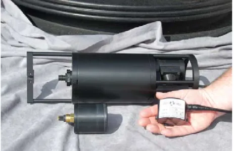
the former is a proxy for phytoplankton abundance while the latter is a proxy for small particle concentration. Unlike temperature sensors, bio-optical sensors at the time of the 1999 NOPP solicitation were relatively large, heavy, power-hungry, and hydrodynamically draggy (Figure 2)—in other words, completely incompatible with Seaglider.
As Ronald Zaneveld commented, the original Sea Tech fluorometers “would have sunk them because of their weight!”
We turned to Ron and Casey Moore at WET Labs to design and build a small combination fluorometer-backscatter sensor for Seaglider that would fit in the aft fairing flush with its surface, inte- grate with the onboard computer, and consume very little energy—a tall order for that time. Although Casey often asked, “Why can’t you make Seaglider bigger?” he persisted, and within a year he had designed a small prototype sensor that was immediately dubbed the “hockey puck” for its shape and size (a cylinder roughly one-third more voluminous than its sporting namesake).
While this version measured only chlo- rophyll a fluorescence, through consulta- tion with partner Emmanuel Boss at Oregon State University, WET Labs came up with a creative design whereby light sources and detectors were shared to measure three parameters (chlorophyll a
fluorescence plus optical backscattering at blue and red wavelengths) with only two LEDs and two detectors. This “clover leaf” model has been the optical work- horse of almost all Seaglider missions to date. Further engineering ultimately produced a low-power version of the puck that measured three parameters without sharing LEDs or detectors, enabling a Seaglider to incorporate two pucks that measure a total of six fluores- cence and optical backscattering param- eters. The “hockey puck,” now commer- cially marketed as the ECO PuckTM (Environmental Characterization Optics Puck), was a major success of the NOPP program. Offered by WET Labs, its Web site description reads: “These instru- ments incorporate a variety of options within a single basic design. The Puck is specifically designed for applications such as AUVs, gliders, and profiling floats, where space and power require- ments are critical.” Not only did NOPP nurture Seaglider, but it also nurtured development of a commercial sensor that today plays a widespread role in autono- mous ocean observing.
diSSOlVed OxygeN SeNSOrS Together with industrial partner Sea-Bird Electronics and NOPP support, we added an oxygen sensor into the standard sensing suite for Seagliders. As with the conductivity and temperature sensors, Sea-Bird produced specialized versions for adaptation on Seaglider. In order to reduce power consumption, all three sensors are exposed to water flushed past or through them by the forward speed of the glider. Although this approach requires raw signals to be processed for speed-sensitive response corrections, the power savings are
figure 2. Chlorophyll fluorometers. a Sea tech fluorometer, circa 1990, (background) and a pair of Wet labs eCO-puck fluorometer/backscatter sensors (foreground). The puck in hand was developed through NOPP sponsorship while the other is a similarly miniaturized model.
Photo courtesy of Ian Walsh, WET Labs Inc.
considerable. In Sea-Bird’s preferred water-column profiling configurations, sensors are exposed by pumping samples past them at a known rapid rate. Yet even with the presently offered pump (much more efficient than the one available more than a decade ago during Seaglider design), energy consumption of a contin- uously pumped system is equivalent to roughly a third of the overall Seaglider energy budget.
Sea-Bird approached the NOPP project partnership in a novel and generous manner that provided the Seaglider with needed instrumenta- tion while at the same time insulating it from the contractual complications of product development with a univer- sity. Rather than accept a subcontract from UW for development activities, Sea-Bird President Norge Larson had his company contribute engineering support to the specialized Seaglider versions of Sea-Bird sensors in anticipation of real- izing the return of future instrument sales for Seagliders. Ultimately, Sea-Bird furnished specialized sensor instrumen- tation to all three AOSN glider devel- opers and is currently offering a single, stand-alone module for commercial versions of these vehicles.
The Sea-Bird oxygen sensor employed on Seagliders is a Clark electrode.
Subsequent to NOPP support, an optical quenching measurement of dissolved oxygen has been developed and offered commercially by Aanderaa Data Instruments and is called the Optode. These two sensors have been installed together on a few Seagliders with the benefit that their performance in collecting oxygen profiles can be compared and mutually calibrated. As with seawater conductivity, the ability of
Seagliders to routinely profile while both diving and climbing through the water column enables more accurate evaluation of sensor response than if samples were collected in only one profile direction.
SMart aNd SMarter SOftWare
Seagliders use a relatively primitive processor, chosen for its low-power char- acteristics, that provides the approximate computing power of a 1980s vintage personal computer. The incorporation of additional sensors naturally required increasingly complex software, but expe- riences of loss and near-loss of equipment provided extra motivation to develop more sophisticated software. A pair of Seagliders launched in the Labrador Sea in September 2003, upgraded in sensor complement by NOPP support, began reporting “file open” errors in December while attempting to cross from offshore
Labrador back to the Greenland side of the basin. The vehicles continued to dive and attempt to record measure- ments, but onboard data-handling difficulties snowballed to impair Iridium communications. Despite valiant efforts by UW software specialists Neil Bogue and Jim Bennett to work around the
problems, both gliders ultimately went silent. A few weeks after the problems began, the National Aeronautics and Space Administration (NASA) reported touchdown of a pair of robotic landers on Mars and reported similar software prob- lems. In their case, fortunately, multiple onboard processors allowed confused computers to be rebooted by one another.
Seagliders, with a single processor, were unable to do this. Six months after their disappearance, we received a voice mail early one morning on the office tele- phone stating flatly, “This is the police in Disko Bay, Greenland. We have your instrument. It’s pink. What you want us to do with it?” This Seaglider was shipped home to Seattle, refurbished, shipped back to Greenland, and launched in the Labrador Sea again the following spring.
NOPP support enabled us to enhance software reliability considerably. The code was reconfigured to reboot if
locked up, triggered by a watchdog timing circuit requiring periodic
“petting.” In addition, complete compiled versions of the glider code could be downloaded remotely via Iridium and run, enabling revisions to be substi- tuted during a mission. A particularly dramatic example came from Seaglider’s
“ ”
thaNkS tO the iNitial deVelOPMeNtS UNder NOPP, Seaglider teChNOlOgy iS BeiNg exteNded tO iNClUde WOrk UNder iCe, exCUrSiONS tO the BOttOM Of the OPeN deeP OCeaN, aNd iNdiVid- Ual MiSSiONS laStiNg OVer a year aNd rUNNiNg CONtiNUOUSly.
first eastern hemisphere mission, part of a US Navy exercise in the Kuroshio. The bug was a long forgotten line of code that forced GPS fix longitudes to be inter- preted as in the western hemisphere, requiring a new ~ 300 kbyte version of glider code to be sent across the Pacific and executed on a solitary glider drifting at several knots in the Kuroshio. Happily, the new version solved the problem and the Seaglider performed its mission through the most severe typhoon to reach Japan in a decade. Our ONR program manager proudly briefed ten stars’ worth of admirals on the Seaglider that chugged unruffled through winds and seas that forced the exercise’s ships and airplanes to seek safe havens.
Thanks in part to improved software, a Seaglider launched September 24, 2004, in Davis Strait extended the mission endurance and range record for AUVs to seven months plus one week, and 3,750 km through the water (Eriksen
and Rhines, 2008). This glider collected sections along transects the length and breadth of the Labrador Sea and encoun- tered eddies strong enough to trap it.
Fortunately, due to reliability upgrades largely funded by our NOPP grant, it was able to escape the eddies and return to the edge of the Greenland conti- nental shelf offshore its capital, Nuuk, to be recovered (Eriksen and Rhines, 2008; Hátún et al., 2007). (A Seaglider launched in the Gulf of Alaska near Ocean Station Papa at the end of August 2008 has surpassed the endurance record for a successfully completed AUV mission set in the Labrador Sea and will set a new one of 9.5 months if recovered in mid June 2009, as planned.)
SCieNCe highlightS
Seaglider undertook its first mission with the newly acquired “hockey puck”
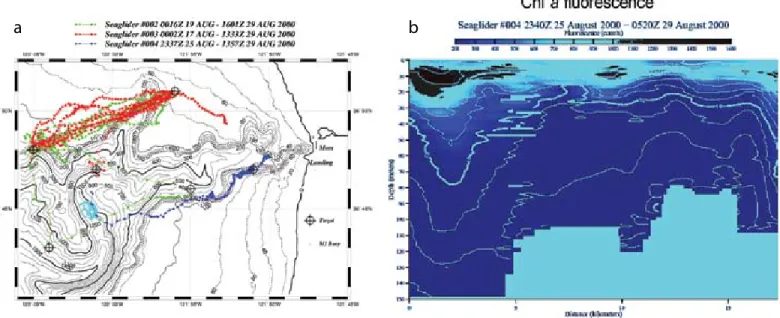
fluorometer in August 2000 in Monterey Bay, California. For five days it profiled
the transect in Figure 3a, occasion- ally veering off course due to strong currents associated with the Monterey Canyon but faithfully correcting course and reporting data and position after every dive. One of the interesting features observed in this early mission was phytoplankton thin layers that appeared to be hydrodynamically concentrated and dispersed (Figure 3b).
Similar features that extend for tens of kilometers and persist for weeks have since been observed by Seagliders off the Washington coast. Within the next year, the new “clover leaf” combination fluorescence and optical backscattering sensor was incorporated into Seaglider, which was then deployed for longer missions off the Washington coast.
As originally conceived, our NOPP project was to help state and county government agencies in detecting hypoxic conditions and siting a major metropolitan sewage outfall by using
figure 3. Monterey Bay deployment of three Seagliders in august 2000, the first multi-glider demonstration experiment. (a) tracks of three Seagliders. Seaglider S/N 004 (blue symbols) was fitted with a prototype fluorometer “puck.” (b) Chlorophyll a fluorescence along the section on the south rim of Monterey Canyon.
Figure courtesy of B.S. Sackmann
a b
Seagliders to survey oxygen and plankton distributions in Puget Sound.
In practice, swift tidal currents and large density contrasts between riverine and oceanic waters proved quite challenging for Seagliders. Battery drain in such conditions constrained missions to only about a month’s duration, requiring considerable effort to continuously resolve seasonal and interannual differ- ences. Boat traffic posed an additional challenge. After losing two gliders in one week, presumably due to collision, we decided to abandon inland waters for the open sea.
The first mission off the coast began in April 2002; Seaglider was launched at the mouth of the Strait of Juan de Fuca and programmed to make its way offshore.
The plan was to have it head southwest across the Washington continental shelf and into waters overlying the slope (which it did); however, fighting the tidal currents across the continental shelf took almost two weeks and expended considerable battery power. Because of its extended coastal proximity and the productive season (spring), hundreds of barnacles settled on the hull. These factors led us to make future deploy- ments in deeper water at the continental shelf edge. By making most dives to 1-km depth, to our relief, neither barnacle nor algal fouling was experi- enced again off the Washington coast.
Unlike moored upper ocean instru- ments, euphotic zone exposure is typi- cally ~ 10% or much less for Seagliders in deep water, enabling half-year missions free from fouling. Some of the findings from a multi-year sequence of multi-month Seaglider deployments are reported in the special issue of Limnology and Oceanography (Dickey et al., 2008;
Perry et al., 2008) that focuses on science accomplishments of autonomous and Lagrangian platforms and sensors.
The near continuous time series of Washington continental slope sections (more than five years long at this writing) is sufficient to describe dramatic interannual signals, such as the ebb and flow of upper-ocean alongshore trans- port (Figure 4). While the net along- shore transport in the upper 1 km is indistinguishably small, episodes lasting several months with amplitudes of
~ 5–20 Sverdrups dominate the record, dwarfing any seasonal cycle. Proximity to the bifurcation of West Wind Drift into subpolar and subtropical gyres and the wobble of these gyres is a likely source of strong variability.
Incorporation of oxygen and bio- optical sensors on Seagliders has
enabled studies of carbon flux inferred from the structure and temporal evolu- tion of the measured signals in the upper ocean. Craig Lee (University of Washington, pers. comm., 2008) used Seagliders during the three-month 2008 North Atlantic spring bloom study to identify major carbon flux events, observable to depths of 900 m.
Nicholson et al. (2008) used a sequence of repeat survey sections near the Hawaii Ocean Time-series (HOT) site to diagnose variations in dissolved oxygen, relate them to local generation, and constrain estimates of diffusive oxygen flux in part of the water column.
Successful Seaglider missions at the HOT site prompted the University of Hawaii to become the first owners and operators of Seagliders outside UW.
The original plan for NOPP had
figure 4. alongshore transport in the upper 1 km from 47°N, 128°W to the continental shelf edge off Washington (~ 230 km) estimated in 110 sections over 5+ years. Bar width indicates duration of each section. 1 Sv = 106 m3 s-1 volume transport.
envisioned two pucks, one measuring chlorophyll a fluorescence and the other optical backscatter. Consequently, the Seaglider aft fairing was constructed with two holes—one for each puck—to be positioned side by side. Because the
“clover leaf” design was so successful, allowing both fluorescence and back- scatter to be measured on a single puck, for many years the second hole was occupied with a dummy plug. For the 2008 North Atlantic spring bloom experiment, a second puck was added to Seagliders—an ECO Puck with a redun- dant chlorophyll fluorometer, a fluorom- eter for chromophoric dissolved organic matter (CDOM), and a third wavelength of optical backscatter. During this exper- iment, four Seagliders were launched southwest of Iceland in early April, prior
to the start of the bloom. They were tasked to follow two Lagrangian mixed- layer floats instrumented with a more complete suite of bio-optical sensors and to provide a larger environmental context. For two months, they faithfully followed one float until it had to be retrieved (Seaglider track in Figure 5), but remained for an additional month, doing survey grids and continuing to follow bloom dynamics through late June. When early results of this experiment were presented at the Ocean Carbon and Biogeochemistry workshop in July 2008, a senior oceanographer who had been heavily involved in the Joint Global Ocean Flux Study (JGOFS) made the comment that it looked like JGOFS had been replicated, but this time by robots!
iMPaCtS aNd OUtreaCh The original NOPP grant supported two graduate students, one each at UW and the University of Maine. With the proliferation of Seagliders and additional products, additional graduate students (now nine) and postdocs (two) at our universities are gaining experience in studying the ocean with Seagliders. As part of their training, they learn how to interpret data uniquely collected by gliders. Sensor data offer additional chal- lenges and opportunities, for example, interpreting chlorophyll fluorescence quenching (Sackmann et al., 2008) and developing new protocols for sensor calibration (Craig Lee, University of Washington, pers. comm., 2008).
Outreach activities have been many and varied, ranging from talks in elementary schools to public lectures at universities and articles published in print and electronic media from the local college newspaper to popular technology publications in multiple languages.
When the Chief of Naval Research testi- fied before the Senate Armed Services Committee Subcommittee on Emerging Threats and Capabilities in March 2005, ONR chose to have a Seaglider as one of the two exhibits it was allowed (the other was body armor for Marines) (Figure 6).
The demand for Seagliders has steadily grown since the start of our NOPP grant, both within and outside UW. In response, the Seaglider
Fabrication Center (SFC) was established at UW to fabricate and service vehicles as well as to train personnel to handle and pilot them. Customers have included scientists at other universities and the Naval Oceanographic Office. The SFC was created as an interim step to full commercialization to satisfy the need to
figure 5. track of four Seagliders during the 2008 subpolar North atlantic Spring Bloom program as they followed a lagrangian mixed layer float (eric d’asaro and Craig lee, University of Washington, pers. comm., 2008).
Figure courtesy of C.M. Lee and A.M. Gray
provide Seagliders to the ocean commu- nity while maintaining reliability and incorporating new technology develop- ments as they become fully tested by UW research groups. The transition to commercialization was begun in June 2008 with the licensing of Seaglider technology to iRobot Corporation of Bedford, MA.
aCkNOWledgeMeNtS This work was supported by National Science Foundation grant OCE-9911036.
We gratefully acknowledge the dedica- tion and hard work of our partners C. Moore, R. Zaneveld, N. Larson, J. Newton, and R. Shuman, and of our research staff and collaborators J. Osse, R. Light, T. Wen, T. Lehman, P. Sabin, A. Chiodi, N. Bogue, J. Bennett, T. Swanson, Y. Kuga, and W. Fredericks.
refereNCeS
Davis, R.E., C.C. Eriksen, and C.P. Jones. 2002.
Autonomous buoyancy-driven-underwater gliders.
Chapter 3 in: The Technology and Applications of Autonomous Underwater Vehicles. G. Griffiths, ed., Taylor and Francis, London.
Dickey, T.D., E.C. Itsweire, M. Moline, and M.J.
Perry. 2008. Introduction to the Limnology and Oceanography Special Issue on Autonomous and Lagrangian Platforms and Sensors (ALPS).
Limnology and Oceanography 53:2,057–2,061.
Eriksen, C.C., and P.B. Rhines. 2008. Convective to gyre-scale dynamics: Seaglider campaigns in the Labrador Sea 2003–2005. Chapter 25 in Arctic- Subarctic Ocean Fluxes: Defining the Role of the Northern Seas in Climate. R. Dickson, J. Meincke, and P. Rhines, eds, Springer-Verlag.
Hátún, H., C.C. Eriksen, and P.B. Rhines. 2007.
Buoyant eddies entering the Labrador Sea observed with gliders and altimetry. Journal of Physical Oceanography 37:2,838–2,854.
Nicholson, D., S. Emerson, and C.C. Eriksen. 2008.
Net community production in the deep euphotic zone of the subtropical North Pacific gyre from glider surveys. Limnology and Oceanography 53:2,226–2,236.
Perry, M.J., B.S. Sackmann, C.C. Eriksen, and C.M.
Lee. 2008. Seaglider observations of blooms and subsurface chlorophyll maxima off the Washington coast. Limnology and Oceanography 53:2,169–2,179.
Rudnick, D.L., and M.J. Perry, eds. 2003. ALPS:
Autonomous and Lagrangian Platforms and Sensors. Workshop Report, 64 pp. Available online at: http://www.geo-prose.com/ALPS/ (accessed April 6, 2006).
Rudnick, D.L., R.E. Davis, C.C. Eriksen, D.M.
Fratantoni, and M.J. Perry. 2004. Underwater gliders for ocean research. Journal of the Marine Technology Society 38:73–84.
Sackmann, B.S., M.J. Perry, and C.C. Eriksen. 2008.
Seaglider observations of variability in daytime fluorescence quenching of chlorophyll-a in Northeastern Pacific coastal waters. Biogeosciences Discussion 5:2,839–2,865. Available online at:
http://www.biogeosciences-discuss.net/5/issue4.
html (accessed April 6, 2009).
Tait, J.B. 1967. The Iceland-Faroe Ridge International (ICES) “Overflow” Expedition, May–June, 1960. Rapport et Procès-Verbaux des Réunions, vol. 157, Conseil Permanent International pour l’Exploration de la Mer, Andr. Fred. Høst et Fils, Copenhagen.
The Economist. 2008. Sea gliders: Run silent, run green.
Science and Technology, February 28, 2008.
figure 6. Seaglider outreach exhibit at US Senate armed Services Committee meeting of the Subcommittee on emerging Threats and Capabilities, Caucus room, russell Senate Office Building, March 9, 2005. C.C.e. confers with Sen. h. Clinton (d-Ny). Photo courtesy of John F. Williams, Office of Naval Research