119
Copyright@SPSD Press from 2010, SPSD Press, Kanazawa
The Favorable Settlement Relocation Process After the 2011 Earthquake and Tsunami Disaster in Japan by Evaluating Site Environments and Accessibility
Misato Uehara
1*, Tadayoshi Inoue
2,Gen Shintaku
11 Departments of Forest Science, Faculty of Agriculture, Shinshu University 2 Japan Society of Urban and Regional Planners
* Corresponding Author, Email: [email protected] Received 4 December, 2013; Accepted 18 June, 2014
Key words: Disaster, Citizen and public co-determination, Resilience, Community planning, Fukushima, Semantic Differential Method, Neighbourhood relocation
Abstract: As a new estimate, we analyzed a mismatch between public evaluation and planning decisions. In this paper, we call this mismatch “the failure of spatial planning for sustainable development”. This paper will compare two adjoining municipalities (α town and β city) that employed different settlement relocation processes after the Great East Japan Earthquake and Tsunami (March 11, 2011). α town selected seven new candidate relocation sites from non surplus land of pre-existing city plan by a citizen participation and holistic land selection process. On the other hand, β city selected unused city planning sites (pre-existing), which were already planned before the 2011 disaster. The reconstruction process of α town involved citizen and public co-determination, whereas β city only determined a quick-fix solution without renewed planning.
Unfortunately, most disaster reconstruction efforts in Tohoku appear similar to β city. With a field survey on 16 relocation sites in 2012, we asked 80 university students to evaluate the environments of the two municipalities' relocation sites by Semantic Differential Method. As a result, α town’s relocation sites, which are determined with citizen and public co- determination, are higher valued that of β city. Then, by overlay, analyzing the accessibility of the relocation sites with a new transportation network, we found that the accessibility of relocation sites in α town is better. Our result suggests that planning processes with low administrative agency and public participation, tend to be more successful in producing an attractive redevelopment plan.
1. INTRODUCTION
A distinguishing feature of this study is the evaluation of relocation sites
in the planning process early after big natural disasters, since land formation
technology can make any land to similar housing environment within a few
years. We found the damage of earthquake and tsunami differs with different
site characteristics; land on historic fens incur severe earthquake damage,
and land on historic sea beds incur serious tsunami damage. Hence site
planning is important for avoiding damage from natural disasters—a lack of
local resident’s knowledge of site character will further worsen the damage.
Formerly, many Japanese people believed that modern technology could prevent damage from any natural disaster, but this belief is proved at fault by the 2011 Earthquake and Tsunami Disaster in Japan. Thus, we should change from the fragmentary approach to a new holistic approach with citizen participation.
In fact, the disasters of our society are becoming more and more frequent and unpredictable. Unfortunately, many relocation sites after the disasters are still based on fragmentary approaches. Considering that, our goal in this paper is to evaluate the post-disaster land selection result with different planning processes.
Amendola et al. (2008) indicated that between 1984 and 2003, more than 4 billion people were affected by extreme natural events, and that between 1990 and 1999, the cost of natural disasters was more than 15 times higher than during the period 1950‒ 1959 (World Bank, 2006). The research noticed that while there had been progress toward integrated and proactive disaster risk management in many countries, the standard planning approaches to disasters were too reactive.
Moreover, in most countries there has been little integration among the relevant responsibilities— for example, disaster prevention generally has nothing to do with land-use planning. In addition, Amendola et al. (2008) indicated, “better is more important than bigger in redevelopment from natural disasters.” Though it is often the case that in the immediate aftermath of disasters (for example, Hurricane Katrina in New Orleans, Louisiana), hopeful boosters and politicians proclaim that the reconstructed area will be bigger and better.
Kates, et al. (2006) suggested that natural hazard and reconstruction research over the past 60 years provided a comparative and historical perspective on the reconstruction of New Orleans after Hurricane Katrina. In addition, Golant and Burton (1970) attempted to derive meaning from 12 hazard situations in a sample group of subjects using the Semantic Differential method, and Wu and Lindell (2004) compared earthquake recovery plans for the city of Los Angeles, California, and Taichung County in Taiwan. HUD’s Office of Policy Development and Research (1995), which conducted an earthquake mitigation report after the earthquake in Northridge, California, concluded a mismatch between federal mitigation and local recovery needs—Almost 80% of damaged residential units were multi-family housing, particularly low-cost rental housing; unfortunately, the city’s recovery programs were designed to serve middle-class owners of single-family dwellings. This suggests that one way of overcoming the limitations for land-use planners is to establish links with their counterparts in emergency management.
Although these studies are useful in examining the political initiatives of reconstruction planning, they lack residents’ and next-generations’ opinions on the actual site planning process. Users’ needs and preferences, in addition to those of the politicians and architects, should be taken into consideration during the relocation/new settlement selection process.
There is little information available on this aspect for Japanese city planning or sustainable planning in Asia, even though many Asian and Oceanian countries have experienced similar natural disasters; for example, large earthquakes have happened 19 times in 10 years:
1. Lushan earthquake, Magnitude (M)7.0, April 20, 2013, China 2. Sistan and Baluchestan earthquake, M7.8, 2013, Iran
3. Aceh earthquake, M8.6, April 11, 2012, Sumatra, Indonesia
4. Visayas earthquake, M6.7, February 6, 2012, Philippines
5. Van earthquake, M7.1, October 23, 2011, Turkey 6. Sikkim earthquake, M6.9, September 18, 2011, India 7. Tohoku earthquake, M9.0, March 11, 2011, Japan 8. Burma earthquake, M6.9, March 24, 2011, Myanmar
9. Christchurch earthquake, M6.3, February 2011, New Zealand
10. Sumatra earthquake and tsunami, M7.7, October 25, 2010, Indonesia and Malaysia
11. Yushu earthquake, M6.9, April 2010, China
12. Sumatra earthquake, M7.9, September 30, 2009, Indonesia 13. Sumatra earthquake, M8.5, September 12, 2007, Indonesia 14. Sichuan earthquake, M 8.1, May 12, 2008, China
15. Java earthquake, M6.2, May 27, 2006, Indonesia 16. Kashmir earthquake, M7.6, October 2005, Pakistan
17. Indian Ocean earthquake and tsunami, M9.1, December 2004, Indonesia
18. Chuetsu earthquake, M6.8, October 2004, Japan 19. Hokkaido earthquake, M8.3, September 2003, Japan
The 2011 Tohoku earthquake in Japan was the worst disaster resulting from a single earthquake, which caused a tsunami and subsequent accident at the Fukushima nuclear plant. Hence, this case should be a useful lesson for other countries susceptible to this type of disaster.
Generally, housing reconstruction passes through three stages, the last of which is permanent housing, which is often at a new site away from the disaster. Until now, a few reports have discussed this process, but did not cover the effect of early adaptation and citizen participatory planning after natural disasters.
In this paper, our approach is different in its evaluation of early adaptive planning for natural disasters. We compared two different relocation plans:
one is a holistic land selection plan in a small town; the other is a large municipality's basic substitution process of unused city planning zones for housing. The goal is for the results and discussion to meaningfully contribute to design studies and planning approaches toward sustainable development.
2. METHOD
March 11
th, 2011 saw the tragedy of the Great East Japan Earthquake and Tsunami, even though many researchers’ extensive disaster information compilations had already been used to prepare hazard maps. The number of fatalities and missing people was 18,498, and the number of collapsed housed was up to 40,438. From these numbers, we assume that it is important that local people have an understanding of the potential for disaster in their neighborhoods. In this paper, we define environmental evaluation as in experts having an understanding of the site characteristics of their neighborhoods.
The numerous lost lives and collapsed housing in the 2011 disaster seem
to be a failure of sustainable development. Further planning, without
reviewing the above failures, is wrong. Hence, in this paper, we describe the
process for design of sustainable development as a confirmation of citizen -
public cooperation. We believe that a holistic and open planning approach
aiming at a sustainable development, is a useful perspective.
2.1 Field survey of two adjoining municipalities with opposite planning processes for rehabilitation projects following Japan’s 2011 Earthquake and Tsunami
The evaluation of relocation sites is critical. As Wu, et al. (2004) pointed out, a mismatch between the allocation of resources and recovery needs occurred after the Northridge, California earthquake, resulting in a significant loss of funds.
However, there have been few case studies that have examined the reconstruction programs under the context of local residents' evaluation and opinions, primarily because reconstruction processes tend to be rushed.
As a new estimate, we analyzed a relationship of mismatch between peoples’ evaluations and the spatial planning decisions.
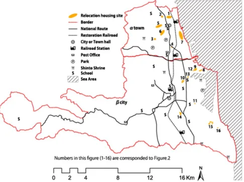
We selected α town and β city in Fukushima Prefecture for comparison (Figure 1). While the damage resulting from the earthquake and tsunami
were similar, the revival processes of each area were quite different:
small α town took a holistic land selection approach, while big municipality β city used a substitution method.
Fig 1. Outline of study area
α town, a small municipality, selected seven relocation sites that were proposed (and prioritized) by the local people. β city, a large municipality,
α β
substituted pre-existing unused city-managed sites for its new relocation sites (nine places).
We used post-construction photographs of the two municipalities' relocation sites in December 2012 in order to conduct our comparison. The photographs of the sites (Figure 3) are important because land formation technology can make any land into a similar housing environment within a few years. It will become difficult to see natural disaster possibilities due to the sites' land use history; for example, houses on marshes and paddy fields are more vulnerable to earthquake liquefaction and tsunami damage.
2.2 Environmental evaluations using a Semantic Differential Method
In 1967, Osgood, Suci, and Tannenbaum introduced the Semantic Differential Method in their book, The Measurement of Meaning. In this method, the respondents are asked to compare a series of bipolar adjective pairs with respect to an anchor concept. The respondents decide whether a concept (for example, land for development) is associated more with suitable or non-suitable, or safe or unsafe conditions and to what degree.
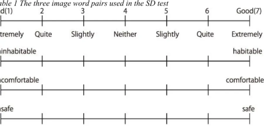
A Semantic Differential scale is a combination of the adjective checklist and the rating scale. In the scale, a single topic is described by at least seven points, with opposing adjectives or short phrases at each end. A point value is assigned for each of the spaces on a seven-point scale so that a set of seven spaces or a continuous line between the opposing adjectives could be constructed. When the positive adjective is on the right side, assign the values 1‒7 from left to right; for example, 1 = uninhabitable, 4 = no opinion, 7 = habitable (Table 1). Sixteen real new housing sites and three image words (in Japanese) were picked for our test.
Table 1 The three image word pairs used in the SD test
In this test, image and perception preferences were scored on a seven- point scale. The total score was calculated by summing the values circled.
While we believe that users’ needs and preferences should be taken into consideration during the relocation selection process, it is often difficult for afflicted people to evaluate objectively (for example, people tend to believe their relocation site is better than other suggested sites). Our questionnaire subjects are sophomore university students. The semantic differential test was given during December of 2012. Paper questionnaires lasted approximately 20 to 25 minutes.
Before we can carry out a test to compare two groups’ (municipalities’)
site evaluation, we need to test whether the sample variances are
significantly different. In this case, the variances of the two groups are the same; it would be right to compare the two samples (different revival processes) using t –test score.
2.3 Layer analysis to evaluate the settlement relocation site’s accessibility to renewed traffic network and public facilities
The accessibility of the relocation site’s victim community is important regarding the issue of sustainable development. Unfortunately, many post- disaster reconstruction projects failed to consider relocation holistically after the 2011 disaster. Post-tsunami recovery sites located in inconvenient places is a waste of both tax money and donations made to the disaster area. Hence, we investigated accessibility of the sites to the new traffic network by layer analysis.
We superpose two municipalities’ planned housing sites and renewed railroads and other public facilities. This area’s railroad was destroyed by the 2011 tsunami disaster.
3. RESULTS
3.1 Field survey of two adjoining municipalities with opposing planning processes for relocation sites for Japan’s 2011 Earthquake and Tsunami.
After the 2011 disasters, the housing recovery passed through three stages: (1) emergency shelter; (2) temporary shelter and housing; and (3) permanent housing.
Emergency shelters are usually established after a disaster at the instigation of individuals based on chance availability, convenience, proximity, and perceived safety. Temporary housing and shelter is often sought in the homes of friends and relatives, though mass care facilities are also used. Following the 2011 disaster, it was decided that the last stage of housing reconstruction (permanent housing) would not be built within the tsunami disaster area, but rather on higher, more stable ground to avoid future tsunami disasters.
In α town, citizen and public sectors turned most suitable land into new community housing sites. They did not adhere to the existing land use plans.
The planning process of α town was a rare case, as the revival plan took the residents’ opinions into consideration.
Conversely, β city, a large municipality, basically substituted unused sites
into relocation sites (nine places) from existing planned housing zones,
which had been decided before the 2011 disaster. In reality, most
municipalities adopt this method for relocation because they would like to
save time rather than workshop with many victimized residents. Figure 2
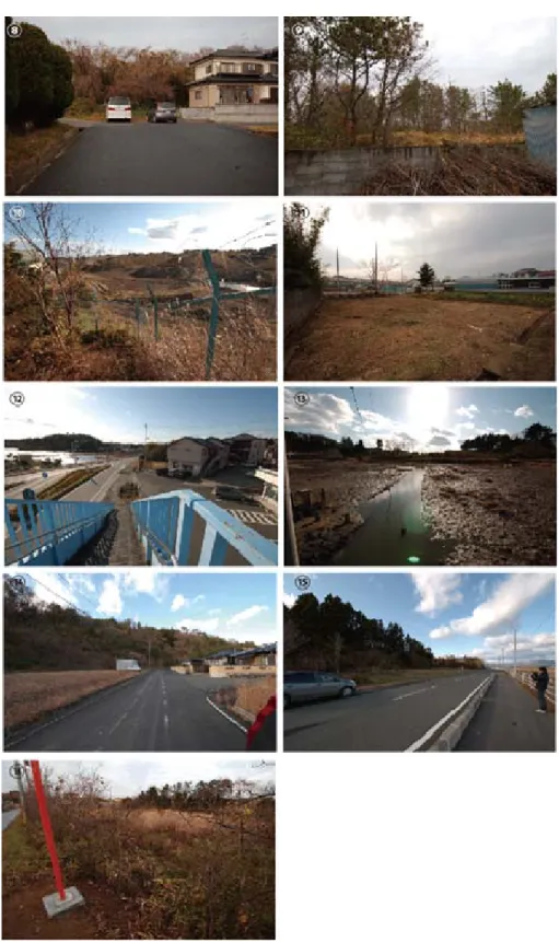
shows six permanent housing sites in α town located along the boundary of
forest and farmland, while Figure 3 shows four permanent housing sites in β
city located on marshes and paddy fields, which will be at risk of potential
flooding. Because β city’s sites were secured prior to the earthquake in 2011,
the examination of the vulnerability of the disaster was not performed
thoroughly.
Figure 2 Seven photos of relocation settlements (Numbers in this figure corresponded to Figure 5)
Figure 3. Nine photos of settlement relocation candidate sites in β city (Numbers in this figure correspond to Figure.5)
3.2 Environmental evaluations using a Semantic Differential Method
In order to conduct a Semantic Differential Method test, a total of 16
photographs of the relocation sites for the two municipalities were displayed
with a brief description (in Japanese). In this test, preferences on the images
were scored along a seven-point scale. A score of 7 points means that the subject has a strong positive impression of the sample, while a score of 1 point denotes a strong negative impression.
The survey results are summarized in Figure 4. Overall, the evaluated scores of relocation sites were significantly higher in α town than β city. In other words, the majority of the 80 students preferred the smaller municipality’s relocation sites to the large municipality’s relocation sites (Figure 4).
Figure 4 The comparison of settlements relocation candidate environments evaluation betweenα town (seven sites) and β city (nine sites)
The site evaluation of habitable(7) to inhabitable(1) was significantly higher in α town (mean 4.3) than in β city (mean 3.5), with t=9.86, p=0.001 (two-tailed), df=1118.
The site evaluation of comfortable(7) to uncomfortable(1) was significantly higher in α town (mean 4.9) than in β city (mean 4.1), with t=11.91, p=0.001 (two-tailed), df=1118.
Similarly, the site evaluation of safe(7) to unsafe(1) was significantly higher in α town (mean 4.6) than in β city (mean 3.7), with t=10.55, p=0.001(two-tailed), df=1118.
The results suggest that citizen and public co-determination will lead to more favourable outcomes of planning than quick-fix determination without renewed planning.
From the study, we also inspected a relationship (and a validity) of mismatch with peoples’ evaluation’ and the spatial planning decision.
Surprisingly, there is not much difference in the time period needed to implement the plan in α town and β city, for in β city it takes time to persuade the residents to accept the plan that they were not involved with making. Relating to this study, we would like to show the result of actual reconstruction work in these two municipalities.
Interestingly, the results showed that fewer residents in β city would move to the reconstructed places (Kahoku Shimpo, 2012). On the other hand, more residents in α town actually got relocated at the locations that they chose.
3.3 Relocated housing sites’ accessibility to mobility and convenience for relocation
People might argue that the above-mention evaluation is not sufficient in terms of site convenience. Figure 5 shows the location of the main transportation corridors (national road and restoration railroad) around the relocation sites for both of the two municipalities.
Figure 5 Result of each reconstruction site's accessibility to new traffic network by layer analysis. (β city candidate site seems smaller than α town site. Indeed, β city site is surplus
land of past city planning, and α town site is a)
In particular, α town’s relocation sites appear to be convenient to the town center and traffic network nodes because of α residents’ physical site determination demands. . On the other hand, β city’s relocation sites do not appear to be convenient to the city center and traffic network nodes because β city’s site planning allocated unsold or unused land in pre-quake city planning for physical site determination.
4. DISCUSSION
The purpose of the study is to evaluate the results of different reconstruction processes in Japan after the 2011 earthquake and tsunami disaster.
In this paper, we inclusively accomplished an analysis of the mismatch between peoples’ evaluations and the spatial planning decisions. We have found considerable differences in landscape preferences amongst the two municipalities' disaster relocation site selections.
Many students did not prefer β city's relocation sites’ environments despite the fact that β city has many possible land selections from its 197.7km
2area, compared with α town’s (46.35km
2).
This study’s result may be similar to the actual residents’ opinions.
In α town, victims’ wish for getting a new detached house could be accomplished since relocation settlements were selected using residents’
opinions, while β city could not accomplish this. Because of the poor relocation selection, some condominiums were kept vacant in β city (Kahoku Shimpo, 2012).
Moreover, the result of accessibility analysis shows that the outcome with citizen and public co-determination planning is better than quick-fix determination without renewed planning.
As a result, we achieved an indication of the importance of a holistic planning process for natural disasters which has not been sufficiently analysed.
Compared to previous research, this study offers additional evidence on the value of citizen participation and holistic land use planning in the early stages of the reconstruction planning processes.
This paper's preferred planning process appears to be a rare case, so additional evaluation on different types of sites and demographic groups is necessary.
REFERENCES
A.Amendola, J.Linnerooth-Bayer, N.Okada, P.Shi (2008). “Towards integrated disaster risk management:case studies and trends from Asia- Natural Hazards”, Natural Hazards, Volume 44(2) , 163-168.
Kahoku Shimpo (local newspaper). “Hesitation of elder tenants to disaster relocation housing” (August 10, 2012). Accessed on November 8, 2014.
http://www.kahoku.co.jp/news/2012/08/20120810t65018.htm
Jie Ying Wu, Michael K. Lindell (2004). “Housing Reconstruction After Two Major Earthquakes:The 1994 Northridge Earthquake in the United States and the 1999 Chi-Chi Earthquake in Taiwan,Disasters”, Disaster , 28(1), 63-81.
R. W. Kates et al, (2006). "Missing from rapid recovery has been adequate attention to the needs of evacuees who lived in rental housing, especially public housing", PNAS, National Academy of Science, Washington, DC.
R. W. Kates, C. E. Colten, S. Laska and S. P. Leatherman (2006). “Reconstruction of New Orleans after Hurricane Katrina:A research perspective”, PNAS, 103(40), 14653-14660.
Sinchi Town Reconstruction Development Plan of the 9th [6th ] change (August 5, 2014).Accessed on August 25, 2014. http://www.shinchi-town.jp/pdf/hontai1.pdf.
Stephen Golant and Ian Burton (1970). “A Semantic Differential Experiment in the Interpretation and Grouping of Environmental Hazards”, Geographical Analysis, 2(2), 120–134.
World Bank (2006). “Hazards of nature, risks to development: an IEG evaluation of World Bank assistance for natural disasters”, The World Bank, Washington, DC.