全世界の国家地図作成機関による地球地図プロジェクト
小清水寛、丸山弘通、坂部真一、木佐貫順一、永山透、榧場新一、安部雅俊、鵜生川太郎
GLOBAL MAPPING PROJECT BY NATIONAL MAPPING ORGANIZATIONS ON THE GLOBE
H. KOSHIMIZU, H. MARUYAMA, S. SAKABE, J. KISANUKI, T. NAGAYAMA, S. KAYABA, M. ABE and T. UBUKAWA
Abstract
地球地図プロジェクトは、全球陸域の地理情報を統一仕様で整備するプロジェクトであり、
地球地図データは、解像度 1km 程度のベクタ・ラスタ8レイヤのデータセットによって構 成されます。地球地図第一版整備後、5年毎にデータセットが更新される予定であるため、
ゆくゆくは全世界の環境の変化を一括して把握することが可能となり、環境政策立案の基礎 的資料となり得るでしょう。地球地図プロジェクトを巡る新規の取り組みとして、包括的な 全球土地被覆データおよびそのためのグランドトゥルースデータベース整備を目的とする
「GLCNMO」や、地球地図の一般向けの利用拡大に向けたアプリケーションプログラムの 実施が挙げられます。以上のような方向性をより確実にするためには、データの作成・更新 が滞りなく実施される体制構築が不可欠であり、各国地図作成機関との協力関係に加えて、
大陸規模の空間データ基盤との連携が検討されています。
Keywords: 地球地図(Global Mapping), 全球土地被覆データ(GLCNMO), 地球地図国際運営委員会(ISCGM)
Introduction
Global Mapping project is advocated to accurately describe the present status of the global environment in international cooperation, aiming to contribute to sustainable development. In this
conference, we summarize the status of the project and cooperative partnership with respective national mapping organizations and regional spatial data infrastructures initiatives. Then, we explain the specifications and use of Global Map data. Finally, we refer to recent activities such as
‘GLCNMO’ in ISCGM and ‘Global Map School’
in Japan.
小清水:茨城県つくば市北郷1番,国土地理院,
℡029-864-6910, E-mail: [email protected]
Abstract of Global Mapping project
Progress of Global Mapping project
Global Mapping Project is an international collaborative initiatives through voluntary participation of national mapping organizations (NMOs) of the world, aiming to develop globally homogeneous geographic dataset at the ground resolution of 1 km. Primary objectives of the project is to contribute to sustainable development through provision of basic framework geographic dataset.
The project was proposed by Ministry of Construction of Japan (present Ministry of Land, Infrastructure and Transport of Japan) in 1992 and International Steering Committee for Global Mapping (ISCGM) was established in 1996.
ISCGM consists of twenty members (as of August, 2006) who represent NMOs and regional
geographic information organizations, and its secretariat has been situated at the Geographical Survey Institute (GSI) of Japan.
Global Mapping was included in “the Plan of Implementation” document of the World Summit on Sustainable Development (WSSD) in 2002, and was registered to WSSD Type 2 initiative with the goal of completion of global coverage by the year 2007.
Status of Global Mapping Project
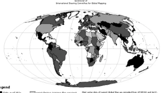
As of August, 2006, 149 countries and 16 regions that correspond to 92% of the land area of the Earth participate in the project, and country-specific Global Map data of 23 countries has been completed (See Figure 1.). Completion of data development of the land area of Global Map Version 1 is supposed to be December, 2007, and further international cooperation of respective NMOs is indispensable.
Figure 1. Status of Global Mapping Project
For the purpose, it is preferable that national spatial data infrastructures (SDI) and regional SDI are developed all over the world, and the Global
Map data are updated linking with these framework.
ISCGM pays close attention to the Americas
Global Map project as such an activity. It is an initiative of the Pan-American Institute for Geography and History (PAIGH) aiming to develop a SDI on the Americas under an liaison between PAIGH and ISCGM. Geographic information under developing would be based largely on existing Global Map data. The Americas Global Map is planning strategies for communicating with cartographic agencies and other relevant bodies that have not participated in the Global Mapping project. ISCGM expects an effort of the Americas Global Map as a new component of the Global Mapping project.
Collaboration with Permanent Committee on GIS Infrastructure for Asia and the Pacific (PCGIAP), which has a plan to develop pan Asia Pacific framework dataset based on Global Map, is
another example. As the initial step, a task force was set up within Working Group 2 of PCGIAP to conduct a pilot study on Asia Pacific dataset focusing on the area affected by Indian Ocean Tsunami which occurred in December 2004 (Purnawan, Ebener, Maruyama 2006).
Specifications of Global Map Data
Global Map is a digital geographic information in 1km resolution (at approx. 1:1 million scale) covering the whole land area of the globe with consistent specifications. The dataset is composed of 4 layers with vector format such as transportation, boundary, drainage, population centers, and 4 layers with raster format such as elevation, vegetation, land cover, land use (See Figure 2.).
Figure 2. Sample image of Global Map (Columbia)
These data are supposed to be developed by the efforts of respective NMOs. However, land cover layer data are being developed in a unified manner by International cooperation of NMOs under ISCGM initiative which promotes the Global Mapping projects (Such data are called
‘GLCNMO’).
All these data are approved by respective government and to be updated in every 5 years.
Access to Global Map Data
ISCGM provides completed 23 counties’ data through the internet from the ISCGM website (http://www.iscgm.org). All the data are free of charge for non-commercial purpose. For commercial purpose, users are asked to contact with the copyright holders of each countries, noted on the download site.
Use of Global Map Data
Global Map data are to be updated in every 5 years to help us grasp changes of vegetation, land cover and land use. Combining these time series data with other statistical data, environmental indices and simulation models, it is expected to prepare food supply scenarios, ecosystem conservation scenarios, water resource replenishment, environmental destruction prevention scenarios, and other for government policies.
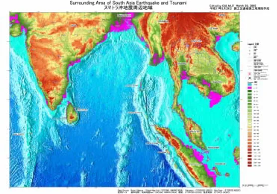
Moreover Global Map data, being developed in consistent specifications, expected to be used as a base map for overlaying regional-scale disaster information. In such cases, GSI provides a map surrounding the damaged area using Global Map data from GSI website (http://www.gsi.go.jp) aiming to contribute to decision making for emergency restoration (See Figure 3.).
Figure 3. A map of South Asia using Global Map data
Recent Activities
GLCNMO
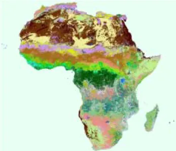
Global Mapping project has a plan to develop global land cover data by 2007 on the initiative of Working Group 4 (Chair: Prof. R. Tateishi) as land cover layer of Global Map. The planned product is
called Global Land Cover by National Mapping Organizations (GLCNMO). At present GLCNMO data have 1km pixel size with approximately 20 land cover classes created by satellite data, and will be treated as a land cover layer of Global Map (See Figure 4.).
Figure 4. Examples of GLCNMO data (Africa)
GLCNMO data are to be produced using MODIS data observed in 2003 for classification, and LANDSAT data for ground truth. At present, approximately 1000 partition data were selected as training data, and ground truth information are being collected by respective NMOs.
GLCNMO activity will contribute not only to produce basic framework dataset of the globe, but also to develop ground truth database used for this project. By publishing and sharing ground truth data to any non-commercial use, future land cover mapping attempts will be much improved.
Global Map Applications
Although global environmental problems and
disaster mitigation are the target of Global Mapping, improvement of visibility with the public is crucial problem. To cope with this problem, Ministry of Land, Infrastructure and Transport (MLIT) has organized a Committee on Application Strategy in 2003. It is a national committee consists of distinguished national experts in various fields, such as geographic information, education, environment and mass media. The objective of this committee is to formulate an application strategy to gain more recognition of Global Map and to promote practical application in Japan as well as global community. Through the meetings, various application plan were proposed and discussed.
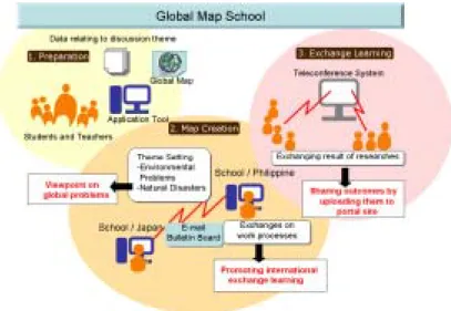
Among them, a program called ‘Global Map School’ has launched in educational field. In the program, students of domestic and foreign school communicate each other by exchanging mutual ideas with the use of Global Map data (See Figure 5.). The objectives of this program is to provide a scheme for learning international understanding
with the use of geographic information. Moreover contests that employ Global Map data as their sources (called ‘My Global Map Contest’) are to be executed. Through the program, publicity of Global Map will be improved and new application will be contrived.
Figure 5. Process of ‘Global Mapping School’ program
Conclusion
Global Mapping project is to develop the geographic information of the whole land area of the globe in international cooperation of respective NMOs with consistent specifications. ISCGM are trying to build up broad range of cooperative framework with national/regional SDI for the completion of data development of Global Map Version 1 in 2007. Global Map data are composed of 8 layers with vector and raster format, and is expected to be widely used for environmental area and disaster-related area. Recently GLCNMO activity which comprehensively develop global land cover, and Global Map applications which lead way to public use, has been launched.
Through these approach, ISCGM are looking for ways to further Global Mapping project growth.
ISCGM is convinced that all these efforts enables Global Map to be a tool for sustainable development and poverty eradication.
Reference
Purnawan B., Ebener S., Maruyama H.(2006):
“TOWARDS THE CREATION OF A REGIONAL DATASET FOR THE TSUNAMI AFFECTED AREA”, Seventeenth United Nations Regional Cartographic Conference for Asia and the Pacific, E/CONF.97/6/IP. 8