Southeast Asian Studies, Vol. 41, No. 4, March 2004
Impact of Agricultural Practices on Slope Land Soil Properties
of the Mountainous Region of Northern Vietnam: A Case
Study in Bac Ha District, Lao Cai Province
S
AKURAIKatsutoshi
*, K
AWAZUHiwasa
**, K
ONOYasuyuki
***,
Y
ANAGISAWAMasayuki
***, L
EVan Tiem
#, L
EQuoc Thanh
#,
Nittaya D
ANGTHAISONG##, and T
RINHNgoc Chau
###Abstract
In the mountainous region of Northern Vietnam, there are various systems for agricultural land use. This paper describes the impact of agricultural practices on the original properties of slope land soils with special reference to changes in soil fertility and weathering in relation to soil erosion. Soil fertility was not extremely low in the higher commune, where the cooler cli-mate would be more dominant factor controlling productivity. Therefore, the people made well-managed terraces to maintain their fields. On the other hand, in the lower commune, shifting cultivation is a dominant way of agriculture supported by the warmer climatic condi-tion. Weathering status of soils was not greatly different among the three communes, but the current climatic conditions would affect the reactivity of soils. The clay dispersion ratio of all the sites studied was very low. In addition, the clay dispersion ratio and clay content were not different among different land uses. This means that soil erosion would not have a strong impact under current farming systems in the three communes. However, activity ratios of Al and Fe (Alo/Ald and Feo/Fed) became lower after cultivation, and therefore, in the long term, slight but continuous erosion might have occurred to reduce the activity of soils.
Keywords: soil fertility, soil weathering, terracing, contour planting, shifting cultivation, soil erosion, slope land, Bac Ha, Vietnam
―――――――――――――――――
* 櫻井克年,Faculty of Agriculture, Kochi University, 200 Monobe-otsu, Nankoku City, Kochi 783–8502, Japan, corresponding author’s e-mail : [email protected]
**河津日和佐,EPMMA/JICA, Quezon City, Metro Manila 1100, Philippines *** 河野泰之;柳澤雅之,Center for Southeast Asian Studies, Kyoto University
# Vietnam Agricultural Science Institute, Hanoi, Vietnam
## Faculty of Agriculture, Khon Kaen University, Khon Kaen 40002, Thailand ### Faculty of Chemistry, Hanoi University of Science, Hanoi, Vietnam
I Introduction
In the mountainous region of Northern Vietnam, most of the people live by practicing agri-culture on slope land, in addition to cultivating lowland paddy in small valleys. The local farmers utilize the mountain area thoroughly. Due to an increase in population density and/or economic necessity, unused arable lands have already become scarce in many parts of the mountainous area of Southeast Asia. They have to depend on the current land resources.
To evaluate the productivity of a farm field, soil scientists mostly depend on analytical data on soil quality and fertility, including the pH value, clay content, the amounts of exchangeable cations, available phosphorus, nitrate and ammonium, total carbon, and total nitrogen, and so on. This is an appropriate approach when we would like to know the cur-rent condition of the soils in the farm yard. Based on the analytical data, we can prescribe a recipe for fertilizer application for a single crop or several subsequent crops. On the other hand, these analytical data are not considered sufficient to predict the sustainability of the land resources in the long run because they are influenced easily by the agricultural prac-tices or even by the climatic condition. Prediction of sustainability of the land, therefore, should be based on the weathering status of soils because the intrinsic soil properties that do not change easily within a short time can be considered as determining potential produc-tivity. The weathering status of soils can be judged from more qualitative aspects such as clay mineralogy, charge property, and the accumulation of sesquioxides (Fe and Al) [Sakurai 1990].
In addition, in slope land agriculture, soil erosion is usually considered as having seri-ous impacts on the current productivity and sustainability of the land. To evaluate the soil erosion rate, the eroded sediments are usually collected and weighed. However, to install experimental plots for soil erosion to obtain reliable and quantitative data requires large investment and a large area of land. Consequently, for the prediction of soil erosion in situ, the Universal Soil Loss Equation (USLE) is often used [e.g., Mitchell and Bubenzer 1980]. The rate for soil loss in a unit area (A) can be predicted by the rainfall (R), erodibility (K), length of slope (L), degree of slope (S), cropping pattern (C), and soil conservation (P). However, all of these aspects should be taken into consideration at the same time to predict the actual amounts of soil loss. In remote areas, it is very difficult to evaluate all of these fac-tors due to the lack of equipment and staff. In addition, since the local topography is quite complex in the mountains, a quantitative evaluation of these factors is almost impossible. Therefore, it is necessary for us to depend on a more simple technique to predict the rate of soil erosion. The clay dispersion rate can be utilized as a direct index of the erodibility of the soils [Itami and Kyuma 1995]. Because most of the severe soil erosion may be caused by the rainfall, the dispersion of clay by rainwater will be one of the most important issues for its prediction. This aspect is partly included in the factor K in the USLE equation. Since we can
SAKURAIK. et al.: Impact of Agricultural Practices on Soils of Northern Vietnam
not control the length of slope (L) and degree of slope (S) easily and can manage the crop-ping pattern (C) and soil conservation (P) to only a limited extent due to climate and eco-nomic rationale of local farmers, the evaluation of erodibility is the most practical and useful information to examine the soil erosion in this area. Dispersion rate of clay particles (<2 μm) can be evaluated by the ratio of dispersible clay in water to that in dispersing media (e.g., NaOH to adjust the suspension pH to 10.0). Especially, after strong weathering, soils are often aggregated by cementing materials such as Fe or Al hydroxides or oxides. Aggregated soils are resistant against water dispersion and therefore resist water erosion.
Soil weathering status is a so-called long term dynamic of soils, while soil fertility and clay dispersion rate are short-term and middle-term dynamics. Therefore, we try to evaluate the sustainability of agricultural land on the slope in our study site with a combined view-point of short- to long-term dynamics of soils. Thus, we analyze the agricultural system of slope land in Northern Vietnam in terms of soil weathering status, clay dispersion ratio as well as soil fertility along the toposequence, and evaluate the agricultural practices on slope land soil properties.
II Materials and Methods
II–1 Study Area
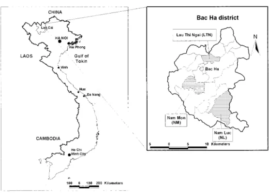
We selected Bac Ha district, Lao Cai province, as the study area because we found most intensive slope land agriculture here in the mountainous region of Northern Vietnam (Fig. 1). Bac Ha is an upland district with elevation ranging between 100 to 1,500 m a.s.l. It is adja-cent to Si Ma Cai district to the north and approximately 20 km south of the border with China. Bac Ha district has 20 communes and one town subdivided into 213 villages. The total population of the district is 45,982, of which 22,667 are women, and 39,285 are ethnic minority people. The population density is 64 persons per square km. There are 17 ethnic groups, with H’mong accounting for 40 percent of the population. The natural area of Bac Ha district is 68,678 ha, of which 12,442 ha is agricultural land (accounting for 18.1 percent), forest land is 19,101 ha (27.8 percent), and unused land is about 36,232 ha (52.7 percent). The average elevation is 1,000 m (the highest peak is 1,532 m). According to Koppen’s clas-sification, this climate is tropical monsoon with dry and cool winter. The average rainfall is 1,800 mm per year and the average temperature is 18.3˚C (semi-temperate or subtropical cli-mate). The main agricultural crops are upland rice, paddy rice, and maize. Several other crops such as cassava, tea, and soybean are also cultivated in a small scale [HEDO 2001].
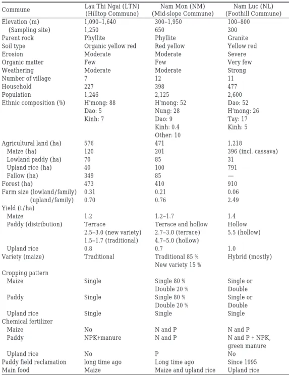
Three communes, Lau Thi Ngai, Nam Mon, and Nam Luc located at approximately 104˚ 25' E and 22˚ 30' N were selected for study in Bac Ha district. Three communes are located within 12 km (west to east) and 18 km (north to south) distance with each other in the steep mountainous region. Selected information on three communes is shown in Table 1. Lau Thi Ngai village is located on the top of the hill and has the highest elevation and coolest climate (hilltop commune). Nam Mon is located on the middle of the slope and has intermediate ele-vation (mid-slope commune). Nam Luc is located along the river at the lowest part of the mountainous region with a warmer local climate than the other two (foothill commune).
Parent materials in the hilltop commune and mid-slope commune are phyllite, which results in soil with a fine clayey nature. In the foothill commune, the parent material is gran-ite, which results in soil with a very sandy, acidic nature resulting in poor soil fertility. Soil types by the Vietnamese soil classification map (1978) are allocated as Organic yellow-red soils on weathered rocks (hilltop commune), Red-yellow soils on weathered rocks (mid-slope commune), and Yellow-red soils (foothill commune). Due to shallow soil layers (30–50 cm) with a weak development of the B horizon in hilltop and mid-slope communes, the soils could be classified as Typic Dystropepts with some Typic Hapludults by the U.S. Soil Taxonomy [Soil Survey Staff 1992]. On the other hand, in the foothill commune, though out-crops of granite are found on sloping land everywhere, soil depth is often deeper than 1 m. Clay accumulation and the development of the B horizon is weak. Therefore, Typic Dystropepts and Typic Hapludults could be appropriate.
SAKURAIK. et al.: Impact of Agricultural Practices on Soils of Northern Vietnam
Commune Lau Thi Ngai (LTN) Nam Mon (NM) Nam Luc (NL)
(Hilltop Commune) (Mid-slope Commune) (Foothill Commune)
Elevation (m) 1,090–1,640 300–1,950 100–800
(Sampling site) 1,250 650 300
Parent rock Phyllite Phyllite Granite
Soil type Organic yellow red Red yellow Yellow red
Erosion Moderate Moderate Severe
Organic matter Few Few Very few
Weathering Moderate Moderate Strong
Number of village 7 12 11
Household 227 398 477
Population 1,246 2,125 2,600
Ethnic composition (%) H’mong: 88 H’mong: 52 Dao: 52
Dao: 5 Nung: 28 H’mong: 26
Kinh: 7 Dao: 9 Tay: 17
Kinh: 0.4 Kinh: 5
Other: 10
Agricultural land (ha) 576 471 1,218
Maize (ha) 120 201 396 (incl. cassava)
Lowland paddy (ha) 70 85 31
Upland rice (ha) 40 100 791
Fallow (ha) 349 85 —
Forest (ha) 473 410 910
Farm size (lowland/family) 0.31 0.21 0.06
(upland/family) 0.70 0.76 2.49
Yield (t/ha)
Maize 1.2 1.2–1.7 1.4
Paddy (distribution) Terrace Terrace and hollow Hollow 2.5–3.0 (new variety) 2.7–3.0 (terrace) 5.5 (hollow) 1.5–1.7 (traditional) 4.7–5.0 (hollow)
Upland rice 0.8 0.7 1.0
Variety (maize) Traditional Traditional 85 % Hybrid (mostly)
New variety 15 % Cropping pattern
Maize Single Single 80 % Single or
Double 20 % Double
Paddy Single Single 80 % Single or
Double 20 % Double
Upland rice Single Single Single
Chemical fertilizer
Maize No N and P N and P
Paddy NPK+manure N and P N and P + NPK,
green manure
Upland rice No P No
Paddy field reclamation long time ago Long time ago Since 1995
Main food Maize Maize and upland rice Upland rice
II–2 Soil Samples and Analytical Methods
Soil survey points in each commune were selected from every representative land use and from natural forests. The number of the investigated pedons was 6 in the hilltop commune (2 forest, 2 maize, 1 upland paddy, and 1 lowland paddy), 6 in the mid-slope commune (1 for-est, 1 forest fallow, 1 maize, 2 upland paddy, and 1 lowland paddy), and 5 in the foothill com-mune (1 forest, 1 fallow, 1 cassava, 1 upland paddy, 1 lowland paddy). Soil samples were col-lected from surface and subsurface horizons. Mostly surface soils (A or Ap horizon) were collected at the depth of 0 to 20 cm from the upland field, 0 to 10 cm from the paddy field in the terrace, and 0 to 5 cm from the forest. Subsurface soils were collected beneath this depth at approximately 20 cm interval. Soil samples were air-dried and crushed to pass through a sieve with a 2 mm mesh.
The pH in water and 1 M KCl solution was measured by the glass electrode methods, at the soil: solution ratio of 1 : 2.5 and designated as pHw and pHK hereafter. Exchangeable H was extracted with 1 M KCl for 1 h and determined with the titration method (designated as ExH). Exchangeable cations were extracted twice with 1 M ammonium acetate at pH 7.0, and the concentration of Ca, Mg, and K (designated as ExCa, ExMg, and ExK) was mea-sured by atomic absorption spectrophotometer (Shimadzu, AA-610S). The ammonium ion absorbed in the residue was replaced by 10 percent NaCl and determined with distillation and titration methods as cation exchange capacity (CEC). Available phosphorus was mined by the Olsen method (designated as AvP). Organic matter (OM) content was deter-mined by the Walkley-Black method. Soil samples were digested by HNO3-H2SO4 and the contents of N, P, K were determined by distillation- titration method for N, spectrophotome-try for P, AAS for K, respectively (designated as TN, TP, TK). Soil texture was determined by the pipet method. Water dispersible clay and silt contents were measured by the pipet method after 4 h reciprocal shaking at the soil to water ratio of 10 g to 1 L. Al and Fe oxides and hydroxides were extracted twice with an acid ammonium oxalate solution (0.2 M, pH 3.0) by reciprocal shaking in the dark for 1 h, at a soil to solution ratio of 1 to 25 [Mckeague and Day 1966]. They were extracted twice with a citrate-bicarbonate mixed solution buffered at pH 7.3 with the addition of sodium dithionite for 15 min. at 75 to 80˚C, using a soil to solu-tion ratio of 1 to 100 [Mehra and Jackson 1960]. Al and Fe contents in the extract were des-ignated as Alo and Feo for the former extractant, and Ald and Fed for the latter. The con-tents of Al and Fe were determined using a sequential plasma spectrometer (Shimadzu, ICPS-1000IV). Clay minerals were identified by X-ray diffraction method (Shimadzu, XD-D1w). The point of zero charge equivalent as point of zero salt effect (PZSE) and σp (resid-ual charge at the pH of PZSE) was determined by the modified salt titration method (STPT method) [Sakurai et al. 1988].
SAKURAIK. et al.: Impact of Agricultural Practices on Soils of Northern Vietnam
III Results and Discussion
III–1 Agriculture Conditions in the Communes Investigated
Comparison among the three communes is summarized in Table 1, although some informa-tion still remains unknown. Each commune is composed of different ethnic groups. The H’mong generally occupy the higher land, the Dao occupy the lower land, and several other groups are mixed with them. Compared with the agricultural land, forest area is 20 percent smaller than the agricultural land in each commune. Among agricultural land, maize cultiva-tion area is the largest in hilltop and mid-slope communes, followed by lowland paddy area in the hilltop commune and upland rice area in the mid-slope commune. On the other hand, upland rice field is the largest, followed by maize and smaller area of paddy in the foothill commune.
Agricultural land area is the largest in the foothill commune, where they mostly depend on shifting cultivation. Lowland paddy cultivation was initiated in 1995. They have not felt the strong necessity for intensive management of their agricultural land, such as terracing to prevent against soil erosion, having a more favorable climate than the other communes. Even though the average farm size is the largest among the three communes, 2.49 ha of upland field and 0.06 ha of lowland field per family, shifting cultivation with long-term fallow is impossible due to limited land availability. In addition to rice for home consumption, they also produce maize and cassava for sale because of the easy access to the main road. They used a hybrid variety of maize to get higher yield. Double cropping of upland rice and maize is not common, probably due to the poor soil conditions and less water availability in the dry season.
The hilltop commune makes beautiful terraces to produce every crop. Along the valley, they have constructed lowland paddy fields, while they produce both maize and upland rice on the slopes. The width of the terrace is very narrow, generally 2 to 5 m along the slope, while along the valley it is much wider, depending on the topography. Terraces have been introduced since before their grand father’s generation, probably based on technology trans-fer from China. The average farm size is 1 ha, of which 70 percent is upland and 30 percent is lowland. Small farm size was thought to accelerate terrace making in order to shift their farming from slash and burn agricultural system to continuous cultivation. Since the hilltop commune is located at an elevation of 1,250 m, crop yields are lower than in the foothill com-mune due to cooler climate. The cropping pattern is single cropping. Since the use of chemi-cal fertilizer is still limited, the yield of maize and lowland paddy is not high.
The mid-slope has an intermediate nature of farm size, cropping pattern, and main food. The width of terrace is also wider than that in the hilltop commune. The wider variation of ethnic groups and their different food habits may affect these farming practices. Their typi-cal land use is contour planting, and therefore, the intensity of land management can be con-sidered intermediate.
Assuming that one person (adult) needs 2,500 kcal per day and all the consumption calo-ries are obtained from rice, rice will be necessary in an amount of 0.325 t per person per year [Watanabe et al. 2003]. To support the population in the foothill commune, where 2,600 persons live (Table 1), approximately 845 t of rice is necessary. The total harvested amount of upland rice can be calculated as 791 t (791 ha ×1.0 t/ha). This amount is, therefore, slightly lower than the demand. Supplementary rice will come from the lowland paddy where the total amount of rice, (31 ha ×5.5 t/ha = 170.5 t), is produced. Total amount is slightly higher than demand and they may eat some maize also. This calculation leads us to conclude that if the population continues to increase, they will not be able to support them-selves in the future. To increase the yield of crops by intensive cropping management is indispensable for their subsistence. Otherwise, they have to open new land in the forest, which will easily lead to a degradation of their local ecosystem within a short term. Thus, it can be predicted that they will soon start more intensive management of their land, and ter-racing must be one promising method for soil protection. Other type of cash crops using tree species such as fruits or cardamom may be another way to get more cash income to buy rice or maize for the subsistence.
III–2 Soil Properties
Chemical, physical, and mineralogical properties of the soils are shown in Tables 2 to 4, where averaged values for soils from forests and crop fields are also included. Original soil properties before utilized for agricultural purpose are best represented in the forest soils. When the parent materials of soils were rather similar, the magnitude of cation exchange capacity (CEC) could be one of the indicators of weathering. Upon weathering, CEC value becomes smaller due to loss of the active exchange site for cation retention. The CEC value reflects the sum of negative charges on soil particles arising from both organic matter and clay minerals together with oxides and hydroxides of Si, Fe, and Al. On the other hand, the amount of Fed becomes higher as a result of relative accumulation of Fe compared with other elements during weathering. Al and Fe oxides and hydroxides would be more crystal-lized upon weathering due to loss of active hydroxyl groups, then Alo/Ald and Feo/Fed ratios become smaller, and eventually fell to a value less than 0.10. At the ultimate weather-ing condition, these values would become less than 0.01. In addition, point of zero salt effect (PZSE) value becomes higher reflecting on the relative accumulation of oxides and hydrox-ides of Fe and Al. Other soil properties, such as the amount of exchangeable cations, avail-able phosphorus, and organic matter, fluctuate easily with agricultural activities. Clay con-tent will increase with weathering in the soils if there is no occurrence of soil erosion. However, on sloping land, soil erosion occurs continuously in the long term. Thus, it is rather difficult to utilize this value to discuss the weathering status of soils.
Based on these indicators, the weathering status of soils in the three communes can be interpreted as follows. Soils in the hilltop commune show the highest value of CEC with a highest amount of organic matter. Fed values were also highest. On the other hand, soils in
511
S
AKURAI
K.
et al
.: Impact of Agricultural Practices on Soils of Northern Vietnam
Items* pHw pHK CEC ExH ExK ExCa ExMg ExSum OM TN TK
Soil Name** LTN-Fr1 A 4.4 4.1 24.59 1.30 0.42 7.20 1.80 9.42 6.93 0.350 1.45 B1 4.6 4.4 11.09 2.85 0.17 1.62 0.18 1.97 1.80 0.130 1.37 B2 4.6 4.4 10.46 3.10 0.14 1.44 0.36 1.94 1.42 0.102 1.45 LTN-Fr2 A1 4.2 3.9 20.27 7.41 0.32 1.44 0.36 2.12 5.29 0.261 0.84 B 4.1 3.9 14.77 7.28 0.11 0.90 0.18 1.19 2.84 0.127 0.78 Ave. 4.4 4.1 16.24 4.39 0.23 2.52 0.58 3.33 3.66 0.194 1.18 LTN-M1 Ap 5.0 4.7 11.82 0.16 0.32 3.60 1.80 5.72 2.05 0.105 1.54 B1 5.4 5.3 6.82 0.09 0.14 2.70 0.90 3.74 0.70 0.075 1.72 B21 5.5 5.3 8.31 0.09 0.13 2.88 1.62 4.63 0.50 0.063 1.54 B22 5.7 5.5 22.15 0.09 0.11 2.16 1.80 4.07 0.70 0.065 1.84 LTN-Fa A/B1 4.7 4.4 7.41 0.90 0.12 2.16 0.54 2.82 1.47 0.110 1.65 B2 4.6 4.4 11.09 2.85 0.17 1.62 0.18 1.97 1.80 0.130 1.37 B3 4.7 4.4 6.14 0.84 0.11 1.26 0.18 1.55 0.83 0.081 1.73 LTN-M2 0–20 4.2 4.0 19.74 5.95 0.40 1.80 0.90 3.10 4.80 0.225 0.77 20–40 4.1 3.9 14.30 5.92 0.39 1.44 0.36 2.19 3.13 0.139 0.87 LTN-Up Ap1 4.0 3.8 20.52 7.38 0.25 1.80 0.36 2.41 5.68 0.267 0.98 Ap2 4.1 3.9 20.07 7.62 0.16 1.44 0.36 1.96 4.60 0.225 0.94 B1 4.1 3.9 16.09 7.19 0.10 0.72 0.18 1.00 2.30 0.120 0.84 B2 4.2 4.0 15.67 6.29 0.10 0.72 0.36 1.18 2.45 0.160 0.97 B3 4.3 4.0 13.24 5.85 0.08 0.90 0.18 1.16 1.66 0.090 0.82 LTN-P Ap1 4.6 4.5 15.82 0.12 0.13 7.74 0.36 8.23 3.08 0.145 1.07 Ap2 5.0 5.0 16.08 0.09 0.09 9.00 0.90 9.99 2.35 0.121 1.15 B 4.7 4.6 14.91 1.05 0.11 5.04 2.16 7.31 1.57 0.105 1.09 Ave. 4.6 4.4 14.13 3.09 0.17 2.76 0.77 3.71 2.33 0.131 1.23
TP AvP Clay Silt Sand WDC WDS Alo Fed AloAld FeoFed PZSE σp 0.25 11.2 19.5 19.3 61.2 2.2 5.6 n.d. n.d. n.d. n.d. 4.32 2.14 0.20 2.2 24.8 26.9 48.3 0.3 17.0 n.d. n.d. n.d. n.d. 4.19 0.83 0.22 3.2 22.6 24.4 53.0 2.2 8.3 n.d. n.d. n.d. n.d. 4.39 0.53 0.22 9.5 30.9 16.0 53.2 1.2 26.3 0.4 3.13 0.52 0.23 4.14 1.33 0.17 2.0 17.6 33.6 48.9 3.6 8.2 0.2 3.33 0.28 0.09 4.35 0.45 0.21 5.6 23.1 24.0 52.9 1.9 13.1 0.3 3.23 0.40 0.16 4.28 1.06 0.29 7.9 24.6 22.7 52.7 2.1 27.9 0.1 3.05 0.30 0.12 4.58 1.90 0.12 3.9 21.3 28.5 50.3 1.9 10.6 0.1 3.57 0.10 0.03 5.52 0.45 0.20 2.9 20.5 32.6 47.0 0.9 6.4 0.0 3.63 0.07 0.02 5.42 0.50 0.22 2.8 15.8 34.1 50.1 3.6 4.2 0.1 3.74 0.12 0.04 6.13 0.10 0.15 4.4 24.3 22.9 52.8 3.9 29.8 n.d. n.d. n.d. n.d. 4.47 0.71 0.20 2.2 26.9 24.9 48.3 1.9 11.9 n.d. n.d. n.d. n.d. 4.70 0.38 0.12 3.9 29.8 20.4 49.8 0.3 13.1 n.d. n.d. n.d. n.d. 4.81 0.00 0.20 5.1 38.0 15.1 46.9 0.5 31.5 n.d. n.d. n.d. n.d. 3.88 2.00 0.17 2.5 40.5 17.6 41.9 0.3 29.2 n.d. n.d. n.d. n.d. 4.20 0.28 0.26 6.1 42.4 15.0 42.6 2.7 41.3 0.3 2.96 0.36 0.17 4.08 2.00 0.20 9.6 42.5 13.3 44.2 1.6 32.5 0.3 2.53 0.41 0.20 4.11 1.58 0.21 5.4 49.4 12.7 37.9 1.8 45.6 0.3 3.83 0.34 0.13 4.22 0.53 0.17 2.8 48.8 12.8 38.3 1.4 31.8 0.3 3.26 0.30 0.10 4.32 0.46 0.21 4.5 48.0 12.6 39.4 0.8 31.2 0.2 3.76 0.19 0.06 4.37 0.45 0.20 2.8 43.0 15.4 41.6 2.5 49.2 0.1 3.22 0.16 0.10 4.69 3.85 0.17 2.2 41.8 17.2 41.0 1.8 37.9 0.1 3.29 0.14 0.07 4.12 5.69 0.12 2.0 47.9 11.6 40.5 2.0 51.9 0.1 3.49 0.17 0.06 4.17 5.08 0.19 4.2 35.6 19.4 45.0 1.8 28.6 0.2 3.36 0.22 0.09 4.58 1.53 ―――― cmol (+) kg-1 ―――― ―――― g kg-1 ―――― ―――――――― % ―――――――― cmol (+) kg-1
* pHw and pHK: pH measured in water and KCl solution; CEC: cation exchange capacity; ExH, K, Ca, Mg: Exchangeable H, K, Ca, Mg; Ex Sum: sum of exchangeable K, Ca, and Mg; OM: organic matter; TN, TK, TP: total nitrogen, pottasium, phosphorus; AvP: available phosphorus; WDC: water dispersible clay; WDS: water dispersible silt; Alo: Al extracted by acid oxalate; Fed: Fe extracted by DCB treatment; AloAld, FeoFed: ratio of Alo/Ald andFeo/Fed; PZSE: point of zero salt effect; σp: residual charge at PZSE
** Fr forest; Fa: fallow; M: maize; C: cassava; P: paddy; Up: upland paddy
東南アジア研究
41
巻4号
Items* pHw pHK CEC ExH ExK ExCa ExMg ExSum OM TN TK
Soil Name** NM-Fr A 4.3 4.1 12.18 1.41 0.25 0.72 1.08 2.05 3.18 0.150 1.41 B 4.3 4.1 9.45 1.24 0.16 0.90 0.18 1.24 2.10 0.110 1.24 Ave. 4.3 4.1 10.82 1.33 0.21 0.81 0.63 1.65 2.64 0.130 1.33 NM-M Ap 5.1 5.0 10.18 0.18 0.19 4.50 0.90 5.59 2.45 0.140 1.56 B1 4.8 4.6 7.86 0.81 0.24 1.80 0.90 2.94 0.93 0.080 1.74 B2 4.8 4.6 5.53 0.62 0.06 0.90 0.90 1.86 0.73 0.060 1.93 NM-Fa A 4.2 4.0 13.15 7.78 0.14 0.72 0.18 1.04 3.82 0.180 1.22 B 4.3 4.0 11.50 1.23 0.17 0.54 0.18 0.89 2.45 0.120 1.23 NM-Up1 Ap1 4.2 4.0 13.40 1.33 0.29 0.90 0.10 1.29 4.16 0.210 1.33 Ap2 4.3 4.1 14.92 1.21 0.24 1.08 0.10 1.42 4.36 0.230 1.21 B 4.2 4.0 10.09 4.68 0.11 0.54 0.36 1.01 3.03 0.120 1.43 NM-Up2 Ap 4.0 3.8 13.39 4.77 0.27 0.72 0.18 1.17 4.16 0.200 1.55 Bt 4.1 3.8 14.69 5.52 0.24 0.72 0.10 1.06 4.01 0.190 1.33 B1 4.3 4.0 11.74 5.11 0.18 0.72 0.18 1.08 2.45 0.140 1.29 B2 4.2 4.1 10.97 4.71 0.15 0.90 0.18 1.23 2.30 0.120 1.34 NM-P1(0–8cm) 4.4 4.3 12.58 1.52 0.16 2.34 0.90 3.40 4.60 0.240 1.73 2(8–23) 4.4 4.3 9.24 1.21 0.08 2.70 0.36 3.14 2.84 0.140 1.65 3(23–37) 4.5 4.4 6.76 1.30 0.06 1.62 0.18 1.86 1.76 0.090 1.69 4(37–80) 4.5 4.3 6.45 1.95 0.06 1.26 0.54 1.86 1.22 0.070 1.65 5(80–100) 4.0 4.0 18.94 7.53 0.05 1.80 3.50 5.35 1.20 0.070 1.48 Ave. 4.4 4.2 11.26 3.03 0.16 1.40 0.57 2.13 2.73 0.141 1.49
TP AvP Clay Silt Sand WDC WDS Alo Fed AloAld FeoFed PZSE σp 0.22 1.9 34.2 13.2 52.6 3.1 27.7 0.2 2.44 0.40 0.18 4.10 1.06 0.10 3.9 37.8 13.0 49.2 1.2 10.9 0.2 3.01 0.33 0.15 4.21 0.50 0.16 2.9 36.0 13.1 50.9 2.2 19.3 0.2 2.73 0.37 0.17 4.16 0.78 0.20 3.1 30.4 14.6 55.1 2.4 62.4 0.2 3.20 0.30 0.10 3.95 3.74 0.12 3.1 24.7 15.2 60.1 1.5 22.2 0.1 3.37 0.13 0.05 4.60 0.47 0.15 2.8 23.9 16.0 60.2 1.5 14.9 0.0 3.50 0.12 0.03 4.76 0.41 0.17 6.4 43.5 12.3 44.2 1.7 48.5 n.d. n.d. n.d. n.d. 4.12 0.44 0.12 3.1 45.4 9.9 44.6 1.1 31.2 n.d. n.d. n.d. n.d. 3.73 1.65 0.17 7.2 47.0 12.1 40.9 0.3 45.7 0.2 3.21 0.40 0.15 4.14 0.26 0.15 5.7 48.8 11.6 39.6 1.6 24.6 0.2 6.80 0.18 0.07 4.09 0.52 0.19 3.9 48.4 12.9 38.7 1.5 39.4 0.2 5.18 0.22 0.06 4.21 0.24 0.20 5.4 46.9 12.2 40.9 1.0 55.5 n.d. n.d. n.d. n.d. 4.41 0.05 0.20 5.4 32.9 15.4 51.7 1.5 43.8 n.d. n.d. n.d. n.d. 4.02 1.17 0.17 3.1 26.7 36.3 36.9 1.1 16.9 n.d. n.d. n.d. n.d. 4.30 0.11 0.10 1.4 46.3 12.3 41.4 0.6 30.8 n.d. n.d. n.d. n.d. 4.15 0.54 0.17 3.2 19.8 34.2 45.9 3.5 40.4 0.2 1.13 0.82 0.32 4.07 2.33 0.15 5.4 20.7 29.9 49.5 11.1 49.1 0.2 1.09 0.85 0.32 4.33 1.36 0.17 3.6 13.1 18.7 68.1 4.6 49.2 0.1 0.72 0.81 0.19 4.12 1.00 0.11 4.5 21.0 23.2 55.8 9.8 63.3 0.2 1.19 0.77 0.14 4.32 0.55 0.11 9.8 7.4 10.0 82.5 12.5 24.1 0.1 0.12 2.63 1.99 2.56 3.20 0.16 4.5 32.2 17.5 50.4 3.4 38.9 0.2 2.68 0.66 0.31 4.11 1.06 ―――― cmol (+) kg-1 ―――― ―――― g kg-1 ―――― ―――――――― % ―――――――― cmol (+) kg-1 *,**: See Table 2
513
S
AKURAI
K.
et al
.: Impact of Agricultural Practices on Soils of Northern Vietnam
Items* pHw pHK CEC ExH ExK ExCa ExMg ExSum OM TN TK
Soil Name** NL-Fr A1 4.6 4.5 11.72 3.04 0.96 1.44 0.18 2.58 6.02 0.298 0.81 A2 4.0 4.0 9.44 3.04 0.25 0.90 0.10 1.25 3.30 0.166 0.88 B1 4.4 4.2 8.93 2.79 0.14 1.80 0.90 2.84 2.35 0.115 0.95 B2 4.4 4.2 6.29 3.04 0.19 0.54 0.36 1.09 2.20 0.110 0.87 BC 4.4 4.2 6.49 2.69 0.17 0.54 0.27 0.98 1.76 0.103 0.84 Ave. 4.4 4.2 8.57 2.92 0.34 1.04 0.36 1.75 3.13 0.158 0.87 NL-Fa A1 4.5 4.5 8.31 1.27 0.30 2.16 0.36 2.82 2.98 0.138 0.72 A2 4.5 4.5 7.09 1.95 0.18 1.08 0.36 1.62 2.15 0.112 0.77 B 4.4 4.4 5.71 2.42 0.14 0.90 0.10 1.14 1.76 0.095 0.79 NL-C Ap 5.4 5.4 12.00 0.00 0.45 7.74 2.16 10.35 3.52 0.169 1.08 Ap1 4.6 4.4 11.47 0.93 0.35 2.88 2.16 5.39 2.84 0.138 0.79 Ap2 4.5 4.3 9.60 1.67 0.28 2.88 0.36 3.52 2.84 0.137 0.78 B1 4.5 4.3 8.71 2.14 0.18 1.44 0.72 2.34 3.82 0.192 0.87 B2 4.5 4.4 8.92 2.14 0.14 1.44 1.26 2.84 1.47 0.106 0.82 B3 4.6 4.5 8.87 1.79 0.14 1.26 1.98 3.38 1.22 0.093 0.83 NL-P Ap1 4.8 4.5 5.97 0.52 0.16 1.44 0.36 1.96 2.45 0.121 0.68 Ap2 4.8 4.5 7.86 0.25 0.30 2.52 0.72 3.54 2.50 0.125 0.58 AB 4.5 4.4 7.56 0.99 0.22 1.08 0.72 2.02 1.76 0.105 0.68 B2 4.5 4.4 5.94 1.42 0.13 1.08 0.72 1.93 1.32 0.103 0.69 B2 4.5 4.3 5.68 1.70 0.08 0.90 0.10 1.08 0.98 0.094 0.61 B3 4.5 4.3 5.87 1.61 0.09 1.08 0.10 1.27 1.07 0.076 0.75 NL-Up Ap1 4.6 4.2 12.03 0.40 0.56 4.50 0.90 5.96 3.62 0.162 0.87 Ap2 4.6 4.5 9.52 2.17 0.32 1.44 0.18 1.94 2.89 0.137 0.95 AB 4.5 4.3 8.42 2.69 0.18 1.08 1.08 2.34 1.96 0.101 0.96 B1 4.0 4.0 8.60 2.32 0.12 1.62 0.72 2.46 1.50 0.080 0.91 B2 4.5 4.3 10.94 1.98 0.13 2.70 3.14 5.97 0.80 0.069 0.89 Ave. 4.6 4.4 8.45 1.52 0.22 2.06 0.91 3.19 2.17 0.118 0.80
TP AvP Clay Silt Sand WDC WDS Alo Fed AloAld FeoFed PZSE σp 0.17 7.2 38.3 11.1 50.6 1.6 21.1 0.2 0.78 0.68 0.49 4.22 1.20 0.12 3.6 33.0 10.8 56.2 1.3 34.0 0.2 0.98 0.76 0.20 4.28 0.56 0.10 3.5 34.2 10.2 55.6 1.0 28.8 0.2 0.88 0.72 0.19 4.24 0.50 0.12 3.6 35.8 10.3 53.9 2.9 54.9 0.1 0.88 0.63 0.15 4.26 0.50 0.10 4.1 35.5 11.7 52.8 1.0 41.7 0.1 0.81 0.53 0.08 3.67 1.71 0.12 4.4 35.4 10.8 53.8 1.6 36.1 0.2 0.87 0.66 0.22 4.13 0.89 0.12 5.7 22.9 11.4 54.5 1.5 26.3 n.d. n.d. n.d. n.d. 4.15 1.66 0.10 3.3 24.8 11.5 63.7 2.5 137.1 n.d. n.d. n.d. n.d. n.d. n.d 0.08 3.5 26.9 11.0 62.0 0.4 55.0 n.d. n.d. n.d. n.d. n.d. n.d. 0.12 3.5 17.2 14.1 68.7 1.6 9.7 0.1 0.52 0.94 0.24 4.17 1.24 0.17 3.3 28.4 16.3 55.3 1.3 23.1 n.d. n.d. n.d. n.d. 4.35 0.72 0.17 4.1 31.6 15.2 53.2 0.3 20.2 n.d. n.d. n.d. n.d. 4.19 0.57 0.15 3.4 31.9 13.5 54.7 0.7 32.8 n.d. n.d. n.d. n.d. 4.33 0.57 0.15 3.0 34.6 13.9 51.4 1.2 38.4 n.d. n.d. n.d. n.d. n.d. n.d. 0.17 3.6 40.0 12.8 47.2 2.2 38.1 n.d. n.d. n.d. n.d. n.d. n.d. 0.15 3.4 17.9 9.9 72.1 3.8 54.4 0.1 0.81 0.48 0.28 n.d. n.d. 0.15 3.2 19.7 10.0 70.3 3.4 45.5 0.1 0.70 0.69 0.37 4.59 1.31 0.08 3.0 21.6 11.0 67.4 0.6 21.4 0.1 0.92 0.47 0.17 4.15 0.88 0.10 1.5 24.8 9.7 65.5 3.4 46.0 0.1 0.92 0.44 0.10 n.d. n.d. 0.12 5.4 30.3 16.8 52.9 2.5 38.2 0.1 0.79 0.53 0.10 n.d. n.d. 0.10 4.9 37.8 2.8 59.4 1.5 142.9 0.1 1.07 0.49 0.06 4.50 0.46 0.12 9.2 21.5 22.2 56.3 1.6 9.4 0.1 0.89 0.82 0.21 n.d. n.d. 0.10 4.9 31.6 13.0 55.3 0.6 23.9 0.1 0.39 1.74 0.48 n.d. n.d. 0.08 4.7 37.1 12.6 50.2 1.7 42.6 0.1 1.62 0.41 0.09 n.d. n.d. 0.08 3.9 43.8 12.2 44.0 1.0 38.7 0.1 3.13 0.22 0.03 4.32 0.33 0.09 3.9 31.8 12.5 55.7 2.3 15.9 0.1 1.28 0.63 0.06 4.49 0.46 0.12 4.1 28.8 12.6 58.0 1.7 43.0 0.1 1.09 0.66 0.18 4.32 0.82 ―――― cmol (+) kg-1―――― ―――― g kg-1―――― ―――――――― % ―――――――― cmol (+) kg-1 *,**: See Table 2
the foothill commune show the lowest value of CEC with the lowest amount of organic mat-ter (OM), especially in the crop field. The amount of Fed is lower than the other communes. Therefore, the weathered soil from granite in the foothill commune could be considered less fertile due to the acidic nature of the parent materials. Even though the soil fertility in the foothill commune was the lowest, the major agricultural practice was shifting cultivation, the least intensive agricultural method in the mountainous region. This disadvantage is thought to be compensated by the relatively higher temperature due to the lowest elevation among three communes, as described in the previous section.
The ratios for water dispersible clay to completely dispersed clay (WDC) were ex-tremely low throughout the sites examined even though the clay content varied greatly among the communes and within each commune. Among them, WDC was the lowest in the hilltop commune (maximum value of 3.6 in the subsoil of the forest). Only the paddy field of the mid-slope commune (NM-P) showed a little higher value than the others. This might be proof that the clays with a higher WDC were accumulated in the paddy field in the valley, since clay fractions with a high dispersibility were prone to be eroded in the course of heavy rain and moved away from the slope land down to the paddy field.
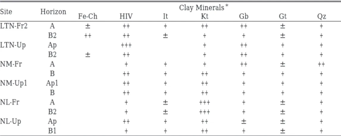
Clay mineral composition in the mid-slope commune (Table 5) showed the presence of hydroxyl-interlayered vermiculite (HIV) together with kaolins followed by illite. The HIV is one of the resistible clays against water dispersion. Among the clay minerals found here, illite is most easily dispersed [Itami and Kyuma 1995]. However, the relative abundance of illite for all soils examined was not significantly high. Thus, soil erodibility in this region was not considered high even though the slope in the field was steep enough for erosion. In addition, the value of pH measured in water (pHw) was low enough to prevent soil disper-sion, which allowed exchangeable Al ions to neutralize the negative charge of clays arising from isomorphous substitution [ibid.]. Larger negative charge induces more repulsion of
Clay Minerals* Site Horizon Fe-Ch HIV It Kt Gb Gt Qz LTN-Fr2 A ± ++ + ++ ++ ± + B2 ++ ++ ± + + ± + LTN-Up Ap +++ + ++ + + B2 ± ++ + ++ + + NM-Fr A + + + ++ ± ++ B ++ + ++ + + + NM-Up1 Ap1 ++ + ++ + + + B ++ + ++ + + + NL-Fr A + ± +++ + ± + B2 + ± +++ + ± + NL-Up Ap ++ + ++ ± ± + B1 + + ++ + ± +
Table 5 Clay Mineral Composition in Each Commune
*Fe-Ch, Fe-chrolite; HIV, hydroxyl-interlayered vermiculite; It, Illite; Kt, Kaolins; Gb, Gibbsite; Gt, Goethite; Qz, Quartz
SAKURAIK. et al.: Impact of Agricultural Practices on Soils of Northern Vietnam
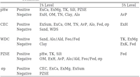
1% Level 5% Level
pHw Positive ExCa, ExMg, TK, Silt, PZSE
Negative ExH, OM, TN, Clay, Alo AvP
CEC Positive ExSum, ExCa, OM, TN, AvP, Alo, Fed,σp ExH Negative Sand, WDS
WDC Positive Sand, Alo/Ald, Feo/Fed TK, ExMg
Negative Clay ExK, Fed
PZSE Positive pHw, TK, Silt Fed
Negative OM, ExH, AvP, Alo/Ald, Feo/Fed,σp σp Positive CEC, ExCa, ExMg, ExSum
Negative PZSE
Table 6 Major Correlations among Soil Properties with a Significant Correlation Coefficient
clay particles, and leads to more dispersion of clays.
Only the subsurface layer of forest soils in the hilltop commune retained a significant amount of Fe-chrolite and HIV, and lesser amounts of kaolins. Since gibbsite is accumulated as a proof of the presence of abundant exchangeable aluminum reflecting highly acidic soil properties, the soils in the hilltop commune are potentially more acidic than others. Also, soils here were not ultimately weathered as mentioned before. A cooler climate due to high-er elevation would keep the soils younghigh-er against sevhigh-ere weathhigh-ering. On the othhigh-er hand, in the mid-slope and foothill communes, relative abundance of kaolins was higher than in hill-top commune. Since kaolins were one of the most inactive clays physico-chemically (low activity clay) with the other constituents of soils, CEC values of mid-slope and foothill com-munes were also lower than those of the hilltop commune. Therefore, based on the clay min-eral composition, cooler climate in the higher elevation was most influential factor for soil genesis in the mountainous region under the subtropical climate.
Table 6 summarizes the results of correlation analysis using soil parameters in Tables 2 to 4 on chemical, physical, and mineralogical properties. The pHw value was positively cor-related with alkaline earth elements (ExCa and ExMg) and negatively with acidity (ExH), organic matter (OM and TN), clay content, and amorphous aluminum content (Alo). This trend was commonly found in natural soils. These findings indicate that agricultural prac-tices, including fertilization did not affect the soil properties greatly. CEC was correlated positively with amount of nutrients held by soils (ExSum and ExCa), organic matter (OM and TN) and available phosphorus (AvP), accumulation of Al and Fe (Alo and Fed). Although the amount of crystallized clay minerals with permanent charges could not be quantified, the magnitude of permanent negative charge could be estimated by that of σp. The magnitude ofσp could be considered as the actual amount of permanent negative charge revealed at the field condition [Sakurai et al. 1988]. Theσp value reflects the amount of permanent negative charge and also OM [Sakurai et al. 1989]. Thus the linear correlation
betweenσp and OM is not always high. Since most of the nutritional elements such as Ca, Mg, K, and NH4 are retained by the permanent negative charge, high correlation between CEC and Fe or Al oxides and hydroxides shows the relative importance of them as sources of variable charge. This is one of the proofs for the dominance of strongly weathered soils [ibid.]. Positive correlation of the 5 percent significant level between CEC and exchangeable H (ExH) indicated the presence of permanent negative charges arising from crystalline losilicates such as HIV and illite in Table 5. Nonetheless, the dominance of crystalline phyl-losilicates could not be found, and therefore, strongly weathered nature of the soils here controls the nutrient retention. Although the WDC was correlated with some soil properties, WDC value itself was quite small and less important. The value of PZSE was correlated nega-tively with OM content, the magnitude of permanent negative charge, exchangeable alu-minum, and crystalline Si oxides and positively with oxides and hydroxides of Al and Fe [Sakurai 1990]. Since the Alo/Ald and Feo/Fed become lower upon weathering as men-tioned before, negative correlation between PZSE and these two ratios indicate that the soils here were in the various weathered condition. In addition, PZSE values around 4.0–4.5 and Feo/Fed values more than 0.1 indicate that the soils studied were in the process of strong weathering but had not yet reached the level of the ultimately weathered soils.
IV Conclusions
IV–1 Fertility
Soil pH was lower than 5.0 showing strong acidity. Only maize plantations showed a higher soil pH of more than 5.0 probably due to liming. CEC values in the foothill commune and some part of mid-slope commune were around 12 (cmol(+) kg-1) which is slightly higher than the definition of soils with low activity clay (10 cmol(+) kg-1). Organic matter decreased after cultivation. Although the source of organic manure is scarce throughout the area, it is necessary to amend the crop field by an addition of organic fertilizer, such as manure. IV–2 Weathering
The PZSE values of all soils are mostly between 4.0 and 4.5, and σp values of subsoils are lower than 1.0 (cmol(+) kg-1). Activity ratio of Al (Alo/Ald) is higher at the foothill commune than the hilltop and mid-slope communes, while that of Fe shows no significant differences among sites. Weathering in the past seemed to be strongest at the mid-slope commune com-pared with the hilltop commune at the higher altitude, while the foothill commune would be more affected by more addition of organic materials compared with the other two com-munes due to warmer climate currently, and seemed to be rejuvenated. Clay mineralogy of three communes supported this supposition.
Considering these observations, though weathering status of the soils at the three com-munes was similar with each other, weathering condition at present could be considered to
SAKURAIK. et al.: Impact of Agricultural Practices on Soils of Northern Vietnam
be deepest in the mid-slope commune, followed by the hilltop communes, then the foothill commune.
IV–3 Impact of Agricultural Practices on Soil Properties
Soils of lowland paddy fields in three communes contained more clay particles with a higher negative charge density (represented as σp value) probably due to an accumulation of clays eroded from the upper part of the slope. Maize cultivation accompanied with liming improved soil chemical properties to some extents. On the other hand, the soil weathering conditions of each area is little affected by current land use. Rather, it is affected by the local climatic condition.
The clay dispersion ratio of all the sites studied was very low. In addition, clay disper-sion ratio and clay content were not different among different land uses. This means soil ero-sion would not seem to have a strong impact on farm fields under the current farming sys-tems of the three communes. However, activity ratios of Al and Fe (Alo/Ald and Feo/Fed) became lower after cultivation, and therefore, in the long term slight but continuous erosion (during i.e. 20 years) might have occurred to reduce the activity of soils.
Thus, it could be concluded that the difference in land use and farming system is mostly dependent upon the current temperature, which changes along the elevation. Soil proper-ties, both fertility and weathered status, were generally at the strongly weathered level, but not at the ultimately weathered level. Terracing at the highest altitude (the hilltop com-mune), contour planting at the middle altitude (the mid-slope comcom-mune), and shifting culti-vation at the lowest altitude (the foothill commune) can be considered as a rational choice of the local farmers, in terms of local condicions. However, even at the lowest part of Bac Ha district like the foothill commune people should shift to the contour planting or terracing in the near future to support the life standard of the village.
References
HEDO. 2001. Report on Highland Education-Science-Health Development Organization (HEDO). Cited at http://www.hedovietnam.org
Itami, Katsuhiko; and Kyuma, Kazutake. 1995. Dispersion Behavior of Soils from Reclaimed Lands with Poor Soil Physical Properties and Their Characteristics with Special Reference to Clay Mineralogy. Soil Sci. Plant Nutr. 41 (1): 45–54.
Mckeague, J. A; and Day, J. H. 1966. Dithionite- and Oxalate-Extractable Fe and Al as Aids in Differentiating Various Classes. Can. J. Soil Sci. 46 (1): 13–22.
Mehra, O. P.; and Jackson, M. L. 1960. Iron Oxide Removal from Soils and Clays by a Dithionite-citrate System Buffered with Sodium Bicarbonate. Clays Clay Miner. 7: 317–327.
Mitchell, Kent J.; and Bubenzer, Gary D. 1980. Chapter 2: Soil Loss Estimation. In Soil Erosion, edited by M. J. Kirkby and R. P. C. Morgan, pp.17–62. Toronto: John Wiley and Sons Ltd.
Sakurai, Katsutoshi. 1990. Changes in Zero Point of Charge (ZPC) in the Weathering Process of Soil Material. Pedologist 34 (1): 2–14. (in Japanese with English summary)
Potentiometric Titration Methods for the Determination of Zero Point of Charge (ZPC). Soil Sci. Plant Nutr. 34 (2): 171–182.
――――. 1989. Factors Affecting Zero Point of Charge (ZPC) of Variable Charge Soils. Soil Sci. Plant Nutr. 35 (1): 21–31.
Soil Survey Staff. 1992. Keys to Soil Taxonomy, 5th edition. SMSS Technical Monograph No. 19. Blacksburg, Virginia: Pocahontas Press, Inc. 556p.
Watanabe Etsuko; Sakurai Katsutoshi; Okabayashi Yukoh; Nouanthasing, Lasay; and Chanphengxay, Alounsawat. 2004. Soil Fertility and Farming Systems in a Slash and Burn Cultivation Area of Northern Laos. Southeast Asian Studies 41 (4): 519–537.