著者 阿部 邦昭
雑誌名 日本歯科大学紀要. 一般教育系
巻 41
ページ 13‑18
発行年 2012‑03‑20
URL http://doi.org/10.14983/00000059
Creative Commons : 表示 ‑ 非営利 ‑ 改変禁止 http://creativecommons.org/licenses/by‑nc‑nd/3.0/deed.ja
2007 Ô\ƌĦ¨ƱĮĬ&Ĭĸ!&łá
Source and characteristic properties of the 2007 Chuetsu-oki Earthquake Tsunami
ƧƠƞĀ
üĈĝŖ²¶úļőĆ²¶
Kuniaki ABE
Nippon Dental University College at Niigata
Abstract
A small tsunami was excited by the 2007 Chuetsu-oki Earthquake (M=6.8), generated under Japan Sea on July 16, 2007. It was detected by tide gages installed at the coast of Honshu, Japan. We analyzed the initial and the maximum waves after correcting of tidal level and response of the tide gages. A source area was estimated on arrival times using inverse refraction diagram and space distribution of period observed in the initial wave was related to the source area. The estimated source is approximated by an ellipse of 31 km in long axis and 19 km in short axis, and determined to be located nearest to the coast. The long period of 30-36 minutes is attributed to wave radiated in a direction of the long axis and short one of 10-18 minutes is attributed to wave radiated in a direction of the short axis. Space distribution of the maximum amplitude showed a decay larger than the case of cylindrical wave on a constant sea depth. It is characteristic to propagation along a sloping sea bottom. This source does not conflict with displacement field of fault model estimated from tectonic deformation on land.
Key Words : 2007 Chuetsu-oki earthquake tsunami, source, initial wave, maximum wave, period
´ -$
2007Ô\ƌĦ¨Ʊ'2007Ô7Ą16ü10ā13
ƼZʼnā 1ā13ƽ$úļŐ\ƌ¨û&üĈı7 Ʊ³!ŋņă²ƱØ'6:IR<U&«Ĺ$
#3N>HCPUG 6.8 4$02üĈı ĮĬŋņĒÊĶ 'ƫW$ĺ4¨&ĖĽë ġh¯ſƣ4Ķ ĺ4&'ƨ14
ë & ĮĬ$Ʀ3æ¬'*!8"ĖĽſ ƣ$ƨ143`$#ĮĬ8!ŭ 143Ʋ
ĕŐIJİ1ŒËŐůŌ+ &ş£ à14ĖĽſ ƣ1Ĭĸ/ĮĬ&łá7Ƃ)Ŧđ$¬
3&ĮĬ&ōÞNamegaya et al. (2009)$0 ĖĽë&ĮĬ$Ñ3ãŞƂēŵ64VƠ&ĖĽë 'ãŞ&ƚ4/ġh&ijÀ3!Ŕ-14
& ŸĜŦđ$«žď7ŵ
û ī
½Ƈ!ĖĽë'¤1 $ŕ0$ƾ1IJİ
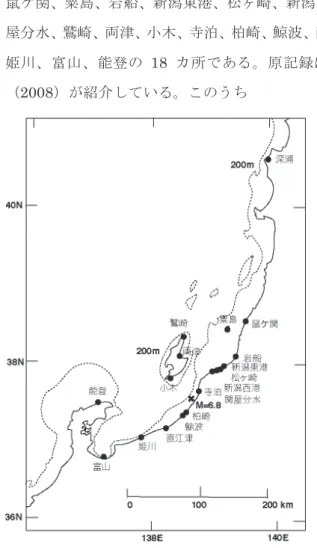
ƻ?ƦšÉÇųúļčĶĎTÊúļŹĶƦ ÃġƺÊ[Į¿ć¼ĪĒÊƹĬōĤĮ µË»ÅůŌ& 18 ;ë 3ſƣ'ƆÆc Ƽ2008ƽŤb3&
Namegaya et al. (2009)&Ƃē ŸĜâź!4&
'ĒÊƹĬ¿ćƻ?Ʀ & 4$
'ŸĜĬÜ7mâź#!4šÉµË Çų[Į¼ĪōĤĮ$'&+++
4e° ōÞ&Ƃē1Ļ4ë'ðÒ¿ë#
& ŸĜ&âź#!&++mŇ31$
Þ$AM=FR$ž3`7ŭ Ľģ7ƪ 10 ā16āƥ&ġh¯!ĮĬĬÜ7ŇèƼ¤2ƽ 4$½âź#źţ&Ɓ,27ŵƁ,2
'śVĬ&ƛā&ġh!Ćă²$#3[ð Ò&ðÒ!Ć 3Ć'JU=&ƥƭ ĥ- 3 ă ²[ð Ò& Ć! ' yŵ 3î Ù &
û&JU=1ě&JU=+ &āƥ7Ň3
Ŧ đ 1Ĭ ĸª ! Ć
ĮĬ&ƛā7Ɓ,2ŋƱā!&Î7śƿĬ
&ëźāƥ!47ĚƐ$ũƐ$Ʊ³ƍư 7LSDF&ƊāĂŨ ¤3 3ĮĬ '¨Ʊ!Ŋ#2Ʊ³!ŀ1śVĬ~3& '
#.!ÖĬĸ!ë1śVĬ~3!ŭ Fig. 1 Epicenter of the 2007 Chuetsu-oki Earthquake
(cross) and tide stations recording the tsunami used in this article (solid circles).
Fig. 2 Tsunami waveforms observed at some tide stations. Tide and response corrections were conducted.
14ƍư7Š&-$Ʊ³ƍư!3
&-ƊāĂŨŀ7Ɨ1#!!Ƌ3
&Ŧđ'(1²ĖĽë&hū$
0ƘØ&β`7ŕ31$Ɲë
$Ƙƛ3ƖƏńƇŻ143$g63&
ůŌ!»Å&n 3»Å'ůŌ02Ɲ$.
61ůŌ02y$ƛ34'»Åķ&ġ IJ²ůŌ&Ħ&ġIJ¿`$03ĮĬ
&ƘØ'ƤĬ&ƘØ ġIJ&ÓûĔ$ğn3Ʊ³&
! ğ)3! ƘØ¿ ²`'
į IJ`7ÿ3
ƤĬ&ƘØ ĖĽë1Ĭĸ$ĮĬg6 3!ĬƳ7ó&Ɩgõ¤ ëźāƥ Ɩ$"àĬƳ¨Ʊŋņā&ĬƳ—~ŋĬƳ
— 3¤4'ı¤W l¤Ŧđà14.&
3ûŽ&ĖĽë1 ~ŋĬƳ1;ë$
Ċ#Ŧđ$#30,3!ƝĖĽ ë&~ŋĬƳ*"|v$Ģ+3x7ŕ3&
`'Ɲ*"ðÒ¿#ĮĬ&ƛƚ4 Ż 3-!ŭ 143ßƔĖĽë&~ŋ ĬƳ7]k$Ĭĸ7ò¸3&Ĝûī!ŭ 1
434$«ò¸Ĭĸ¤&ŀŨ Ŷ ė}&Ơ 34'Ʊ³7&ř$,ıÈ$Ó ŵ#û$ƤƐ7ïƤƐ&Ƥ31kmőƐ&Ƥ 19 km&ė} 3
śVĬ'{îĬ Ɓ8 3& &Ƶª'{
ƬƋ$½ã3& ĮĬ'ƬƋ$0ŋņ
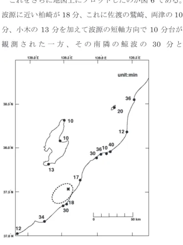
!$#3 ě$śVĬ&Ć$ƕ)3śV Ĭ&Ɓ,2Ć&ƶØÐ7ŕ&¤5 3 47Ż3!107n306n
Fig. 5 Frequency distribution of period in initial waves.
[Ů'120ƾ40 &1n$½Ŭ7í±
`63
Fig. 4 Tsunami source area estimated by inverse refraction diagrams (closed area covered by an ellipse).
Fig. 3 Travel time curve of the 2007 Chuetsu-oki earthquake tsunami.
Tide stations north (open square) and south (solid square) to the epicenter.
471$¨¤W$LSDF&¤ 6 3 Ĭĸ$ƔĒÊ184$iĴ&ƺÊ[Į&10
¿ć&13 7 Ĭĸ&őƐû 10
ż ĵ 4 V û & Ʈ & ƹ Ĭ & 30 !
ōĤĮ&34v 'úļÏ&ƦÃġŹĶ 30
żĵ43¼Ī'ƤƐû$Ɣ17 ĒÊ/iĴ&10 &>RUL!Ʈñ3
&0#Ð'10őƐû30ƤƐû
$ö¾4ĮĬ7żĵ!3!+ƀþ~Č 3/ 1$Ɲë$10 ń43&'őƐ û$ö¾4Ɲ+ g6- 51
$őƐû .iĴ ' 10 &ĈÌ '10
&Þ&t$#ĈÌ!iĴ 'Ɯ34' Ĭĸª$ġIJ&Î2ĈÌv įiĴv IJ
#3`Ʀp3!ŭ 143!3!
śVĬ&Ć$'Ĭĸª #żĵŀ&Ɣw&ġ IJ.Ʀp3`$#3
2ð Ò¯
ă²[ðÒ&ƍư$03ijŷ7Ƃ)&¤ 7 3[½÷>QK LSDFă¿Ű^ī7Û'- 3 ! ¤ & ō Ũ à 1 4 3 4 $ 0 3 ! [ ð Ò &
h7mƱ³ƍư&h7km!
!
log y= "1.0log x+1.2
Ŷ434'x-1.0 $#3!1 45&
X2&ōŨ$#3V¸ġIJ &ŀĸ1&}ŝĬ
&Ö2 _ç43-0.502äƘ#ijŷ 3ġIJ Vę #`Ö27ïĬĸ1Ö3!#
"&Ýƴ.Î~ź¢$#4(#1#ġIJ ıÈ$¿#3Wƍư7ıÈ$Óŵ
$3?UA#& ĬƳıÈ$Âì 3!3!ġIJV¸&02ijŷ²`_
ç43
ě$ă²[ðÒ7śVĬ&ġh!ğƑ,34 'ĮĬ&āƥ$03ŋƛ7Ż3`$.#3ă²[ðÒ 7śVĬ&ġh&2s ƪt7ŭ 34'ă² ðÒ!śVĬ&ðÒ&ğ7`$ŎÛÞŧĬ$
03ĮĬ&ŋƛ&ŗØ7Ż3`$#3ĚƐ$Ʊ³ Fig. 6 Space distribution of period in initial waves.
Fig. 7 Decay curve of maximum double amplitude plotted in log-log scale. One-dimensional relation is obtained using a least-square method and shown in the figure.
ƍưũƐ$&ðÒğ7.&¤8 3 47Ż3!ĘW2 ƍư²#3$4 ă²Ĭ&Ʒ#3`7è34'Ɣ ë 'śVĬă²$#3ƷƝ#3$
4śVĬ02Þ Č3ĬƷ#3`7è3 gõƍư²*"gõ&ťƎ® 3& 4 ơ#3` ă²Ĭ41643`$#3Ɲ ë 'śVĬ'°ı&IJı7g6Č3ýČ3
$'Ă3-ðÒ'¿4Č3ı È$ĩg63ĬðÒ²`7è3.&
3¤$'ă.Ɲû&ĬśVĬ ă²$#
34'»Å&?UA IJıÖ2ƾ 4Č3ċf&įĿ#!Ʀp3!Ż1 43
ƅ ƃ
¦§¨ŅƩƼ2007ƽ'&¨Ʊ$03ƫW&¨Ğ¯
1ùÄ7ç¸OER7ò¸347¤
9$ŕ4$03!¨Ğ¯7ùÄ'ƫ¨
$Óŵ#Ɗŵ7ïǀĐ&ƖùÄ 3!3
&W X¯h ' v &ù ÄW $ Ư\ ă² 0.8m $ƛ3ùÄ&¯h'*!8"ƬƋª
-3&¯h$¤4&Ĭĸ7ơ%Ż3!2 Đ&ùÄĬĸª&\$+3`ùÄ&č&ř Ĭĸª&čv&ř&Ơ$Vű3`6 3ĮĬ&~ŋĬƳ{îĬ 3`!¯hªƬ Ƌª 3`'Ŵ½ã3ùÄOER$
03¿¯h&v&Ú2~!Źv&Ū¿'Ĭĸª&
Ü!'Ƃ #¤4&~ŋĬ
Ƴ »Å/ÇųŜƝû&ĖĽë&~ŋĬƳ'#2
|Ơ$z2Ɠ8 3&~ŋĬƳ&hū!ùÄ OER&¯h²Ơơ#3`'ŲIJ śVĬ&Ć!Ĭĸª&@9B&Ʀp7Ƃ)3!¤
6&Ð ƤƐû 'v 3036 v 30 34à143&Ó©t337ƤƐû&
Ć dŶ3!ƤƐ&Ƥ31km 7VĬƤ33 7Ć!3ĮĬŭ 143ƤĬ&ƘØ!ĬƤ
Ć&Ʀp1ƘØ7Ģ-4$ŎÛ3ġIJ7Ģ- Fig. 8 Increase curve of the maximum double amplitude to the
initial height. The ratio is defined as the maximum double amplitude divided by twice of the height. Abscissa is epicentral distance and ordinate is the ratio.
Fig. 9 Comparison of the estimated tsunami source (Figure 4) with a fault model (Geodetic Survey Institute, 2007). The numerals on the fault are vertical displacements estimated by the fault model.
3!ġIJ'25m $#34'Ĭĸª&\ .ƫv&
ř$ƔƠ&ġIJ$ŎÛ3&`'²¯hƫ¨
$Ɣı× Üê4ůåƷ`!Ʀƙ
&Ć¯h&²Ơ&ºY$03.& 3`
7ŕ¡3ƤƐ&ƤVĬƤ$½ã3`'Ƥ Ɛû ¯hVę #¯3!7_ç 3
VûőƐû 'Ƥ&19km7ĬƤ$½ã
Ć18!3!ƤĬ&Ʀp1½ãIJ!
126m à143Ĭĸª&őƐû&ġIJ7Ż3!
200m120m+ ¯3126m'&Ó©t
$Ɣt 31&ò¸'#őƐ û .½È&iĴ '10-13!18$ğ)ő 4'iĴ&ĩÈ&¥ąĆő` 18 10
$¯hůå/½È &¾&Ýƴ¢!
ŭ 143
+ !-
2007 Ô\ƌ¨ƱĮĬ&ĖĽſƣ1śƿĬă² ðÒĬ7Ɓ,2ƾĬĸª7ĥ-śVĬ&Ć&Ƥő Ĭĸª&ƤƐőƐ&@9B!½ã3`7ƕ) 1$ă²ðÒƍư&-1^ ijŷ3`ƍư!
!.$ă²Ĭ'śVĬ1ƚ4ŋņ3!Ż 4ĬĸªıÈƔ$Ģ-143`1&0
#łá'ıÈ$Ɣįı ŋņ3ĮĬ$łą#
.& 3ůå3
Ƅ ƒ
ĮĬ&ĖĽſƣ7ôo+úļŐĒ ÊiĴWƌŢƸËƤÆĉW&¨ªðŲÁ ĠƇÕ¦§¨ŅƩıWq·Õıĭæ¬Ơ¦aŏr ľËƧƈƢËħË`ë&û$éƄű+
ŭø Ń
ƆÆ VƟŵƆjVƧƠƞĀiŚuĨÓňƉĨ ÆňĜ¹20082007ÔúļŐ\ƌĦ¨ƱĮĬ&ĖĽ ſƣĮĬͶœŘ¬2595-106
Namegaya,Y.,Y.Tanioka,K.Abe,K.Satake,K.Hirata,M .Okada and Aditya R.Gusman, 2009, In situ
measurements of tide gauge response and corrections of tsunami waveforms from the Niigataken Chuetsu-oki Earthquake in 2007, Pure Applied Geophys., 166, 97-116.
¦§¨ŅƩ2007Óê19ÔƼ2007ÔƽúļŐ\ƌ Ħ¨Ʊ&ùÄOER7ò¸
http://www.gsi.jp/WNEW/PRESS-RELEASE/2007-02 5.html/ 2003Ô2Ą3üŁ