_______________________________________________________________________________________________________________________________ Grace Puyang Emang, Yoshiya Touge , So Kazama
Estimating Forest Fire Severity in the Kamaishi 2017 Forest Fire using Sentinel 2A NDVI
Tohoku University Graduate School of Engineering ○ Grace Puyang Emang Yoshiya Touge So Kazama
1. Introduction
In recent years, forest fire has been regarded as one of serious natural hazards and climate change in precipitation, temperature, heatwave and enhanced evapotranspiration could lead to an increase risk of dryness hazard and occurrence of forest fire1). Temporal trends toward larger patches of high severity fire are found to be related to drought2) and higher sediment production rates were found in high fire severity forest than moderate and low severity forest fire. Previous studies were able to detect burned area but low fire severity detection and estimating fire severity were less successful. To improve detection of low fire severity, increasing field observation points to aid detection of fire severity using satellite is required. However, increasing field observation points has disadvantages such as higher time and cost is needed, a method that can easily estimate fire severity is desired. Therefore, in this study, estimation of fire severity is proposed by using Sentinel 2A NDVI and aims to verify the proposed estimation using observation of scorch crown height.
2. Study area and target event
Kamaishi is prone to forest fire and burnt areas were wide as shown in Fig.1 within this 50 years. Kamaishi Heita, the study area for this research was burned for 14 days from May 8th 2017 with an estimated burnt area of 413 ha which was greater than total burnt area in whole Japan in 2016. Prior to the forest fire, Kamaishi experienced low total precipitation in winter compared to other year in January to April 2017 and the highest wind speed was on the day of the fire. The study area is forested with mostly needleleaf trees and broadleaf trees were found on steep slopes3).
3. Methodology
3.1. Post fire observation: scorch crown height hs and relative scorch crown height, hsr
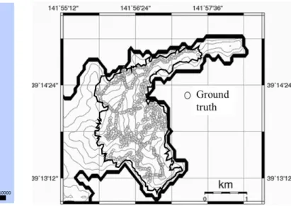
For ground truth of fire severity, scorch crown height, hs and relative scorch crown height, hsr were utilized. They were observed every 30 m which were thought to be representative of the fire severity in the area. 996 of hs and hsr respectively with various fire severities4) were obtained as shown in Fig. 2.
Fig. 1 Historical large scale forest fire occurring in Kamaishi Fig.2 Distribution of 996 ground truth utilized in the burned area indicate in black line based on information from
3.2. Remote sensing data
We used Level 1C Sentinel 2A images acquired on 25 April 2017 and 28 May 2017 which were cloud free over our study area. Both images were then processed to Level 2A for atmospheric and topography correction and NDVI was calculated using SNAP software provided by European Space Agency (ESA). The spatial resolution for NDVI is 10 m. The difference between NDVI post and pre fire image, dNDVI were extracted based on field observation points and was evaluated using hs and hsr.
4. Results
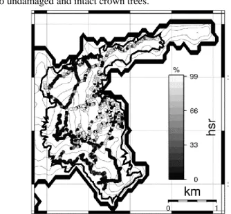
From dots distribution map of 996 points of dNDVI, hs and
hsr as shown in Fig. 3, 4 and 5, it showed dNDVI and hsr can
show more variation of fire severity than hs. This was also supported with higher R2 of dNDVI and hsr (R2 = 0.23) than dNDVI and hs (R2 = 0.08). However, detection of low fire severity using NDVI was still difficult because damages were
only visible at ground level and undetectable by Sentinel 2A due to undamaged and intact crown trees.
Fig. 5 Distribution of relative scorch crown height, hsr 5. Conclusions
All three observation indicates variation of fire severity with
dNDVI and hsr exhibiting the most variations except for low
fire severity. By using hsr, it could offer a better estimation of fire severity. These results open new prospects for estimating the fire severity in the 2017 Kamaishi forest fire more definite. Acknowledgement
We want to thank Nomura Foundation for Membrane Structure’s Technology for their financial assistance.
References
1) R. K. Pachauri et al., “Climate Change 2014: Synthesis Report. Contribution of Working Groups I, II and III to the Fifth Assessment Report of the Intergovernmental Panel on Climate Change,” IPCC, p. 151, 2014.
2) M. J. Reilly et al., “Contemporary patterns of fire extent & severity in forests of the Pacific Northwest, USA (1985-2010),” Ecosphere, vol. 8, no. 3, p. e01695, Mar. 2017. 3) Y. Touge, G. P. Emang, S. Kazama, Y. Takahashi, & K. Sasaki, Introduction of the Tohoku Forest Fires on May 2017; case in Kamaishi city of Iwate Prefecture and Kurihara city of Miyagi,” J. JSNDS, vol. 36, no. 4, pp. 361–370, 2018. 4) Y. Touge, G. P. Emang, S. Kazama, Broad Investigation of Stem Bark Char Height at Kamaishi Forest Fire in 2017; Abstract of General Society of Hydrology and Water Resources, 2018.
キーワード: Forest fire, Fire severity, NDVI, Sentinel 2A, Scorch crown
Fig. 3 Distribution of NDVI difference, dNDVI