A Geographical Study on the Foundation
of the Coastal Resort Area in the Post-Growth Society of the Southern Boso Area
Kei OTA Ph.D.
2015
TOKYO M[ETROPOLITAN UNIVERSITY
DISSER■妊「ION FOR A DEGREE OF DOCTOR OF TOURIS]M SCIENCE
TITLE:
A Geographical Study on the Foundation ofthe Coastal Resort Area in the Post口Growth Society ofthe Southern Boso Area
AUTHOR
Kei O盟2
amlner
QUALIFIED BY
THE GRADUATE SCH00L OF URBAN ENVIRONMIENTAL SCIENCES Dean
EXA]MINER BY
Examiner in chief
Date
首都 大学東京大学院
都 市環境科学研 究科
教授会 研 究科長
首都 大学東京
博 士 (観光科学
)
学位論文 (課程博 士)論 文名
ポス ト成長社会の南房総地域 における 海岸観光地の存立基盤 に関す る地理学的研究
著者 太 田
慧
審 査 担 当
4山
主査俊
副査づ
.と
、.I\
/ 副査
上記 の論 文 を合格 と判 定す る 平成
年
月
日
首都 大学東京大学院
都 市環境科学研 究科
教授会 研 究科長
i
Abstract
This thesis clarifies the foundation of coastal resort areas in the southern Boso area of the Tokyo metropolitan area in the context of the post-growth society. In modern times, tourism to remote regions has been facilitated by the advancement of air transportation, leading to a declining trend in metropolitan coastal resort areas in developed countries. In the metropolitan coastal areas of Japan in the post-growth society, there have been internal problems such as decreases in population and the decline of traditional industries such as agriculture. In response to these challenges, the southern Boso area has been transformed into a tourist region that utilizes the natural environment through the transition to agricultural cultivation that can take advantage of the mild climate, such as the cultivation of flowers and fruit.
Moreover, regarding guest house management, the guest houses have succeeded in responding to the external threats of the increase of day-trip visitors associated with the development of expressway networks by undertaking facility renovations aimed at attracting music camp visitors and sports camp guests, making it possible to host groups of students at inexpensive prices and in close proximity to the Tokyo metropolitan area. As outlined above, from a micro-level perspective, the tourist regions have been maintained through taking advantage of the social environment and locality of the post-growth society.
ii
The present study analyzed the Tokyo metropolitan coastal areas in the southern Boso area as tourist resort areas from macro- and micro scale perspectives and elucidated the foundation for the existence of these areas. In order to realize further development in the field of tourism geography, further studies are necessary not only regarding coastal resort areas in developed countries such as Japan, Europe, and the United States but also concerning resort areas in developing countries, which will enter into a post-growth society in the future.
iii
Contents
Abstract………i
Contents………iii
List of Tables………...………....viii
List of Figures………...………...ix
I. Introduction………...………...1
1. Research Concerning Regional Changes from the Viewpoint of Geography………...1
2. Tourism in Coastal Areas and Issues Related to the Post-Growth Society ………..3
1) Examples from Urban Waterfront Areas…………..…..3
2) Cases of Tourism in Periphery……….……..…4
3) Issues Related to Coastal Resort Areas and the Post-Growth Society in Metropolitan Coastal Areas……..………..…..4
3. Research Framework……….……….…7
II. Regional Issues in the Post-Growth Society of the Boso Peninsula………..……..……….….10
1. History of the Boso Peninsula from the Pre-World War II Era to the High Economic Growth Society……..…10
2. Boso Peninsula in the Post-Growth Society ……….13
iv
1) Population Dynamics in the Boso Peninsula …….….13 2) Development of Infrastructure and Changes
in Tourism in the Southern Boso Area……..……….…15 3. Regional Issues of the Southern Boso Area………….….….17
III. Changes in Agricultural Land Use and Tourism in the
Southern Boso Area as Seen from a Macro Scale Perspective..19 1. Changes in Agriculture
in the Southern Boso Area………..…………20 1) Changes in Agricultural Incomes
in the Southern Boso Area………20 2) Changes in the Number of Farmers
in the Southern Boso Area……….21 2. Changes in the Proportion of Farmland to
Cultivated Land in the Southern Boso Area……….…….…22 1) Characteristics of Agricultural Settlements and the
Natural Environment in the Southern Boso Area…..22 2) Temporal and Spatial Patterns of Changes
in the Distribution of the Proportion
of Paddy Fields to Cultivated Land……….23 3) Temporal and Spatial Patterns of Changes
in the Distribution of the Proportion
of Upland Fields to Cultivated Land……….….25 4) Temporal and Spatial Patterns of Change
in the Distribution of the Proportion
v
of Orchards to Cultivated Land………26 3. Agricultural Land Use in the Southern Boso Area
from the Viewpoint of Agricultural Management……...….27 4. Changes in Agricultural Land Use and Tourism
in the Southern Boso Area………..30 1) Flows of Changes in Agricultural Land Use
in the Southern Boso Area……….30 2) Agricultural Land Use and Tourism
in the Southern Boso Area……...………..32
IV. Establishment of Tourist Areas in the Southern Boso Area from a Micro Scale Viewpoint…………..……..……….……34
1. Overview of the Iwai Area in Minamiboso City……….…..34 2. Establishment of Guest House Regions
in the Southern Boso Area Before World War II…………..36 3. Establishment of Guest House Regions
in the Iwai Area Following World War II………...…37 4. Development of Guest House Regions
in the Iwai Area During the Period
of High Economic Growth………38 1) Changes in Agriculture in the Iwai Area ……….…....38 2) Changes in Land Use in the Iwai Area……….….39 5. Establishment of Guest House Regions in the Iwai Area
During the Period of High Economic Growth………..……..40
vi
V. Foundation for the Existence of Guest House Regions
in a Post-Growth Society………..…………...42 1. Changes in the Socioeconomic Environment
in the Iwai Area During the Post-Growth Society………...42 2. Changes in Land Use and Guest House Facilities
in the Iwai Area………..44 1) Changes in Land Use in the Iwai Area………..44 2) Changes in Guest House Facilities
in the Iwai Area……….45 3. Guest house Management in Guest House Regions
in the Iwai Area………..47 1) Characteristics of the Distribution of Guest House
Facilities in the Iwai Area by Size………..47 2) Guesthouse Management
and Employment Structure in the Iwai Area……..….49 4. Foundation for the Existence of Guest House Regions
in a Post-Growth Society……….………53 1) Iwai Area………..………..54 2) Tateyama Guest Houses ……….……...54 3) Foundation for the Existence of Guest House Regions
in the Southern Boso area
in the Post-Growth Society………....56
VI. Metropolitan Coastal Areas and Tourism
in a Post-Growth Society………..59
vii
1. Regional Changes in the Southern Boso Area
from a Macro Scale Viewpoint………..……….60 2. Regional Changes in the Southern Boso Area
from a Micro Scale Viewpoint…………..………..61 3. Conclusion………...62
References………64
Tables and Figures Acknowledgements
viii
List of Tables
Table. III-1 Changes of number of farmers in the Southern Boso area.
Table. III-2 The number of agricultural product sales combination.
Table. III-3 Combination of typical farming form in the Southern Boso area.
Table. IV-1 The changes of part-time farmers in Iwai.
Table. V-1 The changes of guest house facilities.
Table. V-2 Guest house facilities in 2014.
ix
List of Figures
Fig. I-1 Metropolitan structure and periphery.
Fig. I-2 Schematic model of land-use changes and driving forces in the urban waterfront area.
Fig. I-3 Research methods and flowchart.
Fig. II-1 Study area.
Fig. II-2 Patterns of population redistribution on the Boso Peninsula from 1980 to 1995.
Fig. II-3 Patterns of population redistribution on the Boso Peninsula from 1995 to 2010.
Fig. II-4 Traffic networks of the Boso Peninsula.
Fig. II-5 Changes in means of transportation in the Awa area.
Fig. II-6 Changes in the number of tourists staying in lodging facilities in the Awa area.
Fig. III-1 Changes in agricultural incomes on the Boso Peninsula.
Fig. III-2 Climate and terrain on the Boso Peninsula.
Fig. III-3 Paddy fields in 1970.
Fig. III-4 Paddy fields in 2010.
Fig. III-5 Upland fields in 1970.
Fig. III-6 Upland fields in 2010.
Fig. III-7 Orchards in 1970.
x
Fig. III-8 Orchards in 2010.
Fig. III-9 Distribution patterns in agricultural regions on the Boso Peninsula in 1970.
Fig. III-10 Distribution patterns in agricultural regions on the Boso Peninsula in 1990.
Fig. III-11 Distribution patterns in agricultural regions on the Boso Peninsula in 2010.
Fig. III-12 Trends in agricultural land use changes (1970–1990).
Fig. III-13 Distribution patterns in agricultural land-use changes (1970–1990).
Fig. III-14 Trends in agricultural land use changes (1990–2010).
Fig. III-15 Distribution patterns in agricultural land-use changes (1990–2010).
Fig. III-16 Changes in the number of tourists on the Boso Peninsula.
Fig. IV-1 Iwai area.
Fig. IV-2 Iwai land use in 1966.
Fig. IV-3 Iwai land use in 1974.
Fig. V-1 Number of guest houses.
Fig. V-2 Population changes in Tomiyama Town.
Fig. V-3 Changes in the number of tourists in the Iwai area.
Fig. V-4 Iwai land use in 1987.
Fig. V-5 Iwai land use in 2014.
xi
Fig. V-6 Guest house capacity in Iwai (2014).
Fig. V-7 Employment structure of a large-scale guest house.
Fig. V-8 Employment structure of a medium-scale guest house.
Fig. V-9 Employment structure of a small-scale guest house.
Fig. V-10 Foundation model of the guest house regions.
Fig. V-11 Model of the guest house region in the high-growth period and post-growth society.
Fig. VI -1 Regional changes in the southern Boso area.
1
I. Introduction
1. Research Concerning Regional Changes from the Viewpoint of Geography
In the field of geographical studies, research on regional changes such as in regard to land use and transitional processes related to such use in urban areas and metropolitan areas affected by human activity has been broadly conducted. Such studies concerning regional changes in metropolitan areas were actively conducted during Japan’s period of high economic growth, during which significant national land development was carried out (Tsutsumi, 2009). There have also been studies that have analyzed regional changes from different perspectives on land use. When examining land use, it is necessary to accurately understand and elucidate appropriate land use from the micro- and macro scale viewpoints in accordance with the research topic (Kiuchi, 1979).
During periods of high economic growth, metropolitan coastal areas have been the areas in human history with the highest level of human activity and the areas with the highest population densities. The coastal areas of Japan, which have achieved particularly rapid high economic growth, are regions that have experienced significant regional changes: due to the proximity of these regions to the water and their high potential for development related to industry, housing, and tourism, changes in land use that
2
have occurred in such areas exhibit a high level of dynamism.
Research on coastal areas during periods of high economic growth has focused on the analysis of regional structures in the context of the industrialization of agricultural land (Shigemi, 1968; Shigemei, 2000). Changes in land use and related factors have often been analyzed in the field of geography in connection with the analysis of the above-mentioned regional changes.
Meanwhile, the development of coastal resort areas as part of regional changes occurring during periods of economic growth has also been examined from various viewpoints and not only those of urbanization and industrialization. Due to increases in the demand for leisure associated with higher incomes among urban residents that accompanied the period of high economic growth, tourism began to be developed in coastal areas and mountainous regions located in the far suburbs of metropolitan areas (Ishii, 1970). The establishment of guest houses during periods of high economic growth has been explained by looking at the changes in land use and employment structure (Birukawa et al., 1974; Ishii, 1977;
Konishi, 1980; Tanno, 1985; Ishii and Shirasaka, 1988; Kureha, 1991; Tanno, 1998). These previous studies generally revealed that guest houses came to be established because of the availability of surplus labor during the agricultural and fishing off-seasons. As described above, previous studies concerning tourism during the period of high economic growth have focused on the analysis of external factors such as regional changes and the increased
3
demand for leisure and internal factors such as changes in employment structure.
2. Tourism in Coastal Areas and Issues Related to the Post-Growth Society
Since ancient times, coastal areas have been used not only as bathing areas but also as spaces for leisure and recreation due to their scenic landscapes. Changes in coastal areas and tourism can be broadly divided into three spatial structures: urban waterfront areas, metropolitan coastal areas, and peripheries (Fig. I-1).
1) Examples from Urban Waterfront Areas
As an example of regional change in coastal areas, the spaces that supported what were formerly industrial and wharf areas along the coasts of urban areas were turned into new tourism spaces through redevelopment triggered by changes in port logistics systems (Wrenn, 1986; Law, 1994; Hoyle, 1996; Sakai, 2002). The creation of recreation spaces in these coastal urban areas has been observed in North America, where changes in port logistics systems have progressed the quickest, and the active redevelopment of waterfront areas has also become apparent in Japan since the 1990s (Ota, 2013; Ota, 2015). In other words, although an overall declining trend in metropolitan coastal areas
4
was seen during the 1980s, the development of urban waterfront areas led to the creation of new recreation spaces.
2) Cases of Tourism in Periphery
With the development of passenger aircraft after World War II, coastal resorts were formed in periphery, joining pre-existing coastal resort areas in metropolitan coastal areas. Pleasure periphery in these periphery hosted many tourists; tourists from Europe gathered in resorts along the Mediterranean coast, tourists from Europe and Asia along the Great Barrier Reef of Australia, and tourists from North America along the coasts of the Caribbean Sea (Young, 1983; Meyer, 2001; King, 2007). However, the degradation of the environment due to the rapid development of coastal resort areas in periphery has been indicated. Moreover, Ota and Iizuka (2015) clarified the development of tourism and spatial configuration of a fishing village located along the coast by taking Marsaxlokk in the Republic of Malta, a pleasure periphery located in the Mediterranean Sea, as an example.
3) Issues Related to Coastal Resort Areas and the Post-Growth Society in Metropolitan Coastal Areas
Coastal resort areas in metropolitan coastal areas are old forms of resort area (Shaw and Agarwal, 2007). Coastal resort areas have
5
developed along with the modernization of the industrial structure;
their origin can be found in early 19th-century England. These coastal resort areas have evolved along with the modernization of the industrial structures; coastal resort areas developed along the Mediterranean coast of France in the mid-19th century and in Belgium during the latter half of the 19th century (Urry, 1990;
Yamamura, 1995; Urry and Larsen, 2011). This trend can also be seen in Japan; beginning in the latter part of the Meiji period, swimming beaches appeared in the metropolitan suburbs such as Tokyo and Osaka. Following this, coastal resort areas were formed in the metropolitan suburbs of Shonan, Boso, and Nanki-Shirahama during the 1930s (Kanda, 2001; Kanda, 2012). Of course, developments in coastal resort areas located in the metropolitan suburbs of Western Europe and Japan were related to the development of rail networks connecting the metropolitan areas and tourist areas (Tanno, 1986; Pearce, 1987; 1995). However, a declining trend was seen in the tourist destinations with a long history in the metropolitan areas of developed countries; these areas gradually became out of date due to dramatic improvements in transportation conditions, such as that related to the widespread use of aircraft following World War II. This trend was seen in England during the 1970s (Urry, 1990) and gradually emerged in Japan during the 1980s. Tourism areas are influenced by socio-economic factors and environmental factors. Thus, in discussing tourism areas, we need geographical approaches that consider such factors. Since Butler
6
(1980), many researchers have discussed the lifecycle of tourism areas.
Gormsen (1981; 1997) attempted to incorporate not only ideas about spatial and temporal evolution but also ideas about the development process and social structure. Gormsen’s models are mainly based on European perspectives. In the European context, Gale (2007; 2009) analyzed the external threats and internal problems of Northern European coastal resorts and cited reasons such as the increase in day tourists, tourist seasonality, and old-fashioned accommodation as causes for the decline of coastal resorts.
These types of regional change in the post-growth society have also been discussed from the viewpoints of urban geography and population geography. For example, Koizumi (2015) described the population demographics of the Tokyo metropolitan area based on distance in a macro scale analysis. Moreover, with regard to population dynamics in urban areas, the characteristics in the increases in population in Tokyo Metropolis by area since the year 2000 have been elucidated (Yabe, 2003; Miyazawa and Abe, 2005).
Studies have reported significant population increases in the coastal areas of Minato Ward in Tokyo Metropolis; one factor in this has been the construction of apartment complexes due to the drop in land prices since the collapse of the Japanese bubble economy.
Moreover, in the field of tourism geography, Nakajo (2009) investigated the employment structure of guest house communities on the coast of the Izu Peninsula, which have principally hosted tourists from the Tokyo metropolitan area, and elucidated how such
7
guest houses have been maintained in the face of decreases in population and the aging of society. Changes that have taken place in Japan since the 1990s reflect a post-growth society and are an important target of research in the field of geography. These regional changes in Japanese metropolitan areas since the 1990s comprise a new phenomenon to which European and American models are not applicable (Hino, M. and Tsutsumi, J., 2015; Hino, M. and Kagawa, T., 2015).
As described above, urban waterfront areas, metropolitan coastal areas, and periphery coastal regions have experienced different types of development, but research on these coastal areas has been limited to the analysis of specific characteristics of each area; a systematic overview comparing areas has been lacking. Thus, the present study aims to elucidate the changes and the basis for the existence of metropolitan coastal areas in a post-growth society.
Based on this, I elucidate the related issues and how coastal resort areas have been maintained in metropolitan areas in contemporary Japan.
3. Research Framework
Based on past geographical research on coastal areas, the present study aims to elucidate the foundation of coastal resort areas in coastal areas on the periphery of the Tokyo metropolitan area. In order to elucidate the research topic, the present study
8
aims to first reveal the social issues related to coastal areas in a post-growth society through a macro scale analysis of changes in population dynamics and agricultural land use. In addition, by performing a fieldwork-based micro scale analysis of coastal resort areas in rural coastal communities, I analyze changes in coastal regions from a multilayered viewpoint.
Furthermore, the present study also examines issues related to the analysis of regional changes in geography. Previous studies in the field of geography have analyzed regional changes as the basis for the existence of such areas. The basis for the existence of such regions has been analyzed from three viewpoints: 1) land use, 2) socio-economic environment, and 3) employment structure (Ishii, 1992). However, when examining regional changes, the need to accurately identify such changes has been a problem in the field of geographical studies (Kiuchi, 1979; Tsutsumi, 2009). Thus, in the present study, I aimed to perform a macro scale analysis and micro scale analysis at the community level in order to observe regional changes on multiple levels.
In Chapter II, I summarize the history and current status of tourism in the coastal areas of the Tokyo metropolitan area and elucidate the issues related to the population demographics of the Boso Peninsula, the principal target of research in the present study. In Chapter III, I perform a macro scale analysis of changes in land use with a focus on agriculture, the principal industry of the southern Boso area, while examining the natural conditions
9
that led to changes in agricultural land use during the period of high economic growth and the post-growth society. In Chapters IV and V, I elucidate the basis for the existence of guest house regions and related issues through a micro scale analysis at the community level. In Chapter VI, I perform a multitiered micro scale analysis of the southern Boso area and a micro scale analysis at the community level while elucidating the existence of coastal resort areas in Tokyo metropolitan coastal areas.
10
II. Regional Issues in the Post-Growth Society of the Boso Peninsula
The entirety of the area of the Boso Peninsula belongs to Chiba Prefecture; most of Chiba Prefecture is located within the Tokyo metropolitan area (it is 75 km from the center of Tokyo; Fig. II-1).
In this chapter, I elucidate the history of the development of tourism in the Boso Peninsula by consulting previous research.
Moreover, I examine the characteristics of regional changes in the Boso Peninsula from the period of high economic growth to the post-growth social period through an observation of population dynamics from 1980 to 2010. Through this, regional and tourism-related issues of the Boso Peninsula are identified.
1. History of the Boso Peninsula from the Pre-World War II Era to the High Economic Growth Society
There have been numerous studies in the field of regional geography concerning the development of the Boso Peninsula from the modern period to the period of high economic growth. This is because as part of the Tokyo metropolitan area, the Boso Peninsula experienced various regional changes along with the development of the capital region of Tokyo in Japan’s period of economic growth.
Tourism in the Boso Peninsula began in the 1915 when a swimming beach was opened in the Hojo coastal area, which corresponds to
11
the current center of Tateyama City (Ikeda, 2001). Osaki (1938a;
1938b), a pioneer in regional research on the Boso Peninsula, revealed the relationship between natural conditions and the distribution of swimming beaches in the Boso Peninsula. According to these studies, the southern Boso area was established as a coastal resort area in the 1930s before World War II, as shown by the operation of special trains from Tokyo during the summer season and the presence of camp stores run by university students.
In addition, Osaki (1976) analyzed the locations of golf courses based on their distance from the metropolitan center and found that the majority of golf courses were located in three major metropolitan areas, including in the Boso Peninsula. According to the study, factors that led to this included increases in the number of golf courses and golf players in Japan, the development of the national economy, improvements in personal incomes, tax avoidance policies by companies during a certain period and the implementation of welfare measures, the implementation of the five-day workweek, an orientation toward leisure among citizens, improvements in traffic conditions, and an increased number of car-owners. The results of these studies were summarized by Osaki (1967 and 1985).
Kikuchi (1980) summarized the development of the Boso Peninsula during the period of high economic growth from the viewpoint of historical geography. According to this study, the Boso Peninsula was a backward region that was left behind during the
12
period of economic development, but during the period of high economic growth beginning in the 1960s, the creation of industrial areas through the reclamation of land in Tokyo Bay and the formation of suburbs in the northwest area of the Boso Peninsula, which lies adjacent to Tokyo, significantly increased, causing the region to experience rapid progress. In addition, Yamamura (1995) evaluated the position of the Boso Peninsula in regard to the Tokyo metropolitan area from the standpoint of touristic geography and examined the characteristics and challenges facing the southern region of the Boso Peninsula in comparison with those facing the Izu Peninsula. According to the study, the Southern Boso area has fewer hot springs in comparison with the Izu Peninsula; the area was classified as a resort area that had been established by small-scale tourism operators—primarily guest houses.
Thus, the following two characteristics of the development of the Boso Peninsula can be explained from the above three previous studies. First, in comparison with other regions, the development of infrastructure in the Boso Peninsula was delayed due to the fact that the area was not located along the main routes of Japan, such as the Tokaido or Tohokudo routes. This greatly differs from the experience of the coastal area of Suruga Bay, which evolved as an industrial area prior to World War II: the region has a warm climate similar to that of the Boso Peninsula, but is located on the Tokaido route, a major transportation route of Japan (Ota and Kikuchi, 2015a; 2015b). The second characteristic is that there is
13
an extremely large difference between the northern area of the Boso Peninsula, which lies adjacent to Tokyo, and the southern area. The northern part of the Boso Peninsula is an area that underwent particularly rapid development after the period of high economic growth in Japan. By contrast, the southern area of the Boso Peninsula was a region in which the primary sector of the economy, which was based on agriculture, continued to predominate after World War II. The above two characteristics characterize the Boso Peninsula during the period of high economic growth.
2. Boso Peninsula in the Post-Growth Society
1) Population Dynamics in the Boso Peninsula
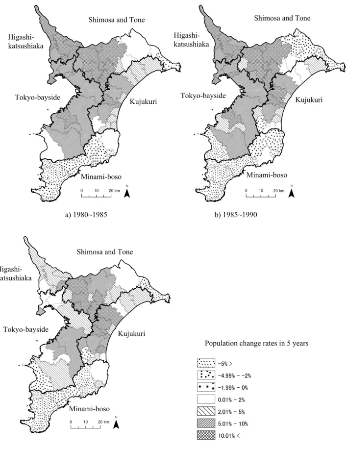
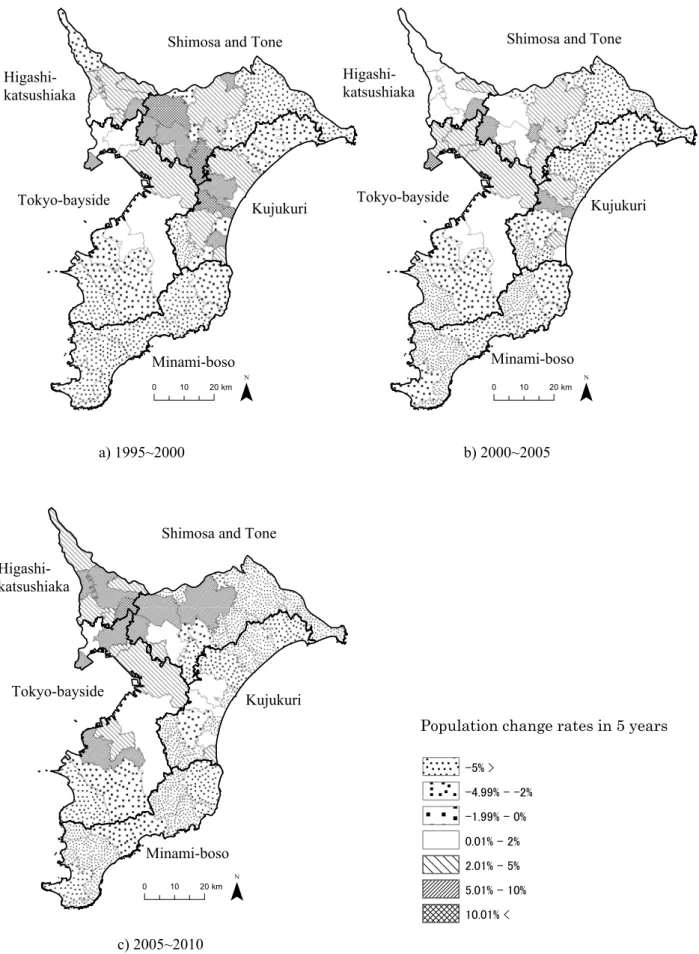
In order to understand the population dynamics of the Boso Peninsula, I used the total population data of each municipality obtained by the National Census for the years 1980, 1985, 1990, 1995, 2000, 2005, and 2010 and compared these data with those obtained in previous years in order to view the rate of change in population as shown in Figs. II-2 and II-3. In Figs. II-2 and II-3, I adopted a regional classification system that divides the Boso Peninsula into five areas based on industrial clusters (Tokyo Bay area, Higashi-Katsushika, Shimousa-Tone, Kujukuri, and Southern Boso area; according to Yamamura, 2009). Moreover, in
14
consideration of mergers of municipalities, the figures are based on the boundary data for 2010. According to these data, during the period from 1980 to 1985, increases were observed in all areas of the Boso Peninsula, especially in the Tokyo Bay area, Higashi-Katsushika, and Shimousa-Tone, which lie adjacent to Tokyo Metropolis and where population increases of 5% or higher were observed. By contrast, a decreasing trend was seen in the population of the southern Boso area; the rate of decrease was approximately 5%. During the period from 1985 to 1990, a population growth rate higher than 10% was observed in Kujukuri, whereas the declining trend in population expanded in the southern Boso area and the Shimousa-Tone area. By the 1990s, the past trend of increasing population growth spread to other regions, though it was less than 5%, and the decline in population continued in the southern Boso area.
Fig. II-3 shows the population dynamics in the Boso Peninsula from 1995 to 2010. According to this, with the exception of the northwest area, there has been a decreasing trend in the population of the Boso Peninsula since 1995. This trend was observed in all regions of the Boso Peninsula until 2010, but from 2005 to 2010, the northwest area of the Boso Peninsula, which lies adjacent to Tokyo, included municipalities with population growth rates exceeding 5%. Meanwhile, multiple municipalities in the southern part of the Boso Peninsula such as the Southern Boso area and Kujukuri experienced more than 5% decreases in
15
comparison with the previous year. In other words, the latest regional trends for population dynamics in the Boso Peninsula reveal an increase in the population of the northwest area, which lies adjacent to Tokyo, and a decreasing trend in the southern area of the Boso Peninsula. Thus, dichotomous trends were observed in the two regions.
Based on this, I perform an analysis of the southern Boso area by taking the late 1980s onward as the post-growth society, when the increasing trend in the population of northwest area of the Boso Peninsula started to slow down and the decrease in the population of the Southern Boso area began to accelerate.
2) Development of Infrastructure and Changes in Tourism in the Southern Boso Area
Because the Boso Peninsula is not located on a major route in Japan such as the Tokaido route or Tohokudo route, the region experienced delayed development of railroad and expressway networks. Fig. II-4 shows the opening years of operation of expressways in the Boso Peninsula. Based on these data, it can be seen that the development of an expressway network was significantly delayed in comparison with the railroad network, which had already been established before World War II. The only expressway that was completed in the 1980s was the one that linked Tokyo with Narita Airport via Chiba City, the capital of
16
Chiba Prefecture. In contrast with the delays in the development of transportation infrastructure as outlined above, the expressway network in the Boso Peninsula has rapidly developed since the 1990s. Along with the extension of the expressway from Chiba City to Kisarazu City, the Tokyo Bay Aqua-Line, which crosses Tokyo Bay, was opened in 1997, connecting the peninsula with the opposite shore of Kawasaki City in Kanagawa Prefecture. Because of this route, access from Tokyo Metropolis and Kanagawa Prefecture to Chiba Prefecture dramatically improved. However, it was only in the 2000s that Kisarazu City, which is the final stop of the Tokyo Bay Aqua-Line on the Chiba Prefecture side, and the southern Boso area were connected by an expressway.
These developments in the expressway network of the Boso Peninsula reflect changes in the methods of transportation used by visitors who visit the area. Fig. II-5 shows changes in the means of transportation used to visit the Awa region, which is located on the southern tip of the Boso Peninsula. According to these data, there has been a decreasing trend in visitors visiting the area by train since the 1980s, whereas the number of visitors visiting by car has continued to increase. The number of visitors visiting by car was approximately 5 million in 1980 and increased to approximately 9 million by 2003. Moreover, since the opening of the Tokyo Bay Aqua-Line in 1997, the number of visitors visiting by bus increased; in 1997, approximately 2.5 million visitors visited by bus, but in 1998, the number increased to approximately 3.8
17
million.
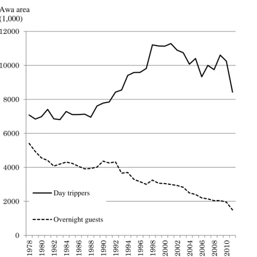
Fig. II-6 shows changes in the number of tourists staying in lodging facilities in the Awa region, which is located on the southern tip of the Boso Peninsula, and the number of day-trip tourists. According to these data, the number of tourists staying in lodging facilities has continually decreased since the 1980s, whereas the number of day-trip tourists has continued to increase.
The increase in day-trip tourists has been especially significant since the 1990s, which shows the effects of the creation of the Tokyo Bay Aqua-Line and other expressway networks. The above findings show that the Boso Peninsula in the post-growth society can be characterized by an increase in the number of day-trip tourists due to decreases in population and the development of transportation infrastructure.
3. Regional Issues of the Southern Boso Area
As described above, the population decline in the southern Boso area that has continued since the 1980s and the increase in the number of day-trip tourists accompanied by decreases in tourists staying in lodging facilities since the 1990s are issues for the region. I selected the Southern Boso area as a target region for examining how regions in Japan have tackled post-growth social issues facing the country. Through this examination, I elucidate
18
the foundation of the existence of coastal resort areas in Japanese metropolitan coastal areas.
19
III. Changes in Agricultural Land Use and Tourism in the Southern Boso Area as Seen from a Macro Scale Perspective
In this chapter, I examine changes in the use of agricultural land, which supports the key industry of agriculture in the Southern Boso area. Although the Boso Peninsula is located in the Tokyo metropolitan area, it is a region in which the primary sector of the economy was predominantly based on agriculture and fishing, in contrast with Kanagawa and Shizuoka Prefectures, which experienced significant changes in industrial structure during the period of high economic growth due to their location on the Tokaido route. However, beginning in the 1990s, significant improvements in transportation infrastructure were made—for example, bypasses and expressways such as the Tokyo Bay Aqua-Line in the southern Boso area were developed. These developments led to various regional changes. Thus, based on an analysis of changes in agricultural land use, the principal aim of the present study is to examine regional changes in agriculture, the primary industry in the southern Boso area. Analyses using data from the Census of Agriculture and Forestry have long been based on macro scale analytical methods, such as a study concerning the classification of agricultural regions in southern Ontario, Canada (Tabayashi, 1982). In recent years, there has been research utilizing data from the Census of Agriculture and Forestry and GIS, research that has utilized various indicators of agricultural management to create a
20
classification system for agricultural regions across Japan (Nihei, 2006), and research that has clarified changes in agricultural land use in Mount Fuji and surrounding areas based on the relationship with the natural environment (i.e., differences in elevation) (Ota and Kikuchi, 2015a; 2015b). These studies have analyzed results pertaining to regional distribution patterns of agricultural land use and their respective causes. Based on these previous findings, in this chapter, I primarily analyze changes in agricultural land use in the southern Boso area using data from the Census of Agriculture and Forestry.
1. Changes in Agriculture in the Southern Boso Area
1) Changes in Agricultural Incomes in the Southern Boso Area
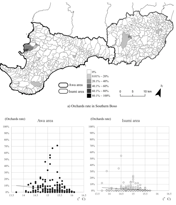
The present study defined the target region of the southern Boso area as regions corresponding to what was formerly Awa Province under the old Ritsuryo system as well as the Isumi area, which has strong industrial and transportation links with the Awa region. I also reveal agricultural trends in the southern Boso area based on changes in agricultural incomes. Data indicate that, in 1970, incomes dramatically increased in the towns and villages within present-day Minamiboso City (Fig. III-1-a). Similarly, an increasing trend was also observed in other municipalities during the 1970s, but after the late 1990s, a decreasing trend was
21
apparent. Fig. III-1-b shows agricultural incomes produced in each town and village before the Minamiboso City merger of 2005. Fig.
III-1-b shows that the increase in Maruyama Town during the 1970s was especially notable, whereas a gradual increase was observed from the 1970s to 2000 in Shirahama Town, located on the southern tip of the Boso Peninsula. Thus, a significant increase in agricultural incomes in the Southern Boso area was seen in towns and villages within present-day Minamiboso City; increases in agricultural incomes in Maruyama Town, Tomiyama Town, Wada Town, and Miyoshi Village during the 1970s were especially notable.
2) Changes in the Number of Farmers in the Southern Boso Area
Table III-1 shows changes in the number of farming households in the Southern Boso area by municipality. Because the method to calculate the total number of farming households in 1970 differed from the method to calculate farming households engaged in selling in 2010, the two figures are listed with reference to data from 1990.
According to these data, there were decreases in the number of farming households in all municipalities during the period from 1970 to 2010. During the period from 1970 to 1990, a significant increase in agricultural incomes in Maruyama Town was observed, but the total number of farming households decreased from 1,348 to 1,126. Similarly, it was shown that the number of farming
22
households decreased even in municipalities where increases in agricultural incomes were observed, such as in Tomiyama Town, Wada Town, and Miyoshi Village. Based on these findings, it appears that improvements in agricultural income did not contribute to maintaining the numbers of farming households, but the change in cultivated crops in the southern Boso area led to improvements in agricultural income.
2. Changes in the Proportion of Farmland to Cultivated Land in the Southern Boso Area
1) Characteristics of Agricultural Settlement and the Natural Environment in the Southern Boso Area
Here, I examine regional characteristics based on the distribution patterns of land use in agricultural settlements in the southern Boso area. The characteristics of agricultural settlements in the southern Boso area obtained from data of the Census of Agriculture and Forestry revealed that agricultural settlements located in the eastern and southern areas tended to be comparatively small in area. This is because the coast of the eastern region of the Boso Peninsula is mountainous and has a steep terrain, limiting the inhabitable area; therefore, small-scale agricultural settlements were formed. However, agricultural settlements with comparatively large areas are distributed in the
23
plains of the surrounding area of Tateyama City, the largest city in the southern Boso area.
Fig. III-2 shows the terrain and the annual mean temperature in the southern Boso area as shown in units of agricultural settlements. These data revealed that the areas with the lowest annual mean temperature were mountainous areas with an elevation of 200 m or higher located in the inland area of the Boso Peninsula and that there were some areas with temperatures lower than 14℃. By contrast, the mean temperature in the southern coastal area of the southern Boso area is relatively high; most areas of the southern Boso area have a mean temperature of 15℃ or higher. The coastal areas of Tateyama City and Minamiboso City had the highest annual mean temperatures (temperatures of 16℃
or higher). This is due to the influence of the warm Kuroshio current; the mean temperature was the same as Kagoshima Prefecture, which is located in the southern part of Kyushu. In summary, the annual mean temperature is lower in the central mountainous area and higher in the coastal areas of the Boso Peninsula. Along the southern coast of the Boso Peninsula, the temperature tends to be especially high.
2) Temporal and Spatial Patterns of Changes in the Distribution of the Proportion of Paddy Fields to Cultivated Land
The proportions of paddy fields to cultivated land in 1970 by
24
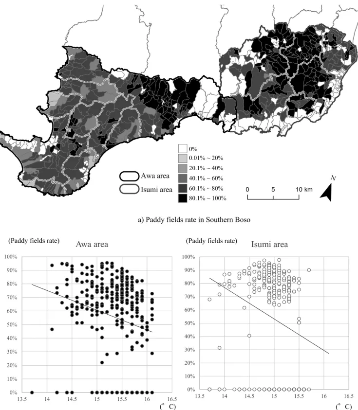
agricultural settlements are shown in Fig. III-3-a based on agricultural settlements card data from the Census of Agriculture and Forestry. According to these data, agricultural settlements with a proportion of paddy fields to cultivated land under management of 80% or higher were concentrated in the eastern part of the southern Boso area and in the flatlands of Kamogawa.
However, the proportion of paddy fields to cultivated land in the southern area of the Boso Peninsula was relatively low (generally less than 60%). By 2010, areas with proportions of paddy fields to cultivated land of 80% or higher had expanded primarily into the inland area of the southern region of the Boso Peninsula (Fig.
III-4-a). The coastal region of the southern part of the Boso Peninsula had a similarly low proportion of paddy fields to cultivated land, as in 1970. This is because the southern coast of the Boso Peninsula has a steep terrain with narrow, steep slopes;
therefore, it is unsuitable for rice cultivation. Moreover, observing the relationship between the proportion of paddy fields to cultivated land and mean temperature revealed that the decrease in the proportion of paddy fields to cultivated land was notable in agricultural settlements that had a mean temperature of 15℃ or higher. The decrease in the proportion of paddy fields to cultivated land in warmer agricultural communities as described above was a result of the shift to other crops in order to take advantage of the warm climate (Fig. III-4-b).
25
3) Temporal and Spatial Patterns of Changes in the Distribution of the Proportion of Upland Fields to Cultivated Land
Fig. III-5-a shows the distribution of the area rate of upland fields to cultivated land in the entire Southern Boso area in 1970.
In 1970, the proportion of upland fields to cultivated land was relatively high in the southern region of the Southern Boso area in comparison with the eastern area. The proportion of upland fields to cultivated land was highest in the coastal region of the Boso Peninsula. Agricultural settlements with proportions of 60% or higher were noted; these were the same communities with low proportions of paddy fields to cultivated land. An increasing trend in the proportion of upland fields to cultivated land was observed in 2010 compared with the figures from 1970 (Fig. III-6-a). By contrast, a decreasing trend in the proportion of upland fields to cultivated land was seen in the inland area of the Boso Peninsula, showing that the differences in the proportion of upland fields to cultivated land among all of the areas of the Southern Boso area have grown larger. The relationship between the proportion of upland fields to cultivated land and mean temperature in 2010 revealed that in comparison with 1970, there was a marked expansion in agricultural settlements with a mean temperature of 15℃ or higher (Fig. III-6-b). For example the establishment of the
“Boso Flower Line,” a coastal road in the warm southern coast of the Boso Peninsula, in 1966, flower cultivation along the coastal
26
road has been promoted in the area. This policy was the principal factor in the increase in the proportion of upland fields to cultivated land along the coast of the southern region of the Boso Peninsula.
4) Temporal and Spatial Patterns of Change in the Distribution of the Proportion of Orchards to Cultivated Land
Fig. III-7-a shows the distribution of the area rates of orchards to cultivated land in 1970. According to these data, orchards was generally not distributed in the southern Boso area, with the exception of parts of Tomiura Town and Otaki Town. The only agricultural settlement with a proportion of orchards to cultivated land of 60% or higher was Tomiura Town. Loquat cultivation has flourished in Tomiura Town since the Edo period and a system to ship loquats to Tokyo was developed during the Taisho period. The reason Tomiura Town had such a high proportion of orchards to cultivated land was because the town has a long history of horticulture (primarily loquats). By 2010, agricultural settlements with high proportions of land under orchards to cultivated land were observed to have exhibited expansion in Tomiura Town and Otaki Town, which had comparatively high area rates of orchards to cultivated land in 1970 (Fig. III-8-a). Especially in surrounding areas adjacent to Tomiura Town, agricultural settlements with high proportions of orchards to cultivated land were observed to
27
have exhibited expansion in neighboring Tomiyama Town. The primary reason for this increase in the number of farming households involved in loquat cultivation was the increase in the profitability of loquat cultivation due to the introduction of greenhouse technology. The proportion of orchards to cultivated land in the southern Boso area from 1970 to 2010 generally tended to be low; only in some coastal agricultural settlements in locations such as Tomiura Town were proportions of orchards to cultivated land high.
3. Agricultural Land Use in the Southern Boso Area from the Viewpoint of Agricultural Management
Using data from the "Number of Management Entities by No. 1 Sale Sector of Agricultural Products" of the Census of Agriculture and Forestry for 1970, 1990, and 2010 as indices, I calculated the types of combination pattern in agricultural management entities by agricultural settlement for the years 1970, 1990, and 2010. I used the John Weaver's method as modified by Doi (1972) in calculating data from the number of management entities by No. 1 agricultural product sale sector. The modified Weaver's method is a calculation method to express the combination of factors that is related to regional characteristics, as other elements that do not exhibit maximum values can be completely ignored when a method based on the maximum composition ratio is used to analyze
28
regional characteristics (Otomo, 1997). A modified version of the method used by Weaver was used to classify agricultural regions at the macro scale (Tabayashi, 1982) and land-use changes were analyzed using GIS (Sugimori and Ohmori, 1996; Ota and Kikuchi, 2015a; b). Table III-2 shows the number of combinations for each period. With these data, a comparison of 1990 and 2010 revealed that the number of single-type agricultural settlements increased from 253 to 285 whereas the number of agricultural settlements with four types decreased from 10 to 4. This indicates that agricultural production in the southern Boso area was streamlined during the post-growth society. Here, I examine the regional characteristics of agricultural land use in the southern Boso area from the period of high economic growth to the post-growth society based on a GIS visualization of the calculation results obtained using the modified Weaver's method.
Furthermore, the results of extracting typical combination patterns that existed in five or more agricultural settlements are shown in Table III-2. During these three periods, the most common type of combination pattern of agriculture in the southern Boso area was R (rice) only (Table III-2). Following R (rice) only, the next most common combination was RD (rice and dairy farming): the number of RD agricultural settlements decreased from 46 in 1970 to 28 in 1990. However, by 2010, L (flowers) had increased to 47 agricultural settlements, a figure second to the top pattern, R (rice) only. Moreover, as shown in Table III-3, an increasing trend was
29
observed in the number of single-type agricultural settlements during the period from 1970 to 2010; a trend toward changing from multiple to single business management was apparent.
Fig. III-9 shows the combinations and distribution pattern of agricultural land use in the southern Boso area during the 1970s.
According to these data, rice cultivation was dominant in the so-called Sotobo region, which corresponds to the Isumi-gun area and Kamogawa City, and in the plains of Tateyama City, whereas dairy farming only or a combination including dairy farming was notable in agricultural settlements located at relatively high elevations in the Awa region. Moreover, combinations with F (fruit), which mainly referred to the loquat cultivation that had continued from before the start of World War II, were seen only in parts of Tomiura Town and Tomiyama Town. In addition, on the southern tip of the Boso Peninsula, combinations of mixed grains and other crops were dominant. The other major crop in the southern region of the Boso Peninsula is grass cultivation, which utilizes the steep slope terrain of the region.
Fig. III-10 shows combinations pertaining to agricultural land use in the southern Boso area in 1990. In comparison with 1970, agricultural settlements that were previously dominated by one type of cultivation had mostly changed to combined models of rice and vegetable cultivation. Moreover, an expansion of N (greenhouse horticulture) was observed in the coastal areas of the Awa region. These areas correspond to the areas in which increases
30
in agricultural incomes during the 1970s were observed; these increases appear to be due to the changeover from dairy farming to rice and vegetable cultivation.
The types of combination pertaining to agricultural land use in 2010 are shown in Fig. III-11. From 1990 to 2010, a notable change to flowering plants and fruit trees was observed along the coast of the Awa area. The southern tip of the Boso Peninsula, which supplied grass to the dairy farming areas, was converted into an area for flower cultivation; the introduction of flower cultivation in the coastal areas led to the improvement of agricultural incomes in these areas.
4. Changes in Agricultural Land Use and Tourism in the Southern Boso Area
1) Flows of Changes in Agricultural Land Use in the Southern Boso Area
As outlined above, I analyzed agricultural land use by region in two periods (1970–1990 and 1990–2010) using the modified Weaver's method. Of the combination patterns of agricultural land use, typical land use patterns confirmed in three or more agricultural settlements were extracted using cross tabulation and were visualized using GIS (Figs. III-12, 13, 14, and 15).
First, combinations of changes in agricultural land use
31
principally related to R (rice) during the period from 1970 to 1990 were classified under Category A. Combinations of changes related to D (dairy farming) were classified under Category B and changes related to G (grains) or O (Others) were classified under Category C (Fig. III-12). Fig. III-13 shows these typical changes in agricultural land use during the period from 1970 to 1990. The distribution of Category A was concentrated in the urban areas of the southern Boso area with comparatively wide plains, such as in Tateyama and Kamogawa. Moreover, although the number of communities was small, Category A was also distributed in Tomiura, in which the administrative organs of Minamiboso City are concentrated. Based on these findings, Category A, which includes changes related to R (rice), showed changing patterns of land use with strong urban characteristics. Category B, which is related to changes in D (dairy farming), was observed in the inland area of the Boso Peninsula.
Category C was mostly distributed in agricultural settlements along the coast in Kyonan Town, Tateyama City, and Kamogawa City. The distribution of Category C was consistent with the agricultural settlements in which the proportion of upland fields to cultivated land had increased; this supported the finding that the increase in the proportion of upland fields to cultivated land in the Southern Boso area was due to the increase in flower cultivation.
I then used the modified Weaver's method to classify typical patterns of change in agricultural land use during the period from 1990 to 2010 into three categories (Fig. III-14). First, I classified
32
changes related to R (rice) and D (dairy farming) under Category a.
Moreover, changes related to H (greenhouse cultivation) and L (flowers) were classified under Category b and Category c, respectively. Category a was distributed in areas where dairy farming had declined and was distributed in the inland area of the Boso Peninsula (Fig. III-15). The distribution of Category b was concentrated in the plains of Tateyama City, which is dominated by paddy fields. Category c was the classification for changes related to flower cultivation; most of the agricultural settlements that fell under this category were distributed zonally along the coastal areas of Kyonan Town, Tateyama City, Shirahama Town, Chikura Town, Wada Town, and Kamogawa City. Because these agricultural settlements not only have high mean temperatures but are also located on steep slopes, agriculture management policies predominantly led to a change to flower cultivation, obviating these agricultural regions’ dependence on rice cultivation.
2) Agricultural Land Use and Tourism in the Southern Boso Area
As shown in Figs. III-13 and III-15, guest house regions were not distributed in agricultural settlements that had typical patterns of change in agricultural land use. That is, farmers choosing between switching to flower cultivation or continuing to cultivate in guest houses became a catalyst for tourism in the southern Boso area. In fact, since the 1980s, the number of tourists coming to the Boso
33
Peninsula for flower viewing has increased to exceed the number of sea bathers (Fig. III-16). In other words, when looked at from a macro scale perspective, it can be said that the change of land use to flower cultivation on the coast of the Southern Boso area led to the formation of a new coastal resort area in the Tokyo metropolitan area.
34
IV. Establishment of Tourist Areas in the Southern Boso Area from a Micro Scale Viewpoint
In the previous chapter, with regard to changes in tourism in the southern Boso area, I showed that tourist areas were maintained due to the development of flower cultivation in the southern coastal region of the Boso Peninsula. In addition, in those coastal communities in the Minamiboso area in which a changeover to flower cultivation was not seen, the introduction of guest house businesses was suggested as relevant. In this chapter, I use the Iwai area of Minamiboso City, the largest guest house community in city, as an example to elucidate the process by which guest house communities were established and the relevant background to this process.
1. Overview of the Iwai Area in Minamiboso City
The present-day Iwai area was formerly Tomiyama Town, which was created by the merger of Iwai Town and neighboring Heguri Village in 1955. Tomiyama Town was a municipality comprised of the coastal Iwai area and the mountainous Heguri area. Moreover, in 2006, six municipalities (Tomiura Town, Shirahama Town, Chikura Town, Maruyama Town, Wada Town, and Miyoshi Village) were merged together; the Iwai area was incorporated into Minamiboso City.
35
Fig. IV-1 shows the current Iwai area. The Iwai area is surrounded by mountains to the north, east, and south; the west side faces Tokyo Bay. Mount Tomi, which lies in the eastern region of the Iwai area, is the setting of the Edo-period novel Nanso Satomi Hakkenden and has now become a hiking course (Aoki, 2000). The Iwai area is divided into east and west by the JR Uchibo Line. To the east of JR Iwai Station lies a paddy field zone and on the opposite side, to the west, lies an urban area sandwiched between Iwai Station and the Iwai coast. Furthermore, the urban area is divided into north and south by the Iwai River; the Kushi area is located to the north of the Iwai River and the Takasaki area to the south. The Kushi area, which is located to the north of the Iwai River, is set along the coast of the Iwai area; behind the coastal terraces of the region lies an agricultural community dominated by paddy fields. By contrast, the Takasaki area contains a fishing harbor; half of the community engages in agriculture and half engages in fishing. In the Iwai area, guest houses are principally concentrated in the Kushi and Takasaki areas; thus, these two areas jointly comprise the core of the Iwai guest house regions. In the rest of this chapter, I examine the basis for the existence of tourist guest house regions in the Iwai area from the micro scale perspective, focusing on changes in society, the economic environment, land use, and employment structure.
36
2. Establishment of Guest house regions in the Southern Boso Area Before World War II
Although the Izu Peninsula and Boso Peninsula are approximately the same distance from Tokyo, from which the largest number of tourists originate, tourism related with hot spring inns did not develop on the Boso Peninsula due to the lack of hot spring resources in the region (Yamamura, 1995). However, the beaches of the Minamiboso area have a mild climate and the waves are calm, as the region faces Tokyo Bay; hence, transportation infrastructure in the region advanced with its development as a summer resort area for swimmers. In 1878, Tokyo and Hojo Village (currently the central area of Tateyama City) were connected by steamship. Tourism in the Southern Boso area was greatly helped by the opening of the 1918 Hojo Railway (now the JR Uchibo Line).
As coastal farming homesteads located in the warm southern Boso area were preferred locations for summer resorts, these farming homesteads became the basis for the formation of the guest house region in the southern Boso area. Of the guest house regions in the southern Boso area, those along the coast near train stations in locations such as Iwai, Tomiura, and Tateyama-Hojo were popular. Iwai, which is currently part of Minamiboso City, had the highest number of guest houses of all the guest house regions in the region. The first tourist activities conducted in Iwai were swimming lessons for students from Tokyo during the late Meiji
37
period. Following this, triggered by the opening of the Uchibo railway line in 1918, the region flourished as a resort for influential persons from the military and literary worlds;
accommodations for them in the region directly led to the formation of subsequent guest house regions. Because the Iwai area, which is located in Uchibo, fronts Tokyo Bay, the waves in the area are calm;
several farming homesteads in the area hosted elementary school students for summer school trips. Thus, before World War II, the Iwai area was commonly known by elementary school students in Tokyo as a "beach for children." Accompanying the start of the operation of the Uchibo Line, the establishment of Iwai Station led to dramatic improvements in access from Tokyo, similar to in other coastal communities in the southern Boso area. As outlined above, similar to other regions in the southern Boso area, the Iwai area hosted tourists and students from Tokyo as a summer resort area from prior to the start of World War II.
3. Establishment of Guest House Regions in the Iwai Area Following World War II
The guest house industry in the southern Boso area was greatly affected by social changes that occurred during World War II and came to a temporary halt. Tourists returned to the Iwai area in 1948, soon after the conclusion of World War II (Tomiyamamachi, 1993). In the same year, seaside school trips from schools in Tokyo
38
resumed in the coastal area of Iwai, and the region regained vitality. Subsequently, the number of schools that sent students on seaside school trips steadily increased to a peak of approximately 700 schools in 1964.
In addition, trends in corporate activities during the period of high economic growth were important in the establishment of guest houses in Iwai. According to the Iwai Guest house Union, farming homesteads began to be used as corporate resort houses beginning in the 1950s. Following the example of guest houses that took the lead in hosting tourists, other farming households opened summer guest houses during this period.
4. Development of Guest House Regions in the Iwai Area During the Period of High Economic Growth
1) Changes in Agriculture in the Iwai Area
Trends in farming households in the Kushi and Takasaki areas during the period of high economic growth are shown in Table IV-1.
According to these data, of the farming households that existed in 1970, 34 were classified as Category 1 farming households supported by non-farming incomes. Moreover, 37 farming households were classified as Category 2 farming households supported by non-farming incomes. In other words, half of the farming households in the Iwai area in 1970 were principally
39
involved in agriculture to make a livelihood. By 1975, the number of Category 1 farming households had decreased to 2, and the number of Category 2 farming households had increased to 67.
After 1975, almost no Category 1 farming households existed in the Kushi area.
By contrast, in 1970, there were 17 Category 1 farming households and 53 Category 2 farming households in the Takasaki area. In 1970, the Kushi area had approximately equal numbers of Category 1 and 2 farming households, whereas the number of Category 2 farming households had greatly surpassed the number of Category 1 farming households in the Takasaki area. This is because the Takasaki area was a fishing community and many farming households were thus involved in agriculture and fishing.
These data show that in comparison with the Kushi area, the Takasaki area was a community with a lower level of dependence on agriculture.
2) Changes in Land Use in the Iwai Area
Fig. IV-2 shows how land use was reconstituted in the Kushi and Takasaki areas, which are located in the Iwai region, in 1966, based on aerial photographs. Behind the first dune row in the Kushi area, which fronts the Iwai coast, are expansive residential areas and farmland. The farmland of the Kushi area was composed of paddy and upland fields and was distributed on the west side of