CLIMATOLOGICAL STUDY OF COLD FRONTAL PRECIPITATION IN JAPAN
Shuji YAMAKAWA
Abstraet Cold frontal precipitation血Japan has regional and seasonal characteristics. First of a皿, a cold front and its precipitation have been recogniZed. The contributj血g rates of cold frontal precipitation due to various causes have been surveyed at l l stations. The annual or seasonal occurrence frequencies of precipitation due to cold fronts, classified by equivalent potential temperature(850mb), have been studied at about 140 stations. In addition, on the basis of analyzing the aerological data and meso・scale phenomena, pre−
frontal or post−frontal squa皿s, thunderstorms, upper or lower winds related to them, etc.
have been examined. Last of a皿, various models of the cold frontal system have been 皿ustrated on the basis of the acqUired information.
1.Introduction
Recently various comprehensive reports about the climate of Japan have been published
(Fukui,1977;Yazawa,1980;Maejima,1980;YoShino,1980). As has been mentioned in them, the snowfa皿in winter and the heavy rain by Bai・u front or typhoon have been very actively就u die d.
Now, from a somewhat di脆rent point of view, the causes of precipitation in Japan are arranged as fbUows:
(1)Extratropical cyclone and front(including intermediate scale disturbance).
(2)Tropical cyclone(including the tropical cyclone accompanied by front with coupling cloud system).
(3)Group of cumuli due to winter monsoon.
(4)Sub−synoptic(meso or cumulous)scale disturb ance within anticyclonic sphere.
The cold frontal precipitation, included in(1), is expected to amount to almost as much as that due to(2)or(3)in the annual total of some regions(Chapter 3).
The purposes of this study are to understand the contribution of cold frontal precipita・
tion to the annual precipitation in some selected stations, and to clarify its regional and seasonal characteristics in Japan. Cold fronts occur repeatedly and comprise weather pattems. Therefore, the analysis of cold frontal precipitation is also included in synoptic climatology dealing With the accumUlation of daily weather phenomena.
2.Recognition of Cold Front and its Precipitation
Cold front
Because cold frontal activity is an aspect of the heat exchange between high and low latitudes, its basic characteristics should be determined by the air・masses on both sides of a cold front, namely the cold air−mass on the north and the warm air−mass on the south, which affect the features of cold frontal precipitation to a considerable degree. Then, the cold fronts just befbre they enter the Japanese Islands, have been classified on the basis of the equivalent potential temperature(θθ)on the 850mb surface of the cold or warm air・masses
(Fig.2). For the index stations Vladivostok in the cold air−mass and Hachijo−jima in the warm air−mass have been chosen, but in the case where a front passes through No曲ern Japan, Ust Tyrma in the former and Misawa in the latter have been adopted(Fig.1).
eo 竃
三ノ
/転
/40
UST°TYRMA 5
0
MISA》VA 5
EA
ャ畑解
Fig. l Index stations of determining air−
masses, distallces between the sta−
tions, and names of regions wri−
tten in this paper
o
Polar
̀irMas5 Midd巳eo巳atitude
@ Air Ma55
Tropical
̀ir Mass 飼 275 276 − 330 331− °K
Fig 2 DiStribution frequency of ee(850mb)in the cold or warm air masses and classification of air・m asses
Concerning the 127 cold fronts, the ak・masses have been diVided into polar air−mass(P),
middle−latitude air−〃lass(M), alld tropical air−〃ur∬(T)(Fig.2). Then, the血ont belongs to the category of曲ter when the cold air・mass is P and the warm air・mass is M;it belongs to that of spring or autumn when both air・masses are M;and it belongs to that of summer when the fbrmer is M and the latter is T. From the cold fronts that passed over Japan for 6 years
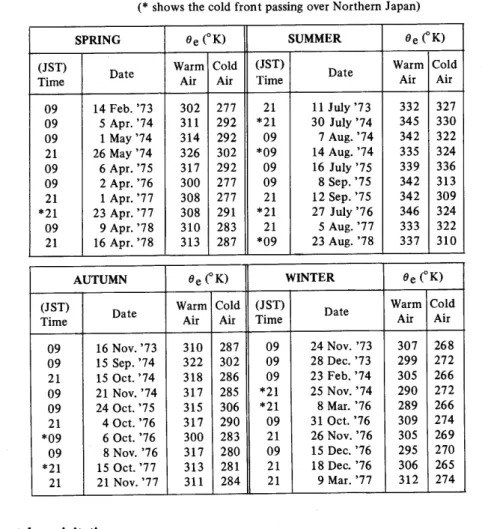
(1973〜1978)10cases in each season,40 cases in a皿, have been chosen. The dates andθε of the cold or warm air・masses in the respective cases have been arranged in Table 1.
Acold丘ont has a severe horizontal曲ear. In this study the passage of a cold front has been defned as the change ofwind direction from SW to NW .
Table l Dates and e e of cold or warm air・masses i1 each case (*shows the cold fr. ont passing over Northern Japan)
SPRING θe(°K) SUMMER θe(°K)
(JST)
sime Date
Warm
̀ir Cold
̀ir
(JST)
sime Date
Warm
̀ir Cold
̀ir
09 14Feb. 73 302 277 21 11July 73 332 327
09 5Apr. 74 311 292 *21 30July 74 345 330
09 1May 74 314 292 09 7Aug. 74 342 322 21 26May 74 326 302 *09 14Aug. 74 335 324
09 6Apr. 75 317 292 09 16July 75 339 336
09 2Apr. 76 300 277 09 8Sep. 75 342 313
21 1ApL 77 308 277 21 12Sep. 75 342 309
*21 23Apr. 77 308 291 *21 27July 76 346 324
09 9Apr. 78 310 283 21 5Aug. 77 333 322
21 16APL 78 313 287 *09 23Aug. 78 337 310
AUTUMN θe(°K) WINTER θe(°K)
(JST)
sime Date
Warm
̀ir Cold
̀i正
(JST)
sime Date
Warm
̀k
Cold
̀ir
09 16Nov. 73 310 287 09 24Nov. 73 307 268
09 15Sep. 74 322 302 09 28Dec. 73 299 272
21 150ct. 74 318 286 09 23Feb. 74 305 266
09 21Nov. 74 317 285 *21 25Nov. 74 290 272
09 240ct. 75 315 306 *21 8Mar. 76 289 266
21 40ct. 76 317 290 09 310ct. 76 309 274
*09 60ct. 76 300 283 21 26Nov. 76 305 269
09 8No肌 76 317 280 09 15Dec. 76 295 270
*21 150ct. 77 313 281 21 18Dec. 76 306 265
21 21Nov. 77 311 284 21 9Mar. 77 312 274
Cold frontal precipitation
The precipitation丘ρm the cloud bands along the shear血1e has been i}terpreted as cold frontal precipitation. By means of the surface weather charts every 3 hours and the daily original registers of meteorological observation, the cause of each rainfal1 has been probed at 140 stations all over Japan, and the starting and finishing time s of the cold frontal precipitation have been determined and then the amount of the precipitation has been calculated.
In the stations where the center of an extratropical cyclone passes to the north within a few hundred km, if there is an interruption in precipitation or if the hourly precipitation reaches a minimum between the wa㎜丘ont and the cold front as the wind changes direction(from SW to NW), then these two types of precipitation can be distinguished.
Of course,血the stations where a cyclone passes to the north farther than a few hundred
㎞,the cold frontal precipitation is expected.
In this study, the pre・frontal squall due to the血stabihty止㎞e and the post・frontal squan due to the secondary丘ont are血cluded血the cold frontal precipitation. On the other hand,
precipitation due to some causes unrelated to the cold丘ont should be excepted.
Precipitation due to Winter monsoon
It is we皿known that the Japan Sea side of Japan has much snow due to the changing in quality of the Siberian air−mass in winter・
The features that we find usefu1血dist加guishing the precipitation due to the winter monsoon from any other precipitation are as fbllows. First of all, after a cyclone passes eastward, the interruption or minirnum amount of the precipitation can very often be recognized. In addition, the Siberian high has its center over止e continent above 40°N, and the atmospheric pressure at sea・1evel of the station under study is more than 1000mb as standard.
3.Contributing Rate of Cold Frontal Precipitation
In order to know the contributing rate of the cold frontal precipitation to the annua1 or monthly amount of precipitation, Figure 3 has been drawn up using data from l l stations in 1974. These data have been got on the basis of hourly precipitation referred to weather charts(09JST,21JST)and in some cases photographs by NOAA 4.
This year there were somg unique cases such as the rather longer stay of the Bai−u front,
but there was no large deviation of血e precipitation at any stations. Ogawa(1977)has reported the distributions of f「onts in 1974 which are worth comparing.
Wakkanai
The cold血ontal precipitation occurs血autu㎜, because血e North Paci臼c anticyclone becomes weak and cold fronts move southward. The annual rate is only slightly above 1%,
in contrast to the rate due to the winter monsoon(about 20%), because the warm, wet I虹r・mass along a cold front is hard to flow over.
Nemuro
The cold frontal precipitation is as little as that due to the winter monsoon. This is generally the case with the Pacific side of Eastern Japan.
Akita
The cold血ontal precipitation does not occur in early summer, but the amounts血crease in the other seasons, mainly in October, so that the annual rate amounts to nearly 20%and it is not so much different from the precipitation due to the winter monsoon(23%).
Miyako
The annual rate is as low as 4%. The difference from that in Akita is surely caused by the orographic controls. In summer the cold frontal precipitation occasionally occurs,
because the passing cold front is apt to cause heat−frontal thunderstorms.
Wajima
There is a tendency similar to that observable in Akita, but the amounts due to(1)(2)(4)
in Chapter 1 at Wajima are respectively greater than at Akita.
●
.●●●●
●
●
2 5 8 11
1214.5(1212)mm
WAKKANA夏
mm
300 200 100
100 ●●
●
●● ●●
●
●
●
2 5 8 11
914.5(1077)mm
NEMURO
●●
●
●
●
:・:・° ●
2
●
●
● ●
2 5 8 11
2036.0(2382)mm
WAJIMA
N塾1†
●
●
●・●● 200
●
● ● ● ●
● ::: 100 ● ●
●
o●. ● ●
9・・
5 8 11 2 5 8 111
.0(1307)mm 1122.5(1289)mm
AKITA MIYAKO
\ ●
200 ●
●
100 ● ●
● ● 200
● ●● ● 100
@ イ
@ o KM 500 2 5 8 11
2361.5(2171)mm
IZUHARA ● ●
● 5
●
●
.●
500 D400
R00 Q00 P00
●
@ ●
@ ● 怐怐
@ 5
ρ●
●
8 11 2 8 11
2448.5(2118)mm 1516・5(24433)卿
NAHA KAGOS田MA
■ 隔
●
●
@ ●
@ ●
怐
●
●
●
●
2 5 8 11
2903.0(2785)mm
SHIONOMISAKI
2 5幽 8 11
1522.0(1729)mm
CHOSHI
400 300
200」
100
●
●
●
●
●
●
●
●
2 5 8 11
2636.5(3284)mm
HACHIJO−JIMA
、\ ● Mean Monthly Precipitation(1941〜1970)
、、 {
due to Cold Front due to Tropical Cyclone due to Winter Monsoon due to the Otler Causes
Annual Precipitation(1974)and Mean Annua1 Precipitation(1941〜1970)
Fig.3Monthly precipitation(1974)classified by synoptic causes at the selected stations
Choslli
lhe slight cold frontal pre cipitation appears only血spr血g and autu㎜, and the annual rate is less than 1% the least㎞a皿the stations. The cold血ontal precipitation is greatest in autu㎜(16%㎞November), but the annual rate is less血an 10%, for the centers of cyclones pass very often in the neighborhood・
Hachijo−jima
As far as a norma1 year it rains most abundantly in autumn, mainly because the influence of polar fronts(ミhu・rin)and typhoons, part1y because the passage of cold fronts・
Shionomisaki
Since the rate due to cold fronts amounts to 15%in Apri1, the annual rate becomes 3%,
but in many poi lts it resembles the case in Choshi.
Izuhara
The cold frontal precipitation is great in spr血g and autu㎜, and espec凶y in May when the rate amounts to 28%due to May storms .Though precipitation due to winter monsoon seldom occurs, the annual rate due to cold frorits amounts to about 10%, so that Izuhara belongs to another type,different from the type of Akita and Wajima.
Kagosllima
The rate in May amounts to 28% as in the case of Izuhara. From late winter to early summer the rate is higher and the annual rate(10%)is not different from血e rate血nuenced by tropical cyclones(15%),whose annua1血crease or decrease is greater.
Naha
The cold f『ontal precipitation occurs from November to July, in other words during the period except summer and early autumn. When止e Siberian a廿一mass overnows remarkably in whlte r, the monthly rate reaches a minimum(February in 1974, but January in a normal year), but as a whole the precipitation due to the passing of the polar fronts is notable in the
cold half year. The annual rate is strongly controlled by typhoon, but in either case the Nansei(Sou1血western)Islands including Naha perhaps has the highe st rate aU over Japan.
4.Occurrence Frequency of Cold Frontal Precipitation
Choice of objects
The criteria adopted when the objects of this study were chosen are as fbllows:1)The cold front has been analyzed on the surface weather chart drawn by the Forecast Depart−
ment of the Japan Meteorological Agency.2)When the cold丘ont passes, the wind change can be clearly observed at many stations.3)At any station the cold frontal precipitation is smm or more.4)The cold丘ont passes輌thout stopp血g.5)There is no wave cyclone on血e cold front befbre its passage over Japan.6)The cold front is not a part of coupled cyclone
(one passes through the Japan Sea and the other passes along the southern coast of Japan)・
Annual frequency
The occurrence frequency of the cold frontal precipitation, which is Omm or more and smm or more, has been Mustrated血two figures(Fig.4a,4b). They represent a pronounced colltrast between both sides of the central mountain range in the Japanese Islands. However,
the distribution pattem of the frequency is not as marked as that of precipitation due to w㎞ter monsoon(Suzuki,1962;Kawamura,1964), and the steep・gradient area of the occurrence frequency of the cold frontal precipitation shifts more or less toward the Pacific coast. The author is of血e op血ion that the high frequency area of 5mm or more and the low frequency area of Omm or more respectively correspond to the frequent occurring areas of anafront and katafront , which Bergeron(1937)pointed out for the first time and Sansom(1951)investigate d in detail in E叫罫and.
〉イ70
20
〆〆40
Fig 4 Annual occurrence frequency(%)of cold fronta1 precipitation(CFP)
Fre(luency of each season
The occurrence frequency of the cold frontal precipitation which is 5mm or over has been drawn about every four seasons(Fig.5).
First of an,血regard to血e case血spr血g, autu㎜, and w血ter,止e low rate血w血ter血 the Kyushu district is conspicuous and a few differences according to the seasons are recognized, but the two high rate areas in the region fac血g the Japan Sea and i㎞ the environs of the I zu Islands, and the low rate zone between them are clearly differentiated.
The most characteristic distribution is seen血summer. As compared with血e o血er
seasons, the rate of the Izu Islands and its vicinity is lower, but the high rate area along the Japan Sea is wider and spreads over the mountains to the Pacific side of Eastern Japan.
1
〔コ≧3q t・
SPRING
o
・
AUTUMN
50
WINTER
1 5070 50
壷
/
KM 500
Fig 50ccurrence frequency(%)of cold frontal precipitation(≧5mm), according to seasons
5.Analyses of Lower Atmosphere
Case study
Afew days around 310ct.1976 are chosen as a typical instance(Fig.6), and the special quahty of the atmospheres is analyzed on the 850mb surface, where low level jet streams are apt to occur befbre or after cold丘onts pass. The prosperity and decay of the jet wm exert considerable influence on the cold frontal precipitation.
The wild isoplethes with two sections along the Japan Sea and along the Pacific Ocean have been made, ad(ling the different amounts of temperature and relative humidity every
12hours(Fig.7). In this analysis the change from WSW to W of wind direction has been recognized as the passing of a cold frontal surface.
3
//
100レ・
1
_L」LCF:no pass
ノ
JST
mb
CFP:
10mm
5・・10mm
O−5mm
nothing
Fig,6Passjng locations of cold fronts(CF)and distributions of cold frontal precipitation(CFP)
(卜1・一一一一一一←31−一一一一→咽←一一一一30−day
21 21
time
う
つ−
世.?/」 ・
繕
謬
俺
郎磐演:::薄鹸演無
鹸.iト:萱:1・1・:::専:
『10
wind Direction
Retative Humidity.
琴ii黛鷲i濱言言読
AK1TA… 。・・。.
・ ・ ● ・
》VAJrMA..・・。。
.●
● ●
YO NAGO・・… . . ■ .
● ●
FUKU− .
ら サ
OKA・… 。, ・.
. 1976 °・ ・ ■ .
Oct. ° °・
NNov. . .,・:
ら ロ ロ
Mls酬A_.・ ζ .
°・ .:∵
..≒・°°
5ENDA1・・… 。°
・,
魯●°
● ● ● . .
τATENO・・・… .
●.
. o ●HAMA− ..。 ° ● MATst」・… 。 SH:ONO− ..・
MISAK1・。… °°
KAGO− ......
SH1MA・・・… °
Al「播耀「;.9・9t2h,s o 2.0当1△TlS3,9
0 4。051ムTl559
8
6051ムTl57.9 80蓬1ムTl≦99
0up ●down
●
■
。・∵
N\イ
0 300 km
一一一
■
Fi&7Space and time analysis chart of atmosphele on 850mb surface, and the stations of upper 血observation
It is a characteristic on the Japan Sea side that the SW hot, wet low level jet prevails
(Wajima:09JST,310ct.:θe=307°K, wind speed=31m/sec). In contrast, on the Pacific Ocean side the NW cold, dry low level jet genera皿y prevails(Tateno:09JST,310ct.:292°K,
22m/sec).
inductive characteristics of lower atmosphere
In order to comprehend inductively the prosperity and decay of the jet befbre or after acold front passes, the max㎞um wind speeds classified by the components of south and north have been surveyed, and the occurrence frequency more than 20m/sec and their wind roses have been i皿ustrated(Fig.8).
Wind Rose 奄imes 10 5 0 N L」LL昌・Lコ」●
300km
一一一
十
・咳ダ
/4°
Fig 80ccurrence frequency(%)and wind roses of maximum wind speed≧20m/sec classified by whld曲ection(85 Omb)before or after passing of cold front
6.System of Cold Front
Winter(sp血g, a耐umn)
In winter the system of typical cold fめnt is inustrated(Fig.9)when it exists in the area facing the Japan Sea(a)and in the area facing the Pacific Ocean(b). Lengths of the arrows are propor廿onate to w血d speed. In spr血g and autumn this system is alike except 4.
1:Cold f辻ont
2:Pre・frontal squaU due to the katavatic warm air from the fronta1 surface and the warmer,
wetter air・mas s(Omoto,1965), namely, due to the pre−fronta1 waves(Eagleman,1980)
3:Secondary front due to the fresh colder air−mass and the rather warmed air 4:Clouds(Cu)due to winter monsoon
J1:WSW upPer jet stream J2:WNW upPer jet stream
J3:SW warm, wet low・1evel jet stream J4:NW cold, dry low−level jet stream
Summer
In summer the system of a typical cold front is illustrated in Figure 10.
5:Thunderstorm(Cb)caused by E or SE warm, very wet advection J5:WSW relatively weaker upPer jet stream
J6:WNW relatively weaker upPer jet stream
ノ「\一一一 e >\J1 /
①
0 300km
」一 J2/
colder oirゆ・
n』」4
①
Fig 9 System of a typica1 cold front in winter
10
5
0 15
10
5
①
、 J5
/ノヨ
cold oir
kg ii多響
Fig。10 System of a typical cold front㎞
summer
7.Conclusion
Active cold frontal area
R。ughly P・ealdng, thi・i・th・area・f m・・e than 30%in・FigU・e 4b;血e a・ea鉛・ing the
」、卿S・a・・th・E・・t−C㎞・Sea(血・1ud血g th・N・n・ei l・land・)・・nd th…uth・・n・part・f the I zu Islands. In the typical cases the SW warm, wet low・level jet f[ows along the southern
・dg・・f the c・ld f・・nt. A・a・e・Vlt, th・p・ecipit・ti・n血t・面ty bec・m・・9reat・・and the occurrence丘equency of 5mm or more is also higher.
In the northwestern side of Central Japan, it beg血s to rain a few hours, or just, before th・passing・f a c・1面・nt,・nd th・p・ecipit・ti・n du・ati・n t・nd・t・bec・m・1・ng・・becau・e
・fth・p・・t一丘・ntal・・lu・ll cau・ed by th・・ec・nda・y丘・nt・ln血・1・u l・1・nd・th・p・ecipit・廿・n 血t,n,ity・nd du・ati・n t・nd t・b・・e・pecti・・1y・t・・ng・・and・h・・t・・b・cau・e・f th・
pre・frontal sqμaU caused by the unstable convergence 1血e・
From the viewpoint of water resources, the most ilnportant considerations are the P・ecipit・ti・n du・t・th・曲t・・m・n…nin止e a・ea飴・血9血・J・p・n Sea・・nd th・p・ecipita°
廿。n du, t。 t・・pi・al・y・1・n・・血th・N・n・ei I・1・nd・, but the c・ld・fr・姻p・edpit・ti・n i・・f secondary importance in both areas.
Unactive cold frontal area
This is the area of legs than 60%in Figure 4a;most of the area facing the Pacific Ocean.
Acold front is not active and the occurrence frequency of the precipitation is lower. Even if it rains, it does so only a httle. The factors that cause such an unac位ve front are the da㎜血g up of cumuh by血e mounta血barriers,血e㎞仕equent血flow of the warm air−mass
due to the presence of the masses of mountains, and the adiabatic heating of the cold air by the katabatic wind on the leeward side of the mountai血s.
Summer active cold frontal area
This is the area of more than 30%血Figure 5(summer), which covers the greater part o f Eastern Japan. Most of the part facing the Pacific Ocean in this area, though terms low 蜘ency訂eas for the year, is high frequency areas , as far as the summer is concerned.
In summer the significant advection arises from止e east or southeast to血e mounta血s of Central Japan on the extra low−level(near the 900mb surface)befbre the passing of a front,
and then thunder clouds appear. However, since the rainy area due to the thunderstorm is
㎞ted by its appearing position, moving direction, and life・span, rain is hardly observed hl the Izu Islands and its environs. On the mountains in Central Japan it can also be pointed out that the front passes ear血er血this case,though it generally passes later.
Acknowledgement
The author wishes to express his sincere gratitude to Professor Ikuo Maejima of Tokyo Metropolitan University for his instructive guidance through the course of this study.
References Cited
Bergeron, T.(1937):On the physics of fronts. BulL A〃霊.・Ueteor.5bc.,18,265−275.
Eagleman, J. R.(1980):MeteorologアーThe.A tmosphere加、4 c施〃. D. Van. Nostrand Company, New York,384p.
Fukui, E.(ed.)(1977):77zeα 〃tate oアノbpan. Kodansha, Tokyo,317p.
Kawamura, T.(1964):The synoptic climatology of winter monsoon in Japan.**Geogr. Rey. o∫」勿ση,
37,64−78.
Maejima,1,(1980):Seasonal and regional aspects of Japan s weather and chmate. In the Association of Japanese Geoglaphers:Geography of/iZpan. Teikoku−Shoin, Tokyo,54−72.
Ogawa, H.(1977):Nihon shuhen niokeru tsuki−betsu no zensen bunpu(The monthly distributions of fronts in Japan and its surroundings)(1974).*In Minato, M.(ed.):」ψ〃〃a〃d its Nature. Heibonsha,
Tokyo,36−37.
Omoto, Y.(1965):On pre−frontal precipitation zones in the United States.」碑r. Me teor. Soc.ノbpan,43,
310−330.
Sansom, H. W.(1951):Astudy of cold fronts over the British Isles.2uart.ノと)ur. Roア. Me teor. Soc.,77,
96−120.
Suzuki, H.(1962):Klassifikation der Klimate von Japan in der Gegenwart und der letzten Eiszeit. Japan.
Jour. Geol.σθogr.,33,221−234.
Yamakawa, S.(1980):Asynoptic climatological study on cold frontal precipitation in Japan.**(}θogア.
Rev. of Japa〃,53,574−588.
Yazawa, T.(1980):Der Ablauf der Jahreszeiten in Japan aus der Sicht der Witterungskhmatologie und seine Bedeutung fUr das Japanische Leben. Er(ikunde,34,88−95.
Yoshillo, M. M.(1980):The Climatic Regions of Japan. Erdkunde,34,81−87.