GEOGRAPHICAL REPORTS
OF TOKYO METROPOLITAN UNIVERSITY 56 (2021) 59–71
TIDAL-FLAT SEDIMENT AS AN ENVIRONMENT FOR BENTHIC MICROALGAE IN SOUTHEAST ARIAKE BAY,
KYUSHU, JAPAN
Kenta YAMADA*
Abstract The physical and chemical properties of sediment in the tidal area of the Shirakawa River in Kyushu, Japan were studied to obtain knowledge of the habitat of benthic microalgae in Ariake Bay. Sediment samples from the foreshores of southeastern Ariake Bay and estuarine tidal flats in the Shirakawa River were collected during the normal stage of water during high tides in September and November 2016. The particle size distributions in sediment and the amounts of chlorophyll a and volcanic glass shards were examined in core samples. The elemental compositions of bulk sediment samples and agglomerated particles were measured by energy dispersive fluorescent X- ray analysis (EDX) and scanning electron microscopy energy-dispersive X-ray spectrometry (SEM- EDX), respectively. On the basis of the grain-size composition, the the estuary and the foreshore- right cores were identified as sandy tidal-flat sediment, and the foreshore-left as muddy tidal-flat sediment. Volcanic glass particles derived from Aso Caldera were more abundant in the estuarine cores and the foreshore-right cores than in the foreshore-left cores. The contents of iron and phosphorus were relatively high in the estuarine cores. The SEM-EDX mapping revealed that iron and phosphorus were correlated with each other on the aggregated particles, indicating that iron hydroxides derived from volcanic-ash soil and volcanic ash act as phosphorus carriers in the study area. It was suggested that dissolved iron from the upper Shirakawa River may rapidly aggregate and precipitate at the front edge of the estuary tidal flat and combine with phosphoric acid, providing a phosphorus source for benthic microalgae.
Keywords: foreshore tidal flat, estuary, benthic microalgae, aggregated particles, volcanic glass
1. Introduction
Tidal flats are formed in areas where there is a sufficient supply of fine-grained sediment and tides dominate over other hydrodynamic forces (Gao 2019). Tidal flats may be foreshore tidal flats or estuary tidal flats (Akiyama and Matsuda 1974; Komatsu 2004). The “foreshore” is the land area that emerges at low tide and corresponds to the intertidal zone, between the high and low tide lines.
Foreshore tidal flats form alongside the coastline and have a large area and high environmental stability, whereas estuary tidal flats are generally small in area and are susceptible to physical disturbances such as freshwater inflow, erosion, and sedimentation. Approximately 60% of tidal flats in Japan are foreshore tidal flats and 30% are estuary tidal flats (Furota 2006).
* Regional Energy Strategy Team, Sustainability Design Division, EX Research Institute Ltd.
A tidal flat is an environment where abundant organic matter and nutrients are supplied from the land and is characterized by coexistence of benthic and planktic organisms in a limited space (Imai 1989; Kikuchi 1993). For this reason, in shallow coastal waters, including tidal flats, both phytoplankton and benthic microalgal primary producers contribute to photosynthetic activity (Clark 1974; Imai 1989; Goto 2002). Of these primary producers, benthic microalgae play an important role in the predatory and detrial food chains in tidal flats in terms of primary production efficiency and their utilization by bacteria and benthic organisms (MacIntyre et al. 1996). In addition, the habitat of organisms and material cycling in tidal flats are closely related to oxidative decomposition and nitrification caused by bacterial activities, and oxygen supply through photosynthesis and secretion of extracellular organic substances (Imai 1989; Goto 2002; Yamamoto 2009).
The distribution of benthic microalgae in coastal areas is influenced by light intensity, nutrients, salinity, and particle size composition (Kodama et al. 2002; Ichimi et al. 2008). Baird et al. (2004) pointed out that resuspension of sediments by tidal and wave forces changes the amount of light reaching the sediment surface and has a significant effect on the distribution of benthic microalgae.
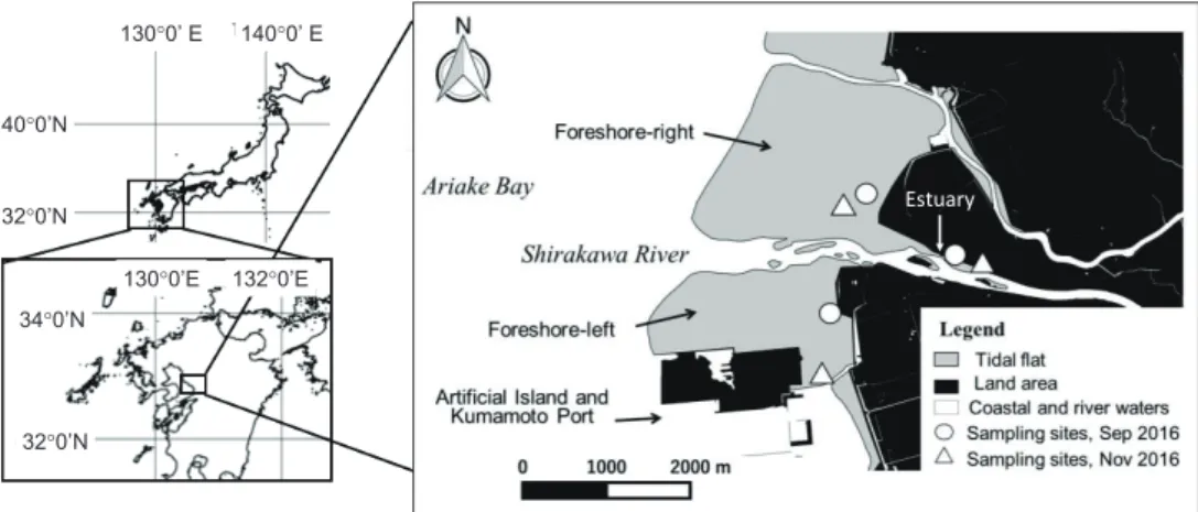
Therefore, benthic microalgae attached to the surfaces of sediment particles can be more influenced by the physical and chemical properties of sediments than phytoplankton. The aim of this study was to elucidate the physical and chemical properties of tidal-flat sediments in the foreshore and estuary tidal flats on the southeast coast of Ariake Bay, Kyushu, Japan (Fig.1).
2. Material and Methods
Hydrographic conditions of the study area
The southeast coast of Ariake Bay has low salinity and is greatly affected by river inflows to the bay (Kondo and Daita 1980). Along the southeast coast of the bay, a vast foreshore tidal flat has developed because of the tidal range of approximately 4 m (Takigawa et al. 1999; Suetsugi et al.
2002). The estuary tidal flat in the Shirakawa estuary adjacent to the foreshore tidal flat is also affected by high and low tides and extends along the riverbanks to approximately 5 km upstream from the river mouth.
Aso Caldera locates in the upper Shirakawa River and tephra sediments containing volcanic glass are supplied from the catchment area. The area around Kumamoto city, which is in the lower Shirakawa basin, has been seriously affected by the accumulation of tephra sediments due to floods of the Shirakawa River (Tanoue and Kamimura 1998). This sediment supply from the Shirakawa River also causes large changes in the tidal-flat topography around the Shirakawa estuary, and the tidal-flat deposits contain mineral particles such as plagioclase and volcanic glass that originated from Aso Caldera (Suetsugi et al. 2002).
The sedimentary environments of the foreshore tidal flats on the southeast coast of Ariake Bay differ between the right and left banks of the Shirakawa River. Numerical modeling of the area around the Shirakawa estuary and Kumamoto Port has demonstrated that wave height tends to be higher on the right bank than on the left bank (Yamada et al. 2000; Uzaki et al. 2009). In addition, calculation of the wave field during a typhoon indicated that there was a break point on the tidal flat on the right bank, but the break-point distribution was not clear on the left bank (Yamada et al. 2000).
These results suggest that the Kumamoto Port, which protrudes out from the shore, influences the
sedimentology of the area, and active sediment movement is presumed to occur on the right-bank
tidal flat. The foreshore-right tidal flat is also greatly affected by residual tidal currents and is
influenced by input of organic matter from the Shirakawa River (Takigawa et al. 1999; Takigawa and Tabuchi 2002), associated with bottom sandy sediment that maintains the aerobic environment as a preferable ground for a clam fisheries (Tsutsumi 2005; Ministry of the Environment 2006).
Sampling sites and collection
We set three sampling areas, the Shirakawa estuary, the foreshore-left tidal flat, and the foreshore-right tidal flat (Fig. 1). Cores of tidal-flat deposit were collected using a PVC tube, diameter φ 60 mm (inner φ 59 mm) at the normal stage of water during high tide. As some types of benthic microalgae inhabiting sediments move vertically with tidal changes and alterations of light intensity (Admiraal 1977; Consalvey et al. 2004), the core samples were collected from the surface (0 cm) to 30–40 cm depth. Two cores, core 1 in September 2016 and core 2 in November 2016, were obtained in each area. The collected cores were enclosed in a polystyrene foam container and stored vertically in cool, light-shielded conditions.
Fig. 1 Location of the study area and the sampling sites.
Core sample analyses
Sediment samples were collected by every 2 cm from 0–20 cm depth. Analyses of particle size distribution, volcanic glass content, elemental composition, and total chlorophyll a were conducted on the cores. The surface structures of agglutinated particles were studied by electron microscopy.
The analyses were carried out at Laboratory of Environmental Geography, Tokyo Metropolitan University, Tokyo, Japan.
Particle size distribution
The relative weights (wt %) of the silt fraction (0.002–0.02 mm) and clay fraction (<0.002 mm) were determined by the pipette method (Gee and Bauder 1986). The operation was performed in triplicate, and the average value for each fraction calculated. The sand content (0.02–2 mm; wt %) was calculated by subtracting the silt and clay contents (%) from the total sample weight (100%).
1300’ E 1400’ E 400’N
320’N
1320’E 1300’E 340’N
320’N
Estuary
Volcanic glass content
Samples weighing approximately 3 g were obtained at 2-cm intervals from each core. These 3- g samples were treated using an ultrasonic cleaner (UT-206, SHARP, Osaka, Japan) at 37 kHz for 10 min, 10–13 times and the suspended fine particles were removed by washing. The fine sand fraction (0.1–0.2 mm) was obtained by wet sieving and then dried in an oven at 60°C for 1 h. The volcanic glass content (count %) was obtained by counting the numbers of each of three types of volcanic glass particles (bubble-wall type, small-bubble type, and sponge type) in approximately 300 particles of the fine sand fraction under a stereomicroscope (magnification ×100).
Elemental composition
Sediment samples were air-dried and then applied for elemental analysis using an energy dispersive X-ray spectrophotometer (EDX-8000, Shimadzu, Kyoto, Japan). The measurements were conducted on samples from the upper parts of the cores (0–20 cm).
Surface structure observation and elemental analysis of aggregated particles
The surface structures of the aggregated particles, which were collected from a suspension of the clay fraction, were observed by scanning electron microscope secondary electron imaging.
Elemental mapping of silicon, aluminum, iron, calcium, and phosphorus in the particles was carried out using an energy dispersive X-ray elemental analyzer in combination with a scanning electron microscope (Miniscope TM303 Plus, Hitachi, Ltd., Tokyo, accelerating voltage 15 keV).
Total chlorophyll a
Total chlorophyll a is chlorophyll contained in microalgae, which may be of benthic or planktic origin. In intertidal zones and shallow waters, benthic species tend to represent the majority of the living microalgal cells present on the seafloor (Sullivan 1999); therefore, the total chlorophyll a in surface sediments is regarded as a reliable indicator of the benthic microalgal biomass (Sarker and Yamamoto 2009; Yamaguchi 2011). In this study, the total amount of chlorophyll a was measured to confirm the occurrence of benthic microalgae under the assumption that most of the total chlorophyll a in the tidal-flat sediment was derived from benthic microalgae. The total amount of chlorophyll a per dry weight of sediment (μg/g DW) was obtained according to the following procedure.
About 10 g of wet sample was put into an Erlenmeyer flask with 20 ml of 90% acetone solution, and left to stand in a cool, dark environment for 24 h. The sample was then poured into a 50-ml tube and centrifuged (H-103N, Kokusan, Tokyo, Japan; 3000 rpm, 10 minutes) to obtain the supernatant.
The absorbance of the supernatant was measured with a spectrophotometer (PASCO, PS-2600) at wavelengths of 665, 645, 630, and 750 nm. The total amount of chlorophyll a (μg chl.a g
−1) was calculated using equation (1) (UNESCO 1966).
chl.a (μg g
−1) = 11.64 E663 − 2.16 E645 + 0.10 E630 (1)
where E663, E645, and E630 represent the absorbance values obtained by subtracting the
absorbance at a wavelength of 750 nm from the absorbances at wavelengths of 663, 645, and 630
nm. The dry soil coefficient, i.e., the ratio of the weight of the sample after oven-drying at 105°C for
24 h to that of the wet sample, was obtained to measure the total amount of chlorophyll a per dry
weight. The total amount of chlorophyll a was measured in triplicate, using three sets of 10-g wet
samples collected at 2-cm intervals from each sediment core. The absorbance of the extract was
measured once for each 10-g sample.
3. Results
Properties of sediment core samples
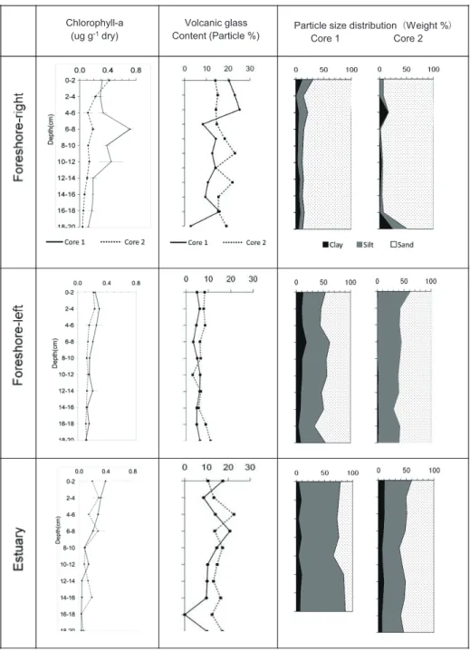
The particle size distributions of the core samples are illustrated in Fig. 2. On the foreshore-right tidal flat, the sand content (0.02–2 mm) of cores 1 and 2 was generally >70%, and the silt content (0.002–0.02 mm) was usually <25%. The sand content at 20–26 cm depth in core 1 was greater than 25%. The clay content (<0.002 mm) was approximately 10% or less in both cores; exceptionally, the clay content at 18–20 cm depth in core 2 was high (>20%). The sand, silt, and clay contents of the two cores collected from foreshore-left were 40%–65%, 40%–60%, and <25%, respectively, in all layers, although the clay contents were markedly lower in core 2 than in core 1. In the estuary tidal-flat samples, the sand, silt, and clay contents of the two cores were 20%–70%, 25%–90%, and
<10%, respectively. In the tidal-flat sediment classification scheme of Reineck and Singh (1980), the foreshore-right and estuary are sandy tidal flats, and the foreshore-left is a muddy tidal flat.
The distribution of volcanic glass in the cores is plotted in Fig. 2. The volcanic glass contents of estuary tidal-flat cores 1 and 2 ranged from 8.6% to 22.6%, with maximum values of 20.7% and 22.6% at depths of 6–8 and 4–6 cm, respectively. In sediment core 2 of the foreshore-right, there were two distinct peaks of volcanic glass, at 10–12 cm (23.1%) and 12–14 cm (20.2%). The volcanic-glass contents of cores 1 and 2 from the foreshore-left were relatively low (<10%) at depths of 0–22 cm, with vertical fluctuations that were small compared to those in the estuary and foreshore-right cores.
The total amount of chlorophyll a in core samples varied from 0.04 to 0.71 μg g
−1DW, and the maximum value of total chlorophyll a in each core was observed at the depth of 0–10 cm (Fig. 2).
The maximum chlorophyll a values of the cores were 0.71 μg g
−1DW (depth 6–8 cm) in core 1 of the foreshore-right , 0.42 μg g
−1DW (depth 0–2 cm) in core 2 of the foreshore-right , 0.29 μg g
−1DW (depth 2–4 cm) in core 1 of the foreshore-left, and 0.39 μg g
−1DW (depth 0–2 cm) in core 1 of the estuary. In estuary core 2, there were two chlorophyll a peaks (0.29 and 0.28 μg g
−1DW) between the surface and 8 cm depth. In contrast, the total amount of chlorophyll a in cores 1 and 2 of the foreshore-left was 0.04–0.29 μg g
−1DW from the surface layer to 36 cm depth.
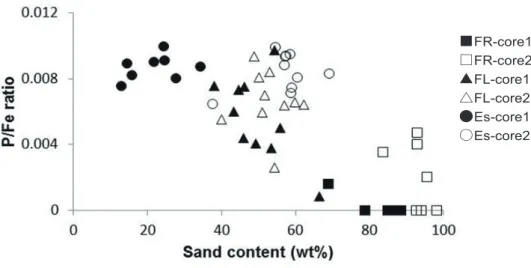
The EDX analyses of estuarine and tidal-flat sediments showed that the Fe content (wt %) was 19.51%–21.09% in the estuary, 16.67%–18.39% in the foreshore-left , and 17.42%–23.36% in the foreshore-right. The phosphorus contents (wt%) were 0.13%–0.21% in the estuary, 0.01%–0.2% in the foreshore-left, and 0%–0.09% in the foreshore-right (Fig. 3). Thus, the foreshore-right was characterized by low P and high Fe contents, and the estuary samples exhibited relatively high P and Fe levels compared to the other locations. The ratio of P to Fe (P/Fe) of tidal-sediment samples decreased as the sand content increased (Fig. 4).
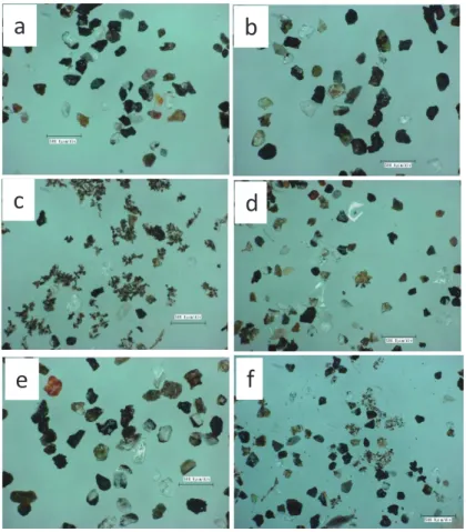
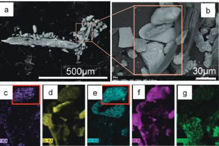
Characteristics of aggregated particles
Optical microscope observation revealed that aggregated particles were composed of fine particles together with volcanic glass shades, plagioclase, and diatoms. The maximum sizes of the aggregated particles were 100–200 μm (Fig. 5). Reddish or blackish oxides were present on the surfaces of feldspar and volcanic glass particles in the sand fractions of the core samples from the three sites.
The results of the SEM-EDX elemental mapping of aggregated particles from the foreshore- left
tidal flat are illustrated in Fig. 6. Major elements detected were Si, Al, Fe, Ca, and P. Areas of high
P content also exhibited high Fe and Al levels (Figs. 6c, e, f).
Fig. 2 Total chlorophyll a; volcanic glass content (%); and contents of sand, silt, and clay (%) in the tidal- flat sediments collected from the right foreshore, left foreshore, and estuary.
Chlorophyll-a
(ug g-1 dry) Volcanic glass
Content (Particle %) Particle size distribution㸦Weight %㸧 Core 1 Core 2