Documenting 19th Century Typhoon Landfalls in Japan
Michael J. Grossman* and Masumi Zaiki**
Abstract
Japan is located in the Western North Pacific basin, the most active tropical cyclone region in the world. For the most recent normal period (1981-2010), an annual average of 25.6 typhoons formed in the basin with 5.4 of those storms coming within 300 km of the four main islands of Japan. Throughout the history of Japan, typhoons have been a major hazard bringing strong winds, high waves, and heavy rainfall with flooding and landslides to the country nearly every year. With or without potential changes in typhoon frequencies and intensities caused by anthropogenic climate change, typhoons are a significant problem for Japan. Most studies of typhoons in the Western North Pacific depend on modern data dating back only to 1951 with the more accurate satellite observations beginning in 1965. As a result, our understanding of typhoon behavior over the long term and under differing global climatic conditions remains incomplete. However, records and data do exist for earlier periods and can be used to reconstruct typhoon histories. Such records can used for periods that have no instrumental data and to add detail to periods with limited data.
In our research, we use data from historical documents to reconstruct a list of typhoons affecting Japan in the 19th century and to describe and map these typhoons. We use data from: 1) Japanese historical documents including official and private diaries that have been entered into a Historical Weather Database; 2) Japanese government and academic compilations; 3) weather observations and compilations from outside Japan; 4) English language newspapers published in Japan; 5) Japan Imperial Meteorological Observatory Maps and Records. Combining data from these multiple sources makes it possible to reconstruct a meaningful record of typhoons of the past. This paper will review the data and methods we used, discuss some results to date, and preview potential uses for this research.
I. Introduction
1Japan is located in the northern part of Western North Pacific basin, the most active tropical cyclone region in the world with about one-third of the world’s tropical cyclones originating there each year (Elsner and Liu 2003). According to the Japan Meteorological
* Associate Professor, Department of Geography, Southern Illinois University Edwardsville, USA E-mail: [email protected]
**Associate Professor, Faculty of Economics, Seikei University E-mail: [email protected]
1 Acknowledgment: I would like to thank the Center for Asian Pacific and Studies (CAPS) for supporting
the research described in this paper with a Fellowship for Visiting Researchers in the fall of 2012. I would also like to thank the CAPS staff for their help and kindness.
Agency, a typhoon is a tropical cyclone with maximum wind speeds of 34 knots (63 km/ hr) or more. For the most recent normal period (1981-2010), an annual average of 25.6 typhoons (referred to as hurricanes in the Atlantic and Caribbean basins) formed in the Western North Pacific with 5.4 of those storms coming within 300 km of the four main islands of Japan (Honshu, Hokkaido, Kyushu, and Shikoku). The annual average is 11.4 per year if the Okinawa-Amami region is included (JMA 2013).
Throughout the history of Japan, typhoons have been a major natural hazard bringing strong winds, high waves, and heavy rainfall with flooding and landslides to the country nearly every year. Data for typhoon disasters indicate that 133 of the typhoons affecting Japan between 1951 and 2005 resulted in 14,659 people dead or missing, 73,680 injured, and damages costing billions of Japanese yen (Kitamoto 2008). In 2004, a record year for typhoon landfalls in Japan, twelve typhoons left more than 230 people dead or missing and caused flooding that affected 170,000 homes across the country (Ministry of Land, Infrastructure and Transport 2004). Clearly, even without potential changes in typhoon frequencies and intensities caused by anthropogenic climate change, typhoons are a significant problem for Japan.
As we move further into the 21st century, the challenges presented by global climate change do in fact add urgency to our need for better understanding of typhoons and the potential impacts climate change might have on them. Debate is ongoing as to as to how global warming might affect tropical cyclone frequency and intensity (e.g., Emanuel 2005; Pielke et al. 2005; Webster et al. 2005). A number of studies suggest that both the intensity of tropical cyclones and the frequency of strong storms has and will continue to increase. Webster et al. (2005) suggest that the number of category 4 and 5 storms is increasing in the Western North Pacific and Wu et al. (2005) found that typhoon tracks shifted westward significantly between 1965 and 2003, bringing greater numbers of typhoons to Korea and Japan. Wang et al. (2011) found that an increasing tropical cyclone influence in East Asia can be linked to global warming in sea surface temperatures and associated changes in the large-scale steering flows. Stowasser et al. (2007) used a high-resolution climate model to examine potential impacts of global warming on tropical cyclones in the basin noting that, while the total number of basinwide storms remained the same, the average strength and number of the strongest storms would increase. Park et al. (2011) also noted a recent intensification of tropical cyclones that made landfall in Korea and Japan that can be attributed to changes in large-scale climatic conditions. A recent review of global warming and hurricanes (Knutson 2013) concludes that while it is premature to state that human impacts have had an impact of North Atlantic hurricane activity, it is likely that anthropogenic warming will cause hurricanes globally to become more intense on average and that there will be an increase in the number of very intense storms. These results have important implications for Japan.
Most studies of typhoons in the Western North Pacific depend on modern data using the best track data from the Joint Typhoon Warning Center, the International Best Track Archive for Climate Stewardship or the Regional Specialized Meteorological Center in
Tokyo. These annual tropical cyclone data date only from 1951 with the more accurate satellite observations beginning in 1965. Various studies have chosen different time periods with this 1951-present range but all are limited to the post-1951 period. As a result our understanding of typhoon behavior over the long term and under differing global climatic conditions remains incomplete.
The key constraint on improving our understanding of typhoon behavior over the long term is a lack of data from before the modern instrumental period. However, records and data do exist for earlier periods. Records and data for typhoons exist for the 20th century up to World War II but have not yet been systematically examined and published. Further, limited instrumental monitoring of typhoons in Japan began with the formation of the Imperial Meteorological Observatory Japan (the predecessor of the Japan Meteorological Agency) in 1875 with weather maps and data published from 1883. For earlier periods, one approach to extending the record of typhoon behavior is the use of historical documentary records. Such records can used for periods that have no instrumental data and to add detail to periods with limited data. They can be corroborated by available instrumental data to reconstruct reliable records of storm events. In our research, we use historical documents to reconstruct a list of typhoons affecting Japan in the 19th century and to describe and map as many of these typhoons as possible. This paper will review the data and methods that we use, discuss some results to date, and preview the potential uses for this type of reconstruction.
II. Climate reconstruction using historical documents and data
Brazil et al. (2005) has defined historical climatology as a research field situated at the interface of climatology and (environmental) history, dealing mainly with documentary evidence and using the methodology of both climatology and history. One of its main objectives is “reconstructing temporal and spatial patterns of weather and climate as well as climate-related natural disasters for the period prior to the creation of national meteorological networks (mainly for the last millennium).”
Historical documents have been used to reconstruct hurricanes histories and individual storms in the North Atlantic, the Gulf of Mexico and the Caribbean. Rappaport and Fernandez-Partagas (1995 updated by Beven in 1997) compiled a history of the deadliest Atlantic hurricanes dating back to 1492 with emphasis on casualties. Blake et al. (2011) similarly list and map the deadliest tropical cyclones affecting the United States back to 1851. García-Herrera et al. (2004; 2005; 2007a) used Spanish and British documentary sources (e.g., ship logs) to investigate Atlantic and Caribbean hurricanes in historical times. Bossak and Elsner (2004) developed a historical hurricane information tool using Geographic Information Systems software to provide access to pre-instrumental U.S. hurricane information for the 19th century. Mock (2004) described the use of documentary records to reconstruct historical hurricanes in South Carolina, U.S.A. and used the same approach to detail tropical cyclones in Louisiana, U.S.A. since the late
18th century (Mock 2008). Mock et al. (2010) and Wheeler et al. (2009) have also used historical documents to reconstruct the details of individual hurricanes and their tracks. In the Western North Pacific basin, Chan and Shi (2000) used historical records from China to document typhoon landfalls from 1491-1931 and Liu et al. (2001) used similar Chinese records to extend the record of typhoon landfalls in China back to 1000 A.D. Louie and Liu (2004) reviewed using Chinese historical documents as a way to obtain information about past typhoons concluding that such records are valuable for reconstructing historical typhoon landfall in China. Elsner and Liu (2003) showed the importance of having long-term records by using a historical time series of typhoon landfalls in Guangdong, China from 1600 to 1909 to test hypotheses about the impact of ENSO and the Pacific Decadal Oscillation on tropical cyclones. Fogerty et al. (2006) also used historical records to investigate variations in typhoon landfalls over China since 1600.
García-Herrera et al. (2007b) made extensive use of historical documents in developing a chronology of northwest Pacific typhoons affecting the Philippines as documented by Jesuits in the region from 1566 to 1900. They also published their findings online as a database of a high-resolution chronology of typhoons around the Philippine Islands and the Western North Pacific basin (García-Herrera et al. n.d.). Ribera et al. (2008) extracted reports of fatalities from the same data set to chronicle the history of the deadliest typhoons that affected the Philippines. Ribera et al. (2005) also used historical documents from the Jesuits to develop a chronology of typhoons affecting the Philippines from 1901 to 1934. These studies will be discussed again in the Data section as we have also referred to their data in identifying typhoons that affected Japan.
For Japan, Grossman and Zaiki (2007) used data from historical documents to reconstruct typhoon frequencies affecting the islands from 1801 to 1830, to estimate the tracks of some well-documented historical typhoons in the 19th century (Grossman and Zaiki 2008) and to reconstruct a chronology of typhoons affecting Japan in the 1880s (Grossman and Zaiki 2009).
III. Methods and data for Japan
Because no systematic instrumental records of typhoons affecting Japan exist for the entire 19th century, it is important to begin reconstructing a list using historical documents. Japan has a long history of written record-keeping by government agencies, temples and shrines, and families. The purposes of such records differ but many include information about the weather. Extreme events and disasters such as typhoons that greatly impact society tend to be reliably recorded in historical documents.
For the first half of the 19th century, documentary data on weather is limited to private, temple, and government diaries and records. There was no official system for collecting weather data. After the 1850s, when Japan began to open itself to greater interaction with foreign countries, newspapers in English and Japanese began to be
published. Much of the news, especially in the English newspapers, tended to be related to trade, shipping and travel and included weather reports that affected these matters. In many cases, the diaries and record-keeping from earlier times continued until late in the 19th century. In 1875, the Japanese Imperial Meteorological Observatory was established and began organized systemic instrumental weather observations. After 1883, the Imperial Meteorological Observatory began publishing daily weather maps.
A significant challenge in chronicling historical typhoons is the lack of a consistent definition of a typhoon. Even in the modern period, there is disagreement. The Japan Meteorological Agency considers a typhoon to be a tropical cyclone with wind speeds of 34 knots (63 km/hr) or more. However, the international standard used by the World Meteorological Organization and agencies the United States defines a typhoon as a tropical cyclone with wind speeds 64 knots (119 km/hr) or more. Tropical cyclones that are considered tropical storms by the international standard are considered to be typhoons in Japan. Therefore, even somewhat weaker storms are considered typhoons. Further, all modern agencies define the strength tropical cyclones and their classification as typhoons by wind speed. In Japan, systematic instrumental measurements of wind speed along with precipitation and atmospheric pressure were not widespread until the late 1870s. In historical reconstructions, it is not possible to define a typhoon by modern standards nor to use wind speed to determine whether a storm was a typhoon, tropical storm, tropical depression, or non-tropical depression.
In our research, we have defined typhoons by using some or all of the characteristics that are typical of such storms: strong winds, heavy rains, high waves, changes in wind direction indicating cyclonic winds, low barometric pressures, relatively short duration (one to three days), direction of movement, tropical origin and impacts. We are confident that these characteristics make it possible to capture nearly all the typhoons that affected Japan in the 19th century though some storms might not be classified as typhoons by the modern standard.
Historical climatology based on documentary data is most reliable when multiple sources including original (primary) sources are used and when these sources can be corroborated by systematic instrumental data for at least part of the study period. In our research on typhoons in the 19th century, we draw from five types of sources. We use data from: 1) Japanese historical documents including official and private diaries that have been entered into a database; 2) Japanese government and academic compilations; 3) weather observations and compilations from outside Japan; 4) English language newspapers published in Japan; 5) Japan Imperial Meteorological Observatory Records. Combining data from these multiple sources makes it possible to reconstruct a meaningful record of typhoons during this period.
1. Historical Weather Database for Japan
Our first source of data on 19th century typhoons is the Historical Weather Database for Japan (HWD) (Yoshimura 1993). The HWD was developed using data from historical documents, komonjo 古文書 , such as official diaries of feudal clans or their local offices
and diaries of large temples, large shrines, large farms and private individuals. Japanese historians and climatologists examined the original documents which cover the entire Edo Period (the 17th-19th centuries), extracted daily weather descriptions, translated them into modern terms suitable for analysis, and entered the data into a database.
The researchers extracted and assigned codes to the qualitative descriptions of daily weather according to weather types (e.g. fine, cloudy, thunderstorm, light rain, heavy rain, strong winds, snow, heavy snow, etc.). They recorded the best and worst weather for the day, wind strength and direction and additional information regarding weather conditions (e.g., warm, hot, cool, cold, misty, ice, dampness, flood). Special information, such as the presence of a typhoon, blizzard, thunder, or lightning, was also recorded and comments included.
The HWD is considered a reliable source of data that has been used by other researchers in Japan to reconstruct past temperatures, precipitation, and pressure patterns (e.g. Mikami 1992; 1996). The HWD has also been used to examine climatic change in historical times in Japan (Maejima and Tagami 1986).
As noted above, the modern term “typhoon” was not used in Japan before the late 19th century and so no clear definition of a typhoon was available to the HWD researchers. In coding the data into the HWD, a typhoon occurrence had to be inferred from the diary description. This was done only in some cases by some of the researchers (Yoshimura 1993). In our research, we accepted the judgments of the researchers and looked to other sources for corroboration.
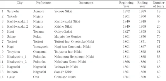
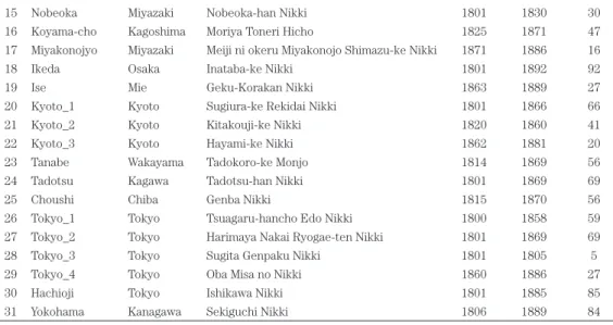
To reconstruct the typhoon history for the 19th century, we used a subset of the full HWD covering only that century. The subset of documents included data from 31 diaries based in 24 locations along the common typhoon tracks (Table 1 and Figure 1). We filtered these data to find entries only for the main months of the typhoon season (June through October). From 1951-2011, 170 (98%) of the 174 typhoons making landfall on the main islands of Japan did so between June and October (JMA 2012).
Table 1. Diaries covering the 19th century from the Historical Weather Database
City Prefecture Document Beginning
Year EndingYear Numberof Years
1 Sannohe Aomori Yorozu Nikki 1872 1889 18
2 Takada Niigata 1801 1866 66
3 Kashiwazaki_1 Niigata Kashiwazaki Nikki 1840 1848 9
4 Kashiwazaki_2 Niigata Kaisho Nikki 1849 1868 20
5 Himi Toyama Oukyo Zakki 1827 1858 32
6 Sabae Fukui Manabe-ke Monjyo 1801 1870 70
7 Tottori Tottori Tottori-han Ometsuke Nikki 1801 1871 71
8 Hagi Yamaguchi Hagi-han Ometsuke Nikki 1801 1867 67
9 Tsuyama Okayama Tsuyama-han Nikki 1801 1868 68
10 Kitakyushu_1 Fukuoka Nakamura Heizaemon Nikki 1811 1865 55
11 Kitakyushu_2 Fukuoka Nakahara Kazou Nikki 1868 1886 19
12 Nagasaki Nagasaki Isahaya-ke Nikki 1801 1868 68
13 Izuhara Nagasaki Sou-ke Nikki 1801 1869 69
15 Nobeoka Miyazaki Nobeoka-han Nikki 1801 1830 30
16 Koyama-cho Kagoshima Moriya Toneri Hicho 1825 1871 47
17 Miyakonojyo Miyazaki Meiji ni okeru Miyakonojo Shimazu-ke Nikki 1871 1886 16
18 Ikeda Osaka Inataba-ke Nikki 1801 1892 92
19 Ise Mie Geku-Korakan Nikki 1863 1889 27
20 Kyoto_1 Kyoto Sugiura-ke Rekidai Nikki 1801 1866 66
21 Kyoto_2 Kyoto Kitakouji-ke Nikki 1820 1860 41
22 Kyoto_3 Kyoto Hayami-ke Nikki 1862 1881 20
23 Tanabe Wakayama Tadokoro-ke Monjo 1814 1869 56
24 Tadotsu Kagawa Tadotsu-han Nikki 1801 1869 69
25 Choushi Chiba Genba Nikki 1815 1870 56
26 Tokyo_1 Tokyo Tsuagaru-hancho Edo Nikki 1800 1858 59
27 Tokyo_2 Tokyo Harimaya Nakai Ryogae-ten Nikki 1801 1869 69
28 Tokyo_3 Tokyo Sugita Genpaku Nikki 1801 1805 5
29 Tokyo_4 Tokyo Oba Misa no Nikki 1860 1886 27
30 Hachioji Tokyo Ishikawa Nikki 1801 1885 85
31 Yokohama Kanagawa Sekiguchi Nikki 1806 1889 84
(Source: Yoshimura 1993)
Figure 1: Locations of the Historical Weather Database documents used in this research on the 19th century (Source: Authors)
Next, we extracted entries with codes for strong wind, wind, heavy rain, rain and comments mentioning typhoons. The resulting data set included 13,326 records covering 92 years (1801-1892). To better capture likely typhoons, we then filtered the HWD data for records coded with “T” for typhoon and for strong wind and heavy rain resulting in a list of possible typhoons. We used entries for these weather conditions as they best capture the weather conditions associated with a typhoon and fit the meanings implied by the terms boufu¯ 暴風 (strong wind), boufu¯-u 暴風雨 or daifu¯-u 大風雨 (strong wind
and rain), and daifu¯ or o¯kaze 大風 (strong wind) in many historical descriptions (e.g. Kusakabe 1959; Kusakabe 1973; Central and Marine Observatory 1976). We combined the results into a list of potential typhoons that could be checked against other historical sources.
Grossman and Zaiki (2009) used this process to reconstruct an annual chronology of typhoons affecting Japan in the 1880s. A search of the HWD yielded 35 likely typhoons of which 26 could be found in other historical compilations as discussed in Sections 2 and 3 below. In addition to searching the HWD to compile a list of potential typhoons, the other historical sources were examined for events which did not appear in the HWD. We then went back to the HWD to check the weather for the dates of any typhoons found in other sources. In some cases, the information in the HWD was not sufficient to identify a typhoon on its own but it could still provide supporting data for a typhoon identified in another sources. Eight new events were found in the additional sources and corroborated with evens with typhoon characteristics in the HWD.
The 43 typhoons were then checked against monographs published by the Zi-Ka-Wei Observatory in China (Dechevrens 1881; 1882; 1884) and systematic instrumental data and weather maps published by the Imperial Meteorological Observatory (1883-1889) (discussed below in Sections 3 and 4). Corroboration from these additional sources could be found for 39 of 43 typhoons identified in the HWD. These results suggest that the HWD is a reliable source of data for identifying historical typhoons. The process of checking and cross-checking across multiple sources makes it possible to develop levels of confidence that a typhoon event has been correctly identified depending on the amount and type of evidence available.
2. Historical compilations from Japan
In addition to the HWD, we used data from two Japanese historical weather compilations. The first, Historical Records of the Climate of Japan 日本の気象史 料 (Central and Marine Observatory 1976), is a three volume compilation of climate
descriptions extracted from historical documents. Volumes Two and Three include information about typhoons from 473 to 1887 and a list of sources. Typhoon entries include historical sources, dates, locations, effects, damage, injuries and fatalities and, in the later 19th century, Japan Imperial Meteorological Observatory weather maps. Some entries rely on one source while others drew from multiple sources. In our research, we consider each individual report from a unique source to be one source. This source lists 255 events under boufu¯-u for the period 1801-1887. Many events have multiple sources. The second compilation was published as a series of articles on disasters throughout the prefectures of Japan in the Journal of Meteorological Research by Kusakabe. For our research, we have used “A Chronological Aspect of the Natural Disasters in Kyushu and Yamaguchi Prefecture” (Kusakabe 1959) and “A Chronological Aspect of the Natural Disasters in the Kanto District” (Kusakabe 1973). Kusakabe used official mid-20th century government collections which had been compiled from the original reports of the disasters in historical government and private documents. The compilations list
a wide variety of disasters including: earthquakes, strong winds and rains, typhoons, long periods of rain, thunderstorms, tornadoes, hail, floods, droughts, and heavy snows. Entries include the location, the date, the type of disaster and some explanation such as more specific location, amount and type of damage and fatalities. As in the HWD,
boufu¯-u was used for what is now referred to as a typhoon. For Kyushu and Yamaguchi
Prefectures, the earliest boufu¯-u reported was in the year 775. For the 19th century, 51 events were recorded. For the Kanto District, reports of boufu¯-u also go back as far as the 8th century but the record is richest for the 17th - 19th centuries with 87 events reported for the 19th century.
As with Historical Records volumes, we considered each report from a different source to be one independent source. In some cases, both compilations used the same source or a source such as the Catalog of Typhoons 1348-1934 (Selga 1935), one of the main sources for García-Herrera et al.’s (n.d.) online database. In such cases, each report was counted only once.
Compilations represent secondary or tertiary sources and while most reports based on official government documents are likely to be reliable, they are less so than primary sources. Further, as discussed earlier, there is no clear definition of a typhoon as we have in modern times. Still, typhoons coming close enough to Japan to bring strong winds and heavy rain are highly likely to be reported as they are major weather events. There may be some borderline cases that would not be officially considered typhoons today but it is likely that few important events would be missed completely.
We examined these compilations for the dates of events originally found in the HWD and then looked for additional events not in the HWD. We re-examined the HWD for any dates mentioned in the Historical Records volumes or Kusakabe’s articles for indications of weather such strong winds, winds, heavy rain and rain suggesting a possible typhoon that could be checked in other sources.
As discussed in Section 1, this approach made it possible to find supporting evidence for typhoons found in the HWD and to find events not mentioned in the HWD. In general, we tried to have multiple sources for each event whenever possible.
3. Early weather observations from outside Japan
During the 19th century, weather observations and data were being collected in other parts of the Pacific Basin outside Japan. Jesuit missionaries in the Philippines and China collected information about natural phenomena including weather. Because typhoons are also a major hazard in these countries, typhoon landfalls and passages through shipping lanes were commonly recorded. Many Jesuit missionaries were also interested in investigating typhoons in general since little was known about them at the time.
Jesuits arrived in the Philippines in the 16th century. Their duties included both missionary work and natural science investigations (Ribera et al. 2008). They started the Manila Observatory and its network of meteorological stations in the second half of the 19th century and managed it until it became part of the Philippines National Weather Service after World War II. Miguel Selga was a Spanish Jesuit who became the
last Spanish director of the Manila Observatory (1926-1946). In 1935, he published a
Catalogue of Typhoons 1348-1934 (Selga 1935), which he describes as ‘...an abridged
enumeration of the storms and typhoons as described by old chroniclers or described by contemporary documents’ (Ribera et al. 2005). Selga’s data included observations and, in some cases, instrumental data for typhoons from a variety of sources, including records from the Manila Galleons, British ships (Piddington 1876), Jesuits in the Philippines, and Spanish archives (García-Herrera et al. 2008). Selga’s chronology contains a total of 524 reports about typhoons before the 20th century.
Using Selga’s chronology, García-Herrera et al. (n.d.) assembled and published online a database of typhoons around the Philippine Islands and the Western North Pacific basin from 1566-1900. Data included are: year, month and day(s) of occurrence; Summary and description (original text from the Selga chronology); Type of Source: historical, instrumental, unknown; Intensity: typhoon, storm or depression (based on the classification produced by Selga); and, in some cases, an image with the approximate trajectory of the typhoon by the authors.
Although mentions of typhoons from Spanish ships near Japan go back to 1596, there are few reports before the 1880s due to the lack of contact between Japan and other countries until the second half of the 19th century. Most of the Selga Chronology typhoon reports do not directly mention Japan but some of the typhoons from before the 1880s can be connected to Japan using the dates and tracks in other historical documents. An example of an entry mentioning Japan is the following from August 16-24, 1886: “A typhoon developed in the Pacific E and NE of Manila, recurved to NNE and crossed SW Japan.” This entry includes an image of the storm track as inferred by the authors and can be linked to reports in Japan.
Additional typhoon data from the Philippines can be found in “Typhoons of 1894”
Baguios ó Tifones de 1894 (Algué 1895) including instrumental data and maps for the
typhoons in the region in 1894. It also includes typhoon track maps for storms between 1879 and 1894. These maps show storms that reached Japan. Further, in 1904, the Philippine Weather Bureau (under the U.S. Department of Interior at the time) produced two reports which include maps and details about typhoons in the region. The first report called, “The Cyclones of the Far East” (Algué 1904a) was a special report mapping and classifying typhoons in the region between 1880 and 1902 including storms that recurved to Japan. The second report “The Climate of the Philippines” (Algué 1904b), includes climatological details and maps of typhoons in the region between 1800-1898 also showing storms that eventually reached Japan.
During the same time period, Jesuit missionaries in China were also collecting information about weather and typhoons. Although most of the information about Japan is limited to the later part of the century (after 1880), it is still useful for the period before the Japan Imperial/Central Meteorological Observatory began publishing weather data and maps (in 1883) and because it includes data from the earlier stages of a typhoon’s life cycle and track.
published monographs documenting typhoons in the Seas around China between 1880 and 1883 (Dechevrens 1881; 1882; 1884). These monographs include observations and instrumental data from more than 50 locations in China, the Philippines and Japan and special reports from ships in the region and maps of typhoon tracks in the region. For example, Dechevrens (1881) includes the following descriptions of a typhoon’s impact on Tokyo in 1880.
At Tokio (Yeddo) the public gardens were partly laid waste; almost all the trees suffered more or less, many were uprooted; Japanese houses were utterly destroyed; 27 people were killed and 37 seriously hurt (p. 17).
A French resident at Tokio wrote: “I never spend such a fearful night (3rd-4th October); it seemed as the coming of Doomsday. Tiles were flying about in every direction, the oldest trees bent like rushes before the terrible wind. (p. 17).” The same resident also commented, “Whole roofs were uplifted and blown to a great distance just like saucepan lids; at the Fine Arts School there is not a whole door or window left; three houses fell down not far from my residence (p. 17).”
A report on the “Ash Typhoon” of September 24-28, 1881 (Dechevrens 1882) followed the track of the storm from its formation near Luzon in the Philippines, along the coast of China, to northeast into the Sea of Japan. The report includes barometric pressures and wind strength and direction from a variety of latitudes including ships at sea and lighthouses in Japan making it possible not only to track the typhoon but to estimate is strength and compare it to modern typhoons.
In this report, a Shanghai Courier correspondent in Nagasaki wrote the following about the typhoon,
Tiles were flying almost indiscriminately, sheet iron roofs were flapping in all direction, buildings were blown in, roofs take off, fences flying right and left, flag poles falling, and people were pretty much scared. I felt unsafe myself in one house which swayed and rocked as though an earthquake were shaking it up generally (p. 149).
In addition to the Dechevrens’ documents, a monograph entitled, “The Bokhara Typhoon” based on a lecture given by the Jesuit Reverend S. Chevalier was published in 1892 detailing a typhoon in October of that year that originated near Luzon in the Philippines, affected the coast of China and Taiwan and finally made its way to Japan passing over western Kyushu into the Japan Sea. The typhoon caused the sinking of the Steamer “Bokhara” with the loss of about 125 lives. The report includes instrumental data and observations from land and from the logs of ships at sea during the typhoon. This is an important resource for reconstructing the strength and details of the storm including, track, winds, barometric pressures, and damage. All of these monographs
make it possible to analyze primary data collected during the storms and to read first-hand accounts of people’s experiences of the events.
Although only some of the typhoon observations and descriptions from outside Japan include data and descriptions for typhoons affecting the Japanese Islands, even the ones that lack detail still indicate storms that recurved in that direction. These sources also often include information from ships at sea in the area. Information from these sources can be used in combination with sources in Japan to map the tracks of the typhoons, estimate their intensity and verify their tropical origin. These sources also often include the names of ships, their routes and the dates they were in the area, information that can be used to help locate additional information from the original ship logs which may be available in Naval Archives such as those in Washington D.C. and London, England.
4. Newspapers published in Japan
On Thursday, the 29th ultimo (last month), this place (Yokohama) was visited with a very severe storm which on Friday grew into a perfect Aurricane (hurricane), the rain falling for many hours in torrents. (The Japan Herald, June 7, 1862)
Terrible was the typhoon of the 12 of October last, the one which visited us last night was more terrible still. (from the Hiogo News as reported in The Japan Weekly Mail, July 15, 1871)
Kobe was visited on the 21 inst. (this month) by one of the most severe gales which has visited this port from some time past. (from the Hiogo News as reported in The Japan Gazette, August 27, 1874)
These quotes are from newspaper accounts of typhoons that affected Japan in the 1860s and 1870s. Such accounts would often be accompanied by land or ship-based data such as wind strength and direction and barometric pressures and reports of damage and casualties.
One of the most important sources of information about typhoons affecting Japan in the 19th century is English language newspapers published in Japan. Foreign newspaper began to be published in the 1850s soon after the country was opened to trade and settlement in the aftermath of Admiral Perry’s visits. Early newspapers focused strongly on trade and shipping but also included local events from around the country. Of course, weather and disaster news including typhoon landfalls and ship disasters were important news events to be reported. The newspapers also included excerpts from ship logs, reports on voyages around Japan and internationally, and sometimes instrumental weather data collected on land or onboard ships. We focused on these English language newspapers as they had a strong emphasis on events that would impact trade and shipping and had better access to instrumental data being collected by foreign residents and ships.
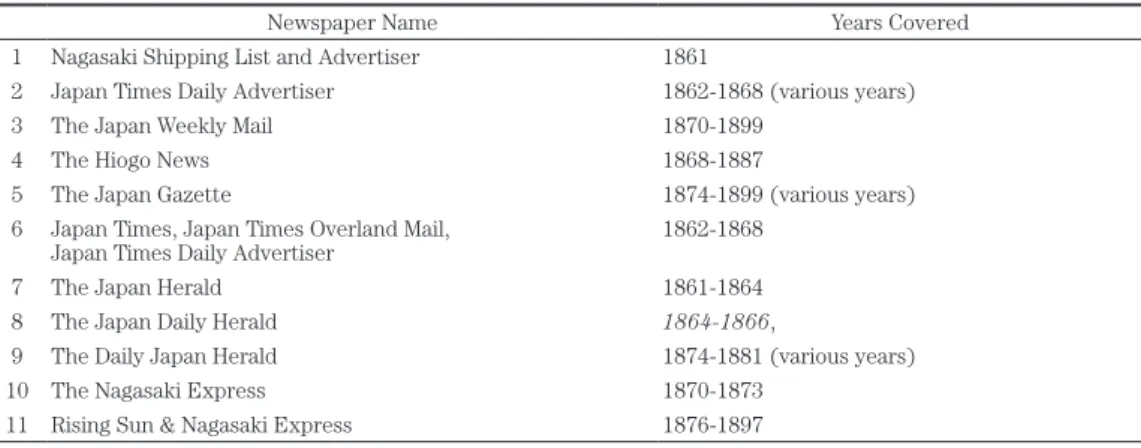
Listings of English language newspapers, their issue dates, and where they can be found are available in the catalog of Yokohama Archives of History 横浜開港資料館 and the Nihon Shoki Shinbun Zenshu¯ 日本初期新聞全集 . Hard copy of 19th century newspapers can be found at a number of locations in Japan. The most extensive and easily accessible collection is in the Yokohama Archives of History. The Archives hold various newspapers in Japanese and foreign languages, and magazines published in Yokohama since the late Edo period. In addition, newspaper archives could be found at the library of Tokyo Women’s Christian University and The Kobe City Archives (神戸市 文書館). Archives of the Rising Sun & Nagasaki Express are also available at Nagoya University and in archives in Nagasaki but we have not yet been able to examine them. Table 2 shows the newspapers available for the 19th century.
Table 2. English-language newspapers used in this research.
Newspaper Name Years Covered
1 Nagasaki Shipping List and Advertiser 1861
2 Japan Times Daily Advertiser 1862-1868 (various years)
3 The Japan Weekly Mail 1870-1899
4 The Hiogo News 1868-1887
5 The Japan Gazette 1874-1899 (various years)
6 Japan Times, Japan Times Overland Mail,
Japan Times Daily Advertiser 1862-1868
7 The Japan Herald 1861-1864
8 The Japan Daily Herald 1864-1866,
9 The Daily Japan Herald 1874-1881 (various years)
10 The Nagasaki Express 1870-1873
11 Rising Sun & Nagasaki Express 1876-1897
(Source: Authors)
For the newspapers we had access to, we carried out page by page searches for the months of the typhoon season for all available years looking for reports of typhoons and checking the dates of typhoons found in other sources. We found that the newspapers are a rich source of information about typhoons for the second part of the 19th century. They include:
① Short reports of disasters in the Summary of News (often on the front page) of typhoons affecting the islands and the damage they caused. For example, from the Japan Weekly Mail October 10, 1891, “A typhoon unprecedented in violence for fifty years was experienced in Oita Prefecture on the 14th of last month.” The report then gives a listing of damage to houses and infrastructure and number of injuries and fatalities.
② Longer news stories such as The Gale at Nagasaki (from The Rising Sun Source: Japan Weekly Mail Sept. 26, 1891) (Figure 2). “By far the severest and most protracted gale that has occurred her since September, 1881, was experienced on Sunday night and Monday morning last, causing
considerable damage both afloat and ashore.” The story goes on to describe the approach and passage of the storm with barometric pressure readings. Finally accounts of the damage onshore and offshore are given.
Figure 2: Except from a news story from The Rising Sun describing a typhoon affecting Nagasaki on September 16, 1891 (Source:
Japan Weekly Mail, Sept. 26, 1891)
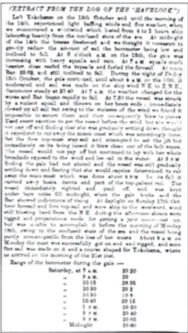
③ Reports from ships such as this report (Japan Weekly Mail, Sept. 26, 1891) from the Saikio Maru’s attempt to leave Nagasaki for Shanghai as a typhoon approached. The ship was forced to return to Nagasaki and wait out the typhoon in port. The story includes a description of the wind strength and direction and barometric pressures every half hour during the storm. The newspapers also sometimes include extracts from the actual ship logs such as the one in Figure 3 describing the Havelock’s encounter with a typhoon after leaving Yokohama.
Figure 3: Extract from a ship log describing the typhoon of October 15-16, 1869 (Source: Japan Times Overland Mail, October 28, 1869)
④ Because of their commercial and maritime focus, these newspapers often included a section detailing the arrivals and departures of ships in Japan sometimes including information about the weather during their voyage. Information such as the ships name, country, captain, ports, and sailing dates provide data that can be used to locate the original ship logs which usually include detailed information and instrumental data about the weather during a voyage.
Ship logbooks are an extremely valuable source of weather data for historical reconstructions. Mock et al. (2010) used ship logbooks to reconstruct the path, intensity and impacts of a hurricane making landfall near New Orleans, Louisiana, U.S.A. in 1812. Wheeler et al. (2009) used historical data including ships’ logbooks to reconstruct the track of a hurricane in August 1680 and Wheeler et al. (2010) used Royal Navy logbooks from 1685-1750 to examine atmospheric circulation and storminess in the English Channel. It is expected that our research on 19th century typhoons in Japan will be enhanced at the individual storm level through the use of ship logbooks.
5. Japan Meteorological Observatory records
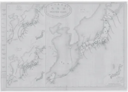
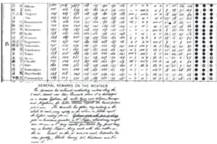
The last of our sources includes instrumental weather data (beginning in 1875) and daily weather maps (beginning in 1883) published by the Japan Imperial Meteorological Observatory (IMO) later called the Central Meteorological Observatory (CMO) of Japan and, in modern times, the Japan Meteorological Agency (JMA). The IMO was established in 1875 and began collecting instrumental data at locations in Japan. The IMO/CMO began to publish tridaily weather maps in August 1883 and the first national forecasts in 1884. These maps, showing pressure, wind speed and direction, overall conditions, and temperature, were issued at 0600, 1400, and 2100 (local time, +9 = UTC) each day (Figure 4). The maps also include a written description of the overall weather and any warnings that were issued. Accompanying the maps are instrumental data (including pressure, wind speed and direction, rainfall amounts, temperature, and overall weather) from 25-28 land-based stations throughout Japan and, later, from stations in Korea, China, and Russia (Figure 5). The maps and data are in Japanese and English. One major limitation of these maps is that they include only land-only observations. However, since our research is primarily concerned with typhoons affecting the four main islands, this limitation is not likely to impact our list.
Figure 4: Weather map for October 7, 1899-10 pm, 6 am and 2 pm showing a typhoon moving along the Pacific Coast of Japan (Source: Central Meteorological Observatory of Japan, 1899)
Figure 5: Sample data and remarks for October 7, 1899, the day of a typhoon (Source: Central Meteorological Observatory of Japan, 1899)
The IMO/CMO weather maps and data are critical for corroborating reports from other sources, verifying the reliability of the other sources, and for comparison with typhoon frequencies from earlier in the 19th century. We first used the IMO/CMO maps and data in a reconstruction of typhoons affecting Japan in the 1880s (Grossman and Zaiki 2009). In that study, we checked the IMO/CMO maps for the days of potential typhoons identified in the HWD and other historical compilations to verify the presence of a typhoon. We subsequently used the maps to corroborate reports of typhoons found in newspapers as well by cross-checking the dates.
An important challenge in using the IMO/CMO maps and data is the recurring problem of a standard definition of a typhoon and the use of term “typhoon.” The term “typhoon” is not used in the maps, data or descriptions until late in the 1880s. While other terms such as cyclone, cyclonic winds, and gale are used, it is still necessary to interpret the weather map, data and description to determine if the event is indeed a typhoon. It is necessary to examine wind speeds, changes in wind direction, heavy rain, pressure, and direction and speed of movement of the low pressure system.
In addition to using the IMO/CMO maps to verify reports from other sources, we plan to carry out a daily search of the months of the typhoon season to identify any storms that might not have appeared in other sources. We can then check the dates of these storms against other sources to verify the presence of a typhoon.
IV. Preliminary results
The first goal of this research is to reconstruct a list of typhoons that affected Japan in the 19th century based on the historical documents. We have so far developed a
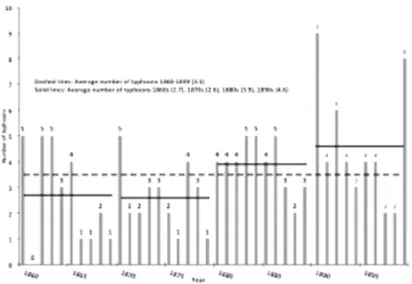
preliminary list for the 1860s through 1890s based on various combinations of historical sources (Figure 6). This list is considered preliminary because we have not yet analyzed and included all sources we have collected.
Figure 6: Annual number of typhoons affecting Japan 1860-1899 based on historical documents. This figure represents preliminary results from a combination of sources as discussed in the text (Source: Authors)
The average annual typhoon frequencies calculated from our list so far compare favorably to modern average annual frequencies. For the period 1951-2011, the annual frequency of typhoons coming within 300 km of the four main islands of Japan is 5.4 per year and for landfalls, it is 2.9 per year. From our list, the annual frequency for 1860-1899 is 3.5. Our result is close to but somewhat below the modern average which is reasonable as some of the storms affecting the islands may not have technically crossed over land but passed near enough to the coast to have an impact and be reported. The average frequency passing within 300 km in the modern record is somewhat higher than the historical average. This may be due to our definition of a typhoon being more liberal than the modern definition and/or to the historical list being mainly limited to reports from land or near land-based sources. In any case, our results are consistent with the modern frequencies in that they fall between the two modern frequencies and are neither much higher nor much lower.
Overall, however, if we assume that the historical list likely captures all or nearly all typhoons that affected Japan, our results suggest higher average annual typhoon frequencies in the second half of the 19th century compared to the modern record. Within the second half of the century, the results suggest that typhoons affected Japan more frequently in the period 1880-1899 (85 typhoons for an annual average of 4.25) than during the earlier period 1860-1879 (53 typhoons for an annual average of 2.65).
Further support for the accuracy of these results will depend on establishing climatic conditions that could have caused such variability. In addition, comparison of these results with similar historical lists from China (Elsner and Liu 2003) and the Philippines would lend support to our results and conclusions.
V. Concluding remarks
As part of our first goal of reconstructing a list of typhoons that affected Japan in the 19th century based on historical documents, we plan to extend what we have done so far and use all the sources available in each decade to complete the reconstruction for the full century. This will make possible more complete interdecadal and longer-term comparisons. The 19th century record can then be integrated into and compared to similar-scale typhoon reconstructions from China (e.g., Chan and Shi 2000; Liu et al. 2001; Fogerty et al. 2006) and the Philippines (García-Herrera et al. 2007b) to better understand the regional distribution of typhoon frequencies. Combining data from many countries in the region will also make it possible to map historical typhoon tracks for the entire region to better understand the variability of typhoon behaviors over longer time periods under climatic conditions differing from those of the late 20th and early 21st centuries.
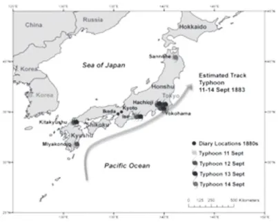
The second stage of our planned analysis is to use the information about historical typhoon tracks around Japan with Geographical Information Systems software such as ArcGIS (ESRI 2013) to map and classify the typhoon tracks. For example, we used the locations of reports from the HWD to estimate the tracks of a typhoon between September 11-14, 1883 (Figure 7). The mapped typhoon locations and tracks can then be compared with modern typhoon locations and tracks and synoptic weather maps to reconstruct atmospheric conditions (e.g. pressure patterns, wind speed and direction, precipitation) associated with the historical typhoons. The reconstructed history of typhoons and maps of their tracks can also be used examine links between typhoon frequencies and behavior and reconstructions of 19th atmospheric-oceanic phenomena such as El Niño Southern Oscillation and Pacific Decadal Oscillation (e.g. Elsner and Liu 2003).
Figure 7: The track of the typhoon of Sept. 11-14, 1883 based on reports in the Historical Weather Database (Source: Authors)
The third stage of this research is to reconstruct in greater detail some of the major typhoons of the 19th century and attempt to compile a list of the most intense and destructive typhoons of that century. Ribera et al. (2008) reconstructed such a list for the Philippines and Mock (2008) developed a similar list for Louisiana, USA. Mock et al. (2010) also described in detail a hurricane that affected New Orleans, Louisiana, U.S.A. in 1812 and compared it to a similar storm in the 20th century. Wheeler et al. (2009) used historical data including ships’ logbooks to reconstruct the track of a hurricane in August 1680. Some of the storms we have identified have been reported in numerous sources with extensive details about winds speeds and directions, tracks, rainfall and damage. In cases where references to ships logs are made, we plan to use the logs to add details to storm descriptions.
This research provides support for the importance of historical climatology and the use of historical documents to reconstruct past climates. The typhoon history and details reconstructed by this research will provide a basis for a better understanding and prediction of typhoon behavior in the Western North Pacific Basin. The extended record will make it possible to test present models and develop new models of typhoon behavior under varied climate conditions which differ from those of the period of systematic instrumental records (the post-1951 period). Our data can also be used in models of typhoon behavior for prediction, insurance estimation, and mitigation strategies based on probabilities of typhoon landfalls and tracks over the long term. This is especially important in light of concerns about the impacts of global warming and the need for preparedness planning and potential increased expenditures for typhoon damage mitigation.
References
Algué, José 1895. Baguios o Tifones de 1894 (Typhoons of 1894), Manila: Partier (in Spanish).
_____ 1904a. The Cyclones of the Far East. Manila: Bureau of Public Printing.
_____ 1904b. The Climate of the Philippines. Department of Commerce and Labor, Bureau of the Census.
Blake, E. S., C. W. Landsea, and E. J. Gibney 2011. The Deadliest, Costliest, and Most
Intense United States Tropical Cyclones from 1851 to 2010, NOAA Technical
Memorandum NWS NHC-6, August 2011,
www.nhc.noaa.gov/pdf/nws-nhc-6.pdf, retrieved 31 Aug. 2013.
Bossak, B. H. and J. B. Elsner. 2004. “Plotting Early Nineteenth-Century Hurricane Information”, EOS, Transactions of the American Geophysical Union, 85(20), p.199.
Brázdil, R., C. Pfister, H. Wanner, H. von Storch, and J. Luterbacher. 2005. “Historical Climatology in Europe: the State of the Art”, Climatic Change, 70(3), pp.363-430. Central and Marine Observatory 1976. Historical Records of the Climate of Japan (日本
の気象史料), Volume 1, Tokyo: Hara Shobou (in Japanese).
Chan, J. C. L., and J. Shi 2000. “Frequency of Typhoon Landfall over Guangdong Province of China during the Period 1470-1931”, International Journal of Climatology, 20, pp.183-190.
Chevalier, S. 1893. The “Bokhara” Typhoon, October 1892: Read Before the Shanghai
Meteorological Society, “North-China Herald” Office.
Dechevrens M. 1881. The Typhoons of the Chinese Seas in the Year 1880, Shanghai, China: Kelly and Walsh.
_____ 1882. The Typhoons of the Chinese Seas in the Year 1881, Shanghai, China: Kelly and Walsh.
_____ 1884. Les typhons de 1882 première partie: Les typhons des mois de Juillet
et Aout (The Typhoons of 1882 Part I: Typhoons of July and August, Shanghai,
China: Kelly and Walsh (in French).
Elsner, J. B., and K. Liu. 2003. “Examining the ENSO-typhoon Hypothesis”, Climate
Research, 25, pp.43-54.
Emanuel, K. A. 2005. “Increasing Destructiveness of Tropical Cyclones over the Past 30 Years”, Nature, 326, pp.686-688.
Fogarty, E. A., J. B. Elsner, T. H. Jagger, K. Liu, and K. Louie, 2006. “Variations in Typhoon Landfalls over China”, Advances in Atmospheric Sciences, 23(5), pp.665-677.
García-Herrera, R., F. R. Duran, D. Wheeler, E. Hernandez, M. R. Prieto, and L. Gemeno, 2004. “The Use of Spanish and British Documentary Sources in the Investigation of Atlantic Hurricane Incidence”, in R. Murnane and K. B. Liu (eds.), Hurricanes and
Typhoons: Past, Present, and Future, New York: Columbia University Press,
pp.149-176.
from Spanish Documentary Sources”, Journal of Geophysical Research, 110: D03109; DOI:10.1029/2004JD005272.
_____, L. Gimeno, P. Ribera, E. Hernández, E. González, and G. Fernández, 2007a. “Identification of Caribbean Basin Hurricanes from Spanish Documentary Sources”,
Climatic Change, DOI: 10.1007/ s10584-006-9124-4.
_____, P. Ribera, E. Hernández, and L. Gimeno, 2007b. “Northwest Pacific Typhoons Documented by the Philippine Jesuits, 1566-1900”, Journal of Geophysical
Research, 112, D06108, doi:10.1029/2006JD007370.
_____, P. Ribera, E. Hernández and L. Gimeno. n.d. The Selga Chronology Part I:
1348-1900, www.ucm.es/info/tropical/selga-i.html, accessed August 2013.
Grossman, M. and M. Zaiki, 2007. “Reconstructing Typhoon Landfalls in Japan from Historical Documentary Records 1801-1830”, in L. M. B. Harrington and J. A. Harrington, Jr. (eds.), Papers of the Applied Geography Conferences October
17-20, 2007, 30, pp.334-343.
_____ and M. Zaiki, 2008. “Reconstructing Typhoon Landfalls in Japan in the 19th Century using GIS”, in L. M. B. Harrington and J. A. Harrington, Jr. (eds.), Papers of the
Applied Geography Conferences October 15-18, 2008, 31, pp.152-161.
_____ and M. Zaiki, 2009. “Reconstructing Typhoons in Japan in the 1880s from Documentary Records”, Weather, 64, pp.315-322.
Imperial (Central) Meteorological Observatory, 1883-1899. Tridaily Weather Maps:
Reports, Remarks and Indications, Tokio (Tokyo), Japan.
Japan Meteorological Agency (JMA), 2012. Number of Typhoons Making Landfall
on the Japan Main Islands (Honshu, Hokkaido, Kyushu, Shikoku). Japan
Meteorological Agency,
http://www.data.jma.go.jp/fcd/yoho/typhoon/statistics/landing/landing.html, accessed August 2012.
_____ 2013. Normal Values for Typhoons 1981-2010,
www.data.jma.go.jp/fcd/yoho/typhoon/statistics/average/average.html, accessed 29 Sept. 2013.
Kitamoto A. 2008. “Digital Typhoon: Typhoon Disaster Database”, agora.ex.nii.ac.jp/digital typhoon/disaster/damage/, accessed August, 2008.
Knutson, T. 2013. Global Warming and Hurricanes. Geophysical Fluid Dynamics
Laboratory/NOAA, published online:
www.gfdl.noaa.gov/global-warming-and-hurricanes, Sept. 3, 2008; last revised January 30, 2013, accessed August, 2013.
Kusakabe, M. 1959. “A Chronological Aspect of Natural Disasters in Kyushu and Yamaguchi Prefectures”, Journal of Meteorological Research, 11, pp.423-465 (in Japanese).
_____ 1973. “A Chronological Aspect of the Natural Disasters in the Kanto District”,
Journal of Meteorological Research, 5, pp.383-403, 429-447 (in Japanese).
Liu, K., C. Shen, and K. Louie, 2001. “A 1000-year History of Typhoon Landfalls in Guangdong, Southern China Reconstructed from Chinese Historical Documentary
Records”, Annals of the Association of American Geographers, 91, pp.453-464. Louie, K. and K. Liu, 2004. “Ancient Records of Typhoons in Chinese Historical
Documents”, in R. Murnane and K. B. Liu (eds.), Hurricanes and Typhoons: Past,
Present, and Future, New York: Columbia University Press, pp.222-248.
Maejima I. and Y. Tagami. 1986. “Climatic Change during Historical Times in Japan: Reconstruction from Climatic Hazard Records”, Geographical Reports of Tokyo
Metropolitan University, 21, pp.157-171.
Mikami T. 1992. “Climate Variations in Japan during the Little Ice Age: Summer Temperature Reconstructions since 1771”, in T. Mikami (ed.), Proceedings of the
International Symposium on the Little Ice Age Climate, Tokyo: Tokyo Metropolitan
University, pp.176-181.
_____ 1996. “Long Term Variations of Summer Temperatures in Tokyo since 1721”,
Geographical Reports of Tokyo Metropolitan University, 31, pp.157-165.
Ministry of Land, Infrastructure and Transport, 2004. “White Paper on Land, Infrastructure and Transport in Japan”,
www.mlit.go.jp/english/white-paper/mlit04.html, accessed 15 Sept. 2005.
Mock, C. J. 2004. “Tropical Cyclone Reconstructions from Documentary Records: Examples for South Carolina, U.S.”, in R. Murnane and K.B. Liu (eds.), Hurricanes
and Typhoons: Past, Present, and Future, New York: Columbia University Press,
pp.121-148.
_____ 2008. “Tropical Cyclone Variations in Louisiana, U.S.A. since the Late Eighteenth Century”, Geochemistry, Geophysics, and Geosystems, 9, Q05V02, doi:10.1029/2007GC001846.
_____, M. Chenoweth, I. Altamirano, M. D. Rodgers, and R. García-Herrera, 2010. “The Great New Orleans Hurricane of 1812”, Bulletin of the American Meteorological
Society, 91, pp.1653-1663.
Park, D.-S. R., C.-H. Ho, J.-H. Kim, and H.-S. Kim, 2011. “Strong Landfall Typhoons in Korea and Japan in a Recent Decade”, Journal of Geophysical Research, 116, D07105, doi:10.1029/2010JD014801
(http://dx.doi.org/10.1029/2010JD014801).
Piddington H. 1876. The Sailors Handbook for the Law of Storms, London: Smith, Elder and Co.
Pielke, R. A., C. Landsea, M. Mayfield, J. Laver, and R. Pasch, 2005. “Hurricanes and Global Warming”, Bulletin of the American Meteorological Society, 86, pp.1571-1575.
Rappaport E. N., J. Fernandez-Partagas, 1995. The Deadliest Atlantic Tropical
Cyclones, 1492-1996, NOAA Tech. Memorandum NWS NHC 47 updated 22 April 1997
by Jack Beven http://www.nhc.noaa.gov/pastdeadly.shtml. accessed May 27, 2007. Ribera P., R. García-Herrera, E. Hernández and L. Gimeno, 2005. “Typhoons in the
Philippine Islands, 1901-1934”, Climate Research, 29, pp.85-90.
_____ and L. Gimeno, 2008. “Historical Deadly Typhoons in the Philippines”, Weather, 63(7), pp.194-199, doi:10.1002/wea., 275.
Selga M. 1935. “Charts of Remarkable Typhoons in the Philippines 1902-1934”, Catalog of
Typhoons 1348-1934, Manila: Manila Weather Bureau, 55 pp.
Stowasser M., Y. Wang, and K. Hamilton, 2007. “Tropical Cyclone Changes in the Western North Pacific in a Global Warming Scenario” Journal of Climate, 20, pp.2378-2396. Wang, R., L. Wu and C. Wang, 2011. “Typhoon Track Changes Associated with Global
Warming”, Journal of Climate, 24, pp.3748-3752, doi:10.1175/JCLI-D-11-00074.1. Webster, P. J., G. J. Holland, J. A. Curry and H. Chang, 2005. “Changes in Tropical Cyclone
Number, Duration, and Intensity in a Warming Environment”, Science, 309(5742), p.1844.
Wheeler, D., R. Garcia-Herrera, C. W. Wilkinson and C. Ward, 2010. “Atmospheric Circulation and Storminess Derived from Royal Navy Logbooks: 1685-1750”. Climatic
Change, 103: 10.1007/s10584.009.9755.3.
_____, J. M. Vaquero, R. García-Herrera, M. Chenoweth and C. J. Mock, 2009. “Reconstruction of August 1680 Hurricane Trajectory: the Earliest Documented Extratropical Transition?”, Bulletin of the American Meteorological Society, 90, pp.971-978.
Wu, L., B. Wang and S. Geng, 2005. “Growing Typhoon Influence on East Asia”,
Geophysical Research Letters, 32, p.18.
Yoshimura, M. 1993. “Historical Weather Database and Reconstruction of the Climate in Historical Time”, Journal of Geography, 102 (2), pp.131-143 (in Japanese).