The Geology of Kagawa and Northern Ehime Prefectures,
Shikoku, Japan
Minoru
SAITO
List of Contents Page Abstract 1 Introduction 2 Acknowledgements 3I Historical Review of the Works on the Geology and Paleontology of the Setouchi Area 3
IT.
Geology of the Inner Zone of Shikoku 12A -Sambagawa Metamorphics 12 B -Yamaguchi Group 14 C -Ryoke Metamorphics 14 D -GI anite 15 E -1zumi Group 17 F -Kuma Group 19 G -Tonosh0 Group 20 H-Sanuki Group 21 I -1shizuchi Group 23
J -The Lacustrine Deposits 24
K-Yakeotoge Gravels 36
L -Ter r ace and Fan Deposits 37
a.
Igneous Activity 38IV. Geological Structures 40
A-Unconf or mities 40 B -Faults 42 C -Median Line
44
D
-Folding 45 E-Basin Structure 46 V.
Sedimentary Structures 46VI. Geological Ages of the Formations 5 1
W Boundary between the Pliocene and Pleistocene Deposits in Kagawa and Ehime Prefectures 56
m.
Correlation 58M
Geological History 61Bibliography 67
Explanation to Plates
Abstract
More than ten years field and laboratory work on the geology and paleontology of the deposits ranging from Cretaceous to Pleistocene distributed in Kagawa and northern Ehime Prefectures has resulted i n the distinction of lacustrine deposits of Pliocene age, the establishments of stratigraphic units, recognition of geological structures hitherto left unnoticed, concrete evidence for the number of activities of the Median Line and others
The previously considered Quaternary deposits are shown to belong to the Pliocene and to represent lacustrine deposits. These lacustrine deposits have extensive distribution throughout Ehime and Kagawa Prefectures and continue farther eastwards to Nara, Mie and Aichi Prefectures and are characterized everywhere by the yield of Metasequoia-Stegodon assemblage.
Throughout northern Shikoku deposits of Miocene marine sediments are missing except in small patches in the island of ShBdo-shima, whereas those of the Paleogene are represented by the Kuma group of Eocene age T h i s shows that the period of denudation was a long and varied one, ranging from Oligocene throughout the Miocene in northern Shikoku aside from ShBdo-shima
2
M. Saito
Similary the restricted distribution of marine Pleistocene deposits i n t h e Setouchi area also shows that the conditions were varied during the late Pliocene to Pleistocene ages I t i s shown that the marine Pleistocene invasion into the Setouchi area was contemporaneous with the intense crustal movement during the post-Pliocene pre-Pleistocene break
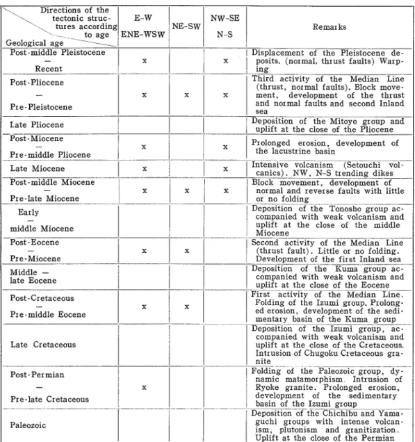
The long debated problem of number of time of activity of the Median Line i s now proved by field evidence have taken place a t least three time, namely, during the post-Cretaceous pre-Kuma, post- Kuma pre-Ishizuchi, and post
-
lacustr ine deposits and pre-Yakeotoge gravelsAlthough i t may be problem that other ages of the movements may be discovered, at least in n o r t h e ~ n Shikoku, i t is deemed that the stated three movements are well established. From sedimentary structure preserved in the Cretaceous Izumi group and i n the Pliocene lacustrine deposits, it i s shown that deposition was rapid i n the rapidly downsinking through of the Izumi sea in which turbidities are well developed and have dist~ibution, showing there many interesting structures However, in the lacustrine deposits where sedimentary structure also well preserved, the inferred conditions are quite different from that of the Izumi group because deposition was in a linear basin, shallow, now preserved only in the depressed areas, in that major structure a r e not developed Another characteristics of the lacustrine sedimentary structures is the development of local features However, i t is noticeable that the local structures reflect the sedimentary environment of the different part of the extensive paleo-Setouchi Lake
Aside from the geological structure which is given in detail considerable details are given to t h e correlation of the Pliocene and Pleistocene deposits in the Setouchi area a s well as also with adjacent areas From this correlation table i t i s evident that t h e climatic conditions were varied from cold to moderate or warm and i t is well reflected in t h e flora, fauna and also in t h e kinds of sediments distributed in the different parts of t h e Pleistocene deposits
Introduction
The present work which commenced more than ten years ago concentrates on the geo-
logy of the rocks ranging pre-Cretaceous, Cretaceous up to and through the Pleistocene
distributed in the northern part of Ehime Prefecture and Kagawa Prefecture. This par-
ticular area was selected for several reasons, such as, the hitherto accepted deposits ex-
tensively distributed in the two Prefectures actually comprise sediments of the Pliocene
and of the Pleistocene, the number of time of activity of the Median Line had been
interpreted variously and the field evidence had been obscure in many cases, and the
sequence of the different deposits (volcanic and sedimentary) had been clear.
Also the geological structures of the deposits ranging from Cretaceous to Pleistocene
had been left almost untouched. For such reasons as well a s for others, the writer
studied the area in detail and for the purpose several provinces were distinguished for
the sake of brevity. Since rocks of pre-Cretaceous age are not well distributed in the
studied area and because they are better developed in other areas, details concerning
them have not been included into the present work.
The chief purpose of the present study i s to clarify the sedimentary environment of
the lacustrine deposits of Pliocene age, to settle the boundary between the Pliocene and
Pleistocene deposits to find their relationship within the Setouchi areas a s well a s in
the adjacent ones. For the study mechanical analysis of many samples from different
stratigraphic levels and geographic positions were undertaken, detail stratigraphic
columns were whereas possible, sedimentary structures were recorded in detail and their
occurrences plotted, data from drilled wells a s well a s those dug for irrigation purposes
were also included into the study, and paleontological evidence was incoporated.
By field and laboratory works just outlined, this work was brought to i t s present
condition and although i t is felt that more evidence is necessary i t also i s considered
that our knowledge to date should be into a published to advance our knowledge on the
geology of Shikoku and also of Japan
The Geolog,y gf' Kagawa and Nortlzern Ehime Prefectures
3
Acknowledgements
The writer wishes to express his thanks to Professor Kotora HATAI of the Institute of
Geology and Paleontology, Tohoku University, for his kind guidance in the field and in
the laboratory
.
The writer, who wzs first introduced to the study of geology by Dr. Shbshiro HANZAWA,
Professor Emeritus of the Tohoku University, takes this opportunity to express his deep
gratitude to him for his continued encouragement.
Sincere thanks a r e expressed to Prfessors Enzb KONNO
and Kiyoshi ASANO, both of the
Institute of Geology and Paleontology, Faculty of Science, Tohoku University for their
encouragements.
He deeply appreciates the kindness of Professor Tadao MAEKAWA,
Dean of the Faculty
of Agriculture of the Kagawa University who made possible the writer's research during
1960 to 1961 in the Institute of Geology and Paleontology, Tohoku University.
During the course of the present work the writer has received valuable support from
the following persons to whom he tskes this opportunity to express his deep gratitude,
Dr.
Hisakatsu YABE, Professor E ~ n e r i t u s
of the Tohoku University and P~ofessor Motoki
EGUCHI
of the Faculty of Technology of the Tohoku University for their encouragements
in various way; Dr. Shigeru MIKI, Professor of the Bsaka City University and Dr. Keiji
SUZUKI
of the Fukushima University for their valuable suggestions concerning the plant
fossils; Professor Koz6 NAGAI of the Ehime University for his permission to study his
data and Dr. Kankichi SOHMA
of the Tohoku University for his pollen analysis of peaty
matter and Dr. Taiji KUROKAMI
for his encouragement in various way.
Acknowledgements a r e also due to the following persons for their help i n many ways;
Dr. Tamio KOTAKA, Dr. Shozb HAYASAKA,
Dr. Koichiro MASUDA, Dr. Shin KITAMURA,
Dr. Masafumi MURATA, and the members of the Institute of Geology and Paleontology,
Tohoku University; Professor Wataru ISHIJIMA
of the Rikkyo University; Dr. Rikii SHOJI
of the Tohoku University; Dr. Yoshio ARAKI and M r . Jun YAMADA, both of the Mie
University; Dr
Jiro KATTO and Dr. Jun NAKAMURA,
both of the Kochi University;
Dr. Jun AKUTSU
of the Utsunomiya University; Mr. Shigeichi YAGI of the Matsuyama
Museum; Mr. Katsuaki HIYAMA
of the B o ~ r d
of Education of Ehime Prefecture; M r .
Kazu TAKAHASHI
of the Mizukue Middle School, Ehime Prefecture; Mr Shoichi KONDO
of t h e Kaneko Primary School, Niihama City; Mr. Yuji BANDO
of the Faculty of Liberal
Arts and Education of the Kagawa University
;Dr Masaki UEHARA, DI . Hachiro KIRA,
Mr Hiroo INOUE,
Mr. Kazuyoshi NAKAYAMA,
Mr. Yutaka UMEDA, Mr. Takeshi WAKIYA,
and the members of the Faculty of Agriculture, Kagawa University.
For Photographic work of M r . Kimiji KUMAGAI
of the Tohoku University, the writer's
thanks a r e also expressed.
Thanks are also due to the Ministry of Education, for financial support from the Sci-
ence Expeditur e Fund,
I
.
Historical Review of the Works on the Geology and Paleontology
of the Setouchi Area
In 1894, K . WAKABAYASHI
wrote on the discovery of mammalian fossils from the
vicinity of Shaganohana in Sh6do-shima, but gave neither generic or specific names.
U.
OGAMI (1895) reported that Mt. Iyatani i n the Sanuki district consists of conglo-
merate, but made no mention as to its age.
T . SUZUKI (1896) i n his explanatory text to the geological map of Tokushima i n the
scale of 1:200,000; wrote that the pyroclastic group bearing sanukite (including the coal
4
M .
Saito
bearing strata) belong to Pliocene in age.
E.
SAKAWA
(1898) reported that Mt. Iino in Sanuki province is independent of the
older volcano.
M. YAMAGAMI
(1898) made a geological map of the Marugame area in the scale of
1
:200,000; but did not distinguish the different rocks from one another.
D. SATO (1900) in his survey of the sanukite in the vicinity of Sanno, Sakaide City,
stated that there are diabase xenoliths in the sanukitic rocks.
T . OGAWA (1898, 1902, 1907) found a kind of conglomerate developed in the small
valley of Ichinokawa in Iyo province and called i t "Ichinokawa conglomerate". He thought
that i t is a relic of a Cretaceous valley cut through the crystalline schist and so he
regarded the Izumi sandstone as sediments deposited in a more or less narrow, shallow
inland sea.
S . NODA and Y . Kozu (1910) in their explanatory text to the geological map of the
Matsuyama, wlote on the general geology and geomorphology of Matsuyama district.
H. YABE (1915) from the paleontological basis, inferred that the marine Cretaceous
rocks well developed along the northern and southern sides of the island of Shikoku and
the adjacent parts of Honshu and Kyushu were deposited in an open sea and he
maintained that a t least, there is no data favourable for the opposite assumption by
NAUMANN,
HARADA
and OGAWA.
B. KOTO (1916) made a petrographical study of the sanukite distributed in the
Kokubudai district and classified i t into two types, sanukite proper and bronzite andesite.
H.
MATSUMOTO
(1916) reported on the occurrence of Stegodon orientalzs, Stegodon
sznensis, Elephas namadzcus, Bzson sp. and Cervus sp. from the sea-bottom near ShBdo-
shima
.
T . OGAWA (1919, 1920) wrote on the Tertiary deposits of the Ise district and called
the younger Tertiaty sediments the AgC coal-bearing formation.
J.
MAKIYAMA
(1924) described Elephas trogontheriz PHOLIG
dredged from the bottom
of the Inland Sea off Shirahama, ShGdo-shima, Sanuki province. At the same time, he
listed 18 named species of Mollusca from the Maiko shell bed near Kobe, and described
some important species and stated that the age of this fauna i s not younger than that of
the upper Musashino series.
M. MORISHITA
(1921, 1929) stated that the Ishizuchi-yama Tertiary system is dis-
tributed in the Inner Zone in the vicinity of Takahama, Matsuyama City, and reported
on the relation between this system and the Median Line.
H. MATSUMOTO
(1924, 1929) described Loxodonta namadzca naumanni (MAKIYAMA)
and
Loxodonta namadzca namadz were dredged from the Inland Sea, and stated that its age
belongs to the mid-Pleistocene.
In 1926, Y. OZAWA
in his paper on the primitive elephants from the Setonaikai area
and on the sanukite bearing pyroclastic rocks included the Yashima gravel into his namely
proposed Setouchi group.
The age, according to
H.
MATSUMOTO
(1924) and
J.
MAKIYAMA
(1924) from their
studies on the mammalian fossils from the Inland Sea, is stated by OZAWA
to be middle
to lower Pleistocene.
S. NAKAMURA
(1926) stated that the all of the lake deposits distributed in Nara,
Yamashiro, Kyoto and Osaka are older Plesitocene in age.
S . YEHARA (1926) reported on the stratigraphy of the Izumi group in the eastern part
of the Sanuki mountain range and cited the stratigraphical sequence as follows, from the
lower,
(1) Basal conglomerate (2) Hiketa shale
(3)
Fucoid sandstone(4)
Hashikura shale.T h e Geo1og.y o f Kagawa and Northern Ehime Prefectures
5
scale of 1
:75,000,
wrote that the young sediments distributed in Namigata and Obie,
Okayama Pr efectur e , belong to the Tertiary System, because the sediments correspond
to the Miocene strata developed in the Shobara district, Hiroshima Prefecture, on the
basis of the lithological similarity and the distribution.
H. SATO (1929) surveyed the Kuma district, Ehime Prefecture and described the
geological sequence as follows in ascending order, pre -Carbonif erous
, upper Paleozoic,
upper Cretaceous (Izumi group) , Miocene (Ishizuchiyama group), Pleistocene.
T. OSE (1929) in his study of the sediments of the Chita Peninsula in Aichi Prefec-
ture, discovered lake deposits which he called the Tokoname formation and stated that i t
belongs questionably to the Pleistocene.
M. SATO (1929) wrote on the discovery of a graphite-schist pebble in the gravel bed
a t Goshikihama of Awaji Island and discussed the origin.
K. KORIBA
and S . MIKI (1931) described
A r c h a e o z o s m a from the Izumi sandstone.
T. MIZUCHI
(1931) described the geology of the Onomichi area in considerable details.
T. KOBAYASHI
(1931) reported on an outline of the stlatigraphy of the Izumi group in
the Izumi mountain range.
M. SATO (1932, 1935) in his explanatory text to the geological maps of Takamatsu,
Marugame, and Saidaiji in the scale of 1
:75,000,
wrote that the pyroclastic and lava
bearing formations are to be defined a s the Setouchi series, but does not include the
strata from which the primitive elephants were found. This group comprise from the
lower, acidic tuff, two-pyroxene andesite agglomerate, basic tuff breccia and from the
lower horizon he leported
Quercus crzsPula and F a g u s japonzca, but did not mention
the geological age. With regard to the position of the primitive elephant, he said that
i t belongs to the Pleistocene. He also said that the Yashima gravel is a relic of the
alluvial deposits.
T. YAGI (1932) made a petrographical study of the green sandstone of the Izumi
group and he described that i t s green color is due to chloritic mineral derived from the
crystalline schist (Sambagawa series)
.
In 1933,
N . IKEBE in his study of the deposits of the so-called paleo-Biwa Lake, d i -
vided the sediments into two formations. From the lower he reported
Stegodon orientalzs
OWEN and stated that the horizon is a little younger than that of the AgC formation.
In 1933, T .
TAKEYAMA
described the Pleistocene gravel deposits developed on the
Kibi peneplain and its environs, and said that these gravels are relic of alluvial deposits
At the same time, he wrote on the younger marine deposits of the Okayama district
and called them the Namigata and Obie formations and from them reported several marine
fossil shells, namely
Ostrea s p . , L z m a golzath SOWERBY,
L.
smzthz SOWERBY,
B n l a n u s
s p . , from the former, and
Cerzthzdea czngzclata from the latter The age is stated to be
early Pleistocene.
In 1934,
B.
YOSHIKI studied the sillimanite deposit in the vicinity of Nagasumi,
Kagawa Prefecture, and stated that the granite in the environs of the ore deposit shows
schistosity with strike of east-west.
In 1935, S . T O K U N A G A
described
Parastegodon sugz,yamaz TOKUNAGA
from the ter-
r estrial deposits near Iruhi of Saida -mura
,
Kagawa Pr efectur e.
H. KUNO (1935) described the sequence of volcanic activity, and lithic character of
the sanukite bearing pyroclastic rocks developed a t Kokubudai in Sanuki province.
T . MATSUMOTO
(1935) described the stratigraphic sequence of the Izumi group distri-
buted in the Takanawa Peninsula near Matsuyama City.
In 1936, H. SASAI studied the Izumi group which is exposed in the southern part of
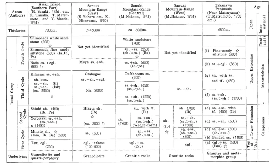
Awaji Island and established the stratigraphic sequence a s follows, from the lower,
M. Saito
shale (400) (e) Kitaama sandstone and shale (3300) ( f ) Nada sandstone and conglomerate (1100) (g) Shimonada fine sandy siltstone (370) (h) Shimonada sandstone (250)
In
1936,
T . SHIKAMA
studied the Akashi and Harima groups and stated that the former
group yields fresh water molluscs, plant remains
,
and
Parastegodon akashzenszs
,
and
from these fossils and the sediments, concluded that the group was deposited in the
littoral zone of a paleo-lake and that the majority of the fossils were transported after
death.
From the condition of sedimentation h e considers that the Akashi resembles that of the
paleo-Biwa lake deposits. The conditions of the Akashi become shallow upwards. The
geological age of the Akashi is stated to be upper Pliocene or Villafranchian. T h e Akashi
i s separated from the Harima with distinct umconformity.
The Harima is a
140
meters thick gravel deposit intercalating the Maiko shell beds,
Higashifutami formation and the Nishiyagi formation.
From the occurrence of
Palaeoloxodon namadzcus f nom the Nishiyagi formation, he
states that the age is not younger than middle Pleistocene.
F . T A K A I
(1936)
described
Parastegodon akashzenszs T A K A I
from 0kubo-mura, Akashi
district.
H. S A T O
(1937)
in his explanatory text to the geological map of the Niihama sheet in
the scale of
1
:75,000,
described the lake deposits and referred them to Pleistocene in
age.
K. SUGI
(1938)
studied the xenocryst in the sanukite distributed in the vicinity of
Takamatsu City.
T . S H I K A M A
(1943)
from the sea-bottom of ShGdo-shima reported on the occurrence
of
Stegodo~z sznenszs
,
Parelephas :trogontherzz, Palaeoloxodon namadzcns naumanni,
P. namadzcns setoenszs, P. namadzcus yabez,
P.
aomorzenszs, Sus cfr nzpponicns, and
Bzson occzdentalzs. These are considered to have been derived from the Nishiyagi for-
mation. The geogical age is middle Pleistocene according to him.
N. IKEBE
(1948)
in his paper on the letter nomination of the Japanese Cenozoic stated
that t h e Pleistocene groups of S. NAKAMURA
(1926)
should be subdivided into different
horizons according to area and that the age ranges from Pliocene to Pleistocene.
His subdivision comprises five groups as follows,
A - Stegodon elephantozdes, Vzviparus kosananus or the Ag& group
B
- Stegodon akashzenszs - Tuglans cine? ea - Metasequoia - G l yptostrobus - Sequoia or the Kuwanagroup, Akashi group and the lower part of the paleo-Biwako group and the age is indicated to be 11
C - Stegodon orzentalz s bearing fresh water molluscs and plant yielding group or the upper part of
the paleo-Biwako group and the age is 1 2
D - Elephas namadzcus naumannz or the H a ~ i m a group, Kyoto and Osaka older Pleistocene and is equal to JI
E - Mountain gravel beds or J2
S.
Miki
(1948)
a s a result of his studies on the fossil plants recognized seven horizon
and gave detail discussions on them. His seven horizons are, in ascending order
,
Pinus ttzfolza bed
-
lower Pliocene; Metasequoza bed - upper Pliocene; Palzurus bed-
lower Pleistocene; Cryptomeria bed-
middle Pleistocene; Larix bed - middle Pleistocene; Sapium bed-
upper Pleistocene; Aphananthe bed-Holocene
S . TORII
(1948)
surveyed the Pleistocene deposits in the vicinity of Higashiyama, Kyoto
City, and divided them into, from the lower, DGgahara bed, Taniguchi marine shell bed,
and Nakanochaya gravel. The geological age of the marine shell bed is stated to be
lower Pleistocene.
N. KURATA
(1948)
summarized the boring data and electric prospecting data from
below the Mitoyo alluvial plain of werstern Kagawa Prefecture, and stated that there
is a lignite bearing blue silt in the horizon about
100
meters below the ground surface.
The Geo1og.y o,f Kagawa and Northern Ehime Pre,fectures
7
K. SUZUKI and others (1948) surveyed the Agi! group and from the occurrence of
Stegodon elephantozdes, fresh-water molluscs and plant fossils stated that its age is
early or middle Pliocene in age.
T . SHIKAMA
and
E.
TAKAHASHI
(1949) reported on the mammals occurring from
Akiyoshi in Yamaguchi Prefecture, and stated that the fauna corresponds t o his upper
Kuzuu formation in Tochigi Prefecture. The age is stated to be
J 2 .M . YAMAGUCHI
(1949) in his survey of the sanukite of ShGdo-shima stated that the
eruption was during or after the deposition of the lower part of the Setouchi group and
before sedimentation of i t s upper part. From the lower part of the group he reports
Lzquzdambar formosana and Rosa s p . , and stated that the age is Pliocene.
T . MATSUMOTO
(1950) in his petrographical study of the Setouchi volcanic rocks, said
that Mt. Iino, Mt. Kiyama, Mt. Kokubudai and others which are composed of sanukitic
rocks are not the Mesa or Butte made by erosion but independent volcanos.
K. HIRAYAMA
(1950) surveyed the Wakimachi district, Tokushima Prefecture, and
described the stratigraphy of the Sambagawa series and Izumi group.
S.
MIKI (1950, 52, 53) wrote many short articles on the occurrences of plant fossils,
a l l of which are related to the sequence of the plants younger than the Pliocene in
southwestern Japan.
In these paper he reports that
Metasequoza occurs from Saida -mura and Sogo-mura
in Kagawa Prefecture and from the Ajina basin in Yamaguchi Prefecture.
M. NAKANO
and G. I M A M U R A
(1950) surveyed the Izumi group in the vicinity of
Kubo, Nakatado-gun, Kagawa Prefecture, and stated that the Izumi group i s thrust over
the older Pleistocene gravels and i s covered with the younger Pleistocene gravels.
G. KOJIMA (1951) studied on the stratigraphy and geological structure of
the
Sambagawa metamorphics in central Shikoku and divided i t into from the lower, Nishiiya
group and the Yoshinogawa group. The latter group is divided into three subgroups.
H. Y O ~ H I D A
(1951) studied the igneous rocks of the neighbourhood of Ishizuchi-yama
and gave some descriptions
.
H. HIGASHINAKA
(1951) studied in Awaji-shima, especially the lignite bearing deposits
and found that the sediments amount to 150 meters in thickness and overlie the Izumi
group and granite with unconformity. He also reported on the occurrence of
Anodonta
and other fresh-water shells.
0 .
FUKUDA
and Y. ANDO (1951) listed 11 named species of molluscs from the
Takatsukayama shell bed near Maiko. They also emphasized that the boundary between
the upper (Takatsukayama bed) and lower (Maiko bed) is a conformity and reported
Metasequoza from middle horizon of these strata and from it stated that the age of
the Mollusca bearing strata is Pliocene.
In 1951, K. FUJITA
and others wrote on the young deposits in the vicinity of Osaka
and Kyoto and called these the Osaka group. This group is subdivided into, from the
lower, Senriyama formation, and the Ibaragi formation, and from the former they
reported on the occurrence of benthonic foraminifers a s
Nonzon
,
Bulzmzna ,
planktonic
for aminif er a a s Globiger ina
,
and marine diatoms.
From this data they consider that the previously called lake deposits are marine in
their larger part. From the occurx ence of
Metasequoia from the Senr iyama for mation,
they correlate i t with the Akashi group and state the age to be 11.
R. MORIMOTO
and others (1952) in their study of the Osaka and Futagamiyama groups,
inferred that the age of the Setouchi volcanic activity in the Kinki region i s Mio -Pliocene.
In 1953, K. F U J I T A
studied the Setouchi supergroup and stated that the strata comprised
Metasequoza, all are correlated to the lower Osaka group and considered to be
11
in age.
Y. ANDO (1953) described the molluscan fossils from the Maiko and Takatsukayama
8
M. Saito
shell beds near Kobe City.
E.
TAKAHASHI
(1953)
gave a brief outline of the mode of occurrences and the sequence
of the fossil plants in different parts of Yamaguchi Prefecture based upon the works of
other authors
.
M. N A K A N O
(1955)
studied the Izumi sandstone developed in the Sanuki mountain
and stated that the young deposits distributed on its northern flank is probably Plio-
Pleistocene in age although no fossils have been found.
T .
SHUT^
(1953)
made a study on the o i t a group which he divided into from the
lower, Takio formation and the Tsuruzaki formation, and these correspond to 11 and I2
in age. The latter formation represents a aew cycle in marine transgression.
G. KOJIMA
(1953)
in his study of the structure of the basement of Chugoku and Shikoku,
described the distribution and characteristic features of the Cretaceous Hiroshima granite.
T . MATSUMOTO
and others
(7953)
compiled the Cretaceous System in the Japanse Island.
K. NAGAI and K. HORIKOSHI
(19.53,
1954, 1955)
surveyed the Ishizuchi group in the
neighbornhood of Ishizuchi-yama and they divided the group into two formations.
J . KATTO and J . N A K A M U R A
(1954)
discovered pollen of
Metasequoza, Lzquidambar,
N y s s a
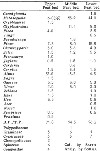
and others from the peat bed of Kitano in Saida-mura, Kagawa Prefecture.
M. SAITO
(1954)
in his article on the sequence of volcanic activity, and stratigraphy
of the sanukite bearing pyroclastic rocks of eastern Kagawa Prefecture gave descriptions
and discussion in concern to them.
In the same year, M. SAITO wrote on the young sediments distributed in western
Kagawa Prefecture and called them the Mitoyo group and from the occurrence of
Metasequoza, Sequoza, Pseudotsuga,
he correlated i t with the Akashi group.
M . S A I T O
(1955)
wrote on the gravel beds on the Yashima hill-tops, and stated that
they may occupy the upper horizon of the
Metasequoza
bed and be Plio-Pleistocene in age
R . SAKAMOTO
(1955)
in his study of the Cenozoic rocks in the southern part of Nara
stated that the Shirakawa-ike formation and Sabo formaion are contemporaneous and
range in age from I1 to 12.
S . KOKAWA
(1955)
studied the plant fossils from the Sabo formation and subdivided
the Shirakawa-ike formation into two parts and stated that there is no break between
them, from the lower part
Metasequoza
occurs and from the upper
Menyanthes, T r a p a
and
SczrPus
but not
Metasequoza.
Although the age i s not certain, the lower part is
taken to be a correlative with the Akashi.
S.
YAGI
(7955)
reported on the plant fossils from Gunchu-cho in Iyo province. Here
also
Metasequoza
besides others occur.
Y. KONDO and others
(1956)
reported on the discovery of
Metasequoza
from the
Tokoname group in Chita Peninsula, Aichi Prefecture and stated that the age is 11.
H. OZAKI
(1956)
studied the molluscan fossils from the Namigata formation, Okayama
Prefecture, and said that i t should better be referred to the Tertiary than to the Pleistocene.
M. SAITO
(1956)
in his explanatory text to the geological map of Kagawa, in the scale
of
1
:200,000,
described the geological sequence as follows, from the lower,
Ryoke complex; Izumi g r o u p ; Teshima formation (Miocene) ; Sanuki group (Mio-Pliocene) ; Mitoyo group (Pliocene) ; Yashima gravel (early Pleistocene)
K. NAGAI
(1956)
made a study on the Tertiary rocks of Ishizuchi- yama which he divided
into from the lower, Kuma group and the Ishizuchi group and he reported several plant
fossils and two larger foraminifers indicating the Eocene froni the former group.
K. NAGAI
(1957)
reported on the upper Eocene flora from the Kuma group, in the
Ishizuchi range
,
and described some important species, namely,
Nelumbo nippo~zzcnus
ENDO and
Sabalztes nzpflonicus
ENDO.
S . YAGI
(1957)
from the plant beds near Gunchu-cho in Iyo province, reports on the
occurrence of some fresh- water shells.
The Geo1og:y o,f Kagawa and Northern Ehime Prefectures
9
T . KASAMA
and K. FUJITA
(1957)
based upon their survey and the works of other
authors, described the geological features of the Setouchi area and discussed about t h e
inter correlation of the Cenozoic strata developed in the Setouchi geological province.
Y. TAKAHASHI
(1958)
reported on the discovery of
Metasequoza
from the south of
Komatsu City, Ehime Prefecture and named the deposit which yield the fossil a s the
Okamura formation. He stated that the age is Pliocene and gave a brief account of its
distribution.
E.
TAKAHASHI
and others
(1958)
called the silt deposits distributed on the sea-bottom
of Ube area, the Kusae s i l t ; this measures
100
meters in thickness and is sometimes
intercalated with tuff layers Besides fossil crabs it yielded
A n a d a r a , Tellzna
and
Ostrea.
Pznus
and
Tzlza
are also recorded from this silt and the age is stated to be Iz. Similar
facies occur on the sea coast of Murazaki near Yasuoka in the north of Shimonoseki
City.
M. HASHIMOTO
and H. KUSUMI
(19.58)
wrote on the lake deposits developed in Saijo,
Hiroshima Prefectune. These are divided by them into two parts, the lower of
30
meters
in thickness and intercalated with two or three peat beds, and the upper is ten meters
in thickness. These are correlated with the Ekoda stage.
M. ICHIHARA
and
J. OGURO
(1958)
surveyed the Akashi and Harima groups and
stated that the Maiko shell beds are interbedded i n the Akashi group.
C. NAKAGAWA
(1958)
studied the Izumi group in the upper course of the Shigenobu
River in Onsen-gun, Ehime Prefecture. On this occasion from the older Pleistocene beds
and from the silt a t the lower of the terrace deposits he found the pollen remains and
from a n analyses discovered pollen of
A l n u s , Pznus
,
Pzcea, Metasequoza, Fagus,
LycoPodzum
and stated that they correspond to the Akashi group.
Y. ARAKI
(1958)
reported on the occurrence of Pleistocene marine fossils from the
Mitachi and Konobe formations which unconformably overlie the Pliocene lake deposits
known a s the AgC group.
S . HANZAWA
(1959)
described two larger foraminifers from the basal conglomerate of
the Tertiary formation of the Ishizuchi mountains, namely
Fabzanza casszs
(OPPENHEIM)
and
Discocyclzna
sp. .
N. IKEBE
(1959)
wrote on the distribution of the primitive elephants in the Kinki
region and recognized four horizons, these are from the lower,
Horizon I - Stegodon elephantozdes - H z , Horizon 2 -Stegodon znsignzs sugz yamai, S shodoenszs, S . akashiensz s - 11, Horizon 3 - Stegodon orzentalzs and Elephas namadzcus naumanni - 12, and Horizon 4 - Elephas namadzcus naumannz - Jz
Y . TAI
(1959)
in his study of the Miocene microbiostratigraphy of West Honshu, re-
ported that the marine sediments are distributed a t Nadazaki -machi, KO jima -gun, Okayama
Prefecture, based upon the boring data of a well lowered to
161
meters in depth.
E . TAKAHASHI
(1959)
compiled on the occurrence of plant fossil, all of which are
related to the sequence of the plants younger than the Paleozoic i n West Honshu.
Y. ARAKI
(1960)
studied the geology of Mie Prefecture and subdivided the AgC group
into several formations and sedimentary facies. This group, a lake deposit is unconforma-
bly superposed on the Miocene and unconformably overlain with marine Pleistocene
deposits. The age of the lake deposits is stated to be Pliocene.
S.
HAYASAKA
and I . IWAI
(1960)
in their study of the Pleistocene marine fauna of
Chita Peninsula, Aichi Prefecture, wrote that the lower Tokoname formation (lake
deposit) is unconformably over lain with the marine shell bearing siltstone referred to the
upper Tokoname for mation.
M . SAITO and
Y .
BANDO
(1960)
studied the Plio-Pleistocene strata of the Inner Zone
of Shikoku, and described the geological structure.
10
M. Saito
ing the Harima hills in the Akashi district and divided i t into, from the lower, Akashi
group and the terrace formation. In the same year, M. ICHIHARA
discussed the Plio-
Pleistocene boundary in the Kinki district.
M .
SAITO (1960) reported on several types of sedimentary structures observed in the
Pliocene lacustrine sediments in Kagawa Prefecture.
Median Line,
with regard to work on this tectonic line, the following ones are of im-
por tance
.
Edmund NAUMANN
(1885, 1890) was the first geologist to describe the major geological
structure of the Japanese Islands. He divided the Japanese arc into four grand parts
based upon geological and geomorphological considerations, as,
Southwestern Japan Northeastern Japan
Inner zone Inner zone{
Middle zone Inner zone('nner Middle zone
Outer zone Outer zone
He called the divisional line between the inner and outer sides of Southwest Japan
"Grosse Medianspalte" and said that this line is a fissure and older than the "Fossa
Magna". I t is said to be an essential structure of the folded mountain arc. Also he called
the Setouchi zone of the outer side of the Inner Zone of Southwest Japan "Trummer Zone"
and believed that this "fragmentation" is a geological event of very much later date,
because Pliocene agglomerate and tuff breccia are developed on Sh8do -shima
,
Setouchi
district.
T . HARADA (1888, 1890) distinguished in southwestern Japan three longitudinal d i -
visions and two longitudinal tectonic divisions.
The former are called
(1)
t h e outer and (2) t h e inner zones of sedimentary rocks and (3) t h e core zone of gneisses and crystalline schists, and t h e latter (1) t h e outer and (2) the inner sidesHe described that this Median Line runs almost along the geological boundary between
the Izumi group and Ryoke complex in the islands of Shikoku and Awaji, and along the
upper coutse of the Tenr yu River in central Honshu.
Further he remarked on the inner side of Southwest Japan, and said that there are
developed four volcanic lines, almost parallel to one another and also to the Median Line.
T.
OGAWA
(1899-1902) drew the Median Line quite correctly, and described that i t was
formed a t a much later date than the construction of the general folded structure of the
land, preceded the Cretaceous marine transgression and expressed that a t least a part of
the line represents a zone of overthrust.
He pointed out the development of imbricate structure due to overthrusts in the Outer
Zone of Southwest Japan, as the effect of a horizontal thrust directed from the inner
side towards the outer and explained, as did NAUMANN
and HARADA,
the formation of the
Inland Sea as being due to the fragmentaion of the land and the depression of certain
blocks.
H. YABE (1915) described that the dividing line between the inner or northern side
and the outer or southern side in Southwest Japan is a plane of separation of tectonic
origin and to mark the boundary line between the Izumi sandstone and gneiss (including
older granite) on one side and the crystalline schists and the lower Chichibu formation
on the other and this came first to existence a t the end of the Mesozoic Era or a t the
beginning of the Cenozoic.
H. YABE (1917) with regard to NAUMANN'S
opinion on the formation of the Inland Sea,
wrote a s follows,
"The fragmentation of the earth's crust and t h e subsequent block-movement I believe certainly took place i n t h e reigon now occupied by t h e Inland Sea; I a m doubtful only as to whether t h i s was the sole agent which took part in t h e formation of the water basin, that is whether i t was without t h e association of another action, as for instance t h e positive movement of sea level.
The Geology o f ' Kagawa and Northern Ehime Pre,fectu~es
11
The positive movement of the sea level can be wholly or at least partly the direct cause, though the present configuration of the water basin was certainly modeled after the pre-existing faults and joints which have rendered the erosion of the encroaching marine water easierThe encroachment of the marine water to a basin may or may not be consequent to the formation of the tectonic basin"
H. YABE (1926) in his paper on the MedianLine of Southwest Japan and its position on
the island of Kyushu, emphasized that the date of the first: appearance of the Median
Dislocation Line of Southwest Japan is post-Urakawa Epoch (the Japanese Senonian) and
pre- Akitsu (the Japanese Paleogene)
.
Y. OTUKA (1935) from field evidence stated that the Median Line was developed be-
tween the time after the deposition of the Izumi sandstone and before the deposition of
the Izumi sandstone and before the deposition of the Eocene formations. It has been
active a t least three times, of which the latter two are reverse faults.
$5.
YEHARA
(1936) stated that there are four activities of the Median Line, the first i s
post -Cr etaceous to pr e -early Tertiary
,
the second is early Miocene, the third i s post.
Tertiary to pre-Pleistocene
,
and the fourth is post-Pleistocene.
S.
YEHARA (1937) stated that the Izumi sandstone is thrust over the schist along the
Median Line and the outcrops are well observed at Yuyaguchi, Tobe, and Inuyose-tBge,
all in Ehime Prefecture.
K. KAWADA
(1939) stated that the schist and Izumi sandstone are thrust up on young
deposits a t Shobudani along the Kino River in Wakayama Prefecture.
R . SUGIYAMA
(1939) studied the different rocks distributed along the Median Line in
Nagano and Shizuoka Prefectures .
S . TSUBOI (1939) on the basis of SUGIYAMA'S
study described that the boundary line
between the Inner and the Outer was covered with the Izumi group. He called i t the
Median M ylonitization Zone.
K. WATANABE
(1939) wrote on the origin of the Median Line in southwestern Japan.
T . KOBAYASHI
(1941) recognized four activities of the Median Line, differing from
YEHARA'S
view in that a Kashio phase may be established in which the Sambagawa-,
Mikabu-, zones were invaded by the Ryoke gneiss. He states that the Median Line
was completed just after Miyako time.
H.
FUJIMOTO
(1953) recognized four times of activity of the Median Line.
G.
KOJIMA (1953) in the petrographical study of the Sambagawa series, described that
the Sambagawa metamorphic zone was formed under the influence of southernly up-
thrusting movement of the Ryoke Kratogen, in other words, Sambagawa metamorphism is
a type of dislocation metamorphism of relatively large scale. I t seems to him to be
meaningless to draw a clear line of demarcation between the Inner and the Outer Zones.
K. NAGAI (1954) stated that the activity of the Median Line differs according to region,
especially in western Shikoku there can be recognized three places. The first between
Mishima and Ichinokawa, the second between Ichinokawa and Kaminada, and the third
between Kaminada and Nagahama. The first has been active to recent time and i s a
normal fault, and its vertical displacement is the greatest. The second has not moved
since the building of the Takano tuff (Ishizuchi group). The third shows evidence of recent
movement but its vertical displacement is not as great as that of the first mentioned.
K.
NAGAI (1955) classified the alluvial deposits in the east of Ehime Prefecture, and
stated that the oldest is probably middle Pleistocene in age and the Izumi sandstone is
thrust over i t and is named the Okamura fault. From the distributions of the alluvial
deposits i t can be inferred that the fault has been recently active.
T. SAWAMURA
(1955) from seismic records and crustal movements during the Nankai
Earthquake of 1946, assumed that the Median Line passes near the north of the Yoshino
Biver bridge in the north of Tokushima City.
12
M .
Saito
K. NAGAI
(1958)
stated that there are four activities of the Median Line in Shikoku.
The first i s post -1zumi pre-Kuma (Ichinokawa phase) , the second is post-Kuma pre-
Ishizuchi (Tobe phase)
,
the third is early Pleistocene (Niihama phase)
,
and the fourth
is Holocene (Shobudani phase).
11.
Geology
sfthe Inner Zone
ofShikoku
The area in which the geology was studied extends from the southwestern part of
Matsuyama City in Ehime Precture, northeastwards along the northern foot of the
Ishizuchi and Asan mountains, via Niihama City in the same Prefecture to Sambonmatsu
City in Kagawa Prefecture through Mishima City i n Ehime Prefecture and Kanonji City
in Kagawa Prefecture. This covers a distance of about
200
kilometers i n east-northeast
to west -southwest direction and a breadth of about
30
kilometers in maximum, thus the
area is more or less in belt form.
For the sake of descriptions as well as of the development of the different formations,
this belt -like area is subdivided into several provinces a s ,
1
)Matsuyama Province, includ-
ing the area from the environs of Matsuyama City north- eastwards to near the Nakayama
River in Shus6-gun, Ehime Prefecture
;2)
Niihama- Saijo Province, extending from the
Nakayama River just mentioned, east -nor theastwards to Iyo-Mishima City
;3 )
Mitoyo-
Nakatado Province, extending from Iyo-Mishima City northeastwards to the Doki River
in Kagawa Prefecture, and
4 )
Eastern Province, which includes the area from the
Doki River east -northeastwards to Tomita in Okawa -gun, Kagawa Prefecture .
Descriptions
of the paleo- lake deposits will be undertaken according to each respective province.
The stratigraphical relationship between the Sambagawa metamorphics and the Ryoke
complex and the granite remains unknown owing to their areas of development being
different, the latter two being in the Inner Zone of Southwest Japan and the former in
the Outer Zone of the same region. The Izumi group unconformably covers both the
granite and Ryoke metamorphics, but not the Sambagawa metamorphics. The granite
has intruded the Yamaguchi group. Although the direct relationship of the Sambagawa
to the other two remains unknown, the general descriptions are given because they form
the foundation of the present area. The descriptions of the different rock units are given
in the following lines.
A Sambagawa Wetamorphics
Although t h e stratigraphical relationship of the Sambagawa metamorphics to the Ryoke complex, younger granite and t h e granodiorite remains unknown, their development a s t h e foundation rocks in t h e studied area is important, and t h e description now follows
The Sambagawa metamorphics with t h e type locality in t h e Sambagawa valley of t h e province of Kozuke in t h e Kwanto district of central Japan i s a name applied to the crystalline complex developed there. Since i t is generally believed t h a t t h e crystalline schists in Shikoku i s closely connected with those of Kii, Chubu and t h e Kwanto districts t h e name i s also applied t o similar rocks distributed i n t h e present district T h e Sambagawa system or metamorphics as they may be called include i n t h e present area black schist and green schist, the latter in a position lower than t h a t of t h e former
.
The green schist is very compact, well indurated and shows excellent schistosity with a general trend of east-west and dips towards t h e north a t above 30'-50" This schist i s developed in t h e southern part of t h e Shikoku mountain range especially in the Matsuyama and Niihama-Saijo p~ovinces. It i s distributed parallel with t h e Median Line and extends from t h e western sea coast i n t h e Matsuyama province, northeastwards to the south of Komatsu City in t h e Niihama-Saijo p ~ o v i n c e , where i t is overlain with black schist
T h e black schist is mainly graphite schist with good luster, rather soft, showing schistosity with a general trend of east-west with northward dips of about 30-50 degrees similar t o those of t h e green schist This schist i s developed in t h e northern half of t h e Shikoku mountain range extendnig
The Geolog,y o,f'
Kagawa
and
Northern Ehzme Pre,f'ectures
.13 from t h e south of Komatsu City northeastwards to t h e south of Mishima City in t h e Niihama-Saijo province. In t h e farther south of t h e black schist there is developed t h e green schist and on i t s southern side again t h e black schist appears, because there is developed a n anticlinal structureIn t h e Matsuyama province t h e green schist with approximately east-west trend and northward dip Table 1 , Stratigraphic Classification of the Rocks distributed i n the Present Area
Age
1
Group1
Formation Predominant Lithofacies1
ThicknessPleistocene
-. - . - ..
L " ~ ~ p ~ ~ ~ ~ a c e
I
Gravel, sand and clay1
l 0 mHig2:b2::ace
I
Gravel, sand and tuffaceous clay1
10-15mUnconfor mity
Yakeotoge gravel
1
Gravel and granule sand1
20-50m Unconfor mityKawauchi Taman
Upper member : granule sand, pebbly gravel 30-50m Lower member : alternation of sand and silt
1
O m mitySanuki
Sanukite lava
Hornblende andesitic and pyroxene andesitic agglomerate
unconformity
Compact white tuff Biotite dacitic tuff breccia
Conglomerate and stratified sandy tuff Unconf or Kokubudai Local Oda loom(+) 50-100m Miocene Eocene Tonosho Kuma Local unconformity
Yashima
/
Basic tuff and tuff breccia1
50m UnconformityShikai
1
Alternation of coarse- and medium grained sandstone1
40-80mLate Cretaceous Paleozoic 30-50m Ikisue Unconf or mity
Myojin
/
Conglomerate Alternation of sandstone and mudstoneI
4 m m Alternation of sandstone and calcareousNimyo sandstone
1
300mBasal conglomerate Unconformity and thrust fault
Alternation of granule sandstone and siltstone intercalating three or four thin lignite layers
Basal conglomerate
I
Muya1
Alternation of sandstone and shale1
1600m IzumiOsakagoe
I
Alternation of sandstone and shale interca- lating conglomerate and tuff layers1
2000m1
Massive mudstone~predominant, with strati-Hiketa fied shale
1
2000mTsubasayama
I
Medium-grained sandstone intercalatingthin mudstone and thin conglomerate layers
1
30-300m ShiroyamaI
Ar kose sandstone and conglomerate1
100-3OOmUnconfor mity Ryoke complex
Hornblende -biotite granite, biotite granite, granodiorite , gneissic granite, mica-schist, banded gneiss, hornfels, unaltered Yama- guchi facies of clayslate, greywacke, chert, schalstein
Stratigraphic relation uncertain
Sambagawa metamoIphics
I
Black-schist (mainly graphite-schist) and green -schist (mainly chlorite -schist)14
M .
Saito
makes about five to six anticlinal and synclinal structures and on t h e southern side of this folding structure there is distributed t h e black schist, which i s situated above that of t h e green schist. T h e general trend of the axis of the mentioned anticlines and synclines i s parallel with t h e general trend of the schistosity Near the boundary of t h e Matsuyama and Niihama-Saijo provinces, t h e green schist has developed about five to six anticlines and synclines also with east-west trends and on the southern side of this folding structure there is developed t h e black schist also in a stratigraphic position higher than the green schist In t h e Niihama-Saijo province there is developed only a single very large anticlinal structure having t h e same trends a s t h e schistosity of t h e schists and on its southern side is distributed the black schist
T h e northern limit in distribution of t h e green schist in t h e Matsuyama province is defined by t h e Median Line, whereas in the Niihama-Saijo province t h e northern limit in distribntion of t h e black schist is also the Median Line and t h e Pliocene lacustrine deposits These schists a r e in contact with t h e Izumi group in t h e larger part of their distribution and with t h e lacustrine deposits just men- tioned only in a small portion
In the Niihama-Saijo province, the black schist i s cut by the Shimona-Tsuneyama fault which trends almost east-west and dips towards the south a t 45 degrees, being a thrust from t h e south Along this fault there are found several intrusions of dolerite In the same province, t h e black schist is cut by the Ryudzan fault which trends in northeast-southwest direction and with dips of 80 degrees towards the west ; this is a normal fault not associated with intrusive igneous rocks T h e exact dating of these two faults is difficult to determine, but i t can be said that both were developed before one of t h e movements of t h e Median Line, but which of the movements is difficult to determine Since t h e extension northwards of the Median Line of both of the faults cannot be determined in t h e field from structural evidence, i t may be considered that they were associated or had relation with t h e folding structures which they cut and were developed a t an early date. Their date of development may be after the deposition of t h e Cretaceous Izumi group
B
.
Yamaguchi GroupThe stratigraphical relationship between t h e Yamaguchi group and the Sambagawa metamorphics i s unknown because no contact between them has been observed by anyone in t h e field On t h e other hand t h e relation between the Yamaguchi group and t h e Ryoke metamorphics can be observed in the field, and t h e latter are only the metamorphosed facies of the former, and without superposition This metamorphism is related to granite plutonism, accompanied of intense granitization. T h e metamorphosed zone extends i n the south of t h e longitudinal axis of t h e Setouchi Sea and i n t h e northern side there is distributed the Yamaguchi group
The Yamaguchi group consists of nearly 4000 meters thick clayslate with intercalated layers of schalstein (about f i v e ) , each of which measure from 100-500 meters in thickness T h e general trend of t h e group is N 60"-80" E with dips of 50"-80" towards t h e NNW a s measured in the vicinity of t h e Kojima Peninsula in Okayama Prefecture, and i n t h e vicinity of northwest of Shddo-shima in Kagawa Prefecture. Elsewhere in the distribution of the Yamaguchi group measurements have not been made for the strike and dip but t h e general trend is east-west with northward dips although sometimes with southward dips. There is developed in t h e Kojima Peninsula a n anticline with axis trending east-west with the wings dipping a t 60 80 degrees to t h e north and south respectively.
C
.
Ryoke MetamorphicsT h e Ryoke metamorphics are the metamorphosed Yamaguchi group rocks and consist of brownish-
I ed mica-schist, banded gneiss, blackish purple hornf els, grayish white quartzite, and in part with
milky white crystalline limestone These have a general trend of nearly east-west and dips to the north and to the south according to places T h e distribution of t h e metamorphic rocks is rather patchy. These rocks ar e distributed along t h e coastal regions of Ehime and Kagawa PI ef ectures The most intense degree in metamorphism i s along t h e coastal areas of t h e two Prefectures
In the Matsuyama province, t h e Ryoke is distributed from Matsuyama City i n t h e west via Fukumiyama eastwards to Tambara-cho, trending roughly i n east -west direction with northward dip of 40-60 degrees ; i t s width is about two kilometers and i s distributed in belt form. On i t s northern side is developed the granite which is related to the Ryoke metamorphic rocks and on its southern side i s distributed Izumi group, which i s not altered In the islands offing t h e Takanawa Peninsula
The Geo1og.y of' Kagawa and Northern Ehirne Preftctures
t h e Ryoke has strikes of east-west with northward dip of about 50 degrees.In t h e Niihama-Saijo province t h e Ryoke metamorphic is distributed on 8-shima(island), where t h e strike i s east-west with northward dip of 50 degrees The mica-schist in this island has on its southern side the distribution of granite, which is the eastern extension of t h e granite mass men- tioned in t h e Matsuyama province
In Kagawa province, t h e Ryoke metamorphics are distributed on t h e islands offing t h e coast and along t h e coastal area, and the granite i s developed on both northern and southern sides of it. In t h e island of ShBdo-shima, where a t Yasuda, Uchinoumi-cho, t h e Ryoke metamorphic measures about 400 meters in thickness and consists of mica-schist, quartzite and hornfels and the diabase has been observed a t Kuroiwa, Tonosho-cho in the same island. The strike is east-west with northward dip of 60 degrees. In the Shioaku islets offing the coast of Kagawa Prefecture, the Ryoke shows a general strike of east- west with northward dips of about 60-70 degrees, and a t places as on Ushi- jima t h e Ryoke dips at about 50 degrees to the south Here t h e rocks consist of mica-schist, hornfels with subordinate crystalline limestone on Shishi-jima Mica-schist of t h e Ryoke has also been observ- ed on t h e eastern side of Kiyama hill in the south of Sakaide City in Kagawa Prefecture. T h e strike is east -west with northward dip of 50 degrees A t Nagasumi, Manno-cho, Kagawa Prefecture, the1 e is exposed hornfels with strike of east-west and is intervened in granite; it carries sillimanite ore.
The Ryoke metamorphics a r e thought to have been developed as a result of granite plutonism, accompanied of intense granitization, probably beginning from and during late Paleozoic according to KOJIMA (1952), and is thought to have intimate relationship with the orogenic phase which occurred before t h e deposition of the Carnic Mine series and after deposition of the late Permian Akiyoshi limestone group. On t h e other hand, T KOBAYASH~ (1941) stated that t h e Ryoke metamor- phics were developed during t h e Jurassic-Cretaceous associated with the Sakawa orogeny, and he considers t h e Akiyoshi orogenic phase to be late-Paleozoic to early Mesozoic in a g e , for which there seems to be no direct field evidence. T h e writer considers t h e development of t h e Ryoke metamorphics associated with the Akiyoshi orogenic phase and to be post-late Permian and pre-Carnic to be in age
D. Granite
The granitic rocks intimately related to Ryoke metamorphic rocks comprise hornblende-biotite granite, biotite granite and granodiorite These granitic rocks are distributed throughout the four provinces distinguished in this article, being developed particularly in their northern parts, in the islands offing the coasts of Ehime and Kagawa Prefectures and in t h e southern half of t h e Setouchi area Within this area of distribution of the said granitic rocks there are found fine grained granite and porphyr itic granites intruding the aforementioned granites Aplite and pegmatite a r e found in association with older granites along t h e eastern coast of Kagawa Prefecture. Diorite in the form of stocks and dikes intruding the older granites.
There is another granite mass which has intruded t h e two different ones above mentioned This i s found in the northern half of t h e Setouchi area and in t h e southern half of Chugoku district and is considered to be Cretaceous i n age according to G KOJIMA (1952). This intrusion i s t h e largest one of batholithic t y p e in Japan The one which is related to the Ryoke is called t h e Ryoke granite and i t s age of intrusion is considered to be post-Paleozoic to pre-Izumi in t h e present area, but when viewed from a broader area, the age of intrusion is post-Paleozoic to pre-Carnic.
The Ryoke granite i s characteristic in showing the development of schistosity with almost east- west trend, and according to M. MORISHITA (1934) the granite in the Takanawa Peninsula also shows east-west trend of its schistosity. According to B YOSHIKI (1934) t h e granite exposed a t Manno-cho, Kagawa Prefecture also shows east-west trend of its schistosity, and that this direction i s in agreement with that of t h e Median Line.
Measurement of the joints of t h e granite i n the marginal portions of the Pliocene lacustrine d e - posits a t Manno-cho and Kotohira-cho both in Nakatado-gun ; Kagawa-cho in Kagawa-gun ; Aji-mura, Kida-gun; it was found that ENE-WSW and NNW-SSE directions a r e developed. The dips are generally about over 60 degrees. Unconformably overlying t h e Ryoke granites just mentioned a r e the Izumi group with basal conglomerate or basal arkoses, t h e Miocene Tonosho group, the late Miocene Sanuki volcanics, the Pliocene Mitoyo group and the Pleistocene deposits, according to areas a s will be mentioned in later pages