Copyright@SPSD Press from 2010, SPSD Press, Kanazawa
Climate-Sensitive Urban Design in Cold Climate Zone: The City of Erzurum, Turkey
Dogan Dursun¹* and Merve Yavas1
1 Department of City and Regional Planning, Ataturk University
* Corresponding Author, Email:[email protected] Received 13 December, 2013; Accepted 23 July, 2014
Key words: Cold Climate, Built Environment, Urban Design, Sustainable Development Abstract: The main objective of this paper is to explore the contradictory relationship
between the climate and physical structure of the built environment in Erzurum as one of the coldest climate cities in Turkey. It mainly questions whether the urban form and geometry (size, density, street orientation and ventilation), height and shape of the buildings and vegetation in selected districts of Erzurum are compatible with the cold climate conditions. In this direction, disturbances, vulnerability of urban ecosystem, construction practices, street orientations, settlement patterns, housing typology, density, average height, hard-surfaces, distances, flora and density of green areas are analyzed. The findings show that the urban built environment in Erzurum (City Centre, Dadaskent and Yildizkent districts) is not consistent with the cold climate conditions. Urban heat island, urban sprawl, ventilation problems and existing air pollution, and high temperature differences in the city are the threatening factors for ecologically sustainable urban development. In the context of this study, it is aimed to formulate urban design guidelines for the city of Erzurum in cold climate zone. Urbanization and urban form of the three different districts, which are the focus areas of this research, must be reconsidered from a climate sensitive perspective, otherwise new development areas will not be energy efficient and resilient against changes, surprises and risks. For ecologically sustainable urban development, climate sensitive urban design guidelines must urgently be prepared and implemented for Erzurum.
1. INTRODUCTION
Due to climate conditions, urban settlements located in cold regions have certain characteristics. Winters are the long seasons affecting the everyday lives of the people. Heavy snow fall, frost, the short day length, icy roads and sidewalks are the main components of living in such urban areas. Cities located in cold climate regions are characterized by this climatic condition because of the challenges and opportunities presented. The impacts of cold climate can be observed in urban life as minimized outdoor activities, more energy consumption, limited recreational activities and types of transportation. Thus, the cold climate conditions force urban planners to deal with different aspects of urbanization, planning and climate conditions. In the literature, there is a growing interest about climate sensitive urban design, but in Turkey there is a limited amount of research related to this issue (Basibuyuk, 2005; Caliskan, 2012; Caliskan & Matzarakis, 2013; Caliskan, Cicek, & Matzarakis, 2011; Ercoskun, 2007; Girginer, 2006; Guclu, 1988;
Kuscu, 2010; Sahin & Dostoglu, 2007; Simsek & Sengezer, 2012; Soysal, 2008). It is not only the problem of academic research fields, but also of urban planning practices. Although knowledge of the relationships between climate conditions and urbanization is growing, the same scale impact cannot be seen in the application of this knowledge on urban environments.
The necessity of taking cold climate factors into urban design consideration has been detailed especially in the Northern country literature (Pressman, 1985; 1995; 2004; Ebrahimabadi, S., Johansson, C., Nilsson, K.L., 2012;
Milosovicova, J., 2010) providing a framework for this study focused on the city of Erzurum in Turkey.
Erzurum is a city situated at 1757 meters above sea level in the east of Turkey with a population of 780,000 in 2011. It has a humid continental climate according to the Koppen Climate Classification which is one of the most widely used climate classification systems (Kottek et.al, 2006). As it is stated in this data, a humid continental climate is a climatic region typified by large seasonal temperature differences, with warm to hot (and often humid) summers and cold (sometimes severely cold) winters. Erzurum is one of the coldest cities in Turkey with its very cold winter months averaging a minimum during January of around -16 °C. Temperatures fall below -30 °C each year and the record for the lowest temperature was - 37.2 °C in December 2002. Despite all these climatic data, the built environment in the city Erzurum does not show winter city characteristics.
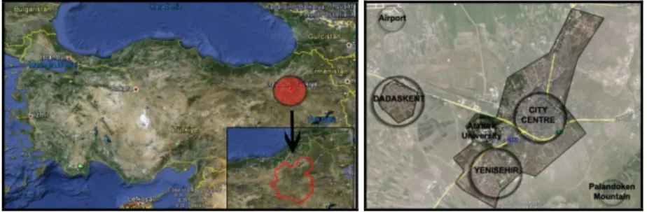
As it is observed in the main decisions, cold climate conditions have not been evaluated as an input for the city planning practices. There are some accidental developments in the city consistent with the climate conditions but Erzurum needs a more detailed urban design brief. In this context, three different districts of Erzurum - Kent Merkezi, Yenisehir and Dadaskent - are decided to, in this study, present existing situations of the built environment according to a climate sensitive approach (Figure 2). They are selected, because in terms of the settlement pattern they have different characteristics.
While the city centre has highly dense, narrow and deep streets, Yenisehir (a new city) displays more organized characteristics with its middle range density, five-storey housing areas and parks. On the other hand, Dadaskent which is the satellite city of Erzurum is located on the plain having a high ground water level, causing an urban sprawl.
In this context, this study evaluates the compatibility of urbanization practices in Erzurum with cold climate conditions for the sustainability of regions. Within this context, three subject areas are of particular interest: (1) urban geometry, canyons and street orientation (2) settlement patterns and land uses of selected districts (3) density. The main aim is to investigate the characteristics of settlements by addressing cold climate factors in the region.
The findings show that land use and urbanization processes in Erzurum are the factors not planned according to the climate conditions. With respect to the research aim, the research questions are as follows:
Main Question:
What are the inconsistencies between urban planning practices and climate factors in Erzurum?
Sub-questions:
Are cold climate factors in the city adequately reflected in location choices?
Are the street geometry and orientation in Erzurum planned according to the changing climatic conditions between winter and snow-free seasons?
Are there any perceived effects of climate factors on urban form in Erzurum?
Figure 1-2. Location of Erzurum and Case Study Areas: City Centre, Yenisehir, Dadaskent
The study focuses on the relationship between the built environment and cold climate conditions in terms of the urban design practices. First, the literature on the climatic aspects of cities in cold climates is reviewed and the characteristics are described. Second, the study concentrates and evaluates the existing situation of selected districts of the city of Erzurum in the frameworks of design-based factors such as urban geometry, density, building height to street width (H/W) ratio, the sky view factor (SVF), the building volumes, orientation of the streets, ventilation and the particular land use (Milosovicova, J., 2010). Third, the criteria for climate sensitive urban design in cold climate regions are summarized as an exemplar for the other cities in the same climate zone of Turkey. Finally, discussion for the current and future situation of Erzurum is made by considering the recommendations by climatologists and climate-specialized urban designers/planners in the literature.
2. CLIMATE CONSIDERATION AND URBAN PLANNING
For the climate sensitive urban planning, provision of outdoor comfort is the key objective (Ebrahimabadi, S., Johansson, C., Nilsson, K.L., 2012).
Although it seems in the literature that there are many studies related to the climatic conditions and urbanization, unfortunately they omit the problem of urbanization in cold climates. In order to develop a theoretical framework, a limited number of cold climate studies are evaluated and summarized in the following part.
As it is stated above, maximization of outdoor comfort for the residents is the major objective of urban planners in the process of climate-sensitive urban design (Ebrahimabadi, S., 2012). There are three categories of outdoor activities: necessary activities, optional activities and social activities (Gehl, 1996; 11-13). Quality of urban space or outdoor comfort does not have an effect on necessary activities but it has a big influence on the other two activities, optional and social ones (Ebrahimabadi, S., 2012). On the meterological side, climate factors such as wind, sun, radiation, temperature, humidity and rain influence outdoor comfort. On the other hand, the feeling of comfort is influenced by the context including design and function, environmental interaction containing lightning and noise, and psychological aspects such as adaptation, experienced and perceived control (Ebrahimabadi, 2012, p.5).
The winter extends over a large part of the year in the north regions by generating deep impacts on the patterns of urban life. As it is stated by
UM
Pressman (2004, p.5), there are some characteristic features in cold regions:
temperature normally below freezing; precipitation is often in the form of snow, short daylight and sunshine, and seasonal variation. These conditions restrict the activities of people in urban life by reducing the variation of outdoor activities. Snow and ice on the streets, freezing temperatures, frost and limited sunshine hours create unpleasant situations for the inhabitants.
On the other hand, for some people, winter conditions provide a beauty of nature and some recreational and sporting activities can be made under these conditions. The task of urban planners under these circumstances is to incorporate climate conditions into planning practices (Ebrahimabadi, 2012).
In this process, reduction of inconvenience, protection from winter based stressors and utilization from the beneficial aspects should be the strategies necessitating highly creative approaches (Pressman, 2004, p.23). A climate sensitive urban design process in a cold climate region requires the clarification of the goals for all city scales. There are three scales of urban place: macroscale (a whole city), mesoscale (district and building group), and microscale (buildings) (Pressman, 2004; Ebrahimabadi, 2012). Urban planning and design is mostly related to the whole city form and districts and building groups. The compact or sprawled forms of the urban environment, placement of buildings, street dimensions and density are the instruments of urban design for a climate sensitive approach. Achieving climate sensitive design necessitates the understanding of climate conditions and the existing structure of urban design elements. Through design, recommendations can be made for the development plan with the aim of reducing the negative impacts of winter conditions on inhabitants.
Within this context, three subject areas: urban geometry, canyons and street orientation; settlement patterns and land uses; and density, are explained in the following part with the aim of clarifying the subjects used in the analyses of Erzurum.
2.1. The Design Based Factors
In this study, design based factors summarized by Milosovicova (2010) will be used by combining and excluding some of the elements such as the size of the city and water in urban areas. Size of the city is excluded due to the discussions about its reliability on the explanation of the correlation between the city size and the urban heat island. Water is the other factor excluded because of the cold weather conditions and inexistence of the natural water surfaces in Erzurum. The other design based factors used in this study have a decisive role in determining urban climate and outdoor comfort by influencing the urban heat island, shading and air circulation.
Urban geometry: Building height to street width (H/W) ratio, the sky view factor (SVF), orientation of the streets
Density and compactness
Settlement patterns and particular land use 2.1.1. Urban Geometry
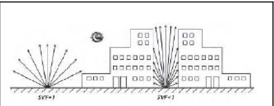
Urban geometry is one of the most important factors determining the urban climate and outdoor comfort. H/W ratio and sky view factor (SVF) are the geometry related indicators showing the impact of insolation on urban climate. In the H/W ratio, while H shows the height of the buildings, W displays the spacing (width) between them. The value of this ratio demonstrates how much sunlight and radiation reaches the street ground and
heats the air near the ground. On the other hand, the SVF shows the ratio of sky visible from the middle of the street (Milosovicova, 2010).
When the ratio of H/W is equal to “0”, there is no building and sunlight and insolation is absorbed and later released towards to the sky. An urban canyon with a ratio below 0.5 is named as a shallow street canyon. In a medium density area which refers to the ratio of H/W around equal to 1, radiation strikes other buildings and the ground and is absorbed near the ground level. It is called a uniform street canyon. In the case of high density areas, the H/W ratio is nearly equal to 4 or more and the radiation cannot reach the ground level. If it has a deep street canyon form, absorption stays high above the ground level. As it can be understood from these different values, the higher the ratio of H/W, the lower the heating of the urban environment. A higher H/W ratio restricts the release of heat into the atmosphere at night and slows down the night cooling of the urban environment (Milosovicova, 2010; Shishegar, 2013).
Figure 3. The SVF is equal to 1 if there is no obstruction in the horizontal area; if the street mid-point is surrounded by buildings, it is lower than 1(Milosovicova, 2010, p.24)
Canyon geometry is the other term used for the evaluation of the street geometry as an urban parameter in climate based studies. It is an artefact of an urban environment similar to a natural canyon and basic units of the urban surface can be seen repeatedly throughout urban areas. Horizontal and vertical surfaces and combinations between them produce urban canyons. In order to use the H/W ratio as a value for the mitigation of the negative impacts of urban heat island in our study, we use Emmanuel’s (2005, p.39) suggestion for the optimal values of H/W ratio of an urban canyon as 0.4-0.6 to keep minimal heat in summer and enhance it in winter. Although the optimal ratio is suggested, it has some deficits such as the exclusion of different seasonal impacts and factors such as vegetation and anthropogenic heat production. In fact there is no clear answer for the appropriate H/W ratio of urban canyon and there is no right H/W ratio (or sky view factor) generally applicable in all conditions. However, as it is stated by Shishegar (2013, p.56), the H/W ratio affects the quantity of solar energy obtained by street surfaces (facades, roofs and ground) and decreases of the H/W ratio increases solar access in the street. Therefore, case studies should be made for every particular region and planning situation involving the overall density of the area, street orientation and greening measures (Milosovicova, 2010).
For the determination of urban geometry, building volume is the other important factor. If the surfaces of buildings are large, the reflection and absorption of solar radiation will be high and the heat release will be later.
Therefore, the volumes of buildings can be considered as a factor having an
impact on the urban climate. In this process, the question of what type of building is the most appropriate one for climate sensitive urban design becomes important. As it is stated by Milosovicova (2010, p.25), the compact multi-unit buildings are the most preferable ones due to their smallest proportion of walls and roofs. Owing to these characteristics, they are most likely to avoid multiple sunlight reflections and solar radiation absorption, as well as the emmitance of heat from buildings through walls.
In the urban environment, different situations emerge according to the streets’ orientation. The urban parameters used in these studies are the airflow in an urban area, solar exposure of open areas and buildings, the thermal comfort of people walking on the streets, outdoor and indoor environments of cities, solar access inside and outside the buildings, and urban ventilation as well as the potential for cooling of the urban system (Emmanuel, 2005; Herrmann and Matzarakis, 2010; Milosovicova, 2010;
Shishegar, 2013). Therefore, street designs have to be considered in the urban design process with all the complexity of seasonal differences. While the street should provide protection from the sun in summer months, it should also facilitate solar access during winter periods. These issues necessitate compactness and openness to the sky.
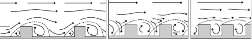
Urban airflow as one of the urban parameters has to be considered in climate sensitive urban design. The interaction between wind and the built environment is the decisive factor of the urban airflow pattern. It is essential for human heat, outdoor and indoor thermal comfort, and urban microclimate due to its cooling and mitigating effects on the urban heat island. Thus, design of the built environment or street orientation and geometry has to be considered as one of the key factors for the formation of an urban airflow pattern. In the literature, three airflow regimes are defined on urban surfaces based on the aspect ratio of H/W (Fig.4).
Figure 4. Airflow regimes: (a) the isolated roughness regime; (b) the wake interference regime; and (c) the skimming regime (Shishegar, 2013, p.53)
Shishegar (2013) stated that the isolated roughness regime takes place between well spaced buildings if there is no interaction between windward and leeward flows. When the H/W ratio increases, it produces a wake interference regime by disturbing wakes. As seen in the figure (c), an increase in the H/W ratio isolates the street canyon from the circulating air in the urban layer above the average height of buildings and thus, a circulatory vortex is created in the canyon. It is called a skimming regime and is frequently seen in urban areas. There is a clear relationship between street geometry and the microclimate in urban areas. Narrow and wide street canyons have different effects on wind speed and thus on urban microclimates. Additionally, building heights have big impacts on better ventilation. As stated in the studies of Milosovicova (2010) and Shishegar (2013), strategical placing of a few blocks of high-rise towers improves the velocity in the street canyon if the airflow is parallel or perpendicular to the canyon. The temperature can be increased or decreased in a street canyon according to the placement of high rise buildings. On the other hand, provision of adequate width between streets and courts should be considered
in the urban design process because it improves air exchange within the urban canopy layer. The configuration of streets such as straight and parallel to each other affects the airflow and promotes air movement in urban areas.
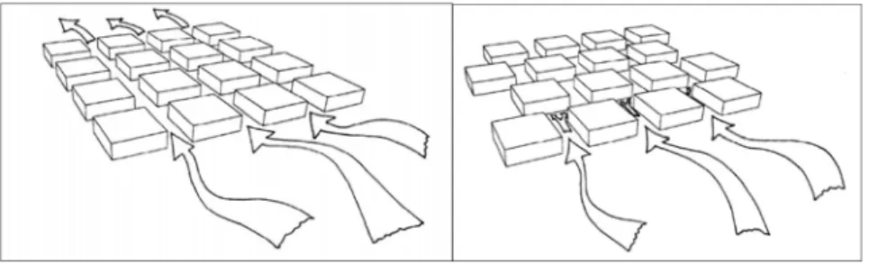
While straight and parallel streets improve airflow into and within a city, narrow and winding streets make airflow slow and reduce cold or hot winds (Fig.5-6) (Shishegar, 2013, p.54).
Figure 5-6. Straight and parallel streets and narrow and winding streets (ibid. p.54)
According to the climate conditions, the configuration of the streets must be done in different ways. In cold regions, the south-north orientation of the streets proves the most convenient option by allowing sunlight to reach the streets at ground level. While the south-north oriented street reaches high temperatures, lower temperatures are observed in east-west oriented urban canyons (Herrmann & Matzarakis, 2010, p. 525-526; Milošovičova, 2010).
In cold climate regions, street layout should minimize the northern urban winds in winter. As it is summarized by Givoni (1998, p.424), the wider urban arterials should be planned as perpendicular to the wind direction in order to reduce the speed. Bridged buildings crossed over the street are the other strategy proposed for the reduction of wind speed in winter months.
2.1.2. Density and Compactness
Density is the important parameter affecting urban climate and ventilation conditions in the streets. While the density of sealed surfaces increases the temperature, density of green areas decreases the air temperature by influencing the shading and humidity. As stated by Milosovicova (2010), a heating effect is expected to be more significant in low density urban areas due to the inexistence of obstacles to solar radiation.
However, in reality, it is more significant in higher density and compact urban areas. A lower presence of vegetation and lower wind speed in high density urban areas naturally produces a higher heat load. The high and dense built-up areas decrease the rate of cooling at night due to the absorbed heat on multistorey building surfaces.
Thus, density as one of the urban parameters should be controlled in urban areas in order to avoid climate based disturbances. Floor area ratios and population densities are the two indicators displaying both the physical structure of the cities and climate related problems. As it is emphasized in Milosovicova’s study (2010), high population densities are more than 250 dwellers per hectare and cause high thermal loads in urban areas. There is no exact information about the ideal density for cold climate regions, but it is known that high density in urban areas means paved surfaces, road infrastructure and parking lots producing negative thermal and climatic conditions.
High urban density and compact urban forms in a cold climate have an unarguably positive effect on the climatic comfort of cities owing to the lower ratio of settlement areas and road infrastructure. They decrease transportation problems by reducing walking and driving distances (Givoni, 1998). High density and large multi-family buildings reduce the floor area ratio and the use of energy in cold climates. However, due to the low altitude of the sun above the horizon in high altitude cold regions, the length of the shadow caused by the buildings cast a shadow over the other buildings located in the north part. Therefore, appropriate distances between buildings along the north to south direction must be planned. Otherwise, high density prevents solar access to the buildings especially in residential areas.
The average height of buildings and the distance between them are the principal factors determining the urban density affecting the urban ventilation conditions. The differences in the heights of neighbouring buildings are decisive factors creating and modifying wind flow patterns and speed at the pedestrian level (Givoni 1998, p. 282, 285, 293). The location of the high-rise buildings is an important factor for the effects of wind on the urban fabric.
As Givoni stated (1998, p.425), an urban design solution for cold climates, providing partial solar access and achieving moderate density in cold climate urban areas, is the two-to-three storey houses oriented towards the south. As a building design solution, Givoni (1998) suggests the use of high multistorey buildings in some parts of the city, orienting them toward specific directions in order to determine the winter wind direction. It can be said an ideal design for a higher density urban area should be based on a mixture of high and low buildings. In order to block northern winds and create sheltered areas in the southern part, long buildings in different shapes such as curved convex and V-shaped can be used in urban places. In general, wind velocity and the cooling effect near ground level can be reduced by a high concentration of tall buildings in a dense city center, unless the street canyons between buildings are aligned with the wind direction (Milosovicova, 2010). High-rise buildings in the city centre should be planned with large open spaces in order to provide better ventilation conditions.
2.1.3. Particular land use and Settlement patterns
The characteristics of different land uses and their geometry and design significantly determine the energy balance and climatically positive and negative character of cities. On the city space, there are two types of places:
on the one hand, cold-air producing areas such as parks, rivers and lakes; on the other hand, settlement areas such as dense urban cores, industrial areas and closed urban blocks (Milosovicova, 2010). Land use mixing is a strategy used in urban planning practices for all climates, but for the cold climate regions, there is a need for special attention due to the potential problems such as noise. Togetherness of office buildings, houses and stores may create this type of problem. In order to minimize such problems, spatial separation can be made between different uses according to the design based solutions such as vertical and horizontal separation. While vertical separation means floor based separation within the same building, horizontal seperation means the building based separation and interconnection between them with covered passages (Givoni, 1998).
As another settlement pattern, housing area design multidimesionally affects urban climate depending upon the differences in the distribution of spatial elements and different surfaces in building blocks (Sahin and
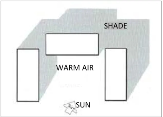
Dostoglu, 2007). Clustering should be the way of design for housing areas in order to trap warming air in courtyards (Fig.7).
Figure 7. Sample of design for trapping warm air in courtyards
The air circulation is essential for the climatic comfort in urban areas due to the ability of the wind to transfer exhaust gases, odours, sounds, heat and moisture from urban cores to the other parts of the city. Therefore, considerable attention should be given to ventilation aspects in the design process of settlements. Ventilation channels as a design element should enable cooler air flows from the surrounding lower density areas, green areas or water bodies towards the center as well as between the inner city green areas and densely populated areas (Milosovicova, 2010).
It is difficult to suggest the ideal or most efficient urban form for better ventilation and human physical comfort in cold climates. Protection from the north wind, by locating possibly in a south facing position, and locating high-rise buildings where needed, are the strategies for climate sensitive urban planning providing sufficient ventilation, preventing overradiation and heat release, and enhancing climatic comfort (Milosovicova, 2010).
Parks and Green Areas
Parks and green areas are tools in urban design for modifying the micro- climate of urban areas. While they can be used for the protection of buildings from winter winds, they may also be used for opening them to summer winds. Thus, the positioning of them is important for the control of wind direction and speed, and air temperatures around the buildings. While urban parks designed as enclosed shapes with deciduous planting can be a heat source in winter, they also provide shade in summer and are a good source of cooler air. On the other hand, they can be used for the modification of air quality and noise impact with the help of suitable planting (St.Clair, 2010).
As summarized by Milosovicova (2010, p.32), “the climatic effects of green areas in cities are in improving the air quality and urban climate through the retention, absorption and evapotranspiration of rainwater;
returning the rainwater in the form of vapour to the small water cycle;
reducing air pollution; reducing the noise impact by traffic, neighbours;
positively affecting natural urban ventilation; and providing urban areas with shade and lower temperatures in hot seasons”. At this point, the design and position of the green and built-up areas in the city become important. In
SUN
SHADE
WARM AIR
order to allow the penetration of cooling winds into the built-up areas, loose design of the urban edge is the solution (Milosovicova, 2010). In cold climate regions, the form and position of the green areas and plants should not be planned linearly with the cold wind. If it will be linear, it must be vertical to the direction of cold wind (Shaghaghi et al., 2011).
3. THE CASE OF ERZURUM
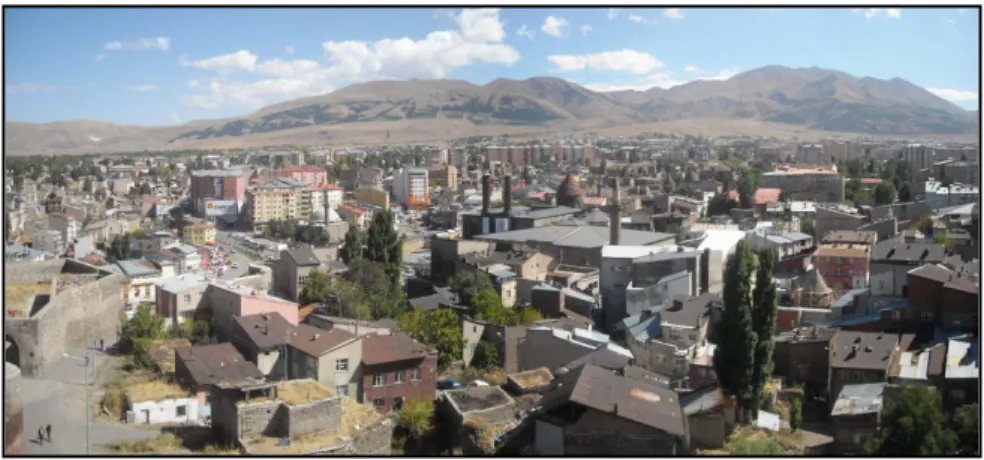
Figure 8. A View of the City of Erzurum
3.1. Climatic Specifications of Erzurum City
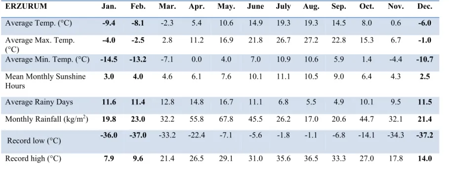
Erzurum is a city in eastern Turkey with nearly five hundred thousand people (urban population) and is the fourth largest city with an area of 25.066 km². As it is stated in the first section, it has a humid continental climate typified by large seasonal temperature differences with warm to hot summers and cold (sometimes severely cold) winters. While sunny days are at their minimum, snow is a major occurence. Average monthly temperature, snow and rainfall are as shown below (see Table I). This table simply shows the cold climate characteristics of the city. Erzurum is one of the coldest cities in Turkey with its very cold winter months having an average minimum during January of around 15 °C. The topographical structure and geographical position create this continental climate.
Winter months continuing for generally six months are rather cold, while the summer period generally is under the hegemony of a hot and arid climate.
The annual number of rainy days is 126 and number of snowy days is 50.
Snow cover duration is 114 days (Erzurum Valiligi, 2013). The differences between night and day temperatures are very high. In addition, the direction of the prevailing wind is southwest. Under these climatic conditions, some negative effects are observed in Erzurum, such as the short daytime, air pollution, temperature differences, icy road and pedestrian ways, and oblique angle of sunlight.
3.2. Analysis of the Three Districts: City Centre, Yenisehir (New City), Dadaskent
In this part of the study, three different districts of Erzurum city are analysed with factors deduced from the literature: density, floor area ratio, building coverage ratio, average height, sealed surface, H/W ratio, SVF, green areas and street orientation. These analyses are made with the aim of
proposing a set of climate sensitive design guidelines. For this reason, the existing urban structure is reviewed in this stage within this framework.
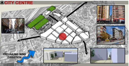
Figure 9. Existing situation of city centre (pictures and sketch-up simulations)
In the first part, the city centre is analysed due to the terrible winter conditions. In the winter months, due to the very narrow structure, it is almost not possible to pass across some of the streets in the city centre. Air pollution is the other important problem in this area (Fig. 9-10). Urban geometry as a climate related factor is analysed using the H/W ratio and sky view factor (SVF) with the aim of evaluating the existing situation of the built environment in the city centre. The H/W ratio is calculated as 4.2 in this area, demonstrating that it is a shallow street, and sunlight and radiation cannot reach the street ground or heat the air near the ground. On the other hand, the sky view factor is determined with the fisheye photograph taken in the selected street as 0.15 by using the RayMan module (Matzarakis et al.
2010). It shows that the ratio of sky visible at the middle of the street is 15%.
It can be said for the city centre of Erzurum that it has a deep street canyon form and absorption stays high above the ground level. If we use Emmanuel’s (2005) suggestion of the ideal value of an H/W ratio being an urban canyon with a ratio of 0.4-0.6, the city centre of Erzurum has a serious problem related to this ratio. The built environment decreases the solar access in the streets.
Another urban parameter, building volume, is analysed for this region.
They are seven floor multi-unit buildings covering all parts of the building blocks. It seems positive at first glance but there is no height difference or open places providing ventilation and solar radiation absorption. When the street orientations are analysed, it is observed that they are parallel to the prevailing wind direction. However, design and positioning of the high density built-up areas prevents winds entering the city center. Setbacks on the building surfaces, strategical location of few high-rise towers, bridge- buildings, corridors and green fingers have not been considered in the planning process. The configuration of streets determining airflow in urban areas is narrow and deep in the city centre, slowing airflow and causing air pollution. On the other hand, orientations nearly coincide with the south- north direction as the ideal form for the sunlight to reach, but density does not allow the sunlight in.
Table 1. Climate Data for Erzurum
Source: Turkish State Meteorological Service, 2013
ERZURUM Jan. Feb. Mar. Apr. May. June July Aug. Sep. Oct. Nov. Dec.
Average Temp. (°C) -9.4 -8.1 -2.3 5.4 10.6 14.9 19.3 19.3 14.5 8.0 0.6 -6.0 Average Max. Temp.
(°C)
-4.0 -2.5 2.8 11.2 16.9 21.8 26.7 27.2 22.8 15.3 6.7 -1.0
Average Min. Temp. (°C) -14.5 -13.2 -7.1 0.0 4.0 7.0 10.9 10.6 5.9 1.4 -4.4 -10.7 Mean Monthly Sunshine
Hours 3.0 4.0 4.6 6.1 7.6 10.1 11.1 10.5 9.0 6.4 4.3 2.5
Average Rainy Days 11.6 11.4 12.8 14.8 16.7 11.1 6.8 5.5 4.9 10.1 9.5 11.5 Monthly Rainfall (kg/m2) 19.8 23.0 32.2 55.8 67.8 45.5 26.2 17.0 20.6 44.7 32.1 21.4
Record low (°C)
-36.0 -37.0 -33.2 -22.4 -7.1 -5.6 -1.8 -1.1 -6.8 -14.1 -34.3 -37.2 Record high (°C) 7.9 9.6 21.4 26.5 29.1 31.0 35.6 36.5 33.3 27.0 17.8 14.0
Density as an important parameter of urban climate is measured in the city centre and it is identified as a very high density region with 990 dwellers/ha. High population density, which is more than 250 dwellers/ha, is the reason of high thermal loads in this urban area. Its surfaces are one hundred percent sealed and there are no green areas, causing higher heat load and polluted air. The rate of cooling at night is slow due to the absorbed heat on sealed and multistorey building surfaces. In support of this, floor area ratio is calculated as 4.2 in the city centre. High urban density and compact urban form in the city centre can be considered as positive due to the effects on the climatic comfort with the low ratio of settlement areas and road infrastructure.
With the help of short walking and driving distances, transportation problems are decreased. However, the length of the shadow cast by buildings over other buildings located opposite prevents solar access to other buildings.
Givoni’s (1998) suggestion for the building design as two-to-three storey buildings oriented towards the south can be considered for this region of the city.
Land use and settlement patterns of the region are the other urban parameters analysed for the city centre. As the land use pattern and green areas are determined, it is observed that there are no green areas in the city centre (Fig.13). Air circulation as the essential feature of climatic comfort in urban areas can be provided by green areas. They transfer exhaust gases, sounds, heat and moisture from urban cores to the other parts of the city.
Therefore, ventilation aspects of the design process of settlements should be considered at the first stages of planning with green areas especially in the city centre. When the settlement pattern is analysed (Fig. 15), high density spontaneous development can be observed. Land use mixing is the strategy can be used for this part of the city. Togetherness of office buildings, houses and stores with appropriate vertical and horizontal separation can be the solution for the climatic comfort in the city centre.
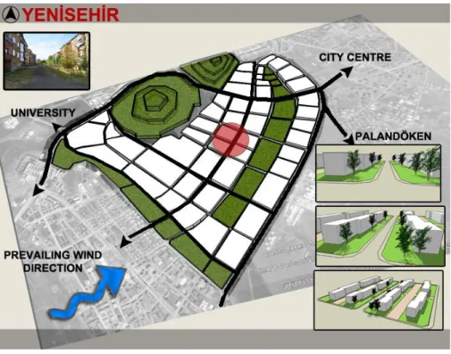
Figure 11. Existing situation of New City (picture and sketch-up simulations)
Figure 10. Analysis of City Centre, Yenisehir and Dadaskent (SVF, H/W, street orientation, physical analysis, etc.)
In the second part, Yenisehir (New City) is analysed because of its more organized structure. (Fig. 10-11). As an important urban parameter, geometry is analysed with the H/W ratio and SVF. The H/W ratio is calculated as 0.5 in this area. Sunlight and radiation are able to reach the street ground and heat the air near the ground. On the other hand, the sky view factor is measured as 0.42 by using the RayMan module. It shows that the ratio of sky visible at the middle of the street is 42%. It can be said for the New City of Erzurum that its urban canyon has an ideal H/W ratio of 0.4-0.6. The built environment increases the solar access in the streets.
Building volume as the other urban parameter is analysed for this region.
There are five-floor buildings covering limited parts of the building blocks.
This is positive for climate sensitive consideration, but there are no height differences providing ventilation and blocking undesired cold winds. Open places as positive design elements leading solar radiation absorption are considered in this part of the city. When the street orientations are analysed, it is observed that they are parallel to the prevailing wind direction. As it is emphasized in the literature, they should be planned as perpendicular to the cold winds. However, design and positioning of the high-rise buildings in some parts of the region can be a strategy for blocking cold winds. The configuration of streets has been made as wide providing an increase in the speed of the airflow. On the other hand, orientations of the buildings have been planned consistent with the south-north direction providing sunlight.
Density as the second urban parameter influencing climate is measured in the New City. It is a high density region with 296 dwellers/ha. As Milosovicova stated (2010), high population density is the reason for high thermal loads in urban area. It has twenty-three percent sealed surfaces and seventy-seven percent green areas, decreasing higher heat loads and air pollution. The rate of cooling at night is high due to the absorbed heat on green areas. The floor area ratio is calculated as 1 in the New City. Urban form in this part of Erzurum is linear starting from east and developing toward a south-west direction. It is not in compact form. While the high urban density and linear urban form in the New City can be evaluated as negative due to the effects on the climatic comfort, low building coverage ratio (0.2) and sealed surfaces are positive aspects. The length of the buildings and the width among them does not cast a shadow over the other buildings. Therefore, it allows solar access to other buildings. However, as Givoni (1998) suggested, two-to-three storey buildings oriented towards the south are the ideal conditions, so lower buildings should be designed in this region.
Land use and settlement pattern are the last urban parameters analysed for the New City, showing different characteristics. Green areas are analysed and it is observed that there are many green areas in this region of Erzurum (Fig. 13). The air circulation as an essential feature of climatic comfort is provided by these green areas. There is no ventilation problem in terms of the transfer of gases, odours and noises from this region to other parts of the city space. When the settlement pattern is analysed (Fig. 15), high density and organized development can be observed.
In the third example, Dadaskent is analysed because it is the satellite settlement in Erzurum causing urban sprawl and effecting urban climate.
Although, there is no need to settle in distant places. Dadaskent is located in the west part of the city with a rent based approach. It is a place having a high ground water level on the Erzurum plain. All climate and design based factors are analysed for this region (Fig. 10-12). Urban geometry as a
climate related factor is analysed with the H/W ratio and sky view factor.
The H/W ratio is calculated as 0.75 in this area, demonstrating that it is a uniform street. It allows sunlight and radiation to reach the street ground and heat the air near the ground. On the other hand, the sky view factor is determined with the RayMan module as 0.54 (Matzarakis et al. 2010). It shows that the ratio of sky visible from the middle of the street is 54%. It can be said for Dadaskent that its urban canyon exceeds the ideal H/W ratio of 0.4-0.6. The built environment decreases the solar access in the streets.
Figure 12. Existing situation of Dadaskent (sketch-up simulations)
Another urban parameter, building volume, is analysed for this region.
There are five-floor buildings covering limited parts of the building blocks.
It is positive for climate sensitive considerations, but there are no height differences providing ventilation and blocking undesired cold winds. Open places in the Dadaskent area allow solar radiation absorption. Street orientation analyses showed that they are parallel to the prevailing wind direction. Setbacks on the building surfaces, strategical location of few high- rise towers, bridge-buildings, corridors and green fingers have not been considered in the planning process. On the other hand, orientations of the buildings have not been planned consistent with the south-north direction, providing sunlight.
Density as a parameter of urban climate is measured in Dadaskent and seen that it is a high density region with 253 dwellers/ha. High population density, which is more than 250 dwellers, is the cause of high thermal loads in this urban area. It has thirty percent sealed surfaces and seventy percent green areas, decreasing higher heat loads and air pollution. The rate of cooling at night is high due to the absorbed heat by green areas. The floor area ratio is calculated as 1.5 in Dadaskent. The high urban density and compact urban form of Dadaskent can be considered as positive due to the effects on the climatic comfort with a low ratio of settlement areas and road infrastructure, however, this increases driving distances, creates transportation problems and causes urban sprawl. So, Dadaskent cannot be evaluated as a positive development in the cold climate city of Erzurum. As Givoni (1998) suggested, two-to-three storey buildings oriented towards the south are the ideal solution for climate sensitive design, but it is not considered in this region.
When the land use of the region is analysed, it is observed that there are small and unorganized green areas in Dadaskent (Fig. 13). The settlement pattern (Fig. 15) shows high density and planned characteristics.
Figure 13. Green areas in Erzurum
4. URBAN DESIGN STRATEGIES
In this part of the study the urban design solutions for the city of Erzurum from a climate sensitive perspective will be summarized. In cold climate regions, selection of suitable places for urbanization is the first important point. Sites promoting solar radiation and reducing the effects of winter wind must be selected. South facing slopes are ideal places for settlements in terms of maximizing available solar radiation. On the building scale, dense layouts, referring to a group of larger building units, is the solution for the minimization of heat loss. A seperation of building becomes important for this type of urban design because minimization of shading by adjacent buildings in winter months is needed. As it is stated by St. Clair (2010, p.11),
“the distance between buildings in the north-south direction should be based upon a height to width ratio of 1:1.5. This represents a winter midday solar angle of 30º”. Streets and alleys should be designed with an average width to avoid creating wind tunnels. They must be planned as vertical to the direction of the prevailing cold winds. Many alleys can be designed nonlinear and curved in form to prevent the creation of wind tunnels (Shaghaghi et al., 2011).
For the better positioning of buildings in cold climate, they should be positioned in an urban area with an angle of 12.5 degrees towards the south- east, providing better absorption of sunlight on winter days (Fig. 14).
Figure 14. Building direction towards the sun (St. Clair, 2010, p.16)
The urban fabric should be in a compact form and the buildings should be constructed with a low area in front. Multi storey buildings are the solution for cold climate regions at a micro scale. Use of varied height buildings from north to south consisting of multi-storey buildings, medium density, row houses and villas minimises the penetration and speed of winds in winter (Givoni 1998). South facing clustering and the use of central yards are the other microscale solutions that can be considered in Erzurum. This would provide the ability to trap warm air in courtyards between buildings.
Courtyards protect outdoor spaces against winds, maximise solar access and minimise shading in winter whilst opening to breezes in summer, maximising shading vegetation and minimising solar access to vertical and horizontal surfaces in summer (St. Clair, 2010). Use of underground floors can also be considered due to the ability of decreasing the thermal surfaces of the buildings (Shaghaghi etal., 2011). Outdoor space should be directed towards the south side in order to maximise solar exposure in winter.
Additionally, connection of outdoor space to existing buildings must be provided with the aim of promoting urban ventilation and thermal comfort.
Street widths, orientations and pedestrian pathways as tools of urban design should be considered in climate sensitive urban planning. Streets must be oriented perpendicular to the prevailing winter winds to reduce discomfort and temperature loss. On the other hand, streets must be oriented parallel or at 30-45 degree angles to the prevailing summer winds (Givoni 1998, p.439).
Bridges between buildings can be considered in order to reduce the wind speed in the street. Use of thick walls on the side of the building facing cold winds reduces heat loss and provides thermal insulation (Shaghaghi et al., 2011). For the volume of buildings, cube forms must be selected because to provide maximum interior volume against minimum exterior surface.
In addition to the built-up areas, green areas in the urban space must be considered as an important climate sensitive design element. Green fingers connecting new vegetation to existing parks should be designed to promote cooling (Givoni, 1998). Urban parks must be designed with deciduous planting in enclosed forms so as to keep the heat in winter and to provide shade in summer (St. Clair, 2010). Pine (trees) can be trialled in those parks as they never lose their leaves in winter (Shaghaghi et al., 2011).
Figure 15. Settlement Patterns of Selected Districts
5. CONCLUSION
As seen in the analysis, urbanization in Erzurum has not followed climate sensitive processes. In fact, it can be redesigned as a winter city by focusing on the positive aspects of winter such as outdoor recreational activities, indoor art, culture and social activities, winter tourism and festivals.
However, there is no awareness of the positive aspects and way of coping with the winter in Erzurum at both municipal and grassroot levels. Climate sensitive strategies can be used for the districts of Erzurum to protect them from the terrible cold weather in winter and reduce the need for artificial heating and cooling. Use of the suggested strategies will be a solution for air pollution and other design based problems and can be a guide for a new part of the city. In this process, it should always be remembered that climate sensitive design is a complicated process in urban planning, including different scale interventions depending on the land uses in the urban area, such as built-up or green areas, water surface and industrial areas.
On the other hand, hybrid strategies that address both summer and winter conditions should be considered or the weight should be on winter strategies and heat conservation in Erzurum. The key strategies should be based on the
“protection against winter winds, maximising solar radiation gain, the use of insulation and the provision of a concentrated plan” (St. Clair, 2010, p.9).
Erzurum’s high summer temperatures and cold winters need adaptable strategies of site and building design. Compact and open planning suggested by Givoni may be useful in this climate type (1998).
All these climate related urbanization and environmental issues must urgently be included into the urban planning process of Erzurum. Otherwise, environmental crises will be the most critical issue in the near future.
Inappropriate settlement areas, poor urban design and planning activities and an increasing number of automobiles are the major contributors to environmental damage. As can be observed from data (TUİK, 2013, Number of Road Motor Vehicle by Provinces), the city of Erzurum have both planning and planning led transportation problems. In the process of time, it can be clearly observed that all of the urbanization practices in Erzurum will further increase ecological damage.
Therefore, this study should be accepted as the very first stage of the climate related studies in Erzurum. Possible urban design strategies for cold climate regions are summarized in this study, but climatic map studies are still missing for Erzurum. In the following stages of this study, climatic map studies should be done. Both this and climatic map studies will be essential inputs for the urban planners in Erzurum and other cold cities in Turkey.
REFERENCES
Basibuyuk, A. (2005). "Dogu Anadolu Bolgesinde Ortalama Hanehalki Buyukluklerinin Dagilimi". Eastern Geographical Review, 10(13), s. 273-289.
Caliskan, O. (2012). "Turkiye'nin Biyoklimatik Kosullarinin Analizi ve Sehirlesmenin Biyoklimatik Kosullara Etkisinin Ankara Olceginde Incelenmesi". Doktora Tezi. Ankara:
Ankara Universitesi Sosyal Bilimler Enstitusu.
Caliskan, O., & Matzarakis, A. (2013). "The Climate and Bioclimate of Nevsehir from the Perspective of Tourism. Advances in Meteorology", Climatology and Atmospheric Physics Springer Atmospheric Sciences, 397-402.
Caliskan, O., Cicek, I., & Matzarakis, A. (2011). "The Climate and Bioclimate of Bursa (Turkey) From the Perspective of Tourism". Springer, s. 417-425.
Ebrahimabadi, S., Johansson, C., Nilsson, K.L., (2012). "The challenges of incorporating climate considerations into urban planning of the subarctic regions", Paper I). (Submitted for publication in European Planning Studies in May 2012
Emmanuel, R., (2005), "An Urban Approach to Climate-Sensitive Design – Strategies for the Tropics", Spon Press, New York
Ercoskun, O. Y. (2007). "Surdurulebilir Kent Icin Ekolojik-Teknolojik (Eko-Tek) Tasarim:
Ankara-Gudul Ornegi". Doktora Tezi. Ankara: Gazi Universitesi Fen Bilimleri Enstitusu.
Erzurum Buyuksehir Belediyesi. (2012). "Koruma Amacli Imar Plani" Arastima Raporu.
Erzurum.
Erzurum Valiliği, "Cografi Yapı", www.erzurum.gov.tr., 19 July 2013.
Gehl, J., (1996), "Life between buildings, Copenhagen": Arkitektens forlag.
Girginer, S. (2006). "Kentsel Tasarim ile Ekolojik Surdurulebilirligin Iliskilendirilmesi ve Toplu Konut Gelisme Bolgelerinde Orneklenmesi". Yuksek Lisans Tezi. Izmir: Dokuz Eylul Universitesi Fen Bilimleri Enstitusu.
Givoni, B., (1998), "Climate Considerations in Building and Urban Design", John Wiley &
Sons, Inc., NY
Guclu, K. (1988). "Erzurum Kentinin Yesil Alanlarinda Planlama ve Uygulama Sorunu".
Ataturk Universitesi Ziraat Fakultesi Dergisi, 19(1-4), 51-63.
Gulten, A. (2007). "Kent Dokusunda Gunes Isinimindan Yararlanmak Icin Cadde-Bina Iliskisinin Arastirilmasi". Yuksek Lisans Tezi. Elazig: Firat Universitesi Fen Bilimleri Enstitusu.
Gulten, A., & Aksoy, T. (2010). "Gokyuzu Gorus Faktoru ve Bina Yuzey Sicakliklarina Bagli Olarak Cadde Geometrisi-Gunes Isinimi Etkisi". Firat Universitesi Muhendislik Bilimleri Dergisi, 22(2), 157-170.
Herrmann, J., Matzarakis, A., (2010), "Influence of mean radiant temperature on thermal comfort of humans in idealized urban environments". In: Matzarakis, A., Mayer, H., Chmielewski, F.-M. (Eds.), Proceedings of the 7th Conference on Biometeorology. Ber.
Meteorol. Inst. Univ. Freiburg No. 20, 523-528.
Hisarligil, H. (2009). "Enerji Etkin Planlamada Konut Adasi Tasarimi: Hipotetik Konut Adalarinin Ankara Orneginde Mikroklima Analizi". Doktora Tezi. Ankara: Gazi Universitesi Fen Bilimleri Enstitusu.
Koseoglu, B. (2012). "Kentsel Kamusal Mekanlarin Iklim Duyarli Tasarlanmasi: Turkiye Orneklerinin Karsilastirilmasi". Yuksek Lisans Tezi. Ankara: Gazi Universitesi Fen Bilimleri Enstitusu.
Kottek, M., J. Grieser, C. Beck, B. Rudolf, and F. Rubel, (2006). "HYPERLINK
"http://koeppen-geiger.vu-wien.ac.at/pdf/Paper_2006.pdf" \t "_blank"
World Map of the Köppen-Geiger climate classification”, updated . Meteorol. Z., 15, 259- 263
Kuscu, C. (2010). "Landsat Tm Verileri Uzerinden Yuzey Sicakligi Haritasinin Olusturulmasi ve Yersel Olcumler ile Iliskisinin Incelenmesi". I. Ulusal Planlamada Sayısal Modeller (s.
423-436). Istanbul: Istanbul Teknik Universitesi.
Matzarakis A, Rutz F, Mayer H., (2010), "Modeling radiation fluxes in simple and complex environments − basics of the RayMan model". Int J Biometeorol 54:131-139
Milosovicova, J., (2010), "Climate-Sensitive Urban Design in Moderate Climate Zone:
Responding to Future Heat Waves Case Study Berlin – Heidestrasse/Europacity", Master Thesis in Urban Design, Downloaded from http://jm-urbandesign.com/csud_thesis.html, on 11 July 2013)
Pressman, N. (1985). Reshaping winter cities: Concepts, strategies and trends. Waterloo, Ont.: Published under the auspices of Livable Winter City Association by University of Waterloo Press.
Pressman, N. (1995). Northern cityscape: Linking design to climate. Yellowknife, N.W.T.:
Winter Cities Association.
Pressman, N. (2004). Shaping cities for winter: Climatic comfort and sustainable design.
Prince George, B.C.: Winter Cities Association.
Piringer, M. and Joffrey, S., (2004), "The Urban Surface Energy Budget and Mixing Height in European Cities: Data, Models and Challenges for Urban Meterology and Air Quality", Final Report of Working Group 2 of COST-715 Action
Sahin, E., & Dostoglu, N. (2007). "Kentsel Mekan Tasarımında Doğal Verilerin Kullanımı".
Uludag Universitesi Muhendislik-Mimarlık Fakultesi Dergisi, 12(1), 29-40.
Shishegar, N., (2013), "Street Design and Urban Microclimate: Analyzing the Effects of Street Geometry and Orientation on Airflow and Solar Access in Urban Canyons", Journal of Clean Energy Technologies, Vol. 1, No. 1, January
Simsek, C. K., & Sengezer, B. (2012). "Istanbul Metropoliten Alaninda Kentsel Isinmanin Azaltilmasinda Yesil Alanlarin Onemi". Megaron Article, 7(2), 116-128.
Soysal, S. (2008). "Konut Binalarinda Tasarim Parametreleri ile Enerji Tuketimi Iliskisi".
Yuksek Lisans Tezi. Ankara: Gazi Universitesi Fen Bilimleri Enstitusu.
St.Clair, P., (2010), "Guidelines for Climate Responsive Design in Cold Climates with Particular Reference To Beijing, China".
TUIK. (2011). Secilmis Gostergelerle Erzurum. Ankara.
TUIK. (2013). Number of Road Motor Vehicle by Provinces. Ankara.
Zengin, M., Oguz, H., & Ozer, S. (2009). "Kentsel Acik-Yesil Alanlarin Zamana Bagli Alansal Degisimlerinin Belirlenmesi: Erzurum Palandoken Ilcesi Yenisehir/Yildizkent Yerlesim Alanlari Ornegi". 3. DEU CBS Sempozyumu. Izmir.