Oceanic Conditions in the Western Tropical
Pacific in the Summer of 1988
著者
YUWAKI Yasutaka, NISHI Toru, MASUMITSU Sunao,
HIGASHI Masataka
journal or
publication title
鹿児島大学水産学部紀要=Memoirs of Faculty of
Fisheries Kagoshima University
volume
37
page range
97-109
別言語のタイトル
1988年夏期 西部熱帯太平洋に於ける海況
Mem. Fac. Fish. Kagoshima Univ., Vol. 37,pp. 97-109 (1988)
Oceanic Conditions in the Western
Tropical Pacific in the Summer of 1988
Yasutaka Yuwaki*, Toru Nishi*, Sunao Masumitsu*, and Masataka Higashi*
Keywords : Oceanic condition, Western Tropical Pacific, Equatorial Current
AbstractOceanographic observations using a CTD system were made in the Western Tropical Pacific in the summer of 1988.
The first oceanographic section was made along 133°E from 20°N to 10°N from June 13-18th, and the second onefrom 09°N, 138°E to 00°, 149°E from June 25-28th. The warm surface water having a value of above 291C was presented over the whole sea surface. The thermocline with the maximum vertical gradient having a value of0.17*0 /m was the shallowest near 09°N. The low salinity lower than 34.50%o was presented in the surface mixed layer between 16°N and 02°N.
The conspicuous transitions were formed on each side of the north and south of the low salinity
water.
The North Equatorial Current was recognized on the north side of 08°N ;the South Equatorial Current near the Equator ; and the North Equatorial Countercurrent inthe region between 08°N and 01°N. Several step-like features and inversion layers were presented in the thermocline at the Equator. The lateral advection of water masses in the surface layer was well developed near
the Equator.
Introduction
It is well known that the regions of the North Equatorial Current (NEC) and the North
Equatorial Countercurrent(NECC) in the Western Pacific Ocean are abundant in fishes
such as tuna, especially yellowfin and bigeye tunas.
The oceanic environment of tuna and skipjack fishing grounds have beenstudied by many
oceanographers ; Nakamura et al. (1959)1), Kamimura et al. (1963)2), Yamanaka et
al. (1965)3), Suda(1969)4) and Hanamoto(1974)5).
Besides the fishing grounds, these workers had a great interest in the earth's climate,
particularly associated with the El Nino Southern Oscillation (ENSO) events. In recent
years, the necessity arose to accumulate oceanographic data for monitoring of the oceanic
conditions in the Western Tropical Pacific, as described by Delcroix et al. (1987).
In relation to the two subjects mentioned above, the oceanographic observations were * Training Ship Keiten Maru, Faculty of Fisheries, Kagoshima University, 4-50-20 Shimoarata,
98 Mem. Fac. Fish. Kagoshima Univ., Vol. 37 (1988)
carried out by the Keiten Maru in June, 1988.
This work describes the analysis of temperature, salinity, dynamic height and the water masses in the Western Tropical Pacific.
Oceanographic Observations
The Keiten Maru (860 tons), fishery training and research ship of the Kagoshima University, carried out the cruise for cadets training between Kagoshima, Japan and Honiara, the Solomoms via Yap, the West Caroline Islands, the Federated States of Micronesia from 10 June to 18 July, 1988.
As shown in Fig. 1 on her cruise from Kagoshima to Yap, the first oceanographic section
was made along 133°E, starting with Stn. 1 at 20°N on 13th June and ending with Stn. 8 at 10°N on 18th June(Section A) ; after leaving Yap, the second one was made from Stn. 9 at
9°N, 138°E on 25th June to Stn. 18 at the 00°, 149°E on 28th June (Section B). The distance
between adjacent stations was about 90 miles. The data of oceanographic observations were
obtained by a CTD( Conductivity, Temperature and Depth Meters) system (Neil Brown Model 1150) and recorded on magnetic tape, and printed on recording paper. The sensor of
CTD was cast down from the surface to 1,200 db with a lowering speed of ca. 60 m/min.
Results and Discussion
Temperature Section
Distributions of water temperature in Sections A and B are shown in Fig. 2(a) and (b). In Fig. 2(a), the warm surface water having a value of above 29°C was presented over the whole sea surface in the surface mixed layer ; the highest temperature was 29.68°C at Stn. 3. The isotherm of 29°C descended from the north to the south, the depthsof which were
ca. 20m at Stn. 2 and ca. 60m at Stn. 7.
In the subsurface layer, the isotherms from 27 to 12°C, which corresponded to the thermocline, descended towards the north and a sharp slope was presented in the region
between Stns. 6 and 7. The depth of thermocline was the shallowest near Stn. 7(12°N) at the depth between 100-200m, and the vertical gradient of temperature in the thermocline was
ca.0.10°C/m.
The isotherms in the thermocline were spreading from Stn. 7 to the north.
The downward slopes of the thermocline from Stn. 7 to the north and to the south were
associated with the NEC and the NECC.
At the time of this cruise, the boundary between the NEC and the NECC was recognized
to be located near 12°N of the northern region of Yap Islands.
Below the depth of 800m, the isotherms of 5 and 4°C descended from the north to the
south, which was the opposite condition to the thermocline distribution with latitude. In Fig. 2(b), the warm surface water having a value of above 29°C was presented over the whole sea surface in the surface mixed layer and the value of highest temperature was 30.28°C at Stn. 12(6°N). The isotherm of 29°C showed a smoothly concave pattern, and the
Yuwaki et al. '• Oceanic Conditions in the Western Tropical Pacific 30°N -KYUSYU OKINAWA 20°N 10°N 00° 10°S -1 A 2 A 3 A 4A 5 A 6A 7A 8 0 GUAM I.
A YAP I WEST CAROLINE Is.
/Ai'
•
10 A ' * 11 A 12 A 13 A 15 A 16 A 17 A 18130°E 140°E 150°E
99
160°E
Fig. 1. Map showing the locations of CTD observations carried outalong 133°E from 20°N to 10°N (Secion A), and the region between 09°N, 138°E and 00°, 149°E(Section B).
100 Mem. Fac. Fish. Kagoshima Univ. , Vol. 37 (1988) STATION NUMBERS 12 3 4 5 6 7 8 200 CO ^ 400 LU h-LU 600 CL LU Q 800 -1000 1200 20°N 16°N 12°N STATION NUMBERS 9 10 12 14 16 18 200 co
S 400
LU ^ 600 Q_ UJ Q 800 " 1000 1200 -8°N 4°N 00°Fig. 2 Distributions of water temperature (°C ) on the Sections A (a) and B(b).
maximum depth was ca. 75m in the region between Stns. 11 and 15. The upwelling was not found at the Equator.
In the subsurface layer, the thermocline descended slightly from 8°N to the Equator. The vertical gradientof temperature in the thermocline was ca. 0.17°C/m at Stn. 13, showing the largest value in the whole region. The thermocline spreading at the Equator was apparently existent, indicating that the Equatorial Undercurrent(EUC) did exist. The thermocline descended from the north to the south, in association with the NECC. The Equatorial
Countercurrent ridge of the thermocline was located in the boundary(8°N) between the NEC
and the NECC. The ridge in this section was located ca. 240 miles on the south side of that
Yuwaki et al. '. Oceanic Conditions in the Western Tropical Pacific STATION NUMBERS 1 2 3 4 5 6 7 8 1200 STATION NUMBERS 9101112 14 16 18 -34.70 -35.30 20°N 16°N 12°N 8°N 4°N 00°
Fig. 3 Vertical distributions of salinity (%o) on Sections A(a) and B(b).
101
Salinity Section
Vertical distributions of salinity in Sections A and B are shown in Fig. 3(a) and (b). In Fig. 3(a), the surface salinity water lower than 34.00%o was presented in the surface mixed layer near Stn. 7(12°N), in association with the boundary between the NEC and the
NECC. The isohaline of 34.50%o was seen in the center between the low salinity surface water and the subsurface saline water extending from the north, and reached to the sea
surface at Stn. 4.
In the subsurface layer, the saline water higher than 34.90%o extended from the north to the south at a depth between ca. 150-300 m. The depth ofthe highest salinity water higher than 34.90%o nearly coincided with that of isotherm of 22°C. Below the subsurface layer, the Intermediate Water lower than ca. 34.40%o ascended towards the south and its core was presented at a depth between ca.550 and 700m at Stn.1, and ca.400m at Stn. 6.
In Fig.3(b), the surface water lower than 34.00%o was presented in the surface mixed layer, the depths ofwhich were ca. 25m near Stn. 10 and ca. 60m at Stn. 14. The isohaline of 34. 00%o reached to the sea surface near Stn. 16. The minimum value of the salinity was
102 Mem. Fac. Fish. Kagoshima Univ., Vol. 37 (1988)
salinity front) was presented between the low salinity surface water and the high salinity
tongue ofwater originating in the center oftheSouthPacificSubtropical Gyre as seenin the seasurface between Stns. 16(2°N) and 18(Equator). The edge ofthe high salinity tongue of the North Pacific was presented at a depth ofca. 150 mat Stn.9. Therelatively low salinity
region between the high salinity tongues extending from the north and the south was
associated with the NECC.
Below the subsurface layer, the salinity amounted to 34.50-34.60%o in the whole water column to 1,200m. The low salinity tongue of the North Pacific Intermediate Water was not
clearlyfound, but the edgeof its salinitytongue reached the depth of ca. 200 m at 03°-30'N.
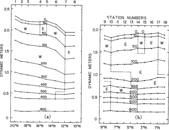
Dynamic Height Section
Dynamic height section referred to 1,000 db in Sections A and B are shown in Fig. 4(a)
and (b), in order to understand the zonal current.
In Fig. 4(a), the equi-geopotential surface mostly declined from the north to Stn. 7(12°N), which is associated with the NEC. Between Stns. 7 and 8, the eastward current
was the NECC.
In Fig. 4(b), the relatively complicated zonal current structure can be seen. The larger part of the eastward current was associated with the NECC. At the Equator, a very weak
STATION NUMBERS 1 2 3 4 5 6 ~T 20°N 18°N 16°N STATION NUMBERS 9 10 11 12 13 14 15 16 17 18
Yuwaki et al. '. Oceanic Conditions in the Western Tropical Pacific 103
eastward current was recognized below the surface westward current. If the eastward current at the Equator was the Equatorial Undercurrent(EUC), the NECC might be connected to the EUC by continuous eastward current.
This zonal current structure had often been observed in the Western Tropical Pacific (Delcroix et al.,1987)6).
The westward current near the Equator in the surface layer was recognized as the South
Equatorial Current(SEC).
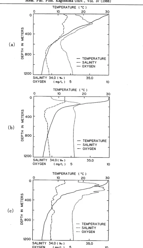
Upper Water Oceanic Structure
Upper water oceanic structure seemed to be related to the tuna fishing ground and the
air-sea boundary process.For this purpose, the profiles of temperature, salinity and dissolved oxygen above 600 m
were examined.
In Fig. 5(a), (b) and (c), the profiles of temperature, salinity and dissolved oxygen are shown as records obtained by a CTD at Stns. 3(18°N), 12(6°N)and 18(Equator), respec
tively.
The profiles at Stn. 3 (Fig. 5, a) in the NEC showed that the thin mixed surface layer and the relatively thin subsurface salinity maximum with small spike-like features above ca. 200m, and the subsurface oxygen minimum exists at the salinity maximum. The profiles at Stn. 12 (Fig. 5, b) in the NECC showed that the mixed surface layer was well developed,
and then the approximately two layer ocean exists (Wyrtki et al., 1967)7) in the subsurface
salinity maximum in the center of the thermocline, and the subsurface oxygen minimum exists at a depth of ca. 200m below the salinity maximum water. The profiles at Stn. 18 (Fig. 5,c) at the Equator showed that several step-like features and inversion layers exist in
the thermocline and the thick salinity maximum withseveral large inversion layers indicates
active mixing near the Equator and lateral advection with salinity transport from the South Pacific. These conspicuous salinity inversions were found at 3°N, and the subsurface
oxygen minimum at the layer of the salinity maximum.
Temperature-Salinity (T-S) diagrams at the same stations as referred to in Fig. 5 are
shown in Fig. 6(a), (b) and (c), respectively. The T-S diagrams at Stns. 3 (Fig. 6, a) and
12(Fig. 6,b) showed numerous small step-like and inversion features above 15°C On the other hand, the T-S diagram at the Equator(Fig. 6,c) also showed several large step-like
and inversion features above 15°C. McPhaden(1985) indicated using about 40 d (potential
temperature )-S diagrams at 00°, 150°W that lateral advection ofdifferent water masses in the
thermocline and air-sea bouyancy fluxes at the surface existed at the Equator.
The upper water oceanic structure will be discussed in detail in another paper.
Summary
Based on the CTD data obtained by the Keiten Maru in the summer of 1988, the
oceanographic conditions in the Western Tropical Pacific were summarized as follows : 1) The warm surface water having a value of above 29°C was presented in the surface mixed layer. The depth of the surface mixed layer in Section A was smaller than that in
104 Mem. Fac. Fish. Kagoshima Univ., Vol. 37 (1988) TEMPERATURE ( °C ) 0 10 20 30 0 i ^ *. i ^ < ^-SZ--X in / /<>'"" a:
>^y
/^T-£400 LU (/-• 2 /? f 2 r '' / /7 '« I / // / "V H Q- 800 Q \J A j \ \ \ \ — TEMPERATURE \ —- SALINITY i \ / \ \ — OXYGEN 1200 / ij i \ i (a) 2 SALINITY 34.0 ( %. ) OXYGEN ( mg/L ) 5 35.0 10 TEMPERATURE (°C ) 10 20 if) 400 (b) ^ ol 800 LU Q 1200 SALINITY 34.0 (*.) OXYGEN ( mg/L ) 5 — TEMPERATURE - - SALINITY — OXYGEN 35.0 10 TEMPERATURE ( °C ) 10 20 30 or £400 LU 2 (c) * P- 800 1200 I i SALINITY 34.0 ( %o) OXYGEN ( mg/L ) 5 • TEMPERATURE - SALINITY - OXYGEN 35.0 10Yuwaki et al. : Oceanic Conditions in the Western Tropical Pacific (a) (b) (c) SALINITY ( %*) 34.0 35.0 SALINITY ( %o ) 34.0 35.0 SALINITY ( % ) 34.0 35.0 105 Fig. 6 Temperature-Salinity(T-S) 18(Equator)(c).
106 Mem. Fac. Fish. Kagoshima Univ., Vol. 37 (1988) Section B.
2) The thermocline ascended from the north to the south, which was the shallowest near
09°N at a depth between ca.100-200m, and descended gradually towards the Equator. The largest vertical gradient of temperature in the thermocline was presented near 07°N having a
value of 0.17°C/m.
3) The low salinity water lower than 34.50%o was presented between 16°N and 02°N in the surface mixed layer. Theconspicuous transition zones were formed between thelow salinity
surface water and the higher salinity waters extending from the north and the south. The
edge of the high salinity tongue of the North Pacific was found at the depth of ca. 150m at 09°N and that of South Pacific at 03°N. The Intermediate Water lower than 34.340%o ascended towards the south, the protrusion of which reached to 13°N at the depth of ca. 400
m .
4) The North Equatorial Current was recognized in the surface layer at the north side of 08°N, the South Equatorial Current near the Equator and the North Equatorial
Countercur-rent between 08°N and 01°N.
5) Several large step-like features and inversion layers existed in the thermocline at the Equator. The mixing process and the lateral advection in the surface layer were well developed near the Equator. The oxygen minimum was found at the layer of the salinity maximum.
Acknowledgment
The authors wish toexpress their hearty thanks toDr. M. Chaen, the Faculty ofFisheries of Kagoshima University, for his kind guidance and encouragement.^
References
1 ) H. Nakamura and H. Yamanaka(1959) : Relation between the distribution of tunas and the ocean
structure. J. Oceanogr. Soc. Jap., 15 (3), 143-149.
2 ) T.Kimura and M. Honma(1963) : Distribution of the yellowfin tuna in the tuna longline fishing
grounds of the Pacific Ocean. Rep. Nankai Fish.Res. Lab., 17, 31-53.
3 ) H. Yamanaka et al. (1965) : Seasonal and Long-term Variations in Oceanographic Conditions in the Western North Pacific Ocean. Rep. Nankai Fish. Res. Lab., 22, 35-70.
4 ) A. Suda et al. (1969) : An indicative note on arole of permanent thermocline as a factor controlling
the longline fishing ground for bigeye tuna. Bull Far seas Fish.Res. Lab., 1, 99-114. 5) E. Hanamoto(1974) : Fishery Oceanography of Bigeye Tuna-I. Depth of Capture by Tuna
Longline Gear in the Eastern Tropical Pacific Ocean. Umi., 12(3), 128-136.
6 ) T.Delcroix, G. Eldin, and C. Henin(1987) : Upper Ocean Water Masses and Transports in the Western Tropical Pacific(165°E). J. Phys. Oceangr., 17, 2248-2262.
7 ) K. Wyrtki and R. Kendall(1967) : Transports ofthe Pacific Equatorial Countercurrent. J. Geophys.
Res., 72(8), 2073-2077.
8 ) M.J.Mc Phaden(1985) : Fine-Structure Variability Observed in CTD measurements from the Central Equatorial Pacific. J. Geophys. Res., 90, 11726-11740.
Yuwaki et al. I Oceanic Conditions in the Western Tropical Pacific 107
Appendix
Date 13 June 1988 14 June 1988 15 June 1988
Stn. 1 2 3
Lat. 2o°-oo:o N 19°-06:i N 18°-02:0 N
Long. i33°-oo:o E 132°-59:0 E 133°-00:4 E
Temp. CC) Sali. (%o) Temp. (10) Sali. (%o) Temp. CC) Sali. (%o)
0 29.55 34.580 29.44 34.841 29.68 34.767 10 29.56 34.703 29.44 34.842 29.67 34.768 20 29.52 34.712 29.33 34.824 29.60 34.766 30 29.14 34.772 28.48 34.786 28.86 34.827 50 28.00 34.794 27.52 34.859 27.52 34.883 75 27.57 34.882 27.16 34.967 26.94 34.930 100 26.83 34.903 26.48 35.011 25.88 34.939 150 24.56 35.036 24.13 35.166 23.74 35.072 200 22.40 35.167 21.28 35.148 22.00 35.197 250 19.08 35.038 18.84 35.028 18.71 35.021 300 17.56 34.948 16.84 34.892 16.42 34.855 400 13.90 34.677 13.72 34.668 13.29 34.621 500 10.55 34.436 10.26 34.422 10.11 34.439 600 8.01 34.335 7.35 34.309 7.45 34.353 700 6.34 34.380 6.01 34.383 6.14 34.426 800 5.49 34.474 5.18 34.469 5.43 34.545 900 4.70 34.529 4.53 34.547 4.53 34.569 1000 4.14 34.588 3.99 34.617 3.97 34.622 1200 3.39 34.619 3.14 | 34.680 3.27 34.689
Date 16 June 1988 17 June 1988 17 June 1988
Stn. 4 5 6
Lat. 16°-10:5 N 14°-59:9 N 13°-30:i N
Long. 132°-59:9 E 132°-59:8 E i33°-oo:o E
Temp, (t) Sali. (%o) Temp, (t) Sali. (%o) Temp. CC) Sali. (%o)
0 29.43 34.586 29.62 34.063 29.54 33.940 10 29.23 34.572 29.48 34.070 29.41 33.937 20 29.23 34.604 29.47 34.084 29.29 33.957 30 29.24 34.623 29.26 34.371 29.39 34.413 50 28.68 34.774 29.15 34.504 29.22 34.477 75 27.36 34.835 27.83 34.563 28.26 34.491 100 26.59 34.896 27.13 34.732 27.41 34.664 150 24.17 35.104 25.97 34.952 25.79 35.022 200 21.19 35.077 22.38 35.078 20.19 34.822 250 18.50 34.894 17.11 34.726 15.78 34.650 300 15.60 34.668 13.80 34.513 12.59 34.435 400 11.43 34.359 9.54 34.316 9.15 34.345 500 8.35 34.312 7.79 34.394 7.68 34.437 600 6.62 34.352 6.74 34.437 6.48 34.461 700 5.67 34.429 6.01 34.459 5.73 34.492 800 5.14 34.483 5.44 34.493 5.22 34.522 900 4.65 34.514 4.68 34.514 4.88 34. 537 1000 4.18 34.543 4.23 34.541 4.40 34.551 1200 3.49 34.576 3.51 34.571 3.68 34.579
108 Mem. Fac. Fish. Kagoshima Univ., Vol. 37 (1988)
Date 18 June 1988 18 June 1988 25 June 1988
Stn. 7 8 9
Lat. ll°-59:9 N io°-;34:2 N 08°-59:8 N
Long. 133°-(do:o E 134°- 177 E 138°-<14:0 E
Temp, (t) Sali. (%o) Temp. (t) Sali. (%o) Temp, (t) Sali. (%o)
0 29.45 33.885 29.39 34.097 29.13 33.969 10 29.39 33.893 29.37 34.105 29.14 33.980 20 29.40 33.897 29.34 34.099 29.14 33.993 30 29.41 33.915 29.25 34.160 29.14 34.000 50 29.46 34.029 28.47 34.375 29.05 34.079 75 28.61 34.338 27.72 34.444 27.63 34.357 100 27.05 34.461 26.31 34.808 26.36 34.619 150 19.73 34.843 21.92 34.937 19.29 34. 932 200 15.39 34.631 15.74 34.638 14.15 34.609 250 12.26 34.526 12.23 34.489 11.87 34.568 300 10.79 34.488 10.55 34.523 10.08 34.565 400 8.75 34.563 8.75 34.549 8.39 34.584 500 7.33 34.474 7.97 34.571 7.45 34.557 600 6.42 34.469 6.77 34.468 6.69 34.536 700 5.90 34.505 6.41 34.536 6.15 34.536 800 5.37 34.531 5.83 34.541 5.51 34.541 900 4.98 34.540 5.34 34.536 5.04 34.552 1000 4.61 34.555 4.87 34.540 4.51 34.564 1200 3.93 34.576 4.05 34.572 3.74 34.588
Date 25 June 1988 26 June 1988 26 June 1988
Stn. 10 11 12
Lat. 08°-oo:i N 07°-00:3 N 06°-00:0 N
Long. 139°-52:5 E 141°-02:i E 142°-10:8 E
Temp. CC) Sali. (%o) Temp, (t) Sali. (%o) Temp, (t) Sali. (%o)
0 29.09 33.872 29.48 33.862 30.28 33.978 10 29.02 33.852 29.50 33.883 30.02 33.970 20 29.07 33.979 29.49 33.995 29.71 33.964 30 29.05 34.000 29.50 34.021 29.70 33.981 50 28.77 34.267 29.52 34.079 29.66 33.985 75 27.93 34.375 28.90 34.301 29.54 34.096 100 24.78 34.650 27.25 34.474 27.86 34.380 150 16.78 34.677 17.63 34.686 19.45 34.721 200 12.52 34.565 12.91 34.567 13.83 34.592 250 10.76 34.557 11.06 34.555 10.70 34.557 300 10.09 34.580 9.85 34.588 9.42 34.592 400 8.78 34.606 8.43 34.597 8.21 34.605 500 7.67 34.568 7.41 34.562 7.41 34.582 600 6.89 34.547 6.79 34.557 6.66 34.563 700 6.38 34.549 6.23 34.549 6.08 34.555 800 5.92 34.549 5.49 34.547 5.48 34.555 900 5.29 34.551 4.97 34.556 4.94 34.560 1000 4.77 34.561 4.42 34.570 4.52 34.568 1200 3.82 34.588 3.59 34.595 3.88 34.586
Yuwaki et al. I Oceanic Conditions in the Western Tropical Pacific 109
Date 26 June 1988 27 June 1988 27 June 1988
Stn. 13 14 15
Lat. 04°-59:9 N 04°-00:i N 02°-59:9 N
Long. 143°-13:9 E 144°-24:i E 145°-30:0 E
Temp, (t) Sali. (%o) Temp, (t) Sali. (%o) Temp. CC) Sali. (%o)
0 29.84 33.840 29.67 33.809 30.08 33.697 10 29.63 33.829 29.78 33.922 29.79 33.937 20 29.53 33.817 29.73 33.921 29.74 33.934 30 29.59 33.879 29.74 33.933 29.71 33.931 50 29.65 33.970 29.72 33.935 29.81 34.176 75 29.38 34.172 29.68 34.114 29.70 34.587 100 27.87 34.347 27.81 34.419 26.59 34.408 150 21.62 34.708 22.63 34.740 23.27 34. 763 200 12.25 34.540 14.15 34. 571 14.68 34.609 250 9.77 34.558 10.98 34.603 11.08 34.608 300 8.80 34.600 9.18 34.575 9.39 34.578 400 7.84 34.597 8.07 34.601 8.61 34.634 500 7.23 34.578 7.08 34.565 7.50 34.577 600 6.60 34.563 6.31 34.556 6.56 34.558 700 5.87 34.556 5.72 34.554 5.84 34.550 800 5.19 34.558 5.18 34.559 5.26 34. 555 900 4.72 34.566 4.66 34.568 4.49 34.569 1000 4.33 34.576 4.29 34.578 3.98 34.583 1200 3.71 34.592 3.54 34.599 3.41 34.602
Date 27 June 1988 28 June 1988 28 June 1988
Stn. 16 17 18
Lat. 01°-J59:8 N 00°-59:9 N oo°-oo:i N
Long. 146°- 39:i E 147°- 44:8 E 148°-52:i E
Temp. (TC) Sali. (%o) Temp. (t?) Sali. (%o) Temp, (t) Sali. (%o)
0 29.86 33.955 29.97 34.086 29.79 34.707 10 29.83 33.973 29.82 34.091 29.63 34.706 20 29.76 34.084 29.70 34.525 29.61 34.704 30 29.50 34.255 29.62 34.556 29.56 34.693 50 29.15 34.589 29.55 34.695 29.29 34.947 75 28.67 34.816 28.20 34.965 28.52 35.203 100 27.43 35.161 27.11 35.275 27.12 35.136 150 24.69 35.104 24.15 35.293 23.08 35.323 200 17.72 35.011 19.04 35.251 18.03 35.337 250 12.84 34.920 15.47 35.154 15.19 35.140 300 9.97 34.726 11.06 34.738 11.70 34.810 400 8.88 34.660 9.62 34.709 9.62 34.716 500 7.70 34.598 8.17 34.622 8.00 34.609 600 6.64 34.561 6.90 34.572 6.90 34.565 700 5.78 34.551 5.99 34.557 5.90 34.551 800 5.22 34.552 5.05 34.558 5.26 34.550 900 4.76 34.558 4.69 34.564 4.53 34.563 1000 4.43 34.570 4.30 34.576 4.24 34.571 1200 3.48 34.598 3.58 34.597 3.70 34.590