FLOODPLAIN MANAGEMENT:AGENERAL
DISCUSSION BASED ON REGIONAL STUDIES
Takamasa NAKANO, Iware MATSUDA and Yutaka TAKAHASHI*
Abstract Flood hazards associated with rapid urbanization in the Tsurumi River Basin is discussed. It is shown that changes of hydrological and socio・economic conditions in the river basin increase flood hazards. This paper also outlines the integrated measures to mitigate flood hazards in an urban area and proposes the strategies for floodplain management. The necessity of socio・economic adjustment to flood hazards is emphasized in order to avoid the risk of limitation of technological adjustment.
1.Preface
In recent years, land use management and floodplain management have come under scientific discussion in various countries(e.g. White and Haas,1975;Ward,1978;Arai,
1982).The reasons for this recent trend vary from country to country. However,
common problems do exist:
a.Population and property are rapidly increasing in floodplain regions where urban areas are primarily situated. In Japan about half of the total population lives in floodplain regions.
b.Hydroelectric power supply is now declining, because thermal and nuclear electric power supPlies are becoming important. In Japan, suitable dam sites are decreasing while building costs are rising. Agricultural degradation, the progress of urbanization and other socio・economic changes require that flood control by dam construction should be reconsidered.
c. Despite the efforts to construct flood prevention facilities, the situation is often unsatisfactory. Huge amounts of public money and extremely long−term construction are necessary. Tremendous investments and efforts in river channel improvement have been carried out in Japan compared with other countries. However, almost all floodplains are still in need of improvement.
d.An integrated plan of floodplain management is intrinsically important for better floodplain management. The plan should attack the problem technologically as well as SOCiO・eCOnOmiCally.
*Department of Civil Engineering, University of Tokyo.
e.Aserious lack of fundamental data necessary for land use management and floodplain management exists. Necessary information is often discarded or difficult to obtain in Japan. Without sufficient information about the area concerned, it will not be possible to formulate effective plans.
As the Tsurumi River Basin example will show, urbanization and socio・economic changes in a river basin increase flood hazards. Strategies for integrated measures to counter flood hazards will also be discussed.
2.Urbanization and Flood Hazards in the Tsurumi River Basin
The Tsurumi River and its basin
The Tsurumi River originates in the Tama Hills and pours into Tokyo Bay near the Port of Yokohama. With a length of 42.3 km and a drainage basin covering an area of 253.4km2, it is a middle−sized river in Japan. The upper, middle and lower parts of the Tsurumi River Basin all differ in topographical characteristics and in flood hazards.
The upper part.consists of the Onda and Yamoto River Basins. The Onda River is the largest tributary of the Tsurumi River. The upper reaches of the Tsurumi River to the junction with the Onda River is called the Yamoto River. Its lower part occupies the western portion of the Tamagawa Lowland. The part of the river basin spreading between the Tamagawa Lowland and the junction of the Yamoto River with the Onda River is regarded as the middle part of the basin(Fig.1).
The geomorphology of the river basin is classified into hills, terraces, alluvial plains and slopes. Throughout the region are hills higher than about 60 m in height. The highest point in the river basin is about 170 m high. The hills are composed of alternating grave1, sand and clay beds with a thickness of about 10 m. Volcanic ash,
called Kanto Loam, covers them to a thickness of 20 to 30 m.
The greatest concentration of the terraces is in the middle part of the river basin. The broadest terrace,40 to 50 m high, is called the Shimosueyoshi Surface. The deposits composing the terraces are gravel or sand and clay, covered about 10 m thick with Kanto Loam. The alluvial plain is about 500 to 600 m in width and its gradient is 4.2 to 1,000 along the upper reach of the Tsurumi River. The Tsurumi River has dissected several meters deep into the alluvial plain in this region.
Very flat alluvial plain with a gentler gradient of l to 1,000 borders the middle reach of the Tsurumi River. It has a width of 700 m and mainly consists of very thick and unconsolidated marine clay covered by thin alluvial deposits. The alluvial deposits here compose back swamps and natural levees. Adding to these bad ground conditions, the ground height of the alluvial plain is rather lower in this region than in the downstream part of the river basin, as the sediment yield of the Tama River is much greater than that of the Tsurumi River. Accordingly, geomorphQlogical and geological conditions in this region are the worst for urban land use in the entire river basin.
The alluvial plain in the lower part of the river basin is a deltaic lowland which has been composed of the deposits supplied by the Tama River. Geologic conditions in this region are fairly good because the deposits contain much sand.
Urbanization in the Tsurumi River Basin
Population increase continues in the Tokyo Metropolitan Area. The population in the region located within 50 km from the central part of Tokyo increased from 22 million in 1970to 27 million in 1980. This increase is especially remarkable in the region located 20 to 40 km from the central part of Tokyo. The Tsurumi River Basin, which is 20 to 30 km from the central part of Tokyo, is a region of conspicuous population increase. The population of the river basin, about O.5 million in 1960, increased to O.7 million in 1965,
one million in 1970,1.2 million in 1975, and about 1.4 million in 1980. Population increase is rapid in the upper and middle parts of the river basin where the development of
一
=
二と
D==
二二
==
掾o…3二_
S ● 一=
一
@= =二.
@ 一:一一:二=「_
@ 一L=一ニー_:− F − r
@ −一ヒ・ 一鴨
*Rク
♀]編1235 10 髭m
l r
_『F一 一
一一 一
一一_
@ 一二一 二 老_一:
Q二 一
@ %ゑ[皿口
@ 口 二 4 ニ ー} 〜 一
_一
.一一一
Fig.1 Landform in and around the Tsurumi River Basin(Watanabe et al.,1981).
1:Hill;2:Terrace;3:Alluvial plain;4:Reclaimed land;5:Rail way;
R.Y.:Yamoto River;RO.:Onda River.
1964
1969
1973
1977
Future
1 2
3 4 5 6 7 8 9 1012.56 1228 19.8
15.5 33.1
.5 0・411.81 1・29 0.
2 16.76 17.05 14.3 羽2 29.0
1.33 2.75 1.83 0.5
7.87
2LO719.41
11.76.8 23.7
2。54 3.73 2.38 0.8
10.86
23.99
2 19.06 10.5 4.819.4
2.95
3」7 1・1
80.O 20.0
Fig.2 Transition of rate of each land use(%)(Nihon Koso Kaihatsu Kenkyujo,1979).
1:Collective low stories houses;2:Collective middle and low stories apartments;3:General residential district;4:Industrial district;5:
Schools and public buildings;6:0ther urban land uses;7:Parks;8:Farms and orchards;
9:Paddy fields;10:Forest.
Table 1 Flood hazards in the Tsurumi River Basin(Watanabe et al.,1981)
Life Date
Cause of rainfall
Precipitation
≠煤@Yokohama
@ (mm) Died Injured Missing 1938 6.27−30
P9417.21 P94410.6−7 P948 9.16−17 P949 8.31−9.1 P952 6.22−23 P957 6.27−28 P958 9.17−18 P958 9.25−27 P966 6.27−29 P971 8.30−31 P972 9.15−16 P9747.7 P9769.8−9 P9784.6
Front
syphoon syphoon
honTyphoon jitty Typhoon cyna Typhoon erontsyphoon 5821 janogawa Typhoon syphoon 6604 syphoon 7123 syphoon 7220 syphoon 7416 syphoon 7617 eront
400 Q45 Q82 P58 T4 P30 P64 P20 R21 Q78 P91 P76 P07 Q9 Q7
52
@8
@7 P9 Q2
@4
@3
X4 R9
59
P4 Q3 W7
@8@6
P0 P42 U4
Q3
1
@4
P1
@2
@1
residential districts is concentrated;population in the lower part of the river basin has tended to decrease since 1970. Railway construction and railway improvement have been undertaken in the river basin and a new subway is planned to run through the river basin south to north.
Figure 2 shows the transition in land use in the river basin over a period of two decades. The proportion of rural land to the area of the whole river basin was 68%in 1964.It rapidly decreased to 54%in 1969,42%in 1973 and 35%in 1977. By contrast,
residential districts, which occupied only 15%of the whole river basin in 1964, increased to 23%in 1969,31%in 1973 and 38%in 1977(Nihon Koso Kaihatsu Kenkyujo,1979).
Adding the area of the industrial district and of the land for public use(schools, parks,
railways, etc.)to that of the residential district, the total area accounted for 47%of the whole river basin in 1977. Also, new residential districts under development have occupied 13%of the river basin since 1977. Clearly urban land use now encompasses more than 65%of the river basin. In the near future, the whole river basin, except in districts where urbanization is controlled, may be urbanized. In such a case,80%of the river basin may become an urban area.
Flood hazard in the Tsurumi River Basin
The Tsurumi River is famous for its frequent damaging floods. Table l shows the record of flood hazards for these four decades(Oya and Uchida,1969;Watanabe et al.,
1981).The alluvial plain of the Tsurumi River was inundated 15 times over these four decades. The reasons for so much damage must be considered in terms of both natural and social conditions.
While the total number of houses heavily damaged by Typhoon Kitty of 1949 was 2,264,
the number of flooded houses was 19,008. However, the 4th Typhoon of 1966 heavily
House Bridges
Totally Half Washed Flooded above Flooded below washed Banks
b窒盾汲?
collapsed collapsed away
floor leve1 floorleve1
away125 116 4 7,104 20,687
23 12 4 4,269 15,022 31 28
13 17 35 760 7,205 1 4
99 104 108 3,537 3,334 99 227
584 1,583 97 3,287 15,721 23 85
29 23 57 1,073 221
16 20 183 1,142
11 26 3 134 1,675 1 12
321 580 13 16,991 48,766 19 44
158 224 15,422 51,741
3 2 425 4,006
2 35 97
123 89 5,956 ll,203
1
2 2 1,343 3,48144 103
damaged 382 houses and flooded 67,163. Also, though only five houses were heavily damaged by the 17th Typhoon of 1976, the number of flooded houses reaches 4,824. The number of heavily damaged houses shows the severity of the flooding, but the number of flooded houses indicates the density of houses prone to flooding. Alternation of the ratio of these two numbers shows the invasion of houses into the alluvial plain.
Typhoon Kanogawa struck Yokohama City September 26−27,1958. The Yokohama Local Weather Bureau located in the central part of the city recorded a total rainfall of 321mm during the storm. The total rainfall which poured into the Tsurumi River Basin was estimated to be 68.3 million m30r a mean rainfall for the whole river basin of about 290mm(Oya and Uchida,1969). As shown in Table 1, this rainfall produced one of the worst flood damage events. The Yamoto and Onda Rivers overflowed their banks at many sites in the upper part of the river basins. The bank on the left side of the Tsurumi River was badly broken at the point near the junction of the Yamoto and the Onda Rivers. Combined with water from the upper reaches, water from tributary floodflows attacked the middle part of the alluvial plain where the most severe damage occurred.
The flood water stagnated for a long time and its maximum depth reached 4.5 m. As was mentioned previously, one reason why the middle part of the alluvial plain suffered such severe damage is that it forms a relative lowland.
On June 28・29, the 4th Typhoon of 1966 brought a total of about 53.6 million m30f rainfall into the Tsurumi River Basin. The average rainfall throughout the river basin was about 230 mm(Oya and Uchida,1969). As listed in Table 1, the damage caused by this typhoon is ranked among the worst recorded. The Rivers of Yamoto and Onda overflowed their banks, while the Tsurumi River s banks were broken at several sites in the middle part of the alluvial plain. The inundated area, however,was smaller than that inundated by the Kanogawa Typhoon, because some parts of the banks were improved and some pumping stations were constructed after the 1958 flood.
Arainstorm resulting from the 17th Typhoon attacked the upper part of the river basin from daybreak to noon on September 9,1976. However, no rain fell on the middle and lower parts of the river basin in the morning. But the water level of the middle reach of the Tsurumi River rapidly increased and inundation occurred around 2 p.m. Inundation occurred partly in the upper part of the river basin and some areas in the middle part of the river basin, and some areas in the middle part of the alluvial plain were damaged as in the previous flood disasters. The flood disaster caused by the 17th Typhoon of l976 mandates the analysis of such disasters from the viewpoint of urban hydrology.
Influence of urbanization on flood hazards
Hydrological response to urbanization is the most serious problem for flood hazards in a fairly small river basin. Many studies on urban hydrology reveal that hydrological changes have occurred as a consequence of urbanization in river basins in Japan(e.9.
Miyata,1969)as well as in other countries(e.g. Leopold,1971;Williams,1976;Walling,
1979;Goudie,1981). Urbanization affects the rainfall run・off system through the extension of impermeable areas, construction of a high density network of stormwater drains, improvement of river channels, etc.
Figure 3 shows the change of time lag seen between the peaks of rainfall and of
discharge at a site near the Sueyoshi Bridge in the lower part of the Tsurumi River Basin
(Keihin Work Office, Ministry of Construction,1977). Before 1967, the peak discharge usually appeared about ten hours after the peak rainfall. Urbanization, However, has shortened the time lag between them. Table 2 shows the observation records of the recent floods at the same site near the Sueyoshi Bridge, It is apparent that water level and peak discharge have each been rising. The effect of urbanization on discharge generally appears as a change in the shape of a flood hydrograph. As urban land use encroaches upon a river basin, three conspicuous changes apPear in the shape of a flood hydrograph:both the peak discharge and total amount of run−off increase, while the time of rise decreases. Thus the general effect of urbanization is to cause floods to strike more swiftly and to rise higher than before.
(h)
10
0コoE軍
5
1955 1960 1965 1970 1975
yeor Fig.3 Change of time lag between the peaks of rainfall and of discharge at the site near the Sueyoshi Bridge(Keihin Work Office, Ministry of Con−
struction,1977).
Table 2 Recent flood discharge Sueyoshi Bridge (after of Construction)
recorded at the site near the Keihin Work Office, Ministry
Date
Average precipitation
@ in the river basin
@ (mm)
Water level
iT.P. m)
Peak discharge
@ (m/sec)
Sept. 26 1958 352.7 3.76 490
June 28 1966 306.2 3.94 510
Sept. 9 1976 166.4 4.36 700
Sept. 10 1977 180.8 3.89 600
Oct. 20 1979 140 3.00 400
Oct. 22 1981 180 3.49 755
Aug. 2 1982 109.8 1.79 330
Sept. 12 1982 228.9 4.02 1100
T.P. means the mean sea level of Tokyo Bay.
Besides the urban hydrological problems, two more flood・related problems resulting from urbanization on flood hazards have to be mentioned. The first is that urbanization on an alluvial plain is usually accompanied by a raising of the ground level through banking. As mentioned previously, the alluvial plain of the Tsurumi River Basin is very flat, especially in the middle and lower parts. The banking for residential and industrial land uses, construction of roads and railways and even for construction of river banks changes the configuration of ground surface. As a result, relative depressions susceptible to inundation are formed in various places. Secondly, since the hills in the Tsurumi River Basin are covered with Kanto Loam, i. e., deposits of fine grained and unconsolidated volcanic ash, erosion is accelerated by the construction involved in development. As a result, the sediment yield is increased and the river bed raised.
Dredging is indispensable to maintaining the design flood discharge.
3.Integrated Countermeasures for Flood Hazards
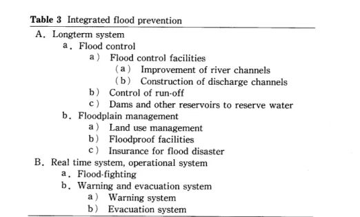
Scheme of floo prevention adopted by the Ministry of Construction
In order to promote flood p士evention, the Ministry of Construction asked the Commission on River Administration to study the basic premise of integrated flood prevention. That Commission s report stressed:
1.Energetic promotion of integrated flood prevention.
2.Promotion of the following items and establishment of a necessary system:
a. Water reserves and other necessary facilities should be provided.
b.Establishment of flood risk zones and debris・flow risk zones and the announcement of the results.
c.Establishment of long term and short term plans to construct flood prevention facilities.
d.Establishment of a better land use system and building code to avoid flood risk,
e.Enforcement of warning system and an evacuation system.
f.Establishment of risk zones for debris avalanche.
g.Enforcement of flood fighting system.
h.Promotion of understanding by the people of the area.
The items mentioned above are reasonable and should be instituted for the people living in the area prone to flooding. The Ministry of Construction has adopted these items and has proposed the basic scheme of flood prevention on the basis of three main vlewpOlnts:
1.Rivers flowing down into urban areas should be equipped with flood prevention facilities without delay.
2.Since much financial support and time are required in order to equip a river basin with flood prevention facilities, the construction of such facilities cannot be made to keep pace with the urbanization of a river basin.
3.Therefore, the function of the upper and middle parts of a river basin such as reserving and storing rainwater must be conserved so as not to increase a flood discharge in the lower reach of a river.
Table 3 1ntegrated flood prevention A.Longterm system
a.Flood control
a) Flood control facilities
(a) Improvement of river channels (b) Construction of discharge channels
b) Control of run.off
c) Dams and other reservoirs to reserve water b.Floodplain management
a)
b)
c)
Land use management Floodproof facilities Insurance for flood disaster B.Real time system, operational system a.Flood−fighting
b.Warning and evacuation system a)Warning system b) Evacuation system
The proposed scheme is shown in Table 3. The practical application of integrated flood prevention started in 1978. Now it is under execution in 14 river basins including the Tsurumi River Basin. Intense urbanization, rapid increase of population and frequent occurrence of inundation are common in all these river basins.
Integrated countermeasures for flood hazards to the Tsurumi River Basin
When the river improvement plan was reexamined after the flood disaster of 1976, the maximum peak flood discharge was supposed to be 2,300 m3/sec at the point near the Sueyoshi Bridge in the lower reach of the Tsurumi River. Since 500 m3/sec of discharge water were supposed to be controlled in a reservoir to flow through a drainage canal, a discharge capacity of 1,800 m3/sec was designed as the peak flood discharge in the lower reach of the Tsurumi River. However, it is very difficult to make the discharge capacity of the Tsurumi River increase to 1,800 m3/sec. Also, the construction of new drainage canal or reservoir is almost impossible. Because of the intensive land use for residential, commercial and industrial districts covering the alluvial plain and the high land prices, it is extremely difficult to attain a broad tract of land for public use. In point of fact, the discharge capacity of the Tsurumi River was only 500 m3/sec in 1971. The alluvial plain of the river basin was in such a state that inundation will occur once in several years. Accordingly, the river improvement for the purpose of increasing its discharge capacity to 950 m3/sec is being carried out as the provisional countermeasure.
The discharge capacity of 950 m3/sec is not unreasonable. When the strategy of the integrated flood prevention was discussed in the Ministry of Construction, it was proposed that a river basin has to be divided into three regions on the basis of a function for flood prevention:awater stagnating area, a water reserving area, and a built−up lowland area. A water stagnating area where it is designated in the upper and middle part of a river basin, functions to prevent rainwater from rushing into a lowland or a river channel. A water reserving area is a floodplain along the upper and middle reaches
of a river channe1. Flooded water as well as rainwater is reserved for a while so as to cut the peak discharge in the lower reach. However, since land use has usually proceeded in this area, inundation must be prevented if possible. A built・up lowland area must be protected from a flood.
If the Tsurumi River Basin is hit by a heavy rain with an intensity of 50 mm/hour, the peak discharge is supposed to reach 1,260 m3/sec in the lower reach. However, it is expected that water storage areas and the river channels accommodate 130 m3/sec and 180m3/sec, respectively. Accordingly, the peak discharge of the lower reach is reduced to 950 m3/sec. The planned peak discharge of 950 m3/sec has been calculated in order to prevent inundation both in the lowland built・up areas and the water reserving areas,
even though a heavy rain with the intensity of 50 mm/hour hits the Tsurumi River Basin.
However, the development of residential districts continues in the upper and middle parts of the Tsurumi River Basin. Effective measures to counter flood hazards, except improvement of river channels, have not been taken. Development guidelines involving non−structural measures for flood hazards are strongly recommended.
4.Strategy for Floodplain Management
Transformation of the area concerned
Urbanization and industrialization are rapidly progressing in floodplains in Japan and many other countries. This means that structural and functional changes are going on there. Agricultural areas are becoming urbanized and strategies for floodplain management are changing. Due to the progress and development of drainage basins,
floodplain management must encompass urbanized areas. Floodplain management
should be planned on the basis of the socio・economic status of the area in question. It is important to understand the physical characteristics of the land area concerned in order to prevent its misuse and to complete socio・economic adjustments for flood hazards.
Understanding the physical character㎏tics of the basin
Understanding the physical characteristlcs of the area concerned is fundamentally important, particularly for technological adjustment to flood hazards. The items to be considered are as follows:
Pαs 緬04disαsters
Floodplains have been formed by repeated floods. Microgeomorphological analysis of terrain surface is important in the understanding of surface lithology and micro・relief of the ares. The geology of a drainage basin and hydrological data are also fundamentally important. For instance, places of debris supply and hydrological characteristics of the river in question are needed. Such basic information in Japan is gathered in the form of the Land Classification Maps with an explanatory text. Mapping scale is regulated by the National Land Survey Law. Japanese territory is covered by such maps as a land classification map, a surface lithology map and a soil map on a scale of 1:200,000.
Important areas are covered by those maps on a scale of 1:50,0000r 1:25,000. Based on that data, past flood disasters can be analyzed from a hydrological point of view. In
addition,after the large flood disasters, inundated areas have been mapped. Such data are useful not only in understanding the flood・prone areas but also to instruct the people living there.
Delineat加(ゾrdSk zones
For floodplain management, a risk zone map based on probability will be usefu1. Based on scientific and technological data, risk zones can be established. In Japan, several laws establish a risk zone. However, lt is impossible to establish a risk zone by national or local governments, because huge investments for excluding such risk zones become necessary and resistance from the people living there is strong. Also, the accuracy of a risk zone map is a concern to the national and local governments. For better land use,
amicro・zonation map will be useful. However, it is not easy to make and use such a map effectively. Land owners do not like to be registered as being at risk although they agree they are. Such is one of the problems to be solved.
Technological adjustment
Floodplain management should be based on thorough understanding of the physical characteristics of the area concerned. However, technological adjustment has certain limitations. Such limitations are derived from financial investment, the difficulty of negotiating with the people, a lack of sufficient information, varied land use of the area concerned, the necessity of long time period until achievement, etc. Yet, technological adjustment is critically important for floodplain management.
Socio・economic adjustment
In order to avoid the risk of technological limitation, socio−economic adjustment will be helpful,
Inszarance
Simply speaking, insurance is the system by which an insurance company earns money and people of the area concerned share the risk. The upper limit of payment by insurance is strictly controlled by the government. Improvement of the insurance system is quite important in order to avoid and share the risk. For this purpose, it is essential to know the past damage experiences for each region. This is one of the reasons why we are keen to analyze past damages.
Warning systems and evacuation systems
Warning systems and evacuation systems are now major concerns of the government because they are effective in mitigating casualties. The beneficial effects of warning systems have been proven in the United States with tornado warnings. However,
overreliance on warning systems is not justified. In the case of flood hazards,
meteorological observation applying satellite imagery is effective. However, for a small area, even in Japan, an increase in the number of observation stations is necessary. An evacuation system is important for the people living in the area concerned. The evacuation system must be established based on an effective warning system. A warning system should have suitable equipment to transmit the necessary information;the people should be trained to understand the bulletins they will receive.
Land use management
One of the most difficult problems to be solved in Japan is land misuse. The law on national land use planning was issued, setting forth the strict control of land price, the promotion of proper land use and the allowance of time for land prices to rise. However,
land price is extremely high even in the areas located far from the center of Tokyo.
People are obliged to buy newly developed land of only l m2 in the upper part of the Tsurumi River Basin for about 300,000 yen which is nearly equivalent to 1,500 US dollars and to their average monthly salary. Such high priced land is apt to result in complicated and mosa三c・like land use and to promote an overcrowded population and properties. This results in an increase of high damage potential.
Assess〃zθ窺げ伽legal controlげ伽d鰯θα厩鋤吻lain〃zanage〃2θ窺
There are a number of laws, ordinances, rules, etc. related to land use and flood control. Those are useful and effective for land use control and floodplain management.
Unfortunately, however, the present situation of land use and floodplain management embody problems which must be solved. Legal control of land use and floodplain management should be assessed in order to improve the situation. Generally speaking,
although a certain standard of land use control exists, the situation of land use will never become better than the standard. In spite of the description of the laws, etc.,legal control of land use will not always function effectively due to poor political judgment.
6.Conc111ding Remarks
This paper has discussed flood hazards in the Tsurumi River Basin and the integrated measures to mitigate them. We also outlined the strategies for floodplain management and explained the necessity of socio−economic adjustment to flood hazards. However, as mentioned in the last chapter, it is very difficult to improve the land use of the floodplains. The general trend of transformation of the area concemed is often faster than the planned trend. Government control is not always strong enough to protect the sprawling of the urban area. Especially important are socio・economic adjustments such as regulatory control on land development, land use, etc. These are apt to meet with disapproval because people living in floodplains or owning the undeveloped land do not want their private rights restricted. Under the existing circumstances of flood hazard environments in Japan, the practicable and the most effective measures to counter flood hazards remain out of reach. Achieving these goals is quite remote.
This paper is a revised version of a document of the same title included in Working Paper N o.8, Land and Water Policy Center, University of Massachusetts of Amherst,
1984.The authors contributed it in order to dedicate to Professor Hiroshi Toya in commemoration of his retirement from Tokyo Metropolitan University.
References
Arai,1.(1982):Co mp rehensive Flood Control Policies in Construction Bureau, Ministry of Construction,119p*.
the United States. Tohoku Regional
Goudie, A.(1981):The、Humczn Impact ルlan s role in environ〃zental change. Basil Blackwell,
316p.
Keihin Work Office, Ministry of Construction(1977):1〜eport(ゾ魏6 Co吻繍 θ6かMαお膨s碗4 Plannin8「to Flood Ha2ards in the Tsuru〃ziム〜iz/er」磁5ゴη.36p*.
Leopold, L. B.(1971):The hydrol6gic effects of urban land use. In Detwyler, T. R.(ed.) 孤伽苫 imPact on Environ〃zent , McGraw−Hi11,205−216。
Miyata, M.(1969):Variation of runoff and flood damages caused by urbanization in the Shakujii River Basin, Tokyo. Geographical Review q〆ノmPan,42,667・680**.
Nihon Koso Kaihatsu Kenkyujo(1979):Shigaifea Kuilei Settei−Toshi Keikaleu Kuiki ni」Kansum Toshi・Keisei Chyosa(1〜esearchρ/ 乙frban Develop〃zentノわ7 De〃neating City Plznning/L㎎4ノ.
Ministry of Construction,79p*.
Oya, M. and Uchida, K.(1969):The relationship between geomorphology and flooding in the Basin of Tsurumi River in Yokohama City. Scientzfic、Researches,18,265−283**.
Walling, D. E(1979):Hydrological processes. In Gregory, K. J. and Walling, D. E.(eds.) Man and Environmental Processes , Westview Press,57−81.
Ward, R.(1978):Floods. Macmillan Press,244p.
Watanabe, K, Matsuda,1., Wakamatsu, K. and Uchida, K.(1981):Urbanization and fiood disaster in the Tsurumi River Basin. Proceedings of 24th、rnternational Geographical Congress,
∠4Pl)endix, 40−48.
White, G.E and Haas, J.E(1975):Assess〃zentげ1〜esearch on Natural Hazard. MIT Press,487p.
Williams, P.(1976):Imapact of urbanisation on the hydrology of Wairau Creek, North Shore,
Auckland.ノ∂ur. Hydrology(New Zealand).15(2),81−99.
(*in Japanese,**in Japanese with English abstract)