Evaluation of the coverage of emergency
medical services : the case of western medical area in Tokushima Prefecture
著者(英) Tohru Naito
journal or
publication title
Doshisha Shogaku (The Doshisha Business Review)
volume 72
number 6
page range 1229‑1242
year 2021‑03‑12
権利(英) Doshisha Daigaku Shogakkai
The Association of Commerce Doshisha University
URL http://doi.org/10.14988/00027965
Evaluation of the Coverage of Emergency Medical Services : The Case of Western Medical Area in Tokushima Prefecture*
Tohru Naito
†1 Introduction 2 The study area
3 Emergence medical services 4 Concluding remarks
1 Introduction
Recently, the percentage of aging of population has increased, thus changing the structure of diseases in society. Consequently, the number of ambulance calls has increased as well, and emergency medical services in many regions have become tight. According to 2018 data from the Fire and Disaster Management Agency of the Ministry of Internal Affairs and Communications, the number of people transported by ambulances has increased by 50.5%
over the past 10 years.
Saving of lives is a race against time. The difference between life and death depends on whether a patient can receive the first lifesaving treatment within 60 minutes. According to the golden hour principle, if the first lifesaving procedure is not performed within 60 minutes, patient mortality rises sharply. However, as the number of ambulance calls increased by 31.3% between 2003 and 2017, emergency medical systems in each region could be in a bind.
The finite number of ambulances and advanced medical facilities makes it difficult to prepare a sufficient number of them to cover all areas. Therefore, they need to be deployed and operated efficiently. In general, the uneven distribution of medical facilities and medical staff is a serious issue for a particular region when a patient experiences emergency sickness or injury. Recently, most of local governments have been reducing or shortening many kinds of
────────────
*This work was supported by JSPS KAKENHI GrantsinAid for Scientific Research (C) Numbers 18 K 01632. This research was the result of the joint research with CSIS, the University of Tokyo (No.983) and used the following data : Population Census : Preliminary Counts of the Population on the Basis of Summary Sheets (by municipality) data provided by Sinfonica. and Digital Road Map Database extended version 2017 provided by Sumitomo Electric Industries, Ltd. of Japan.
†Email : [email protected]
(1229)229
public services due to the severe financial situation.
This paper aims to investigate the current situation of the emergency medical system and point to any policy to improve it in the western part of Tokushima Prefecture in Japan.
Several studies have been conducted on the accessibility and optimal location of medical and public facilities. Some studies have applied geographic information systems (GIS) to analyze the optimal location of such facilities. Hayashi and Niimi[2] analyzed the structure and reality of the spatial supply system of emergency medical services in Aichi Prefecture. Yamamoto et al.[6] clarified the status of the emergency medical information system in Chiba City based on emergency and rescue statistics there and examined the optimal allocation of emergency and medical facilities in the city. Kawabata[3] also analyzed the accessibility of nursing facilities in Bunkyo Ward using a geographic information system (GIS). Considering these studies, we analyze the supply of emergency medical services in the second western medical area of Tokushima Prefecture in Japan. Kimura et al.[4] clarified the characteristics of accessibility to emergency hospitals by secondary medical care sectors in Shimane Prefecture with GIS.
The remainder of this paper is structured as follows. In Section 2, we show the geography of Tokushima, which includes natural features, demography, transportation, and western medical area. We will visualize the location, potential patient distribution, and network of emergency medical services in the second western medical area using GIS in Section 3.
Moreover, we measure the value of Moren’s I to examine clusters of elderly people who are hospitalized and potential patients in the second western medical area of Tokushima Prefecture.
We simulate the coverage area of ambulances and investigate whether there is a gap in emergency medical services in Section 4. Finally, we conclude this paper and discuss the remaining issues.
2 The study area
2.1 Natural features
First, we refer to the study area in this paper and show the current geographical situation there. We highlight the second western medical area in Tokushima Prefecture, located in the eastern prefecture of Shikoku Island, Japan (Fig. 1). The prefectural office is headquartered in Tokushima City, located in the eastern area of Tokushima Prefecture. As for the natural features of Tokushima Prefecture, the residential area is only 24.36%, although the total area covers 4147 km2. Since most of the central part is occupied by Shikoku mountains, residential
230(1230) 同志社商学 第72巻 第6号(2021年3月)
areas spread out along the Kii Channel and Yoshinogawa River. The Yoshinogawa River is streamed from the western area to the eastern area in the northern part of Tokushima Prefecture. This is one of the biggest rivers in Japan and is nicknamed Shikoku-Saburo, which is one of three major rivers in Japan. Economic zones have been developed along this river.
The annual mean temperature of each place observed from 1981 through 2010 was approximately 16°C. In general, the climate in the eastern coast area is warmer than that in the western mountain area.
2.2 Demography
In 2020, the population and number of households in Tokushima Prefecture were 723,198 and 309,584, respectively. Furthermore, focusing on the population distribution, we can see that the population of Tokushima Prefecture agglomerates in the municipalities near Tokushima City. Fig. 2 depicts the population distribution of Tokushima Prefecture in 2015. One dot in the figure represents 700 people. As we can see from this figure, most of the population agglomerates in the eastern municipalities including Tokushima City. Conversely, the number of dots contained in the western areas, on which we focus in this paper, is relatively small.
Fig. 3 shows that the population there has had a tendency of decreasing since 1990. Although the population in Tokushima Prefecture has decreased since 1980, the aging rate has also increased. The aging rate in Tokushima Prefecture reached 32.4% in 2017 and is expected to reach 40.2% in 2045.1
────────────
1 (Source) National Institute of Population and Soial Security Research homepage. (http : //www.ipss.go.jp/index- e.asp).
Figure 1 Map of Tokushima Prefecture in Japan
Evaluation of the Coverage of Emergency Medical Services(Naito) (1231)231
2.3 Transportation
In general, railways and automobiles are usually used when people move within Tokushima Prefecture. There are three major railway networks, which consist of the JR Kotoku line, Mugi line, and Tokushima line. When the passengers move from Tokushima City to Miyoshi City or Higashi Miyoshi Town included in the western medical area, they make use of the Tokushima Line along the Yoshinogawa River. As for highways, there are also two highways in Tokushima Prefecture, which are Takamatsu Exp. and Tokushima Exp. Toskushima Exp.
Figure 2 Population distribution in Tokushima (2015)
Figure 3 Transion of population in Tokushima Prefecture 232(1232) 同志社商学 第72巻 第6号(2021年3月)
connects the eastern and western parts of Tokushima Prefecture and runs north of the Yoshinogawa River. It takes approximately one and a half hours by limited express from Tokushima Station in Tokushima City to Awa-Ikeda Station, which is located in the center of Miyoshi City. However, it takes about 2 hours from Tokushima I.C. to Ikawa-Ikeda I.C. The Tokushima Exp. extends to Kawanoe JCT, where it connects to expressways bound for Kagawa, Kochi, and Ehime Prefectures. As for the main Japan National Route, Routes 11 and 55 connect from the southern area to the north along the eastern coast of Tokushima Prefecture. Route 192 connects eastern to western areas.
As for the airport and ferry port, they are located along the east coast of Tokushima Prefecture. Regular air routes connect Tokushima to Tokyo and Fukuoka. The ferry operates between Tokushima and Wakayama, Tokyo, and Fukuoka. No passengers, however, make use of airlines or ferries when they move within the prefecture. Therefore, we can ignore these modes of transportation.
2.4 Western medical area
2.4.1 Demography in western medical area
Here, we focus on Tokushima Prefecture in Japan. Since medical service areas differ from the political areas in Japan, we need to consider a definition of a medical service area.
Although Tokushima Prefecture consists of 24 municipalities, the medical service areas are divided into three : the eastern, southern, and western. Moreover, the western medical service area, which we study in this paper, can be further divided into the first western medical service area, including Mima City and Tsurugi Town, and the second medical service area including Miyoshi City and Higashi-Miyoshi Town. In particular, we highlight the latter. The population of Miyoshi City and Higashi-Miyoshi Town in 2020 was 25,122 and 14,163, respectively. Although the aging population rates in Moyoshi City and Higashi-Miyoshi Town were 32.2% and 25.7% in 2000, respectively, they eventually reached 28.9% and 36.2%, respectively. The expected aging rates in Miyoshi City and Higashi-Miyoshi Town to reach 54.2% and 42.5%, respectively.
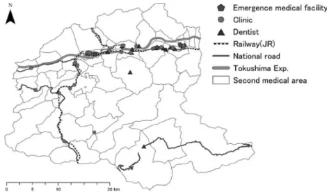
Next, we refer to the supply side of medical service, There were 37 hospitals and 21 dentists in the second western medical area, including Miyoshi City and Higashi-Miyoshi Town in 2014. The number of doctors and dentists in the second western medical area was 74 and 28 in 2018, respectively. As for emergence medical facilities, there are three hospitals to accept emergency patients asemergence medical hospitals: Mino Hospital, Miyoshi Hospital, and Mikamo-Tanaka Hospital. Figure 4 depicts the distribution of hospitals and dentists in the
Evaluation of the Coverage of Emergency Medical Services(Naito) (1233)233
second western medical area of Tokushima Prefecture. Although this area consists of 67 blocks, the number of blocks including hospitals is only 18 in this area. As for the number in Tokushima Prefecture, it is 329.5 people engaged per 100,000 people in Tokushima in 2018.
Although this figure is the largest in Japan, the distribution of doctors is not even. Most of them reside in the eastern medical area. The number of doctors in the western medical area has decreased since 2002. According to the Survey of Physicians, Dentists, and Pharmacists 2002-2018, the number of doctors in the western medical area has decreased from 195 to 157.
In particular, the numbers of pediatricians and obstetricians and gynecologists in this area were 9 and 1, respectively, in 2018. Consequently, emergency medical hospitals are currently not accepting pediatric patients. Moreover, the birth environment in this area has deteriorated because there is only one obstetrician and gynecologist. On the other hand, 77% of doctors in Tokushima Prefecture agglomerate in the western medical area, including Tokushima City.
Therefore, the medical environment in this area is not necessarily good and needs to be further enhanced.
3 Emergence medical services
This paper aims to investigate emergence medical services in the second western service area and identify their vulnerabilities and possible improvements. First, we investigated the distribution of hospitals and dentists in the area. Second, we plotted the location of the fire
Figure 4 Map of transportation in Tokushima Prefecture 234(1234) 同志社商学 第72巻 第6号(2021年3月)
station with an ambulance car within the area and population distribution. Finally, we analyzed the relationship between preliminary patients and coverage for emergency medical services.
3.1 Hospital
We plotted the locations of hospitals and dentists to grasp the distribution of medical facilities in this area. We obtained some data to analyze their distribution within the area. As for the location data of hospitals and dentists, we obtained them from the digital national land information web page provided by the Ministry of Land, Infrastructure, and Transport in Japan and the Japan Medical Analysis Platform provided by the Japan Medical Association. As for other geographical information, we used administrative divisions (population, transportation), and we made use of national census data for each year. Finally, we counted the number of hospitals included in each block using ArcGIS Pro and visualized them on a map.
Figure 5 Hospitals and dentists in second medical area of Tokushima Prefecture (2018)
Figure 6 Agglomeration of hospitals and blocks without a doctor
Evaluation of the Coverage of Emergency Medical Services(Naito) (1235)235
As we can see from Fig.5, most of hospitals are concentrated in blocks along Route 192 and in the north part of second medical area. In left map of Fig. 5, colored blocks denote places where some doctors exist, while non-colored blocks mean that there are no doctors.
Although we know that the blocks with a doctor spread along Routes 192 and 34, most of the southern blocks have no doctors. Therefore, it is not covenant for patients there to go to emergency medical facilities. The ratio of non-colored blocks to total blocks in the second medical area in Tokushima Prefecture is approximately 70%. However, we need to confirm whether the cluster is statistically significant because it is possible that spatial data include spatial associations. We perform hotspot analysis to confirm whether the cluster is statistically significant and make use of Local Moran’s I as local indicators of spatial association. Local Moran’s I is defined as follows :
!$$($!(
"$$
"
%$#!%$#$
&
'$%!(%!(" (1)
"$$"
!
%$#!%$#$
&
!(%!("
&!# , (2)
where &, ($, (, and '%#are the sample size, attribute value of feature, average of value of feature, and the spatial weighted matrix.2 The right map of Figure 6 describes the results of hot-spot analysis. We could not confirm the cluster of hospitals there, although we could confirm only one block in front of Awa-Ikeda Station, which is the gate station of Miyoshi City. A block colored in red denotes the area without any surrounding hospitals. A block colored in blue denotes that all blocks around it have hospitals. Moreover, we confirm that only one block in front of Awa-Ikeda Station is a medical cluster because the blocks colored red also include only one hospital.
3.2 Emergency medical system 3.2.1 Emergency medical facility
Next, we consider the emergency medical system in the second western medical area in Tokushima Prefecture. First, we review the emergency medical system in Japan. The Japanese emergency medical system is classified into three degrees. The first-degree emergency medical facility is a hospital or clinic that accepts patients who do not have to be hospitalized and are
────────────
2 We adopt edges and/or corners as the concept of spatial relationship. Under this concept, polygons that share edges and/or corners are included in the calculation of the target polygon. We consider both polygons to be closed and take 1 when any part of the two polygons overlap.
236(1236) 同志社商学 第72巻 第6号(2021年3月)
able to go home after emergency aid. The second-degree emergency medical facility is a hospital that accepts patients who need to be hospitalized for medical treatment. The third- degree emergency medical facility is a hospital that accepts patients, for which the second emergency medical facility cannot provide medical treatment. Although we have already shown the distribution of hospitals and clinics in Fig. 5, we extracted emergency hospitals from all hospitals there. There are only three high-degree emergency medical facilities whose names are Miyoshi, Mikamo-Tanaka, and Mino Hospital in this area.
3.3 Ambulance
The ambulance is deployed in a fire station in Japan. After receiving a dispatch request, emergency life paramedics pick up the patients, perform the first aid, and quickly decide on the destination hospital that can accept patients being in need of emergency medical care to transport them there. Fig.7 shows the transition of the number of emergency dispatch requests in the western medical areas of Tokushima Prefecture from 2010 to 2018. The number of emergency dispatch requests in the second western medical area in Tokushima Prefecture increased by approximately 16% from 2010 to 2018 and is on the rise. On the other hand, the number of fire stations with ambulance cars did not increase. Therefore, the emergency medical system in this area has been tight.
Figure 7 The number of emergency dispatch request from 2010 to 2018
Evaluation of the Coverage of Emergency Medical Services(Naito) (1237)237
3.4 Arrival area
3.4.1 Ambulance arrival area
The response time is the time taken for a patient to start treatment after a situation occurs. The standard response time is determined for each country. For instance, the response time in Germany, Canada, and Swaziland is about 8 minutes. The relationship between mortality and treatment start time is often called “the Golden Hour Principle”. According to the Golden Hour Principle, mortality increases significantly if lifesaving treatments are not initiated within 1 hour. Thus, the rapid delivery of patients to emergency medical facilities is of utmost importance. In general, lifesaving medical activities have three stages. The first stage is the movement from the fire station with an ambulance to the lifesaving point after receiving the dispatch request. The second stage is the lifesaving treatment on the spot. Finally, the third stage is transportation from that spot to emergency medical facilities. Some GIS studies often use direct distance from a fire station or emergency medical facility to analyze arrival areas. It is inadequate to use the direct distance to analyze the arrival areas because the ambulance does not move directly from the fire station to the spot to be requested. We had a better outcome using the actual travel distance to analyze the arrival area in detail. Therefore, we calculated the arrival area of the ambulance from each fire station located in the second western medical area of Tokushima Prefecture with an actual road there.
We obtain the road data from the OpenStreetMap Data web page to revise them adequately and depict the data for that area3. We set the arrival time of the ambulance within 15 minutes
────────────
3 http : //download.geofabrik.de/index.html
Figure 8 Arrival area within 15 min. from fire station 238(1238) 同志社商学 第72巻 第6号(2021年3月)
in our model. Fig.8 describes arrival area within 15 min. from each fire station. This area extends along the Tokushima expressway on the north of the second western medical area.
The non-colored area marks the area in which an ambulance car cannot arrive in 15 min.
3.4.2 Conveyance time for patients
Next, we analyzed the conveyance time for patients from the spot to emergency medical facilities within 15 min. As we have referred to emergency medical facilities in the second western medical area in Tokushima Prefecture, there were three emergency facilities in this area. Fig.9 describes the area from the spot to emergency medical facilities within 15 min.
Compared in Fig.8 and Fig.9, the arrival area within 15 min. from each fire station is smaller than that from the spot to emergency medical facilities. Although the northern areas in the second medical area of Tokushima Prefecture are covered by area in 15 min., most of the southern area is not covered in 15 min. Therefore, it is considered a high-risk area, in which serious emergency cases occur. If we consider the Golden Hour principle, it is necessary to establish additional emergency medical facilities to cover the southern areas.
3.4.3 The demand side situation of emergency medical service
We have analyzed the emergency medical facilities situation regarding emergency medical service. Next, we consider the demand side situation of it. Since an emergency case does not depend on location, it is necessary to respond to it despite of a place or time. Therefore, we also took account of the population distribution in the areas when we had to make a planning of emergency medical service. We combine Figs. 8 and 9 with the population distribution. We
Figure 9 Arrival area within 15 min. to emergency medical facilities
Evaluation of the Coverage of Emergency Medical Services(Naito) (1239)239
used 500 m mesh data to describe the potential demand for emergency medical services in the second western medical area in Tokushima Prefecture. We obtained 500 m mesh data for the population from e-Stat to be a portal site for Japanese Government Statistics. Since the 500 m mesh data were published in 2015, we used them. These mesh data contain information on the population by age. First, we consider the relationship between population distribution and arrival areas within 15 minutes from each fire station in the second western medical area.
Fig.10 shows the relationship between population distribution and arrival areas in 15 min.
from each fire station.
As we can see from Fig.10, the relatively high population density areas are within 15 min.
of a fire station. On the other hand, most of the areas, which are relatively less dense, are outside a 15 min. radius from a fire station. As the areas in which the ambulance can arrive in 15 min. from a fire station generally cover most of the high-density areas in the second western medical area, it is possible to consider that efficient ambulance deployment has been achieved. However, the absolute number of fire stations with ambulance is inadequate because it is impossible for most areas to be reached by ambulance in 15 min. In particular, there are many areas in the southwest of the second western medical area in Tokushima Prefecture.
Next, we consider the relationship between population distribution and arrival area from an emergency medical facility. Fig.11 shows the relationship between population distribution and arrival areas within 15 min. from each emergency medical facility. As we know from Fig.11 emergency medical facilities agglomerate in the northern area of the second medical area in Tokushima Prefecture. Areas that overlap with fire stations with ambulance cars and emergency medical facilities within 15 min. are even narrower than the colored areas in Fig.10
Figure 10 Population and arrival area within 15 min. from fire station 240(1240) 同志社商学 第72巻 第6号(2021年3月)
and Fig.114.
────────────
4 The source of future elderly distribution in 2020-2050 are the data published in Digital national land information
Figure 11 Population and arrival area within 15 min. from an emergency medical facility.
Figure 12 Elderly distribution and emergency medical services available within 15 minutes
Evaluation of the Coverage of Emergency Medical Services(Naito) (1241)241
4 Concluding remarks
In this study, we analyzed the coverage of the ambulance vehicle with GIS. We focused on the second western medical area in Tokushima Prefecture and clarified the supply of emergency medical services, their potential demand, and the arrival range of ambulance vehicles within 15 min. from the nearest fire station and to the nearest medical facility. First, we visualized the geographical situation and the distribution of medical facilities or staff in Tokushima Prefecture and clarified the uneven distribution of population and medical facilities there. We set the total transport time of patients to 30 minutes based on the golden hour principle and visualized the range, in which an ambulance could transport patients to medical facilities within 30 minutes. The analysis results showed that the region had some areas where it was difficult to access emergency medical services. Recently, local governments have been reducing or shortening many kinds of public services due to the severe financial situation.
However, an excessive reduction in the provision of emergency medical services is not necessarily good for society. Therefore, it is necessary to construct an efficient emergency transport network, while maintaining the current level of emergency medical services.
References
[1] Fujii, T., A. Otani, and Y. Matsumi, (2011) “Assessment of vulnerability of emergency service using geographic information system,”Journal of JSCE,67(2), pp.137-142. (in Japanese)
[2] Hayashi, N. and Y. Niimi (1998) “Spatial supply system of emergency medical service in Aichi prefecture,”
Annals of the Japan Association of Economic Geographers,44, pp.165-186. (in Japanese)
[3] Kawabata, M. (2014). “Childcare access and employment : The case of women with preschool-aged children in Tokyo,”Review of Urban & Regional Development Studies,26(1), pp.40-56.
[4] Kimura, Y., T. Hamano, and K. Shiwaku, (2012) “Evaluation of coverage for emergence medical services in Shimane prefecture using Geographic Information System,”Journal of the Japanese Association of Rural Medicine,60(2), pp.66-75. (in Japanese)
[5] Yogita, S. and Y. Matsuzaki, (2012) “Current status and problems of emergency medicine in western areas of Tokushima Prefecture,”Shikoku Acta Medica,68(5-6), pp.169-176. (in Japanese)
[6] Yamamoto, A., A. Kaneko, and H. Ouchi, (2003), “Empirical study on the compound use system covering the wide area in the area of the emergency medical using Web GIS/GPS-Empirical study on optimal location planning of emergency facilities medical facilities complex in Chiba city,”The AIJ Journal of Technology and Design,17, pp.499-502. (in Japanese)
242(1242) 同志社商学 第72巻 第6号(2021年3月)