Seismic Reflection Survey in Nagamachi-Rifu
Fault, Sendai, Northeastern Japan
著者
Research Group for Deep Structure of
Nagamachi-Rifu Fault
雑誌名
The science reports of the Tohoku University.
Fifth series, Tohoku geophysical journal
巻
36
号
3
ページ
311-356
発行年
2002-03
TOhoku Geophys. Journ. (Sci. Rep. TOhoku Univ., Ser. 5), Vol. 36, No. 3, pp. 311-356, 2002
Seismic Reflection Survey in Nagamachi-Rzfu Fault,
Sendai, Northeastern Japan
RESEACH GROUP FOR DEEP STRUCTURE OF NAGAMACHI-R/FIJ
FAULT*
Research Center for Prediction of Earthquakes and Volcanic Eruptions, Graduate School of Science, Tohoku University, Aoba-ku, Sendai, 980-8578
(Received January 7, 2002 ; revised January 29, 2002 ; accepted January 31, 2002)
Abstract : On September 15, 1998, an earthquake with M5.0 occurred at 12 km depth
beneath Sendai City, northeastern
Japan, and caused slight damages in the city.
The
epicenter of this earthquake was located about 10 km to the northwest of the
Nagamachi-Rifu fault, an active fault running through the middle of the urban area of Sendai City in
the NE-SW direction.
By using reflected S-waves observed in seismograms of the
after-shocks, distinct S-wave reflectors (bright spots) were located beneath the focal area of this
earthquake.
A seismic reflection/refraction
experiment
was conducted
around
the
Nagamachi-Rifu
fault in June, 2001. We observed 15 chemical explosions and
VIBRO-SEIS signals by a crisscross seismic array composed by 368 off-line data recorders deployed
on the hanging wall side of the fault. Predominant reflection events were observed at about
5 sec in two-way travel-time
on some shot gather record sections.
They correspond to the
reflection from the deep structure
of the Nagamachi-Rifu
fault.
Moreover, reflection
events were also observed at about 6-7 sec in two-way travel-time,
which were probably
caused by the reflections from the S-wave reflectors (bright spots).
1.
Introduction
Seismic reflection/refraction
experiments
around the Nagamachi-Rifu
fault,
north-eastern
Japan, were conducted
as a part of a comprehensive
joint research
project
"Modeling of Deep Slip Processes in Seismogenic
Inl
and Faults".
The purpose of the
experiments
is to reveal deep structures
of the fault, such as the geometry of the fault
Members of Research Group for Deep Structure of Nagamachi-Rifu
Fault
Authors of the report : Norihito Umino, Akira Hasegawa (Tohoku Univ.)
Participants
in field observation : Takeo Moriya, Ken Otsuka, Taka'aki
Taira (Hokkaido Univ.),
Tomoki Tsutsui, Katsuyuki Kobayashi (Akita Univ.), Akiko Hasemi, Tomotsugu Demachi, Kaoru
Takizawa, Mari Ishizawa, Takeo Shibuya, Yoshinori Yajima (Yamagata Univ.), Akira Hasegawa,
Norihito Umino, Toni Matsuzawa, Tomomi Okada, Ayako Nakamura, Toshiya Sato, Shuichiro
Hori, Toshio Kono, Koichi Nida, Takashi Nakayama,
Youichi Asano, Junichi Nakajima, Namiko
Sato, Naoki Uchida, Yoko Suwa, Kazuo Yoshimoto, Hisashi Nakahara,
Hideki Ueda, Tatsuhiko
Saito, Sachiko Tanaka,
Takuto
Maeda, Tsutomu Takahashi
(Tohoku Univ.), Masaki Kanao
(National Institute of Polar Research), Mikiya Yamashita
(The Graduate Univ. for Advanced
Studies), Takaya
Iwasaki, Takashi Iidaka, Yoichiro Ichinose, Mamoru Saka, Kaname Sakai,
Izumi Ogino, Masato Serizawa, Keiji Adachi (Univ. of Tokyo), Toshikazu Tanada (Hot Springs
Research Institute of Kanagawa Prefecture), Fumihito Yamazaki, Mamoru Yamada, Koji Aizawa
(Nagoya Univ.), Shigeru Toda (Aichi Univ. of Education), Kiyoshi Ito, Kazuo Matsumura, Hiroo
Wada, Setsuro Nakao, Koji Yoshii, Tomotake Ueno (Kyoto Univ.), Dapeng Zhao, Ryohei Sanda,
Toshiyuki Nishino, Takeshi Ono, Om P. Mishra, Inmaculada
Serrano, Mohamed K. Salah (Ehime
Univ.), Hiroki Miyamachi, Shuichiro Hirano, Naoki Hayashimoto
(Kagoshima Univ.)
312 RESEARCH GROUP FOR DEEP STRUCTURE OF NAGAMACHI-RIFU FAULT
in the seismogenic upper crust, its deeper extension in the lower crust, and seismic-wave
reflectors (bright spots) around it (Hasegawa
et al., 2001a).
Such information
is
neces-sary for modeling the deep slip processes in seismogenic inland fault system.
As is the
case for the vast majority
of active faults, however, very little information
is available
regarding the deep structure
of the Nagamachi-Rifu
fault.
The Nagamachi-Rifu
fault
is an active fault zone of reverse fault type, which runs the middle of the urban area of
Sendai City in the NE-SW direction.
The fault is about 15 km long, and its slip rate is
estimated to be 0.6-1.0 m/ka (Active Fault Research Group, 1991). It is inferred that the
most recent activity of this fault was 3000-2500 years ago (Otsuki, 1999).
An M5.0 earthquake
of reverse-fault
type occurred beneath the Ayashi area of
Sendai City on September
15, 1998, and it caused slight damage to houses and roads in
the city. The hypocenter of the earthquake
was located at a depth of about 12 km, about
10 km to the northwest
of the surface trace of the Nagamachi-Rifu
fault (see Fig. 1).
Focal mechanism of the M5.0 event determined
by P-wave polarity data is a reverse
fault type with a nearly horizontal
P-axis in the NW-SE direction.
Umino et al. (1999)
relocated hypocenters
of the main shock and aftershocks
by the homogeneous
station
method (Ansel and Smith, 1975). They are shown by a star and small open circles in Fig.
1. Most of aftershocks
were distributed on a 3 km x 3 km plane dipping about 30 degree
to the northwest.
The hypocenter
of the main shock was located at the lower edge of
the focal area.
From the relationship between the distribution
of hypocenters, the focal
mechanism of the main shock and the location of the surface trace of the
Nagamachi-Rifu fault, the M5.0 earthquake
is interpreted
to have ruptured the deepest portion of the
fault (Umino et al., 1999).
Recent activity
of microearthquakes
around the Nagamachi-Rifu
fault has been
studied by temporary
seismic observations
(Yoshimoto
et al., 2000) and by Tohoku
University
seismic network
data (Hasegawa
et al., 2001b). The results
show that
microearthquake
activity for the last 20 years or so concentrates
in the hanging wall side
of the Nagamachi-Rifu
fault.
A number of prominent
reflected S-waves
(SxS phases) were observed in
seismo-grams of foreshocks
and aftershocks
of the 1998 M5.0 earthquake
at many stations
surrounding its focal area (Hori et al., 1999). They have similar features to those of the
SxS phases widely detected in the midcrust of northeastern
Japan (Hasegawa et al., 1991,
2000). Based on the analysis of SxS phases, several S-wave reflectors (bright spots) are
located around the deep extension of the Nagamachi-Rifu
fault and in the lower crust
directly below it.
The locations of these reflectors are shown by short straight lines in
Fig. 1(b). Moreover, another predominant
reflector is located below the fault plane of the
M 5.0 event at depths of 15-22 km by using the arrival time differences at several nearby
stations.
It has an area of about 10 km x 10 km dipping to the north-northwest
direction
at about 25 degree.
The reflector surface is shown by iso-depth contours of thin solid
lines in Fig. 1(a), and by a thick gray line in Fig. 1(b). Recently, predominant
reflected
P-waves (PxP phases) have been also observed in seismograms
of the aftershocks
of the
SEISMIC REFLECTION SURVEY IN NAGAMACHI-RIFU FAULT 313
(a)
140.5°E 141.0°E1/
• A 0 -2.0 -1 .0 0.0 1.0 Residual (sec)el38.5°N
2_0I
38.0°N(b)
0 Nagamachi-Rifu Fault10
E
-5
G.
w 20
30C
I
1998/9/15 M5.0101.41
Reflection planeD
SxS PxPFig. 1. Estimated S-wave reflectors beneath the focal area of 1998 M5.0
earthquake.
(a) Depth distribution of a planar S-wave reflector and
reflection points.
Depth of the reflector is shown by contours.
Circles
and triangles show reflection points with positive and negative residuals
of SxS-S, respectively.
(b) Vertical cross section of the planar S-wave
reflector and other reflectors along line C-D in (a). Thick gray line
shows the planar S-wave reflector.
Thin solid and broken lines show
other reflectors.
Surface trace of the Nagamachi-Rifu
fault is shown by
a thick line. Thick arrows show the fault motion of the main shock.
the same origins as was previously pointed out by Hori et al., (1999).
In the 2001 seismic reflection/refraction
experiments
around the Nagamachi-Rifu
314 RESEARCH GROUP FOR DEEP STRUCTURE OF NAGAMACHI-RIFU FAULT
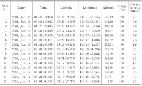
Table 1. Locations, shot times, charge weights and P-wave velocities of 15 shot points.
Shot No 1 2 3 4 5 6 7 8 9 10 11 12 13 14 15 Date
2001, Jun. 16
2001, Jun. 16
2001, Jun. 18
2001, Jun. 16
2001, Jun. 18
2001, Jun. 18
2001, Jun. 16
2001, Jun. 16
2001, Jun. 18
2001, Jun. 18
2001, Jun. 17
2001, Jun. 17
2001, Jun. 17
2001, Jun. 17
2001, Jun. 17
Time 01 : 01 : 00.000 00 : 01 : 00.022 01 : 26 : 00.015 00 : 31 : 00.049 00 : 31 : 00.000 00 : 01 : 00.001 01 : 31 : 00.039 02 : 01 : 00.016 02 : 01 : 00.029 02 : 16 : 00.016 01 : 31 : 00.030 02 : 06 : 00.027 00 : 01 : 00.009 00 : 31 : 00.043 01 : 01 : 00.055 Latitude 38-24- 9.2934 38-21-48.9578 38-24-18.9763 38-17-53.4700 38-24-28.6487 38-22-13.5097 38-19-40.5283 38-16-15.5036 38-23-14.2804 38-21-30.7535 38-17-58.3207 38-15- 4.8371 38-14- 3.1535 38-13-39.3738 38-12-27.7172 Longitude 140-31-40.9775 140-38-35.0824 140-44-16.1576 140-37-18.2699 140-47-46.9435 140-47- 4.1846 140-44- 2.4327 140-39-54.8276 140-50-33.4518 140-48-46.6395 140-45-37.3454 140-42-39.7932 140-48-10.6524 140-45- 5.7728 140-54-45.9039 Altitude 355.13 442.10 438.66 288.87 163.60 159.82 272.64 218.03 76.09 184.06 156.43 183.50 146.98 131.61 3.58Charge
(Kg)
100 130 100 100 100 100 70 100 100 100 100 100 100 100 100P-wave
velocity
(km/s)
4.1 2.0 2.8 2.3 3.0 2.3 1.9 2.1 2.7 2.3 1.7 2.4 2.5 3.3 2.3to investigate
the deep structure
of the Nagamachi-Rifu
fault
and its relation
with the
fault plane
of the 1998 M5.0 earthquake
and the bright
reflective
layers.
2. Field observations
The seismic reflection/refraction
experiments
were carried out in June, 2001. Two
reflection profiling receiver arrays form the backbone of the present seismic expeditions.
One of the profiles, Line A, the 22-km-long
NW-SE profile, is perpendicular
to the
surface trace of the Nagamachi-Rifu
fault, and the other, Line B, the 16-km-long
NE-SW profile, is parallel to the fault (Fig. 2). These two profiles are located on the hanging
wall side of the Nagamachi-Rifu
fault, and the Line B runs through the focal area of the
1998 M5.0 event.
Five small-aperture
seismic arrays, A1-A4 and Y1 in Fig. 2, were
installed
by the National
Institute
of Advanced
Industrial
Science and Technology,
AIST.
Five seismic arrays, 51-55 in Fig. 2, were installed in the southwestern
part of
the study area by Tohoku University. They are L-shaped seismic arrays by using DAT
recorders.
Similar L-shaped seismic arrays were installed in the Ou Backbone Range,
northeastern
Japan, and detected seismic scatterers
and reflectors (Okada and Seismic
Array Observation Group, 1998 ; Asano et al., 1999). They consisted of 20 stations with
a station spacing of 50 m. Details of the seismic reflection/refraction
experiments
were
reported in Hasegawa
et al. (2001a) and Ikawa et al. (2001).
Four vibrators were used for seismic wave sources.
Vibration points were spaced
200 m apart on average for a total of 174 vibration points along the reflection profiling
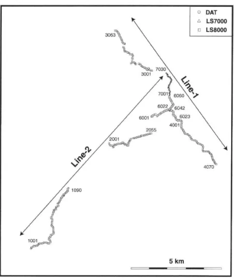
SEISMIC REFLECTION SURVEY IN NAGAMACHI-RIFU FAULT 315 140.5°E 38.5°N 38.1°N 141.0°E SP1 51
SPCA'
Fig. 2. Map showing locations of 2 reflection profiles, seismic arrays and 15 chemical explosions. Broken lines show the 22-km-long and 16-km-long
reflection profiles (Line A and Line B). Bold lines with numerals 10-70 show the locations of crisscross seismic array with off-line data
recorders. Bold lines with numerals 51-55 show the locations of L-shaped
seismic arrays operated by Tohoku University. Open and solid
monds show the locations of seismic arrays operated by GSI, A1ST.
Stars show the locations of 15 chemical explosions. Nag_ amachi-Rifu
fault is indicated by thin curves.
detonated
at 15 locations
(SP1-15 in Fig. 2). Eight of them were placed along the
reflection profiling Line A and Line B and their extensions.
Others except SP15 were set
up in the hanging wall side of the fault.
In the previous seismic refraction surveys, shot
points were usually aligned with the profiling line (e.g., Research Group for Explosion
Seismology, 1999a, 1999b, 1999c). In the present experiment, the locations of the
chemi-cal explosions
were arranged
in a 2D horizontal
array in order to reveal the spatial
extents of deep structure
of the Nagamachi-Rifu
fault and S-wave reflectors in the lower
crust.
Drilling and chemical explosions were carried out by Japex Geoscience Institute Inc.
316 RESEARCH GROUP FOR DEEP STRUCTURE OF NAGAMACHI-RIFU FAULT
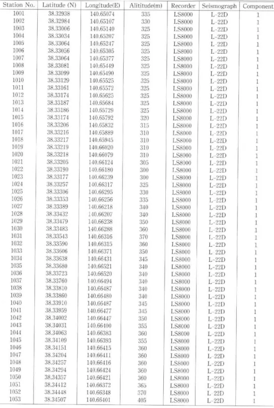
Fig. 3. Detailed map showing locations of stations for the crisscross seismic array. The locations of stations are indicated with 4-digit numbers, and
are listed in Table 2.
depth, each encased with a steel pipe of 10 cm inner diameter.
The height of the charge
of 100 kg was about 10 m, so that the depth to the top of the charge was about 20 m.
Surface P-wave velocities were determined
from arrival times of P-wave recorded on 3
seismographs
located very close to the drilled hole with a receiver spacing of 50 m. The
result is listed in Table 1 together with shot time, location and weight of charge (data
supplied by JGI).
We carried out a large seismic array observation to record these 15 shots (Research
Group for Deep Structure
of Nagamachi-Rifu
Fault, 2001 ; Nakamura
and Research
Group for Deep Structure
of Nagamachi-Rifu
Fault, 2001). A large crisscross seismic
SEISMIC REFLECTION SURVEY IN NAGAMACHI-RIFU FAULT 317
northern part of the study area (10-70 in Fig. 2). Geophones for the seismic array were
three-component or vertical-component sensors of 2 Hz (L22-D or L28-B [Mark
Prod-ucts Inc.]) or 4.5 Hz (L15-B [Mark ProdProd-ucts Inc.]). Off-line data recorders (DAT
recorder [Clovertech Co.], LS8000 logger or LS7000 logger [Hakusan Co.]) recorded
seismic signals from the vibrators or chemical explosions at a sampling rate of 100 Hz
with 16 bit or 22 bit A/D conversion. The DAT recorders and LS7000 loggers, having an
ability of long-term continuous recording, recorded seismic signals from 15 chemical
shots, VIBROSEIS signals and natural earthquakes.
On the other hand, the LS8000
loggers worked with a event trigger system, and only recorded signals from 15 chemical
shots. Locations and specifications of the seismic stations are listed in Table 2. Detailed
feature of the crisscross seismic array is shown in Fig. 3. Locations of seismic stations
were measured by portable Differential GPS surveys. Four crews of 8 members spent
3 days for measuring the locations of all the seismic stations by DGPS.
3. Seismic record sections
Shot gather record sections obtained by vertical-component
seismometers
for 15
chemical explosions, SP1-15 (Fig. 1), are shown in Fig. 4 for Line 1, and in Fig. 5 for Line
2, respectively.
These waveform
data are processed with a band-pass
filter of 6 to 24
Hz and a 2.0-sec trailing automatic
gain control correction.
Discontinuity
of the shot
gather record section for Line 2 (Fig. 5) is due to a station gap of about 3 km between
station 1090 and station 2001 (see Fig. 3).
Several predominant
reflection events are observed
on these shot gather
record
sections.
Reflection events at about 5-6 sec in two-way
travel-time
are recognized,
which are shown in Figs. 4 and 5 by solid triangles.
These events correspond
to the
depth of the fault plane of the 1998 M5.0 earthquake
(Nakamura
and Research Group for
Deep Structure
of Nagamachi-Rifu
Fault, 2001). Reflection events at about 6-7 sec in
two-way
travel-time
are recognized,
and are shown in Figs. 4 and 5 by solid circles.
These events correspond to the depth of the S-wave reflector in the lower crust (Hori et
al., 1999). Reflection events at about 3-5 sec and about 8 sec in two-way travel-time
are
recognized, and are shown in Figs. 4 and 5 by open triangles and circles, respectively.
Moreover,
reflection
events at about 10 sec in two-way
travel-time
are sometimes
recognized.
They correspond to the depth of the Moho discontinuity
(Hasegawa
et al.,
2001a).
It is hoped that future precise analyses of those records will clarify the deep
structure
of the Nagamachi-Rifu
fault and the structure
of the S-wave
reflecting
surfaces (bright spots).
4. Conclusion
Seismic experiments
were carried out for the purpose of clarifying the deep
struc-ture of the Nagamachi-Rifu
fault.
Well-developed
late Cenozoic calderas are
318 RESEARCH GROUP FOR DEEP STRUCTURE OF NAGAMACHI-RIFU FAULT
Table 2. Locations, type of recorders and seismographs of seismic stations.
Station No. 1001 1002 1003 1004 1005 1006 1007 1008 1009 1010 1011 1012 1013 1014 1015 1016 1017 1018 1019 1020 1021 1022 1023 1024 1025 1026 1027 1028 1029 1030 1031 1032 1033 1034 1035 1036 1037 1038 1039 1040 1041 1042 1043 1044 1045 1046 1047 1048 1049 1050 1051 1052 1053 Latitude (N) 38.32938 38.32984 38.33006 38.33034 38.33064 38.33056 38.33064 38.33081 38.33099 38.33129 38.33161 38.33174 38.33187 38.33186 38.33174 38.33206 38.33216 38.33217 38.33219 38.33218 38.33205 38.33190 38.33177 38.33257 38.33306 38.33353 38.33389 38.33432 38.33479 38.33483 38.33543 38.33590 38.33606 38.33638 38.33680 38.33723 38.33760 38.33810 38.33860 38.33910 38.33959 38.34002 38.34031 38.34063 38.34109 38.34151 38.34204 38.34257 38.34294 38.34357 38.34412 38.34448 38.34507 Longitude(E) 140.65074 140.65107 140.65140 140.65207 140.65247 140.65305 140.65377 140.65449 140.65490 140.65525 140.65572 140.65625 140.65684 140.65729 140.65792 140.65832 140.65889 140.65945 140.66020 140.66079 140.66124 140.66180 140.66239 140.66317 140.66295 140.66256 140.66218 140.66207 140.66238 140.66288 140.66316 140.66315 140.66371 140.66431 140.66521 140.66520 140.66494 140.66487 140.66480 140.66487 140.66477 140.66447 140.66400 140.66383 140.66393 140.66415 140.66411 140.66416 140.66424 140.66421 140.66372 140.66348 140.66401 Alititude(m) 335 330 325 325 325 325 325 325 325 325 325 325 325 325 320 315 310 310 310 310 305 300 300 325 330 335 340 340 350 360 370 360 350 345 340 340 340 340 340 345 345 350 355 360 355 360 360 360 360 360 365 370 405 Recorder LS8000 LS8000 LS8000 LS8000 LS8000 LS8000 LS8000 LS8000 LS8000 LS8000 LS8000 LS8000 LS8000 LS8000 LS8000 LS8000 LS8000 LS8000 LS8000 LS8000 LS8000 LS8000 LS8000 LS8000 LS8000 LS8000 LS8000 LS8000 LS8000 LS8000 LS8000 LS8000 LS8000 LS8000 LS8000 LS8000 LS8000 LS8000 LS8000 LS8000 LS8000 LS8000 LS8000 LS8000 LS8000 LS8000 LS8000 LS8000 LS8000 LS8000 LS8000 LS8000 LS8000 Seismograph L-22D L-22D L-22D L-22D L-22D L-22D L-22D L-22D L-22D L-22D L-22D L-22D L-22D L-22D L-22D L-22D L-22D L-22D L-22D L-22D L-22D L-22D L-22D L-22D L-22D L-22D L-22D L-22D L-22D L-22D L-22D L-22D L-22D L-22D L-22D L-22D L-22D L-22D L-22D L-22D L-22D L-22D L-22D L-22D L-22D L-22D L-22D L-22D L-22D L-22D L-22D L-22D L-22D Component 1 1 1 1 1 1 1 1 1 1 1 1 1 1 1 1 1 1 1 I 1 1 I 1 1 1 1 1 1 1 1 1 1 1 1 1 1 1
Station No. 1059 1055 1056 1057 1058 1059 1060 1061 1062 1063 1064 1065 1066 1067 1068 1069 1070 1071 1072 1073 1074 1075 1076 1077 1078 1079 1080 1081 1082 1083 1084 1085 1086 1087 1088 1089 1090 2001 2002 2003 2004 2005 2006 2007 2008 2009 2010 2011 2012 2013 2014 2015 2016
SEISMIC REFLECTION SURVEY IN NAGAMACHI-RIFU FAULT
Table 2. continued Latitude (N) 38.34588 38.34631 38.34673 38.34711 38.34754 38.34798 38.34829 38.34848 38.34851 38.34909 38.34954 38.34984 38.34995 38.35037 38.35131 38.35161 38.35200 38.35253 38.35298 38.35344 38.35374 38.35417 38.35460 38.35496 38.35510 38.35532 38.35561 38.35592 38.35615 38.35654 38.35675 38.35704 38.35740 38.35768 38.35812 38.35844 38.35889 38.38091 38.37997 38.37986 38.37982 38.37899 38.37936 38.38017 38.38009 38.38028 38.38051 38.38074 38.38069 38.38067 38.38079 38.38099 38.38126 Longitude(E) 140.66431 140.66456 140.66473 140.66486 140.66525 140.66512 140.66540 140.66603 140.66658 140.66648 140.66654 140.66699 140.66758 140.66815 140.66768 140.66815 140.66844 140.66879 140.66920 140.66956 140.66974 140.67006 140.67044 140.67054 140.67109 140.67165 140.67180 140.67152 140.67192 140.67243 140.67276 140.67324 140.67367 140.67410 140.67395 140.67396 140.67459 140.69967 140.70024 140.70084 140.70165 140.70212 140.70267 140.70307 140.70362 140.70420 140.70464 140.70515 140.70577 140.70632 140.70689 140.70740 140.70780 Alititude(m) 410 410 420 425 425 430 435 440 450 450 450 450 455 455 435 425 420 415 405 400 395 395 390 385 380 375 375 365 365 365 365 360 355 355 355 348 343 540 515 505 505 495 500 500 495 495 500 495 495 495 495 495 495 Recorder LS8000 LS8000 LS8000 LS8000 LS8000 LS8000 LS8000 LS8000 LS8000 LS8000 LS8000 LS8000 LS8000 LS8000 LS8000 LS8000 LS8000 LS8000 LS8000 LS8000 LS8000 LS8000 LS8000 LS8000 LS8000 LS8000 LS8000 LS8000 LS8000 LS8000 LS8000 LS8000 LS8000 LS8000 LS8000 LS8000 LS8000 LS8000 LS8000 LS8000 LS8000 LS8000 LS8000 LS8000 LS8000 LS8000 LS8000 LS8000 LS8000 LS8000 LS8000 LS8000 L58000 Seismograph L-22D L-22D L-22D L-22D L-22D L-22D L-22D L-22D L-22D L-22D L-22D L-22D L-22D L-22D L-22D L-22D L-22D L-22D L-22D L-22D L-22D L-22D L-22D L-22D L-22D L-22D L-22D L-22D L-22D L-22D L-22D L-22D L-22D L-22D L-22D L-22D L-22D L-22D L-22D L-22D L-22D L-22D L-22D L-22D L-22D L-22D L-22D L-22D L-22D L-22D L-22D L-22D L-22D 319 Component 1 1 1 1 1 1 1 1 1 1 1 1 1 1 1 1 1 1 1 1 1 1 1 1 1 1 1
320 RESEARCH GROUP FOR DEEP STRUCTURE OF NAGAMACHI-RIFU FAULT Table 2. continued Station No. 2017 2018 2019 2020 2021 2022 2023 2024 2025 2026 2027 2028 2029 2030 2031 2032 2033 2034 2035 2036 2037 2038 2039 2040 2041 2042 2043 2044 2045 2046 2047 2048 2049 2050 2051 2052 2053 2054 2055 3001 3002 3003 3004 3005 3006 3007 3008 3009 3010 3011 3012 3013 3014 Latitude
(N)
38.38134 38.38099 38.38067 38.38027 38.38059 38.38046 38.38016 38.37986 38.37989 38.38036 38.38079 38.38122 38.38159 38.38196 38.38226 38.38269 38.38306 38.38331 38.38344 38.38353 38.38366 38.38386 38.38397 38.38407 38.38419 38.38429 38.38439 38.38464 38.38469 38.38477 38.38487 38.38500 38.38515 38.38526 38.38539 38.38552 38.38563 38.38575 38.38586 38.41664 38.41677 38.41691 38.41722 38.41757 38.41776 38.41696 38.41724 38.41767 38.41791 38.41809 38.41832 38.41852 38.41867Longitude(E)
140.70837 140.70879 140.70910 140.70942 140.70992 140.71044 140.71085 140.71125 140.71170 140.71170 140.71177 140.71200 140.71237 140.71265 140.71299 140.71315 140.71355 140.71484 140.71540 140.71600 140.71655 140.71705 140.71757 140.71819 140.71870 140.71925 140.71984 140.72032 140.72090 140.72150 140.72205 140.72254 140.72309 140.72362 140.72412 140.72473 140.72525 140.72583 140.72638 140.72678 140.72610 140.72545 140.72496 140.72465 140.72440 140.72385 140.72326 140.72318 140.72271 140.72220 140.72165 140.72111 140.72061Alititude(m)
495 490 490 490 495 495 495 495 500 510 515 515 510 510 510 510 510 530 530 530 530 530 530 530 530 530 525 520 510 510 510 510 510 505 505 505 505 505 505 670 675 680 685 690 690 705 715 720 725 730 730 735 740 Recorder LS8000 LS8000 LS8000 LS8000 LS8000 LS8000 LS8000 LS8000 LS8000 LS8000 LS8000 LS8000 LS8000 LS8000 LS8000 LS8000 LS8000 LS8000 LS8000 LS8000 LS8000 LS8000 LS8000 LS8000 LS8000 LS8000 LS8000 LS8000 LS8000 LS8000 LS8000 LS8000 LS8000 LS8000 LS8000 LS8000 LS8000 LS8000 LS8000 LS8000 LS8000 LS8000 LS8000 LS8000 LS8000 LS8000 LS8000 LS8000 LS8000 LS8000 LS8000 LS8000 LS8000 Seismograph L-22D L-22D L-22D L-22D L-22D L-22D L-22D L-22D L-22D L-22D L-22D L-22D L-22D L-22D L-22D L-22D L-22D L-22D L-22D L-22D L-22D L-22D L-22D L-22D L-22D L-22D L-22D L-22D L-22D L-22D L-22D L-22D L-22D L-22D L-22D L-22D L-22D L-22D L-22D L-22D L-22D L-22D L-22D L-22D L-22D L-22D L-22D L-22D L-22D L-22D L-22D L-22D L-22D Component 1 1 1 1 1 1 1 1 1 1 1 1 1 1 1 1 1 1 1 1 1 1 1 1 1 1 1 1 1 1 1 1 1 1 1 1Station No. 3015 3016 3017 3018 3019 3020 3021 3022 3023 3024 3025 3026 3027 3028 3029 3030 3031 3032 3033 3034 3035 3036 3037 3038 3039 3040 3041 3042 3043 3044 3045 3046 3047 3048 3049 3050 3051 3052 3053 3054 3055 3056 3057 3058 3059 3060 3061 3062 3063 4001 4002 4003 4004
SEISMIC REFLECTION SURVEY IN NAGAMACHI-RIFU FAULT
Table 2. continued Latitude (N) 38.41887 38.41911 38.41972 38.41983 38.42009 38.41991 38.42024 38.42056 38.42064 38.42037 38.42031 38.42144 38.42239 38.42291 38.42382 38.42421 38.42461 38.42464 38.42477 38.42530 38.42544 38.42566 38.42584 38.42601 38.42601 38.42641 38.42687 38.42734 38.42781 38.42824 38.42975 38.42995 38.43010 38.43050 38.43090 38.43135 38.43182 38.43233 38.43268 38.43317 38.43350 38.43402 38.43452 38.43497 38.43538 38.43578 38.43612 38.43622 38.43627 38.39217 38.39219 38.39186 38.39139 Longitude(E) 140.72005 140.71956 140.71931 140.71875 140.71825 140.71635 140.71605 140.71566 140.71516 140.71393 140.71313 140.71388 140.71438 140.71413 140.71458 140.71433 140.71393 140.71331 140.71245 140.71208 140.71159 140.71108 140.71060 140.70985 140.70918 140.70893 140.70893 140.70880 140.70871 140.70846 140.70931 140.70880 140.70822 140.70786 140.70758 140.70740 140.70715 140.70696 140.70658 140.70633 140.70580 140.70570 140.70561 140.70529 140.70495 140.70453 140.70413 140.70358 140.70285 140.74456 140.74516 140.74560 140.74568 Alititude(m) 745 750 755 760 765 785 785 790 795 800 810 820 825 830 830 830 835 835 835 830 830 825 825 820 815 810 805 805 805 800 805 810 810 810 810 815 815 810 810 805 800 800 795 795 790 785 785 780 775 370 365 365 360 Recorder LS8000 LS8000 LS8000 LS8000 LS8000 LS8000 LS8000 LS8000 LS8000 LS8000 LS8000 LS8000 LS8000 LS8000 LS8000 LS8000 LS8000 LS8000 LS8000 LS8000 LS8000 LS8000 LS8000 LS8000 LS8000 LS8000 LS8000 LS8000 LS8000 LS8000 LS8000 LS8000 LS8000 LS8000 LS8000 LS8000 LS8000 LS8000 LS8000 LS8000 LS8000 LS8000 LS8000 LS8000 LS8000 LS8000 LS8000 LS8000 LS8000 LS8000 LS8000 LS8000 LS8000 Seismograph L-22D L-22D L-22D L-22D L-22D L-22D L-22D L-22D L-22D L-22D L-22D L-22D L-22D L-22D L-22D L-22D L-22D L-22D L-22D L-22D L-22D L-22D L-22D L-22D L-22D L-22D L-22D L-22D L-22D L-22D L-22D L-22D L-22D L-22D L-22D L-22D L-22D L-22D L-22D L-22D L-22D L-22D L-22D L-22D L-22D L-22D L-22D L-22D L-22D L-22D L-22D L-22D L-22D 321 Component 1 1 1 1 1 1 1 1 1 1 1 1 1 1 1 1 1 1 1 1 1 1 1 1 1 1 1 1 1 1 1 1 1 1 1 1 1 1 1 1 1 1 1 1 1 1 1
322 RESEARCH GROUP FOR DEEP STRUCTURE OF NAGAMACHI-RIFU FAULT Table 2. continued Station No. 4005 4006 4007 4008 4009 4010 4011 4012 4013 4014 4015 4016 4017 4018 4019 4020 4021 4022 4023 4024 4025 4026 4027 4028 4029 4030 4031 4032 4033 4034 4035 4036 4037 4038 4039 4040 4041 4042 4043 4044 4045 4046 4047 4048 4049 4050 4051 4052 4053 4054 4055 4056 4057 Latitude (N) 38.39091 38.39046 38.38999 38.38954 38.38914 38.38867 38.38824 38.38784 38.38747 38.38707 38.38669 38.38621 38.38584 38.38571 38.38551 38.38531 38.38507 38.38482 38.38446 38.38406 38.38359 38.38324 38.38292 38.38272 38.38249 38.38251 38.38232 38.38204 38.38162 38.38121 38.38104 38.38082 38.38064 38.38046 38.38031 38.38016 38.37977 38.37936 38.37891 38.37852 38.37812 38.37762 38.37724 38.37697 38.37686 38.37687 38.37692 38.37694 38.37696 38.37672 38.37636 38.37602 38.37567
Longitude(E)
140.74560 140.74540 140.74533 140.74526 140.74540 140.74548 140.74568 140.74606 140.74643 140.74666 140.74710 140.74720 140.74760 140.74823 140.74873 140.74923 140.74979 140.75035 140.75076 140.75111 140.75140 140.75165 140.75211 140.75223 140.75331 140.75386 140.75438 140.75490 140.75518 140.75543 140.75591 140.75641 140.75696 140.75746 140.75800 140.75851 140.75881 140.75905 140.75908 140.75883 140.75891 140.75895 140.75920 140.75966 140.76023 140.76080 140.76145 140.76195 140.76251 140.76293 140.76333 140.76366 140.76405Alititude(m)
355 350 350 345 340 340 335 335 330 330 325 320 315 310 305 300 300 295 295 290 290 285 280 280 275 270 265 265 265 265 265 265 265 265 265 260 260 255 255 250 245 240 235 235 230 225 220 220 215 210 210 205 205 Recorder LS8000 LS8000 LS8000 LS8000 LS8000 LS8000 LS8000 LS8000 LS8000 LS8000 LS8000 LS8000 LS8000 LS8000 LS8000 LS8000 LS8000 LS8000 LS8000 LS8000 LS8000 LS8000 LS8000 LS8000 LS8000 LS8000 LS8000 LS8000 LS8000 LS8000 LS8000 LS8000 LS8000 LS8000 LS8000 LS8000 LS8000 LS8000 LS8000 LS8000 LS8000 LS8000 LS8000 LS8000 LS8000 LS8000 LS8000 LS8000 LS8000 LS8000 LS8000 LS8000 LS8000 Seismograph L-22D L-22D L-22D L-22D L-22D L-22D L-22D L-22D L-22D L-22D L-22D L-22D L--22D L-22D L-22D L-22D L-22D L-22D L-22D L-22D L-22D L-22D L-22D L-22D L-22D L-22D L-22D L-22D L-22D L-22D L-22D L-22D L-22D L-22D L-22D L-22D L-22D L-22D L-22D L-22D L-22D L-22D L-22D L-22D L-22D L-22D L-22D L-22D L-22D L-22D L-22D L-22D L-22D Component 1 1 1 1 1 1 1 1 1 1 1 1 1 1 1 1 1 1 1 1 1 1 1 1 1 1 1 1 1 1 1 1 1 1 1 1 1 1Station No. 4058 4059 4060 4061 4062 4063 4064 4065 4066 4067 4068 4069 4070 6001 6002 6003 6004 6005 6006 6007 6008 6009 6010 6011 6012 6013 6014 6015 6016 6017 6018 6019 6020 6021 6022 6023 6024 6025 6026 6027 6028 6029 6030 6031 6032 6033 6034 6035 6036 6037 6038 6039 6040
SEISMIC REFLECTION SURVEY IN NAGAMACHI-RIFU FAULT
Table 2. continued Latitude (N) 38.37529 38.37489 38.37451 38.37406 38.37361 38.37319 38.37281 38.37244 38.37207 38.37167 38.37129 38.37094 38.37061 38.39419 38.39432 38.39461 38.39484 38.39517 38.39504 38.39525 38.39443 38.39472 38.39501 38.39519 38.39551 38.39573 38.39598 38.39620 38.39647 38.39668 38.39693 38.39707 38.39719 38.39733 38.39746 38.39240 38.39218 38.39246 38.39269 38.39298 38.39351 38.39388 38.39432 38.39456 38.39472 38.39517 38.39565 38.39611 38.39659 38.39689 38.39709 38.39710 38.39704 Longitude(E) 140.76438 140.76463 140.76491 140.76513 140.76520 140.76528 140.76551 140.76586 140.76621 140.76653 140.76683 140.76716 140.76756 140.72653 140.72706 140.72729 140.72767 140.72825 140.72875 140.72926 140.73026 140.73069 140.73119 140.73154 140.73204 140.73251 140.73297 140.73336 140.73387 140.73444 140.73468 140.73531 140.73585 140.73644 140.73694 140.74404 140.74354 140.74292 140.74250 140.74216 140.74200 140.74179 140.74161 140.74119 140.74068 140.74020 140.74038 140.74033 140.74033 140.73997 140.73945 140.73895 140.73817 Alititude(m) 200 200 200 200 200 195 195 195 195 190 190 190 190 580 575 750 560 550 545 535 510 505 500 495 490 485 485 480 480 470 465 455 450 440 435 365 370 370 375 380 385 390 390 395 395 400 405 410 410 415 420 420 425 Recorder LS8000 LS8000 LS8000 LS8000 LS8000 LS8000 LS8000 LS8000 LS8000 LS8000 LS8000 LS8000 LS8000 DAT DAT DAT DAT DAT DAT DAT DAT DAT DAT DAT DAT DAT DAT DAT DAT DAT DAT DAT DAT DAT DAT DAT DAT DAT DAT DAT DAT DAT DAT DAT DAT DAT DAT DAT DAT DAT DAT DAT DAT Seismograph L-22D L-22D L-22D L-22D L-22D L--22D L-22D L-22D L-22D L-22D L-22D L-22D L-22D L-28B L-28B L-28B L-28B L-28B L-28B L-28B L-28B L-28B L-28B L-28B L-28B L-28B L-28B L-28B L-28B L-28B L-28B L-28B L-28B L-28B L-28B L-28B L-28B L-28B L-28B L-28B L-28B L-28B L-28B L-28B L-28B L-28B L-28B L-28B L-28B L-28B L-28B L-28B L-28B 323 Component 1 1 1 1 1 1 1 1 1 1 1 1 1 3 3 3 3 3 3 3 3 3 3 3 3 3 3 3 3 3 3 3 3 3 3 3 3 3 3 3 3 3 3 3 3 3 3 3 3 3 3 3 3
324 RESEARCH GROUP FOR DEEP STRUCTURE OF NAGAMACHI-RIFIJ FAULT Table 2. continued Station No. 6041 6042 6043 6044 6045 6046 6047 6048 6049 6050 6051 6052 6053 6054 6055 6056 6057 6058 6059 6060 7001 7002 7003 7004 7005 7006 7007 7008 7009 7010 7011 7012 7013 7014 7015 7016 7017 7018 7019 7020 7021 7022 7023 7024 7025 7026 7027 7028 7029 7030 Latitude (N) 38.39728 38.39762 38.39778 38.39798 38.39839 38.39875 38.39912 38.39939 38.39984 38.40006 38.40039 38.40073 38.40119 38.40156 38.40192 38.40224 38.40261 38.40305 38.40343 38.40389 38.40438 38.40474 38.40527 38.40566 38.40603 38.40640 38.40685 38.40721 38.40775 38.40809 38.40853 38.40894 38.40942 38.40976 38.41019 38.41065 38.41099 38.41134 38.41179 38.41213 38.41259 38.41291 38.41335 38.41360 38.41367 38.41400 38.41436 38.41477 38.41517 38.41542
Longitude(E)
140.73784 140.73754 140.73801 140.73847 140.73890 140.73895 140.73936 140.73977 140.73996 140.74046 140.74028 140.73996 140.73969 140.73940 140.73904 140.73865 140.73835 140.73810 140.73786 140.73789 140.73787 140.73794 140.73795 140.73781 140.73796 140.73822 140.73808 140.73763 140.73775 140.73732 140.73733 140.73747 140.73750 140.73782 140.73805 140.73826 140.73858 140.73901 140.73901 140.73913 140.73898 140.73869 140.73824 140.73793 140.73712 140.73684 140.73657 140.73660 140.73624 140.73589 Alititude(m) 425 425 420 420 415 415 415 410 410 405 405 410 410 415 415 420 420 425 430 435 435 435 435 440 440 445 450 455 455 460 465 470 475 475 480 485 490 495 500 500 505 510 510 515 520 525 530 530 535 535 Recorder DAT DAT DAT DAT DAT DAT DAT DAT DAT DAT DAT DAT DAT DAT DAT DAT DAT DAT DAT DAT LS7000 LS7000 LS7000 LS7000 LS7000 LS7000 LS7000 LS7000 LS7000 LS7000 LS7000 LS7000 LS7000 LS7000 LS7000 LS7000 LS7000 LS7000 LS7000 LS7000 LS7000 LS7000 LS7000 LS7000 LS7000 LS7000 LS7000 LS7000 LS7000 LS7000 Seismograph L-28B L-28B L-28B L-28B L-28B L-28B L-28B L-28B L-28B L-28B L-28B L-28B L-28B L-28B L-28B L-28B L-28B L-28B L-28B L-28B L-22D L-22D L-22D L-22D L-22D L-22D L-22D L-22D L-22D L-22D L-22D L-22D L-22D L-22D L-22D L-22D L-22D L-22D L-22D L-22D L-22D L-22D L-22D L-22D L-22D L-22D L-22D L-22D L-22D L-22D Component 3 3 3 3 3 3 3 3 3 3 3 3 3 3 3 3 3 3 3 3 3 3 3 3 3 3 3 3 3 3 3 3 3 3 3 3 3 3 3 3 3 3 3 3 3 3 3 3 3 33063
Cr)
E
C
cti
Cn
3001 7030 7001 6060 6023 4001 407CLine-1
(SP01)
Fig4(a)
ShotTime
gather
record
sections
along
Line
I.
(sec)
Vertical-component record sections from SP1 cn(7)
rri
C
rn C
z rri
C., CJ13063 3001 7030
_ct
E
7001
6060
C 0 -4=
co
6023
4001
4070-Line-1
(SPO2)
Fig.
4(b).
Shot gather record sections alongTime
Line
1.
(sec)
Vertical-component record sections from SP2. tTJ nj O C O z C v. H C c) H C ni O z C rj C r-H3063 3001 7030
cu
E
7001
6060
C 0
6023 4001
4070-Line-1
(SPO3)
Fig. 4(c). Shot gather recordTime
sections
along
Line
1.
(sec)
Vertical -component record sections from SP3. y.J trl O U) P13063 3001 7030
4.3
E
7001
z
6060
C 0
6023 4001
4070-Line-1
Fig.(SPO4)
4(d).Time
Shot
gather
record
sections
along
Line
1.
(sec)
Vertical-component record sections from SP4. CC P7) nj c f) P) O O O ni H C 0 H C C C cr) PzJ3063 a) O Cf) 3001 7030 7001 6060 6023 4001 4070
Line-1
(SPO5)
Fig.
4(e).
Time
(sec)
Shot gather record sections along Line 1. Vertical -component record sections from SP5 . cf)ri)
C)
r-r ri C) H
O
C)
zcf) pz1
(-)
'71
C
C)
CC3063 3001 7030
E
7001
6060
C 0 ' 4=
cr)
6023
4001
4070Line-1
(SP06)
Fig. 4(f). Shot gather record sections alongTime
(sec)
Line 1. Vertical-component record sections from SP6. C.A.] trJ L f) rrl O O P1 rri cf) H C H C O z C C3063 3001 7030
E
7001
6060
C 0
6023 4001
4070Line-1
(SP07)
Fig. 4(g). Shot gather recordTime
sections
along
Line
1.
(sec)
Vertical component record sections from SP7.(r) tr
(7)
rri
r— r-1
H
C z
C
z
C
Ccf.) ,71
CA)3062 3001 7030 0 7001 , -6060 0 6023 4001 4070
Line-1
(S
P08)
Fig.
4(h).
Time
Shot
gather
record
sections
along
Line
1.
(sec)
Vertical-component record sections from SP8. 51 (f) 51 C) O 51 O 7cJ hh 51 H C C) H 51 O C) 51 C 51 C3063 3001 7030 _o
E
7001
6060
0
t71
cf) 6023 4001 4070Line-1
(SP09)
Fig 4(i) Shot gather record sections alongTime
Line
1
(sec)
Vertical-component record sections from SP9 cf] v. rri C) OP1
P1 z z z C P13063 3001 7030
_o
E
7001
Z
6060
O cd 6023 4001 4070Line-1
Fig.(SP1O)
4(j).
Shot gather recordTime
(sec)
sections along Line 1. Vertical-component record sections from SP10. Pzi tTl O O trl H C C H C O z CP1 C
C
3063 3001 7030
C1)
E ,7001 •"'
6060
C 0
cr)
6023
4001
4070-Line-1
(SP11)
Fig. 4(k).Time
(sec)
Shot gather record sections along Line 1. Vertical-component record sections from SP11, cr z H C z C rri z C C H C.,3063 3001 7030
E
7001
6060
0
W
6023
4001
4070-Line-1
Fig 4(1)(SP12)
Shot gather recordTime
(sec)
sections along Line 1 Vertical-component record sections from SP12 C.,crD to
z O C
O
tri t rl
H z C
H
O 01
z cf)
C
C
01 C
01
C r-~
3062 3001 7030
Cr)
E
7001
z
6060
0 6023 4001 4070Line-1
(SP13)
Fig. 4(m).Time
Shot
gather
record
sections
along
Line
1 .
(sec)
Vertical-component record sections from SP13. (J triF
rrl
lr fl
H
O
(ID z .r1 C c.,3063 3001 7030
.0
E
7001
6060
0
cn
6023
4001
4070Line-1
(SP14)
Fig. 4(n).•
Time
Shot
gather
record
sections
along
Line
1.
(sec)
Vertical-component record sections from SP14. C., CO U. C) O C O cn H C C) H C O z C C Pti306: 3001 703(
(15
E
7001
606(
O
(711—
CD 602] 4001 4070Line-1
(SP15)
Fig. 4(o). Shot gather record sections alongTime
Line
1.
(sec)
Vertical-component record sections from SP15. cr HO
z 0 z z )z/ 0 C :AZa)
E
C 0 as C/) 7030 7001 6060 6044 6022 6001 2055 2001 1090 1001Line-2
(SP01)
Fig. 5(a). Shot gather recordTime
sections
along
Line
2.
(sec)
Vertical-component record sections from SP1. P:J O O tT cf) H C C) H C O FLI Hti z C C7030
E
O
cci
7001 6060 6044 6022 6001 2055 2001 1090 1001.Line-2
(SP02)
5(b). Shot gather record sections alongTime
Line
2.
(sec)
Vertical-component record sections from SP2. cr, t r H O z z Crri cr)a) n
E
D Z C 0 '--. CO C,) 7030 7001 6060 6044 6022 6001 2055 2001 1090 1001Line-2
(SPO3)
Fig 5(c).Time
Shot
gather
record
sections
along
Line
2.
(sec)
Vertical-component record sections from SP3703C 7001 606C 6044 6022 6001 2055
' or)
_oE
0 -i 2001 1090 cn 1001Line-2
(SPO4)
Fig. 5(d). Shot gather record sections alongTime
Line
2.
(sec)
Vertical-component record sections from SP4. eLCr
C)
tTi
tri
H
CD
z
z
C)
C) 7
703C
6
E m
z c 0
fti
u) 7001 606C 6044 6022 6001 2055 2001 1090 1001Line-2
(SP05)
Fig 5(e) ShotTime
gather
record
sections
along
Line
2
(sec)
Vertical-component record sections from SP5 C...:: ^A .r...,. z m cf; r il =;. z n z O C -+ 0 z rri r rl ii cr) H z c n H C z m O Ij C n .71 c '71 > C r, H703(
CT)
E
z C O
7001 606( 6044 602'; 6001 205f 2001 109C 1001Line-2
(SP06)
Fig. 5(f). Shot gather record sections alongTime
Line
2.
(sec)
Vertical- component record sections from SP6. cnCID
PJ
tr
H
O z cf)
rri
z
z
0 ,T1
C.,O
E
z C O
C')
7030 7001 6060 6044 6022 6001 2055 2001 1090 1001Line-2
(SP07)
Fig5(g)
Time
Shot
gather
record
sections
along
Line
2
(sec)
Vertical-component record sections from SP7 C., Cr5 z cr, O O H O C cf)703C
4)
E
c _c) 0 C/) 7001 606C 6044 602'e- 6001 205E 2001 109C 1001Line-2
(SPO8)
Fig 5(h) Shot gather record sections alongTime
Line
2
(sec)
Vertical -component record sections from SP8CrJ
H
O
cf)
z
z
Tj
0
Q)
E
0
cr)
7030 7001 6060 6044 6022 6001 2055 2001 1090 1001Line-2
(SP09)
Fig
5(i),
Shot gather record sections alongTime
Line
2.
(sec)
Vertical-component record sections from SP9 C., CC tTi (f) to C) Pci C C C to to Cf) H to C C) to C z to C tor-703C
C)
E
C O ci) 7001 606C 6044 6022 6001 2055 2001 109C 1001Line-2
(SP1
0)
Fig.
5(j).
Shot gather record sections alongTime
Line
2.
(sec)
Vertical-component record sections from SP10. tr: c: z rr z '71 ^-3O
E
z C O
.1 6
7030 7001 6060 6044 6022 6001 2055 2001 1090 1001Line-2
(SP11)
Fig. 5(k).Time
Shot
gather
record
sections
along
Line
2.
(sec)
Vertical-component record sections from SP11. C_51 77) '73 O C 0 Crf rI cn H C H C O z C '11 C C 1717030 7001 6060 6044 6022 6001 2055
E
z
0 IP
2001
CZ
1090
1001Line-2
(SP12)
Fig. 5(I).Time
(sec)
Shot gather record sections along Line 2 Vertical-component record sections from SP12 cn cn C) H O CID 7C1z
rri r) H C., C.117030 7001 6060 6044 6022 6001 2055
45
_a
E
= z c 0 " 47: .2001 CZ 1090 Cn 1001Line-2
(SP13)
Fig 5(m) Shot gatherTime
record
sections
along
Line
2.
(sec)
Vertical-component record sections from SP13 C., C-717030 7001 6060 6044 6022 6001 2055
a)
E
z
0 :4='.
2001
Ct
1090
C')
1001Line-2
(SP14)
Fig
5(n)
Time
(sec)
Shot gather record sections along Line 2. Vertical-component record sections from SP14 cr)7 tr
H
C
U. zt-r1 -71 .71 C.117030 7001 6060 6044 6022 6001 2055
E
C 0
t2001
(I) 1001Line-2
(SP15)
Fig. 5(o). Shot gather record sections alongTime
(sec)
Line 2. Vertical-component record sections from SP15. C., C..11 :c1 t ri c.n to n c) 0 -c .71 0 z tri H C H 0 z n C C-71 '11SEISMIC REFLECTION SURVEY IN NAGAMACHI-RIFU FAULT 355
expected to be somewhat complicated.
However, several distinct reflection events were
clearly observed in the shot gather seismic record sections, and were interpreted
as
reflected waves from the deep structure
of the Nagamachi-Rifu
fault.
The present
seismic expedition with 368 off-line recorders
is one of the largest seismic experiments
ever carried out in Japan.
Collaboration
with the two reflection profiling receiver arrays
(Line A and Line B) and other small seismic arrays will provide more important
informa-tion on the deep structure
in the study area.
Acknowledgments : This research
was conducted
as a part of comprehensive
joint
research project "Modeling of Deep Slip Processes in Seismogenic Inland Faults"
suppor-ted by Special Coordination
Funds for Promoting
Science and Technology.
We thank
the organizations
and individuals of Miyagi Prefecture
and Sendai City for their
coopera-tion in this project, and all the members who participated
in the field works and data
processing.
We are very grateful to the staff of Japex Geoscience Institute,
Inc. for
giving data of surface P-wave velocities.
The comments by an anonymous
reviewer
greatly improved the manuscript.
References
Active Fault Research Group, 1991 : Active Faults in Japan : sheet maps and inventories (Revised
edition) (in Japanese), 437 pp, University of Tokyo Press, Tokyo.
Ansel, J.H. and E.G.C. Smith, 1975 : Detailed structure of a mantle seismic zone using homogeneous
station method, Nature, 253, 518-520.
Asano, Y., N. Umino, A. Nakamura, T. Okada, S. Hori, T. Kono, K. Nida, T. Sato, A. Hasegawa, M.
Kosuga and A. Hasemi, 1999 : Spatial distribution
of seismic scatterers beneath the Ou
Backbone range, northeastern
Japan, estimated by seismic array observation (in Japanese),
J. Seismal. Soc. Jpn., 52, 379-394.
Hasegawa, A., D. Zhao, S. Hod, A. Yamamoto and S. Horiuchi, 1991 : Deep structure of the
eastern Japan arc and its relationship to seismic and volcanic activity, Nature, 352, 683-689.
Hasegawa, A., A. Yamamoto, N. Umino, S. Miura, S. Horiuchi, D. Zhao and H. Sato, 2000 : Seismic
activity and deformation process of the crust within the overriding plate in the northeastern
Japan subduction zone, Tectonophysics, 319, 225-239.
Hasegawa, A., H. Ito, T. Iwasaki and T. Ikawa, 2001a : Deep structure of Nagamachi-Rifu
fault as
inferred from seismic expeditions, Proceedings of International
Symposium on Slip and
Flow in and below the Seismogenic Region, Sendai, Nov. 5-7, 2001, 9.
Hasegawa, A., N. Umino and S. Hori, 2001b : Seismic activity and inhomogeneous structure of the
crust around the Nagamachi-Rifu
fault (in Japanese), Gekkan Chikyu, 23, 313-320.
Hori, S., N. Umino, Y. Asano and A. Hasegawa, 1999 : S-wave reflectors in the crust of
ern Japan (in Japanese), Programme and Abstracts of the Seismological Society of Japan,
2001 Fall Meeting, P140.
Ikawa, T., T. Kawanaka,
S. Kawasaki, A. Hasegawa, N. Umino, A. Nakamura
and H. Ito, 2001 :
Seismic reflection survey of the deep structure
of Nagamachi-Rifu
fault, Northeastern
Japan, Proceedings of International
Symposium on Slip and Flow in and below the
Seismogenic Region, Sendai, Nov. 5-7, 2001, 44.
Nakamura,
A. and Research Group for Deep Structure of Nagamachi-Rifu
Fault, 2001 : Estimation
of deep fault geometry of Nagamachi-Rifu
fault from seismic array observations,
ings of International
Symposium on Slip and Flow in and below the Seismogenic Region,
Sendai, Nov. 5-7, 2001, 45.
Okada, T. and Seismic Array Observation Group by using DAT Recorders, 1998 : Seismic array
observation
by using DAT recorders
(in Japanese), Programme and Abstracts of the
356 RESEARCH GROUP FOR DEEP STRUCTURE OF NAGAMACHI-RIFU FAULT