GEOGRAPHICAL REPORTS
OF TOKYO METROPOLITAN UNIVERSITY 48 (2013) 1–11
A STUDY OF THE FORMATION PROCESS OF THE NOSHIRO COASTAL DUNE, AKITA PREFECTURE,
NORTHEASTERN JAPAN
Takako UTSUGAWA and Masaaki SHIRAI
Abstract The Noshiro coastal dune in Akita Prefecture, northeastern Japan, is classified as a superpositioning coastal dune and consists of five basic units composed of three aeolian sand units bounded by layers of humic soil. Topographical map survey on study area situated south of the Yoneshiro River revealed differences in topographical characteristics between the northern part of the dune and the southern part. In addition, field survey revealed differences in the number of humic soil layers in both the northern and southern parts of the dune. These differences cannot be entirely explained by the commonly accepted interpretation that crustal movement caused a dipping to the northeast in the vicinity of the research area. Another possible interpretation for the differences is explored here; that a shortage in the sedimentary supply from the beach to the southern coastal dune, which decreases southward from the Yoneshiro river mouth, promoted the formation of barchans. These are recognizable in topographic maps of the study area, and their accumulation has given the southern coastal dune a complex structure.
Key words: coastal dune, internal structure, sedimentary supply, barchan, Noshiro region in Akita Prefecture
1.Introduction
The Japanese islands are home to extensive and developed coastal dunes, which were formed during the Late Pleistocene and the Holocene ages and provide a detailed understanding of the regional environment changes in this short time period.
Fuji (1975) classified the coastal dunes of the Hokuriku District, central Japan, based on features such as their geometry and accumulative formation. Comprehensive and recent research by Naruse (1989), distinguishes the coastal dunes of Japan based on factors such as their formation, distribution, and the formation processes of the humic soil layer. In recent years, research in the formation processes of coastal dunes has involved the use of ground-penetrating radar or flume experiments (e.g., Tamura et al. 2010;
Katsuki et al. 2011). These studies relate to the structure and formation processes of the coastal dune in relation to their orthogonal direction to the coastline, and the related discussions focus solely on their relationship to sea-level changes. The stratigraphical division and formation processes of the Noshiro
- 1 -
coastal dune have mainly been researched by Shiraishi (1990; 1993). However, the following research has not previously been carried out.
Fig. 1 (a): Index map. (b): Geological map of the study area in Akita Prefecture (based on Shiraishi 1990).
Based on the characteristic shape of the dune, which is elongated in a north-south direction, this study focuses on the formation process of the dune in the longshore direction. We discuss the processes involved in the formation of the dune, based on topographic maps and on the internal structure discussed in our field survey. We also believe the classification of superpositioning to be significant, as this structure of dune is not ordinarily found in Japan.
(a) (b)
T.N.
- 2 -
2. Study Area
General description of the Oga Peninsula
The Hachiro-gata brackish-water reclaimed land, with two-thirds of its bottom presently reclaimed, is situated east of the Oga Peninsula. This reclaimed land was once the second largest lake in Japan, the largest being Lake Biwa (e.g., Shiraishi 1990). The two barrier island-coastal dune systems connect Oga Island and the Honshu main land, forming the Oga Peninsula (e.g., Furuta 2005). These two dunes, whose formation will be discussed later, are the Noshiro coastal dune, which extends northward, and the Tenno coastal dune, which extends southward from the Oga Peninsula.
The area to the west of the center of Hachiro-gata reclaimed land is characterized by folds and faults elongating in a N-S direction; the Noshiro thrust-system at the northern part and the Kitayuri thrust-system at the southern part. Marine terraces, which developed during the middle-late Pleistocene to the Holocene, are widely distributed in this area and span from Noshiro city to the Oga Peninsula.
The area around the Hachiro-gata reclaimed land consists of sedimentary rocks formed since the continental rifting phase of the Japan Sea (ca. 32 to 25 Ma; Sato 1994) (Fig.1).
General description of the Noshiro coastal dune
The Noshiro coastal dune extends from the Oga Peninsula in a direction NNE to the boundary of the northern Hachiro-gata reclaimed land separating from the Japan Sea. It is about 30 km in length and reaches a height of almost 40–50 m at its peak (the highest peak is 65.2 m, Shiraishi 1990). It is composed mainly of detritus originating from the Neogene to the Quaternary strata of the Ou Mountains and delivered by the Yoneshiro River; which has a drainage basin of approximately 4,100 km2 (Furuta 2005).
The Noshiro coastal dune is classified as a “superpositioning coastal dune” (Fuji 1975) which is shown in Fig. 2(a). The evolution of superpositioning coastal dunes involved: (1) the older dunes (paleodunes) developing on beach ridges and (2) the younger dunes developing on the older dunes.
The most common type of dune, which forms a number of dune lines along the coast of the Japanese islands, is the “juxtapositioning coastal dune” which is shown in Fig. 2(b). These dunes were formed because of the oscillation of Holocene sea levels, which caused a subsequent horizontal translocation. The Tenno coastal dune is an example of this type of dune.
Fig. 2 Classification of coastal dunes. (a): Superpositioning coastal dune, and (b): juxtapositioning coastal dune (Fuji 1975).
The superpositioning coastal dune, on the other hand, develops in a location where the beach ridge is contiguous with the coastline, so that the translocated distance of the coastal dune is not as wide as in the juxtapositioning coastal dune. In the past, the shoreline along the superpositioning coastal dune did not
(a) (b)
- 3 -
undergo a considerable translocation. Shiraishi (1993) inferred that the Noshiro superpositioning coastal dune was formed as a result of an offset of crustal subsidence and a gradual sea-level fall during the Holocene.
The distribution of the marine terrace in the Oga Peninsula indicates the presence of crustal movement in the Noshiro region. The surface height of the Katanishi marine terrace on the Oga Peninsula is 60 m in the southwest part, and 10 m in the northeast part. This implies that the ground level of the Oga Peninsula has a northeastward crustal tilting (Shiraishi 1990). The northeastern part of this marine terrace is located in the west of Hachiro-gata reclaimed land in an area of drained plain field, which indicates therefore that the marine terrace is located underground.
The Noshiro coastal dune consists of five basic units: two layers of humic soil intercalated by aeolian sand layers. In general, humic soils are thought to have been formed by the vegetation cover on a stable surface in a calm climate where, for example, there are no strong winds (Naruse 1989; Shiraishi 1993).
According to Shiraishi (1990; 1993), the units composing the Noshiro coastal dune are labeled, in ascending order, “older dunes (Do),” “older humic soils (Ho),” “younger dunes I (Dy-I),” “younger humic soils (Hy),” and “younger dunes II (Dy-II).” The intercalation of Towada-a tephra (To-a) and Baegdusan-Tomakomai tephra (B-Tm) from Dy-I and the ages (14C) of remains analyzed from humic soil in the Tenno coastal dune indicate that the Noshiro coastal dune was formed over a period of 6 to 1 ka (Shiraishi 1990; 1993).
The direction and velocity of wind
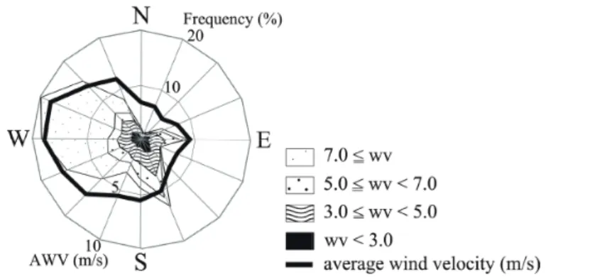
As indicated in Fig. 3, the predominant direction of the monsoon in the Noshiro region is from the northwest to the west. The annual average wind velocity (AWV) is 6.5 m/s (30 m above ground level:
AGL). According to the grain size scale established by Fritz and Moore (1988), this value corresponds with a boundary of the floating and deposition of medium sand (500–250 µm).
Fig. 3 Frequency of appearance and average wind velocity (wv in m/s) of each wind direction at 30 m AGL measured from January to December, 2000 in Noshiro region (NEDO 2006).
The current of the sea and the mouth of river
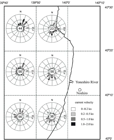
The flow of the current in the Japan Sea has a northward tendency, due to the effect of the warm current from the Tsushima Strait. However, the Japan Coast Guard (Hydrographic and Oceanographic Department of the 2nd regional Japan Coast Guard Headquarters 2012) conducted research using data from the ADCP (Acoustic Doppler Current Profiler) over a period from 2001 to 2008. Their findings suggest that, in a water layer of a depth of less than 10 m on the coast of the
- 4 -
Noshiro region, the current changes from a northward to southward direction with a clockwise rotation, due to the prevention of the Tsushima current that flows northward by the Oga Peninsula (Fig. 4). The direction of the wind and the regional current indicate a southward dominant direction of supplied sand which composes the coastal dune on this coastal area. This tendency could also show an agreement with the period of the Noshiro coastal dune formation (6 to 1 ka) in the Holocene.
Fig. 4 A frequency statistics distribution map of the stream regime around off-Noshiro district. The numbers of observed points are shown in central of each graph. Modified from Hydrographic and Oceanographic Department of the 2nd regional Japan Coast Guard Headquarters (2012).
- 5 -
3. Methods
The topographic maps used in the study were of a scale size of 1/25,000; “Noshiro,” “Moritake,”
“Ugohamada,” and “Ogata” (all maps of Geographical Survey Institute of Japan are measured on 1971). Hamada (location is shown in Fig. 5b) represents the boundary between the morphological characteristics of the northern and southern parts. We researched the internal structure at 3 sites in the northern part: “Asanai-Hokubu” (north of the district of Asanai), “Asanai-Nanbu” (south of the district of Asanai), and “Kurooka-Nanbu” (south of the district of Kurooka), and at 2 sites in the southern part:
“Ashizaki” and “Gomyokou” (Locs. 1 to 5, respectively, in Fig. 5).
The study area of the Noshiro coastal dune from the Yoneshiro river mouth to the northwest of Hachiro-gata reclaimed land, was restricted due to a lack of adequate outcrop (Miyazawa beach as illustrated in Fig. 5b).
To compare layers within the coastal dune, we focused particularly on grain size, sorting, depositional structure, color, and the wet-dry condition of layers in observation.
4. Results
Panoramic shape of the coastal dune by the topographic maps
Focusing on a range of the Noshiro coastal dune in an E-W direction, the southern part (approximately 500 to 1,000 m) is shown to be narrower than the northern part (approximately 750 to 1,500 m) and is slightly higher. As the northern verge contacts the margin of Noshiro city, it is possible that it has been influenced by artificial change.
Field survey
As a result of our field survey, we observed the characteristics of two layers of humic soil, “Ho”
(Locs. 1 to 3) and “Hy” (Locs. 4 and 5). “Ho” is a layer with clear upper and lower boundaries. It is generally 70 cm thick and is highly humified. On the other hand, “Hy” has indistinct upper and lower boundaries. It is generally 20–30 cm thick and is less humified than “Ho.”
On the basis of the above characteristics it is possible to identify the differences in the aeolian sand layers between the northern and southern parts of the dune.
Loc. 1: Asanai-Hokubu (Northern Asanai)
Latitude, longitude, and height are 40°09′09″ N, 140°00′03″ E, and 20–10 m, respectively.
“Hy” dips westward and divides the upper Dy-II from the lower Dy-I.
Loc. 2: Asanai-Nanbu (Southern Asanai)
Latitude, longitude, and height are 40°09′00″ N, 139°59′59″ E, and 30–20 m, respectively.
“Hy” divides the upper Dy-II from the lower Dy-I.
Loc. 3: Kurooka-Nanbu (Southern Kurooka)
Latitude, longitude, and height are 40°07′45″ N, 139°59′12″ E, and 40–10 m, respectively.
“Hy” divides the upper Dy-II from the lower Dy-I.
Loc. 4: Ashizaki
Latitude, longitude, and height are 40°04′44″ N, 139°57′16″ E, and 40–10 m, respectively.
- 6 -
The southern part of the Noshiro coastal dune consists of five units: Do, Ho, Dy-I, Hy, and Dy-II in the ascending order. Dy-I is divided into two sub-units by another younger humic soil layer (Hy’; Fig. 6).
Loc. 5: Gomyokou
Latitude, longitude, and height are 40°03′47″ N, 139°56′56″ E, and 50–10 m, respectively.
As in the case of Ashizaki, the units are as follows: Do, Ho, Dy-I, Hy, and Dy-II in ascending order. Dy-I is divided into two sub-units by another younger humic soil layer (Hy’; Fig. 6).
The points for discussion focus on that the thickness of Dy-I, although observed at all sites, is thicker in the northern part than in the southern part of the Noshiro coastal dune and that there are more layers in the southern part of the Noshiro coastal dune than in the northern part and changes exist in the thickness of each layer within an outcrop.
Fig. 5 The map of study area. The northern part is shown in (a) and the southern part is shown in (b) based on 1/25,000 scale map of Geographical Survey Institute of Japan, “Noshiro,” “Moritake,”
“Ugohamada,” and “Ogata” measured on 1971.
(a)
(b)
T.N
- 7 -
Fig. 6 (a): Photograph of landscape at Loc. 4 (May 2, 2011), and (b): description at Loc. 4.
5.Discussions
Both the morphological characteristics and the number of units composing the layers of the dune, illustrate that northern and southern parts of the Noshiro coastal dune are bound together around Hamada of which location is shown in Fig. 5b. Three layers from the northern part, (Dy-I, Hy and Dy-II), coincide with the upper three layers in the southern part. The structural difference has been explained by a crustal tilting to the northeast (Shiraishi 1990).
However, the upper boundary of Dy-I in the northern part is generally higher than that in the southern part. It is therefore evident that another factor was involved in the differences of forming between the northern and southern areas.
If we refocus on the topographical characteristics, it would appear that the sedimentary supply from the beach differs between the two areas. The Yoneshiro River, the mouth of which is located at the northern end of the study area, supplies most of the detrital grains to the Noshiro coastal dune. The estimated direction in which detritus is transported along the coast also suggests the possibility that deposits have been transported southward. The results of a grain size analysis of the Noshiro coastal dune and coast also reveal the tendency of southward sand grains transport from the river mouth of the Yoneshiro River, which were major components of the Noshiro coastal dune (Utsugawa 2012MS). Thus, it is easy to presume that a decrease in the supply of beach deposits of which the coastal dune is composed, with a southward, longshore current influence, decreased the thickness of Dy-I from the direction of the northern part to the southern part.
(a)
(b)
- 8 -
According to the internal structure observed at both southern sites (Locs. 4 and 5), the presence of another younger humic soil layer (Hy’; Fig. 6) is detected above the known younger humic soil layer (Hy;
as referred to above with other three units, Fig. 6). Thickness of the sand layer (Dy-I), thinning and partial amalgamation of upper and lower humic soil layers were observed, specifically at the Ashizaki site (Loc.
4). On the basis of the change in thickness and internal structure of Dy-I, we infer that swarm of small dune bodies existed during the Dy-I forming period in the southern part. It is known that barchans are formed in areas where sand supply is limited and where winds are almost unidirectional (e.g., Taniguchi et al. 2011). As previously mentioned, sand supply in the study area decreases from the northern to the southern part and, for this reason, it is possible to estimate that complex barchans were formed as illustrated in Fig. 7 at the southern part of the Noshiro coastal dune. Barchans have been reported in the coastal dunes of the shorelines of Japan at the Teshio coastal dune (Segawa et al. 1984), and the Enshunada coastal dune (Matsukura 1977). From topographic maps of the study area, barchans-like landforms elongating their horn eastward are identified (Fig. 5). Barchans advance in the predominant direction of the monsoon (i.e., the direction which sand transports), so we also infer that not only crustal tilting, but also barchans, caused the partially high topography in the southern part.
Fig. 7 (a): The phase diagram of the shapes of sand dunes, reflecting variations in wind complexity (RDP/DP), and (b): schematic diagrams showing typical dune shapes and corresponding wind directions (Taniguchi et al. 2011).
6. Conclusions
A survey using topographic maps and field studies indicated differences between the topographical characteristics and formation processes of the northern and southern parts of the Noshiro coastal dune.
(1) Focusing on a range of the Noshiro coastal dune in an E-W direction, the southern part (approximately 500 to 1,000 m) is shown to be narrower than the northern part (approximately 750 to 1,500 m). (2) The height of the southern parts of the Noshiro coastal dune tends to be higher than that of the northern parts. (3) At northern sites (Locs. 1, 2 and 3), we observed three units (Dy-II,
(a) (b)
- 9 -
and Dy-I), on the other hand, we observed 5 to 7 units (Dy-II, Hy, Dy-I, Ho and Do) at southern sites (Locs. 4 and 5) ; thickness of the Dy-I, thinning and partial amalgamation of upper and lower humic soil layers were observed, specifically at the Ashizaki site (Loc. 4).
In addition to differences being attributed to previous crustal movements causing a northeastward dip, it is evident that there is another factor to consider in explaining the difference between the topographic characteristics. We deduce that a decreasing supply of the beach deposits that supplied sand grains to the coastal dune, caused a change in the formation processes affecting the northern and southern parts of the Noshiro coastal dune. It is possible, therefore, that swarm of barchans formed a complex internal structure in the southern part of the dune. We believe it would be worth evaluating the sedimentary supply and its affect on the formation process of other coastal dunes situated in a longshore direction.
Acknowledgements
We thank Mr. Masahiro Satoh (Shuhoh Corporation), Mr. Hatsuo Makino (MAKINO Ltd.) for support with the field survey; Professor Haruo Yamazaki, Professor Takehiko Suzuki, Mr. Ryo Hayashizaki, Mr. Yasutoki Mukaiyama and other members of the Laboratory of Geomorphology and Quaternary Geology at Tokyo Metropolitan University, for their help during this study.
References
Fritz, W. and Moore, J. 1988. Basics of Physical Stratigraphy and Sedimentology. New York:
Wiley.
Fuji, N. 1975. The coastal sand dunes of Hokuriku District, central Japan. The Quaternary Research 14: 195–220.**
Furuta, N. 2005. Heiya no Kankyou Rekishigaku (The Environmental Historiography of Plain).
Tokyo: Kokon Shoin.*
Hydrographic and Oceanographic Department 2nd Regional Coast Guard Headquarters. 2012.
Frequency statistics distribution map of stream regime around the Noshiro district.
http://www1.kaiho.mlit.go.jp/KAN2/kaisyo/ccr/noshiro/noshiro_t.pdf (November 20th, 2012).
Katsuki, A., Nishimori, H., Endo, N. and Taniguchi, K. 2011. Analysis of barchans dune dynamics using numerical simulations and flume experiments. The Geological Society of Japan 117:
155–162.**
Matsukura, Y. 1977. A study on the aeolian bed-forms in Enshunada beach, Shizuoka Prefecture, central Japan—their configurations and criteria of formation. Geographical Review of Japan 50: 402–419.**
Naruse, T. 1989. Coastal sand dunes in Japan. Geographical Review of Japan 62A: 129–144.**
New Energy and Industrial Technology Development Organization. 2006. Maps of the local area wind conditions. http://app8.infoc.nedo.go.jp/nedo/index.html (November 20th, 2012).
Sato, H. 1994. The relationship between late Cenozoic tectonic events and stress field and basin development in northeast Japan. Journal of Geophysical Research 99: 22, 261–22, 274.
Segawa, S., Fukumoto, H. and Naruse, T. 1984. Formation of ventifacts on the backshore at west coast of Wakkanai in Hokkaido. Geographical Sciences 39(1): 31–36.**
- 10 -
Shiraishi, T. 1990. Holocene geologic development of the Hachiro-gata lagoon, Akita Prefecture, northeast Honshu, Japan. The Geological Society of Japan 36: 47–69.**
Shiraishi, T. 1993. The Holocene development of the coastal dunes, Akita Prefecture, northeast Honshu, Japan. The Japanese Geotechnical Society 41(3): 25–30*
Tamura, T., Kodama, Y., Saitoh, Y., Watanabe, K., Yamaguchi, N., and Matsumoto, D. 2010.
Ground-penetraing radar profile of the Tottori coastal dunes. The Quaternary Research 49:
357–367.**
Taniguchi, K., Endo, N., and Sekiguchi, H. 2011. Morphology and evolution of an isolated sand dune affected by intersection angle of alternating bidirectional flows: results of flume experiments. The Geological Society of Japan 117: 148–154.**
Utsugawa, T. 2012MS. A study on grain size distribution and formation process of the Noshiro coastal dune, Akita Prefecture, northeastern Japan—relationship with the present beach deposits—. Graduation Thesis submitted to the Department of Geography, Tokyo Metropolitan University.**
(*: in Japanese, **: in Japanese with English abstract)
- 11 -