Geomorphic History of the Alluvial Lowland
Related to the Sedimentation and Environmental
from the Soma Coastal Plain
著者
PASHA A.B.M. Kamal
雑誌名
The science reports of the Tohoku University.
7th series, Geography
巻
54
号
1/2
ページ
25-48
発行年
2005
URL
http://hdl.handle.net/10097/45266
25
Geomorphic
History
of the Alluvial
Lowland
Related
to the
Sedimentation
and Environmental
Changes
under
Differing
Relative
Sea Level Regimes
; Examples
from
the Soma Coastal
Plain
A.B.M. Kamal PASHA*
Abstract This paper discusses about Soma coastal lowland with emphasize to
alluvial sequences and sedimentary environments to demonstrate the link
between the evolution of the coastal barrier and evolving nature of marsh
deposits of the back barrier region. It also presents a model diagram of the
Holocene sedimentary structure and sequences of the shallow valley fills in a
marine wave and fluvial dominated setting, based on detailed facies and
chronostratigraphic analyses, grain size analyses and pyretic sulphate — sulfur
(FeS2-S) analyses.
Stratigraphic surveys and sedimentological analyses of coastal sediments
along the Soma coastal lowland in Fukushima prefecture, somewhat reveal that
during the middle Holocene this coast was characterized by barrier spits, open
lagoons and estuaries. These estuarine systems matured during the late
Holocene, with progressive sedimentation and inlet closure leading to the
dominance of back marsh deposits.
This shallow valley in fills has been strongly influenced under differing
relative sea level regimes, in particular on their facies, systems and stacking
patterns. The latest Pleistocene — Holocene deposits beneath the lowland of
Soma coastal plain as sedimentary sequences are divided into the following
categories. (1) The Lower Gravel layer as Basal Gravel (BG) is fluvial in
origin, which were deposited during low stand sea level in the Last Glacial
stage. This Lower Gravel deposits corresponds to braided river systems. (2)
The Lower Terrestrial Sandy (LTS) layer is composed of sandy sediments
which were deposited in fluvial environments during the early transgression
stage and it's characterized by terrestrial flood plain deposits. (3) The Marine
Clayey (MC) layer is composed clay, silt and sand facies with shell and shell
fragments which were deposited in inner bay environments during early
Holocene transgression stage. (4) The Upper Marine Sandy (UMS) layer is
composed sandy sediments with shell fragments including organic materials
which were deposited in shallow marine and lagoon environments as bottom set
deposits ; and (5) The Upper Terrestrial Sandy (UTS) layer is composed of
* Graduate student, Institute of Geography, Grandate School of Science, Tohoku Unicersity,
Sendai 980-8578, Japan
Science Reports of Tohoku University, 7th Series (Geography) Vol. 54, Nos. 1/2, 2005, 25-48
26 A.B.M. Kamal PASHA
sand, silt and clay mixed with small gravel in somewhere including organic
materials which were deposited on the flood plain characterized by pro-grading
sub aqueous delta systems as fore set sediments deposits in the Holocene
regression stage. The upper most position of this layer should be considered as
the back marsh conditions and environments.
Key words : Alluvial lowland ; Geomorphic development ; Back marsh ;
rier ; Relative sea level ; Holocene ; Soma coastal plain
1. Introduction
This study discussing about Soma coastal plain with emphasize to alluvial sequences and sedimentary environments to reconstruct the geomorphic history. The selected coastal plain is defined as lowland generally small and sometimes narrow plain and also possessed the shallow valley. The shallow valley in fill one of the most important indicators of the ancient sea level.
Many studies of the geomorphic development of the alluvial plains in Japan have reconstructed and made many Holocene sea level curves. At present most of the Japanese rivers are meandering consisting of muddy sand and gravel. In the past these rivers were braided consisting sand and gravel during low stand periods of the sea level in the glacial episode, due to steep slopes, short lengths and high water discharges of rivers (Yamamoto, 1988). More over, except for the coast of central Kyushu, the Japanese coasts are micro tidal and wave dominated. Rivers and wave energy are major controlling factors on sediment facies and stacking patterns in the Japanese islands (Y. Saito, 1995). Alluvial plains in the coastal region of Japan are considered to have developed according to following processes : during the Last Glacial stage when the sea level was lowered, rivers dissected their valleys downward to the level. After then, inconsequence of Post-Glacial rise of the sea level these valleys were drowned and filled up with transgression deposits (Iseki, 1975). At about 10,000-9,500 yrs B.P. sea level was positioned at about —40 m relative to its present level. After that period, sea level rose abruptly until about 8,000 yrs B.P. and 8,000-6,000 yrs B.P. when its rate was slowed, sea level reached nearly the present level or some meter higher than at present sea level. Since 5,500 yrs B.P. sea level has been rather stable with slight fluctuations up to the present (Kaizuka et al ., 1977 ; Ma-tsumoto, 1985). Henceforth, the transgression barrier was located seawards on a protruding sector of a coast. This seaward positioned barrier has been matured at the end of the late Holocene period indicated as evolution of the lagoon and marsh deposits.
Regarding this, the author tried to carry out the geomorphic history of the back barrier region sedimentation related to the barrier evolution and its contribution to
Geomorphic History of the Alluvial Lowland 27
coastal environmental management in Soma coastal plain.
In this point of view, the specific aims of this study are :
• To understand and reconstruction the geomorphic history with sedimentary
environmental changes of the study area.
• To demonstrate the link between the evolution of the coastal barrier and
evolving nature of the back barrier region.
• To draw a model diagram of the Holocene sedimentary structure and sequences
of the shallow valley fills in a marine wave and fluvial dominated setting ; and
• To carry out the paleo-environmental changes of the lagoon sedimentation to
back marsh deposits on coastal evolution and stability.
2. Study area and regional setting
The Soma coastal plain of Fukushima Prefecture is located at south-east part of the Tohoku region and north-east part of the Fukushima coastal plain. It is about 9 km long from north to south. This coastal plain extends along the Pacific Coast (Fig.
1).
In general, the beach ridges of the Soma coastal plain are recognized as sandy beaches including small gravel. The coastline is mostly in a micro tidal environment dominated by storm waves on alluvial plains (Koike K. 1977). The Uda and Koizumi rivers flow on this plain. Here, the Koizumi river is a small one but the Uda river is the larger one in the drainage area. The channel lengths and drainage areas of these two rivers are as 10.355 km and 15.4 km' (Koizumi river) and 38.688 km and 86.3 km' (Uda river) respectively. Several alluvial lowlands along the coastline are recognized on the land classification map (Fig. 2). The alluvium is distributed widely in the coastal plain basically along the rivers, forming alluvial plains, like beach ridge, back marsh natural levee, delta and valley floor deposition. It is composed of gravel, sand, silt and sometimes mud also. Thus, this plain consists of such geomorphic units as beach ridges, back marshes, natural levees and lagoon lowlands.
The Soma coastal plain is dominated by the back marsh geomorphic units with the geological settings. The altitude of the most part of this plain is 5 m above from the present sea level and most inner part of this plain stands 10-20 m above the sea level. The inner part is located along the foot of dissected hilly land with of less than 2 km. The northern part of innermost location is about 10 m above the present sea level, while the altitude of southern part of innermost location is about 15-20 m above the sea level. The central part lies after innermost location from inland to seaward with its width and altitude of about 2 km and 2 to 5 m respectively. Outer part goes to along the present coastline where, the width is about 4 km with the altitude of less than 3 m above the present sea level.
28 A B.M Kamal PASHA 41 N an 39 N 98 N ro G cC • 40 .- ;11 -r 5024 'oma -Lid a R 37 Nt — roll.1 11 ^ r."..., - r4r,/7..
139E 140E 101E LI, F‘S,,,,.',..
I'''(4)•-;
Man()R,,,...r,1 Z —.<46-44
1..4....qH
''''-:4NittaFt).
,ett-.-,1'
9‘ ,...
,...4' ..3 =ill:I = - Ota R -Mg tiei.,,,'A
, , 1 ikr, It".'*
::,_-_,4,105-_,--_----.)
v ,Legend %.–, ,,,,-
E Alluvial lowlands2" i, ,.0 R '''IL•11110.• 169••,..fitk-
,n„Liq Terrace, Hills and Namie
"'---J Mountains ''7.
d
piP- ElShelf channelr' - , 0 skm „...,—. -\--, - - -cf9 iHaramachi. O)"()
I=,/
10.
/1"
Fig 1 Index and location map with sub-marine topography of the study area. (Submarine topography after K Yashima et al., 1980)
3. Data sources and methodology
Data sources are divided into two categories, such as (1) Primary data sources as, topographic maps, aerial photographs, detailed field works, investigations and mea-surements, and finally analyses. (2) Secondary data sources as, published documents and unpublished documents.
Reconstruction of the geomorphic history in particularly, stratigraphy and their sedimentary environments of the Soma coastal plain deposits has been performed through detailed field work, systematic interpretation of different scale of aerial photographs and topographic maps, digging the bore holes and analyses of bore hole data and records together with the grain size analyses and pyretic sulphate — sulfur (FeS2-S) contents analyses.
characteris-Geomorphic History of the Alluvial Lowland 29
(a)
LegendFH:13r LIM
F17--C181
---':•;
-4-1;:o...*:::,-:-,
,:
.--.,,,-,-_,
P+4; :.4
Z
., ...400:..i.--',IJ-
r.
1,...AiritlArteA•§:L
.1ii07- 4, II .... .„...44•10. ::::::::, r ig 1.,.
) F
57) sil
,7. 1 U
' / 1 cs, , - . $.4 ,,830•II
,'" i'r''‘
7
1/42....
.. ,
S'_.2 ''''
, • i r•.,•
S13
]ik1
.1-'N'""
?IN'
:.:1**$
`.-4-
--
"..;^••41.1itt*" 4'''' TY1.:1
C44
29,&.,:::::...'. ,--.--. KOC'--"'S :Z, K10V-1 K7i•CO 4 K21.1,,,..., K1 e .:.4'j , _ ... ...-..,... ...,-''_ S28,,,......? 4 4*
qv:v:4;4;3-
aal,
5y.6
g3(61rr
IriP•
S6 824 S25 * S26 C .: S22 620 523 SoIsiTErRA
RIO SOMA 17 B5 0170,74
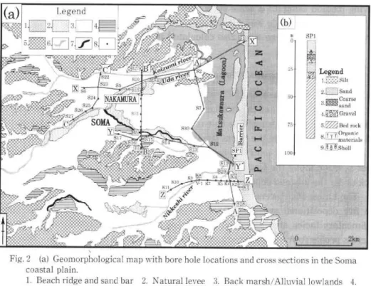
(b) 0, S15 B 50 75 DO SP1 Legend 1.= Silt 2.E]] Sal.' 3.amsCaonadrse 4.McsGravel 5.M Bed rock S' 1/171n2C)ragtaenrijaclsFig. 2 (a) Geomorphological map with bore hole locations and cross sections in the Soma coastal plain.
1. Beach ridge and sand bar 2. Natural levee 3. Back marsh/Alluvial lowlands 4.
Terrace 5. Hills and mountains 6. Rivers 7. Abandoned channel 8. Bore hole
point
(b) Geologic column with sedimentary structure of barrier evolution (modified after
Suzuki et al., 1990)
tics of the land forms and land cover in study area where several alluvial lowlands like , beach ridges, back marshes, natural levees and lagoon lowlands and are concentrated and also tried to understand about geology and soil conditions of the Soma coastal plain.
Extensive field work involved in detailed measuring of coastal processes and identifications of drilling hole points on the topographic maps by the bore hole data and records which have been collected from several organizations (Fig. 2). In order to understand the stratigraphy and their sedimentary environments of the geomorphic development in Soma coastal plain, bore hole records have been analyzed duly . More over, select the position to dig the hole for collect some samples to determine the boundary of the marine and non-marine sediments deposits with the grain size analyses and pyretic sulphate — sulfur (FeS, -S) contents analyses and also to make clear concept about back barrier region sedimentation related to the barrier evolution . Grain size analyses were conducted in the geography department laboratory at Tohoku University. Particularly, grain size analyses were leaded by the conventional
30 A.B.M. Kamal PASHA
sieving method using 0.5 scale sieve interval. 3.0 cb scale and finer side was 4.0 q scale sieve. through 4.0 c6 scale sieve were also calculated
Coarser side of sieve was almost —
Silt and clay materials which passed
in these analyses.
4. Description of data analyses 4.1 Sedimentary sequences
In order to understand the stratigraphy and their sedimentary environments on the Soma coastal lowland, some bore hole records were collected and analyzed duly. The alluvial sequences along the Soma lagoon area is shown in A-A' cross section and B-B' cross section in the central zone moreover C-C' cross section located in the inner most position along the foot of hilly land of this plain (Fig. 2 and 3a, b and c). Bed rock under the lowland deposits composed with Neogene tuff, mud stone and silt stone.
The Latest Pleistocene — Holocene deposits beneath the lowland are divided into the five depositional systems. Each system is characterized by a combination of sedimentary facies, structures and distribution patterns of the deposition. According to cross profile A-A' (Fig. 3a) the lower part of the deposits is gravel bed. This gravel bed is separated by fluvial sand and silt layer. The lower gravel bed composed of medium to coarse sand, cobble gravel and granite gravel. The average size of these gravels are 0.5-7 cm in diameter, some times it's become augmentation as 20 cm in
a.s.1 0 -5 -10 -15 -20 -25 -30 -35 A 528 529 S11 Lis S12 Matsukawa Ura 930 57 S -9„ Fig. 3(a) , :1•1 52 A" \10 Legend 1.1, ‘-] 3 .L:Lj 4 6.SO 7.E3 8 T
3(a) Geological columnar profile coastal plain (A-A').
1. Reclaimed ground 2. Clay 3. Bed rock 8. Organic material 9.
PT-• PT-• `'1M 0 BG km with Silt Shell lithostratigraphic 4. Sand 5. sequences Coarse sand of the Soma 6. Gravel 7.
Geomorphic History of the Alluvial Lowland 31 a.s.1. m 10 0 —5 —1 F. —20 B B1 B2
4-274
B3 B4 B6 B5ÂNB7 Be z 5:635 PPP:. 7.Z1 Lrtitr 89 B10 811 B12 813 :40 Uda F? 818 B17 ITWIN
Legend 2.[ 1 3 5. ozzi TTij 9.1 020 gs5s5s5i5i5.4' 1 :41.4.14141.11.4 B 31416 . ..•B151....1•I.i5i5
vtijtif *B21 32G N1(71 =t==7.)-7= 0111..11s1
S LT 1 823 B222824 B26 44.1825-C Kolzurni R.1
i23 km ,.... Br B27 Zni3: :1;1 1Fig. 3(b) Geologic columnar profile with lithostratigraphic architecture of the Soma
coastal plain (B-B').
1. Reclaimed ground 2. Clay 3. Silt
rock 8. Organic material 9. Shell
4. Sand 5. Coarse sand 6. Gravel 7. Bed
a.s.1. m 15. 10 0 -5 -10 -12 -20 C S27 526 525 S24 LTS S23 :17 S22 C' jC MS 9 km 1.,
Fig. 3(c) Geological columnar profile with lithostratigraphic
coastal plain (C-C').
I. Reclaimed ground 2. Clay 3. Silt
rock 8. Organic material 9. Shell
4. Sand 5. Legend 2.T-1 5Sag 8j7 9.088! sequences of the Coarse sand 6. Soma Gravel 7. Bed
32 A.B.M. Kamal PASHA
diameter but a very few. So, according to Iseki, 1975 ; and Umitsu, 1981, this gravel bed is thought Basal Gravel (BG). Basal Gravel is situated at the base level of this alluvial lowland deposition, for this reason, it's a fundamental deposition of alluvial sequences and environments. This Basal Gravel sediment is interpreted as alluvial-fan-related sediment deposits during the low stand sea level in the Last Glacial stage and it also corresponds to braided river systems.
Just above the gravel bed there is rippled sandy sediments layer. It composed with cross bedded coarse sand to rippled fine sand to muddy and peaty sediments. This layer contains a lot of organic materials but no shell or shell fragments ; thus it considered as Lower Terrestrial Sandy (LTS) sediments deposition on flood plain. The cross bedded to ripple laminated sand facies are interpreted as in channel facies and organic-rich sediment facies are viewed as over bank facies of the meandering river systems in fluvial environments during the early transgression stage and it also characterized by terrestrial flood plain deposits.
Further above, there is thick muddy sediments layer which is subdivided into two parts, as Marine Clay (MC) layer and the Upper Marine Sandy (UMS) layer. Because
of, the MC is mainly composed of silt and clay containing sand facies including huge amount of shallow marine shells and shell fragments which were deposited in the inner bay environments during early Holocene transgression stage. On the other hand, UMS mainly composed with sandy sediments including shell fragments and organic materials together. Thus it should be considered marine and terrestrial environments together and which were deposited in shallow marine and lagoonal environments during Mid-Holocene to Late Holocene stage. According to Fig. 3(a) A-A' cross profile, the UMS layer lies on MC layer but in B-B' (Fig. 3b) cross profile these two layers as MC and UMS are appears like neighbouring position. This valuable infor-mation indicates, the head of the lagoon water body was existed about 5 km inland ward in the north-west zone of this plain from the present shore line during the first half of the Late Holocene period.
The upper and uppermost of the alluvium named Upper Terrestrial Sandy (UTS) layer be composed with sand, silt and terrestrial clay sediments contains a huge amount of plant roots, wood fragments and debris materials and also some times (adjacent of river flow) includes fluvial sand deposits mixed with small gravels in somewhere which were deposited on the flood plain characterized by pro-grading sub aqueous delta and natural levee systems in the Holocene regression stage. The upper most position of this layer should be considered as back marsh conditions and environ-ments.
More over, the cross section C-C' (Fig. 3c) located in the inner position along the foot of hilly land of the Soma coastal plain. According to C-C' cross profile, south located position is about 8 km inland ward from the present shoreline with altitude
Geomorphic History of the Alluvial Lowland 33
about 12 m high from the present sea level while the north located position is about 6 km inland ward from the present shoreline and its altitude about 5 m high from the present sea level. C-C' cross profile also shows, BG gradually become narrow up-ward. There is LTS is visible as thick layer and suggested terrestrial environments which were deposited on flood plain. MC unit is absent in C-C' cross profile and right hand side there is UMS unit is visible which revealed brackish environment deposits. There is thick UTS unit which is characterized by flood plain, river delta and natural levee and the most upper part of this unit corresponds to back marsh deposits.
Therefore, sedimentary sequences are divided into five layers such as BG ; LTS ; MC ; UMS and UTS respectively.
Besides, the cross sections at diagonally to the shoreline are represented in X-X' (Fig. 2 and 4a) and in Y-Y' (Fig. 4b) of Fig. 2. According to Y-Y' cross profile, the inner most position is about 5 km inland ward from the present shore line and its altitude 6 m high from the present sea level, while X-X' cross profile shows the inner most position is about 7 km inland ward from the present shore line and its altitude about 7 m high from the present sea level. Y-Y' cross profile (Fig. 4b) indicates, the depth of BG gradually become narrow inland ward. LTS layer is visible which is revealed terrestrial environments and its thickness is increases land ward. Sedimen-tary sequences of MC and UMS that are marine and brackish facies respectively and the thickness of MC is decreases land ward. On the other hand, in X-X' profile, MC layer is absent. Marine sediments emerge at the depth of about —18-0 m, just below the present sea level (Fig. 4b). UTS layer is visible and the thickness of it increases land ward and influenced to the uppermost surface layer directly. In a contrary
X S6 5 0 -5 -10 -15 •20 sea S5 T rYs-cr&rg: 420 54 s2 Mateukawa Ura X sl /h //s.4g. "1(7\0 km k l.hr 4.[M] 6.§E 7.m &HT! 9,[6.6
Fig. 4(a) Geological profile with lithostratigraphic sequences of the Soma coastal plain (X-X').
1. Reclaimed ground 2. Clay 3. Silt 4. Sand 5. Coarse sand 6. Gravel 7. Bed rock 8. Organic material 9. Shell
Legend 2 3.k:A 5.03A. 6.§E 8.1 I 7 9.1 e °
34 A.B.M. Kamal PASHA a .s.1 10 5 0 -5 -10 -15 -20 -25 30 Fig. 4(b) (Y-' 1. R 8. C Y S17 . _ S16 IT4 S15 WWW" • , _ _ `../7/7;•/7//, S14 ;41 t TS 511 Legend rr 2.1 6.nti 8.1° el 0 1. I 41111] Matsukawa Ura
S12,;
S11 Y /// Otl4(b) Geological profile with lithostratigraphic sequences of the Soma coastal plain
Reclaimed ground 2. Clay 3. Silt 4. Sand 5. Coarse sand 6. Gravel 7. Bed rock
Organic material 9. Shell
manner, upper most terrestrial sediments gradually become narrow sea ward and marine sediments gradually decrease land ward. So, according to the stratigraphic sequences, it decided that the sediment structure is thick at one end and thin at the other, like wedge shape between terrestrial and marine sediments.
Besides, in particularly bore column as SP1 (Fig. 2b, after Suzuki et al., 1990) records shows while the barrier was positioned seawards on a protruding sector of a coast the bed rock was situated 30 m below the present sea level. According to lithostratigraphic sequences of this hole, the barrier of Soma coast developed with coarse grained sediment. Just above the bed rock there is gravel bed which is called beforehand as Basal Gravel (BG) that fluvial in origin and were deposited during low stand sea level in the Last Glacial stage. This BG deposits also corresponds to braided river systems. Above this BG deposits there is Lower Terrestrial Sandy
(LTS) layer which were deposited in fluvial environments during the early transgres-sion stage and it characterized by sub aerial delta formation. After then, the further above there is estuary mouth sand bodies which were deposited as barrier spit in the middle Holocene period. This layer composed with gravel mixed sand and silt includ-ing shell and shell fragments and thus it posses the marine environment (marine in origin). The upper layer of this hole is composed of sandy sediments including very small gravel. This layer was deposited as some times tidal delta by transgressive dunes and accelerate to development and maturity of the barrier evolution in the Late
sedi-Geomorphic History of the Alluvial Lowland 35 a.s.1. cm 100 0 -100 -200 -300 z K11 z 'egend
1Y
y
YI
6 0 6
a
0 -400Fig. 5 Geologic columnar profile with lithostratigraphic architecture of the back barrier
region deposits in Soma coastal plain (Z-Z').
1. Reclaimed ground. 2. Clay. 3. Sand. 4. Coarse sand. 5. Organic material. 6.
Shell. 7. Assumed bottom line of the back marsh deposits.
ments covered with Aeolian sandy deposition, consequently, it express the degree of shoreline stability.
Moreover, look at the coastal records from one site of Soma coastal plain (Fig. 5 and Z-Z' of Fig. 2). Bore holes in the low lying areas behind the coastal barrier and it revealed, consisting of multiple inter bedded layers like inter fingering deposition of biogenic sediments and sand. Bore hole stratigraphies are illustrated in Fig. 5 (Z-Z'). The samples transect perpendicular to the shoreline in south area of the Soma coastal plain. Z-Z' cross profile shows, the upper sediment is clay facies including organic materials. Just below this layer, middle to right hand side of this profile there is sand facies. The author assumed that this sand layer was deposited under terrestrial environments. After then, to downwards the sedimentary sequences are consisting of multiple inter bedded layers of biogenic sediments and sand deposition. This profile also indicates that the total amount of sand decreases overall landward and sand bed are confined in extent to the barrier ward.
4.2 Grain size analyses
A variety of techniques were applied at the site in order to examine the
a.s.1. cm 50 0 -50 -100 -150 -200 -250 -300 -350 -/00 -450-V.Loc. 0 0.5 1.0 1.5 211 Silt and ^Thdy%:0.81 2.0 2.5% 20 K8 55.111.; to 15 10 25 c 20 ^ 10 ;10
8
5
0 Silt and clav%:0. 95 Somal_;-1mran standard skewness
0_ 47C dpvi, on J.084 -0 IHM -1 -3 -2 -I 0 I 2 3 4 diameter( 0) Silt and clay%,2.80 SrrmaG• I moan ::t ttnda r4 2.071 0.810 1.730 G-1 G-2 G-3 • -4 3 2 -I 0 1 2 3 4 diameter( ) Silt and c• I av*.: 1. 12 50 25 O20 On a1 3 s Il 25 ‘89,20 415 00 • <7.), s S2 • -G-4 -G-5 S 3 • G-6 100 Mean 2 1.5 1 diameter 0.5 0 -0. 0 -14,
SomaG-2 me.an stunduld
deviation 1.924 1.240 -1..42 S4 • S5 • 25 20 415 .ib105 a 5 0 0 0.5 1.0 1.5 (a) 4 -3 -2 -I 0 I 2 3 4 diameter( ) Si]l 01111 1.1,11/ 0:0. 71 Soma[;-0 enn 51,3,031 Soma6-3
meah standard skowneas
2. 01.17 (I0A.J At iuu 102 150 -4 -3 -2 1 0 1 2 3 4 diameter( Sill and clay%:2. 01 200 25 -:7P, .4 t oz. ' 10 5 0 250 1.72C d,wiation 0.991 -1.213 tiomal,fi mean Aatidard okeullesN
1.012 deviati., I. r2S -0 .9N 300 •I . 924 • I . 726 • 2.071 a 2. 037 •1.612 •0.470 0 Standard 0.5 den i or 1. 5 20 50 • 100 l50 200 250 300 0. 84€ 11., 88,1 1.248 • 0.990 1 ..4t4 • 1.102 I. 123 • , . -4 -3 -2 -1 0 1 2 3 1 43-21i I1I [• diameter( ¢ )diameter( 6)350 - 350 - cm cm (b) Grain size distribution. Grain size analysis was operated from -3.0 to 4.0 phi. Mean, standard deviation and skewness was calculated. 4111 The frequency of fine sediment , silt and clay are indicated on the roof of these figures as weight %. ,,,,,,, 2.0 2.5% Legend I . / ••12. „•I:3_:..:: - ,, 4B17:7...1:4,!,( 7,.,1 '::•::?..5...9.5-Y 61 Fig. 6 Geologic column of the sampling sites and results of the FeS2-S contents analyses and grain size analyses. FeS2-S contents analyses, (b) Results of the grain size analyses. 1. Reclaimed ground 2. Clay 3. Sand 4. Coarse sand 5. Organic material 6. Shell (a) Results of the Cf) P-c
Geomorphic History of the Alluvial Lowland 37
the process of sediment deposition. The lithostratigraphy was initially explored by hand coring, using hand hold gouge auger ; and also using percussion instruments with vibra coring.
In order to understand the sedimentary environments and to distinguish the marine and terrestrial sediments, grain size analyses were conducted. Grain size analyses were carried out by the conventional sieving method, using 0.25 ch scale sieve interval. Coarser side of sieve was almost —3.0 q scale and finer side was 4.0 ch scale. Silt and clay materials which passed through 4.0 q sieve were also calculated in this analyses (Fig. 6, core no. K8-V.loc. as location Gl-G5 top to bottom wards).
According to the results of grain size analyses as sample locations are G-1 ; G-2 ; G-3 ; G-4 ; G-5 and G-6 respectively (Fig. 6). G-1 sand facies are coarse grained sediments as poorly sorted and assumed fluvial in origin. G-2, G-3 and G-4 are considered relatively well sorted as medium to fine and very fine sand respectively. Here, G-2 and G-3 located sand facies are marine in origin contains brackish shell fragments and organic materials together which were deposited lagoon bottom area near the river delta reworking by fluvial activities. G-4 is considered as fluvial and Aeolian in origin and it also deposited in lagoon bottom area under brackish condition. Further, G-5 is considered as not well sorted medium to very fine sand which is also indicates fluvial and Aeolian in origin ran into lagoon area and deposited. Lastly, G-6 is indicates poorly sorted medium to fine sand which is marine in origin and deposited under brackish water environments.
4.3 FeS2-S contents analyses
In order to confirm the sedimentary environments of the deposits FeS2-S contents analyses were also conducted from five locations like S1 to S5 (top to bottom wards) as Fig. 6. According to results of FeS2-S contents analyses it revealed that all the samples including have a lot of S contents. This is why it should be considered that the deposition were marine in origin.
5. Results and discussion
5.1 Paleo-environmental changes
5.1.1 Valley sedimentation (about 10,000-6,000 yrs BP)
According to S. Fujii and N. Fuji, 1967 considering stratigraphy, radiocarbon dating of ancient organic materials lived in near shore and fluctuations of climate, Post glacial sea levels in the Japanese Islands are divided into four phases as following.
The first phase is about 18,000 to 6,000 yrs B.P. and is characterized by a conspicu-ous rising of the sea level which rises from about 130 m below the present one to several meters above the present sea level. But a few stagnation of the sea level are
38 A.B.M. Kamal PASHA
found in it, especially about 40 m below the present sea level while it was about 10,000 yrs B.P. The second phase is about 6,000 to 3,000 yrs B.P. and is one of the high sea levels, which is several meters higher than the present sea level. The third phase is about 3,000 to 1,500 yrs B.P. and one of the low sea levels which is a few meters lower than the present sea level. The fourth phase is after 1,500 years B.P. and sea level rises again to the present sea level.
The coast of Soma in Fukushima prefecture has existed in the Holocene certain environmental conditions conducive to the formation of both transgressive and regres-sive sequences. In general, the former reflects processes operating under conditions of rapid sea level rise, while the latter has occurred since the termination of the Postg-lacial Marine Transgression. Holocene sediments consisted of sands, silts and clays associated with a barrier and back barrier depositional environment.
This shallow valley in fills has been strongly influenced under differing relative sea level regimes, in particular on their facies, systems and stacking patterns. The latest Pleistocene—Holocene deposits beneath the lowland of Soma coastal plain as sedimen-tary sequences are divided into the following categories. (1) The Lower Gravel layer as Basal Gravel (BG) is fluvial in origin, which were deposited during low stand sea level in the Last Glacial stage (Iseki, 1975). The huge accumulation of gravel as the Basal Gravel deposits might have been brought on by the overloaded streams which carried much detritus as the production of the strong physical weathering under glacial or peri-glacial conditions in the upland. This Basal Gravel deposits indicate probably somewhat long transportation by the river and this fact suggests more powerful fluvial action of the days than that of present. This Lower Gravel deposits corresponds to braided river systems. (2) The Lower Terrestrial Sandy (LTS) layer is composed of sandy sediments which were deposited in fluvial environments during the early trans-gression stage and it's characterized by terrestrial flood plain deposits. (3) The Marine Clayey (MC) layer is composed clay, silt and sand facies with shell and shell fragments which were deposited in inner bay environments during early Holocene transgression stage. (4) The Upper Marine Sandy (UMS) layer is composed sandy sediments with shell fragments including organic materials which were deposited in shallow marine and lagoon environments ; and (5) The Upper Terrestrial Sandy (UTS) layer is composed of sand, silt and clay mixed with small gravel in somewhere including organic materials which were deposited on the flood plain characterized by pro-grading sub aqueous delta systems in the Holocene regression stage. The upper most position of this layer should be considered as the back marsh conditions and environments.
The sedimentary sequences are considered to have been deposited in the following background. First appearances of past sea area in this region is evidenced in the
(a)
• 7~- 4; etal:#4 • • I I 4, • ,„„4.4 • . • • " 4.0 _ Ar,"/4151.11tir(b)
Ar'e Reef Reef a) EMBAYMENT FILLING DURING POST GLACIAL MARINE TRANSGRESSION(c)
or. : • : • 4,• : • • • : : •>:•
• • . • C.:Cd 20 (h) BARRIER POSITIONED AND GROWING DURING EARLY STIT,I,STAND (c.) EQUILIBRIUM ESTABLISHED IN LATE STILLSTAND c./D 10 1) -10 -20 -30 -40(d)
First phase 10.001) - 6,000 yr BP Second phase 6,000 - 3.000 BP Third phase 3,000 - 1,500 BP After,S. Fujii and N.Fuji (1967) Fourth phase 1.500 -present ..L „ , ,444 arlr. - - Endo et. al., (1989) — Sakaguchi et. al.,(1985 - Fujii and Fuji (1982) Koba et. al., (1982) — Matsumoto (1981) (d) Various types of relative sea-level curve in Japan. (after,Masatomo UMITSU,1991). CD 0 O 1=1*1 ‘-< O (5 it '53 a Q. 10 9 8 7 6 AGE( 5 4 x 10³ yr BP) 3 Fig. 7 The model related to the development of a prograded barrier spit and Holocene and it also depicting possible directions of shoreline changes. 2 1 0 associated patterns of sediment accumulation in the40 A.B.M. Kama' PASHA
present sea level. According to further transgression, depositional site of each layer has been changed their position land ward with preservation of its horizontal allot-ment.
At the period when the sea level was 40 m below the present one, transgression started but in Soma coastal plain while the sea level was 30 m below the present sea level the shore line was located near the present one along the Matsukawa (Soma) bay. At the period of —25 m sea level, the sea area expanded further west ward in the central part and it reached to the place about 3 km inland ward (Fig. 3a) from the present shore line. At the following period of —20 m sea level, the transgressive sea water expanded further more trend to north ward from the central part (Fig. 4b). While the sea level was —10 m below the present one, most of the lowland of Soma plain was submerged and transgressive sea water expanded and occupied all the lowland area (Fig. 3b and 7a), resulting ; formed a big bay which reached about 10-km inland ward from the present shoreline in the northern part and about 5 km in the southern part of this plain. When the sea level rose about 5 m below the present level, it assumed that the landward transgression was terminated and shoreline began to recede against the continuing rise of sea level (Fig. 3b and 3c).
The first stage (a) of Fig. 7 is represented by a succession of landward migrating shorelines accompanying the Postglacial Marine Transgression. Buried lagoonal deposits shows that embayment inundation may have began approximately 9,500-10,000 yrs ago with a relative sea level —30 m. This stage is represented stratigraphic ally by the accumulation of lagoonal clays obtained from marine source and reworked sands derived from the inner shelf. The sands were swept both landwards into lagoon and upwards across rising sand surface (Fig. 4b).
5.1.2 Barrier evolution (about 6,000-3,000 yrs BP)
Based on limited data availability this study can not attempt to answer the question as to the genesis of barrier clearly, along the coast of Soma in Fukushima prefecture. The coast of Soma is an embayed bed rock coast with drowned shallow valleys in filled to varying degrees with Quaternary sediments. Two morphological provinces (Fig. 3a) form the framework within which Holocene deposition has taken place. In Soma coast, a subdued bed rock relief is associated with relatively narrow embayment and shallow bed rock headlands. Only Holocene barrier occur within this embayment. The approximate position of the shelf edge is indicated in Fig. 1 (after K. Yashima et al.) by 5 m interval contour line. The submarine slope is about 1/40 to a seaward distance of 450 m from the shoreline and about 1/130 further out ; and submarine contours deeper than a water depth of 5 m run nearly parallel to the shoreline (K. Horikawa and T. Sunamura, 1967). According to bore column as SP1 (Fig. 2b) record shows while the barrier was positioned seawards on a protruding
Geomorphic History of the Alluvial Lowland 41
sector of a coast the bed rock was situated 30 m below the present sea level.
The Holocene barrier is existed and as is well shown in Soma coastal plain by its narrow width about 600 m in the south side and it become gradually narrow towards the north as about 250 m wide. It is about 9 km long from north to south (Fig. 2).
Firstly, at about 10,000-9,500 yrs BP sea level was positioned at about —40 m relative to its present level (Fig. 7d). After that, sea level rose abruptly until about 8,000 yrs BP and 8,000-6,000 yrs BP when its rate was slowed, sea level reached nearly the present level or some meter higher than at present sea level. Since, 5,500 yrs BP sea level has been rather stable with slight fluctuations up to the present (Kaizuka et al., 1977 ; Matsumoto, 1985). The culmination of the Holocene transgression was achieved at about 6,000 yrs BP with sea level approximately nearly the present level or some meter higher than at present. At that time, the transgression barrier was positioned seawards on a protruding sector of a coast (Fig. 7b).
Secondly, after 5,500 yrs BP while sea level was rather stable or despite a general small fall as sea level oscillations, the barrier was subjected to long-term erosion caused by the focusing of wave energy on this protruding sector of a coast. During this erosional interval the barrier somewhat receded and large amount of sand were transported landwards by the transgressive dunes leading to the silting of the back barrier lagoon and as a result, tidal delta has been formed. Depositional sequences which constitute sand barriers form two basic types : transgressive and regressive (Kraft and John, 1979). These two types express the degree of shoreline stability in the long term, for instance during the mid to late Holocene. Transgressive and regressive stratigraphies represent two contrasting modes or styles of sedimentation. Each mode represents a distinctive balance between three fundamental forces control-ling shore face sedimentation ; these are relative changes in sea level, rate of sediment influx from whatever source and rate of dissipation of wave and tidal energies. Unless the input of sediment is very high, it is unlikely that shoreline pro-gradation will occur during the high rates of relative sea level rise which occurred during the early Holocene.
Stage (b) in Fig. 7 reflects the period following the termination of the Postglacial Marine Transgression approximately 6,000 yrs ago. It is suggested that onshore sediment transport during the transgression gave rise to a local abundance of sand. The compartmental nature of embayment indicates limited alongshore bypassing or leakage of sand at this time, whilst river sands were trapped in relatively deep estuaries. Beach ridges formed as a result of sediment transfer from near shore to beach face therefore gently steeping the near shore gradient in order to establish an equilibrium condition.
42 A.B.M. Kamal PASHA
5.1.3 Back barrier region development (about 3,000 yrs BP - present)
The presence of sand layers interleaved with biogenic material in coastal sedimen-tary sequences from back barrier areas has often been used as evidence of storm surge or tsunami action during Holocene (C. Delaney, 1995). Detailed examination of sand layers indicates that while some of the sand beds were deposited by over wash , other process including Aeolian deposition and fluvial reworking of Aeolian sediments were also important in sand distribution in the back barrier areas of the Soma coastal plain. Here, noted that the Aeolian sediments did not count in this study. In these cases , local controls including area drainage characteristics, barrier morphology and avail-able sediment supply, appear to have been important in site evolution.
The effect of storm action on a coast line may involve a complex pattern of sediment redistribution and may be controlled by numerous factors in addition to storm intensity, including changes of relative sea level ; the volume of sediment
available ; tidal regime ; coastal and offshore morphologies ; anthropogenic influences and aspect. Information on Soma coastal plain of these responses may be contained within the stratigraphic record at sites which have been continually exposed to high-energy storms. In particular, a record of the movement of sand onshore may be preserved in the sedimentary sequences. In many locations worldwide such events, represented by, for example, the presence of marine sands inter bedded with fresh water sediments have been used as an indicator of storm surge or tsunami deposition (Dawson et al., 1988 ; Culling ford et al., 1989 and Fearn, 1993).
The lithostratigraphic records from one site of the Soma coastal plain (Fig . 5 and Z-Z' of Fig. 2) bore holes in the low lying areas behind the coastal barrier and it revealed, consisting of multiple inter bedded layers like inter fingering deposition of biogenic sediments and sand. Examinations of the sand layers were under taken in more detail in order to aid identification of the process which led to the movement of sand in the back barrier environments (Fig. 6).
Consequently, according to stratigraphic condition of the profile (Fig. 5, Z-Z') and the results of grain size and FeS2-S contents analyses (Fig. 6) it can be considered that these lithostratigraphic sequences were deposited under brackish water to fresh water condition by wash over storm surges, inlet intrusion of marine sediments reworking by fluvial activities and/or, fluvial sediments interaction while the barrier was located on protruding sector of a coast during the first half of Late Holocene period. Thus, back barrier region were developed as well as back marsh deposits were formed after termination of wash over and inlet intrusion of marine sediments while the barrier evolution was ceased.
Regarding this, the final stage (c) of Fig. 7 is represented possible directions of shoreline changes. This situation appears characteristics of the late Holocene, approximately 3,000 yrs B.P. This situation reflects maintenance or preservation of
Geomorphic History of the Alluvial Lowland 43
a steady-state condition of relatively shallow equilibrium near shore profile compared
to early still stand conditions. In the late Holocene sediment losses are balanced by
sediment gains in the near shore zone. It is assumed that certain embayment with
prograded barrier spit had achieved this condition approximately 3,000 yrs ago and
also revealed that at that time the barrier evolution was ceased.
6. Sedimentation model of the barrier bound Soma coastal plain
Dalrymple and co-workers (1992 and 1994b) defined an estuary from a sedimentological view point as the seaward portion of a drowned valley system which receives sediments from both fluvial and marine sources and which contents facies influenced by tide, wave and fluvial processes. They also showed that evolutionary aspect of coastal environments can be portrayed by relative time with reference to changes of relative sea level and sediment supply (i.e., transgression and pro-grada-tion). The Soma coastal region is defined as micro-tidal wave and fluvial dominated setting. Because of, most of all sediments were supplied from marine and fluvial sources. Anthropogemc
Legend
3M
81. 9•
EN
11.M 12.
_ad
13.FM
Fig. 8 Sedimentatio model of the barrie
wave and fluvial dominated setting.
1. Reclaimed gr2.Silty-clay3.
Sandy silt 5. Sandmixedsiltandclay
and muddy to peatysediments7. Sort
sand 9. Coarsesand10.Gravelly sar
13. Bed rock Subaerialeffect deltaBack Prograding riverdeltaBarrier •Remain deposits .water marsh Estuary mouth sand body body lagoonStrand spit plain
rar,EL/11
Sea level Lagoonal •?e",,e5:,•deposits
Shoreface : !3.0, • 41.Tid al delta • g *-W ave ravinn°
*:41':6:?.=
=
=surface
QQp,•;,-- __ ... • :Marine fi 'I • N0aA 617°•414 NOTE:ao * *13P. g*Fluvial BG: Basal Gravel.LTS: Lower Terrestrial Sandy deposits.
Mc: Marine Clayey deposits.
UMS: Upper Marine Sandy deposits.
UTS: Upper Terrestrial Sandy deposits.
nmodelofthebarrier bound Soma coastal plain in a micro tidal
ound
dominated setting.
)und 2. Silty- clay 3. Organic-rich sand, silt and terrestrial clay 4.
nd mixed silt and clay 6. Cross bedded coarse sand, ripple fine sand
?:aty sediments 7. Sorted fine to medium sand 8. Medium to coarse
44 A.B.M. Kamal PASHA
The sedimentation model along the axis of wave and fluvial dominated estuary is summarized in Fig. 8. The shallow valley fill is composed of sediments of Basal gravel (BG) ; terrestrial flood plain deposits (LTS) ; an inner bay and estuarine infill (MC) which subdivided to sub aerial delta ; central basin (UMS) which is subdivided in to estuarine mud deposits, lagoonal deposits and upper terrestrial sandy deposits which is sub divided in to pro-gradation river delta systems, natural levee and finally back marsh deposits in some where. An estuary mouth sand body which is subdivided in to tidal delta and strand plain-shore face systems.
However, the shallow valley fill of Soma coastal plain shows apparent fluvial aggradation with back stepping during a rapid rise of sea level.
According to above described sedimentation pattern, the author has drawn two models of the barrier bound Soma coastal plain in a micro-tidal wave and fluvial dominated setting as Fig. 7 and 8. These Figures also show the paleo-environmental changes of the lagoon sedimentation to back marsh deposits on coastal evolution and stability.
7. Conclusions
The Soma coastal plain consists of such geomorphic units as beach ridge, back marsh, natural levees and lagoonal lowland deposits. This plain is characterized by active marine sand influx in to the estuary, some times through tidal inlet intrusion of marine sediments and wash over sediment flux reworking with fluvial processes during transgression to a pro-graded barrier sometime after the high stand. This change resulted from strengthening of the long shore supply of sediments from the further south cliff coast of Fukushima coastal region and weakening of cross barrier tidal fluxes in to the infilling interconnected estuarine-lagoonal systems on this coast. This barrier has since closed of the estuary mouth, precluding the influx of flood delta sands in to the central basin. The cessation of active marine sand supply to the central basin has meant that infill during the high stand has been assured solely by fluvial sediments.
The following conclusions are drawn from this study.
(1). Stratigraphic surveys and sedimentological analyses of coastal sediments along the Soma coastal plain reveal that during the middle Holocene this coast was characterized by barrier spit, open lagoon and estuaries. These estuarine systems matured during the late Holocene, with progressive sedimentation and inlet closure leading to the dominance of back marsh deposits.
(2). The high stand sedimentation pattern in the Soma coastal plain has thus been characterized by two distinct sediment suites, with limited admixture : (1) The marine-derived inner bay and estuarine infill and estuary-mouth sand body ; (2) the
Geomorphic History of the Alluvial Lowland 45
heterogeneous back barrier suite of upland derived organic sediments that are present-ly infilling the lagoon basin.
(3). This shallow valley fills has been strongly influenced under differing relative sea level regimes, in particular on their facies, systems and stacking patterns. The Latest Pleistocene-Holocene deposits beneath the lowland of Soma coastal plain as sedimentary sequences are divided in to the following five depositional patterns : (1) The Lower Gravel layer as Basal Gravel (BG) is fluvial in origin, which were deposited during low stand sea level in the Last Glacial stage (Iseki, 1975). The huge accumula-tion of gravel as the Basal Gravel deposits might have been brought on by the overloaded streams which carried much detritus as the production of the strong physical weathering under glacial or periglacial conditions. This Basal Gravel deposits indicate probably somewhat long transportation by the river and this fact suggests more powerful fluvial action of the days than that of present. This BG deposits corresponds to braided river systems. (2) The Lower Terrestrial Sandy (LTS) layer, which were deposited in fluvial environments during the early transgres-sion stage. (3) Marine Clay (MC) layer, which were deposited in inner bay environ-ments during early Holocene transgression stage. (4) The upper marine Sandy (UMS) layer, which were deposited in shallow marine and lagoon environments and (5) The Upper Terrestrial Sandy (UTS) layer, which were deposited in the Holocene regression stage. The upper most position of this layer considered as the back marsh deposits .
(4). Back barrier sediments were deposited under brackish water to fresh water condition by wash over storm surges, inlet intrusion of marine sediments reworking by fluvial activities while the barrier was positioned and located on protruding sector of a coast during the mid to late Holocene period. Thus, back barrier region were developed as well as back marsh deposits were formed after termination of wash over and inlet intrusion of marine sediments while the barrier evolution was ceased.
According to above described sedimentation pattern, the author has drawn two models of the barrier bound Soma coastal plain in a micro-tidal wave and fluvial dominated setting as Fig. 7 and 8. These Figures also show the paleo-environmental changes of the lagoon sedimentation to back marsh deposits on coastal evolution and stability.
Acknowledgement
This research work has been completed under direct supervision of honourable professor Dr.
Toshifumi IMAIZUMI, Department of Geo-environmental Science, Institute of Geography at Tohoku
University. I wish to express my deepest sense of gratitude to him for his indispensable guidance ,
encouragement, keen interest, affectionate behaviour, fruitful suggestions and constant advice in the
whole research period. I Iike to pay my indebtedness honour and gratitude to Dr. Hideaki
informa-46 A.B.M. Kamal PASHA
tion to progress this research work.
I am also extremely grateful to Dr. Masateru HINO, Professor of Human Geography, Tohoku
University, for his kind sympathy, encouragement and inspiration during this research work.
convey my heartful thanks to Dr. Kiyotaka SAKAIDA, Professor of climatology, Tohoku University,
for his valuable suggestions and encouragement during my whole study period.
References
A. Amorosi, M.C. Centineo, M.L. Colalongo, G. Pasini, G. Sarti and S.C. Vaiani (2003) :
Facies Architecture and Latest Pleistocene-Holocene Depositional History of the
Po Delta (Comacchio Area), Italy. The Journal of Geology, Vol. 111, 39-56.
Andre C., Freitas M.C., Moreno J. and Craveiro S.C. (2004) : Stratigraphical evidence
of Late Holocene barrier breaching and extreme storms in lagoonal sediments of
Ria Formosa, Algrave, Portugal. Marine Geology, 210, 339-362.
AKIRA MANO and SHIGEYA SUZUKI (1999) : EROSION CHARACTERISTICS OF
SEA CLIFF ON THE FUKUSHIMA COAST. Coastal Engineering Journal, Vol.
41, No. 1, 43-63.
Allen, G.P., and Posamentier, H.W. (1993) : Sequence stratigraphy and facies model of
an incised valley fill : The Gironde Estuary, France. Jour. Sed. Res., 63, 378-391.
Catherine Delaney and Robert Devoy (1995) : Evidence from sites in Westurn Ireland of
late Holocene changes in coastal environments. Marine Geology, 124, 273-287.
Dalrymple, R.W., Zaitlin, B.A. and Boyd, R. (1992) : Estuarine facies model :
ptual basis and stratigraphic implications. Jour. Sed. Petrol., 62, 1130-1146.
EDWARD J., ANTHONY, LUCIEN M. OYEDE and JACQUES LANG (2002) :
mentation in a fluvially infilling, barrier bound estuary on a wave dominated, micro
tidal coast : The Oueme River estuary, Benin, West Africa. Sedimentology, 49,
1095-1112.
Ervin G. Otvos (2005) : Validity of sea-level indicators : A comment on "A new
positional model for the buried 4000 yr BP New Orleans barrier : implications for
sea-level fluctuations and onshore transport from a nearshore shelf source" by F.
W. Stapor and G.W. Stone {Marine Geology 204(2004)215-234}. Marine Geology,
217, 177-187.
ENDO, K., SEKIMOTO, K. and TAKANO, T. (1982) : Holocene Stratigraphy and
Paleoenvironments in the Kanto Plain, in relation to the Jomon Transgression.
Proceedings of the Institute of Natural Sciences, College of Humanities and
Sciences, Nihon University, Earth Science, No. 17, 1-16.
Frank W., Stapor Jr., and Gregory W. Stone (2004) : A new depositional model for the
buried 4000 yr BP New Orleans barrier : implications for sea-level fluctuations and
onshore transport from a nearshore shelf source. Marine Gelogy, 204, 215-234.
Iseki, H. (1975) : On the basal gravel beds of the recent deposits. Journal of Geography
(chigaku Zasshi), 84, 247-264.
FUJII, S. and N. FUJI (1967) : Postglacial Sea Level in the Japanese islands. Journal
of Geosciences, Osaka City University, Vol. 10, Art. 1-6, 43-51.
Ito, A. (1999) : Geomorphic development of the Kitakami river lowland and Holocene
relative sea level change around Sendai Bay, Northeastern Japan. The Science
Reports of the Tohoku University, 7' Series (Geography), Vol. 49, No. 1, 81-98.
Parag-Geomorphic History of the Alluvial Lowland 47
lacial Barrier Lithosomes of Northern New England : Preservation and
Paleoenvironmental Significance. Journal of Coastal Research, Special Issue 36,
109-117.
Ian D. Goodwin and Eric E. Grossman (2003) : Middle to late Holocene coastal
tion along the south coast of Upolu Island, Samoa. Marine Geology, 202, 1-16.
JOHN T. WELLS and SEOK-YUN KIM (1989) : SEDIMENTATION IN THE
BEMARLE-PAMLICO LAGOONAL SYSTEM : SYNTHESIS AND
SIS. Marine Geology, 88, 263-284.
Jenning S.C., Carter R.W.G. and Orford J.D. (1995) : Implications for sea level research
of salt marsh and mudflat accretionary processes along paraglacial barrier coast.
Marine Geology, 124, 129-136.
Koike, K (1977) : The Recent Change of Sandy Shorelines in Japan. Komazawa Gergr .,
13, 1-16.
Kiyoshi Horikawa and Tsuguo Sunamura (1967) : A STUDY ON EROSION OF
COASTAL CLIFFS BY USING AERIAL PHOTOGRAPHS. Coastal Engineering
Jounal in Japan, Vol. 10, 67-83.
KAIZUKA, S., YO NARUSE and MATUDA, I. (1977) : Recent Formations and Basal
Topography in and around Tokyo Bay, Central Japan . Quaternary Research
(Japan) 8, 32-50.
MATSUBARA, A. (1989) : Geomorphic Development of Barriers in the Coastal
lands during the Holocene. —A case study of the coastal lowlands along the
Suruga Bay, Central Japan. Bull. Dept. Geogr. Univ. Tokyo, 20, 57-77 .
Matsumoto, H. (1981b) : Development process of Alluvial coastal plain related to the
Holocene sea-level change. The Science Reports of the Tohoku University, 7'
Series (Geography), 31, 155-171.
(1985) : Beach ridge ranges and the Holocene sea-level fluctuations on Alluvial
coastal plains, Northeast Japan. The Science Reports of the Tohoku University,
7" Series (Geography), Vol. 35, No. 1., 15-46.
MATSUDA, I. (1974) : Distribution of the recent deposits and buried landforms in the
Kanto lowland, Central Japan. Feogr. Rep. Tokyo Metropolitan Univ., No. 9,
36.
MORIWAKI, H. (1982) : GEOMORPHIC DEVELOPMENT OF HOLOCENE
COASTAL PLAINS IN JAPAN. Geographical records of Tokyo Metropolitan
University, 17, 1-42.
Moslow, T.F., and Heron, S.D., Jr. (1981) : Holocene depositional history of a micro
tidal cuspate foreland cape : Cape Lookout, North Carolina. Marine Geology, 41,
251-270.
Nichol, S.L., Boyd, R. and Penland, S. (1994) : Stratigraphic response of
ed esturies to different relative sea level and sediment supply histories : Quaternary
case studies from Nova Scotia, Louisiana and eastern Australia. Spec. publ.
SEPM, No. 51, 265-283.
Nichols, M.M. (1989) : Sediment accumulation rates and relative sea-level rise in
lagoons. Marine Geology, 88, 201-219.
N. CHUMAN, N. SANJO, Tei-ichi TAKAHASHI and Jun-ichi MIYAKITA (1981) : On
the Late Quaternary along the Ohta River in the Pacific Coast of Fukushima
Prefecture, with Special Reference to Holocene Sea-level Changes. Fukushima
University Science Report, No. 31, 87-97.
Saito, Y. (1995) : High-resolution sequence stratigraphy of an incised valley fill in a wave
48 A.B.M. Kama] PASHA
Kanto plain, Central Japan. Mem. Geol. Soc. Japan, No. 45, 76-100.
Tamura, T., Masuda, F., Sakai, T., and Fujiwara, 0. (2003) : Temporal development of
prograding beach-shore face deposits : the Holocene of Kujukuri coastal plain,
eastern Japan. Marine Geology, 198, 191-207.
THOM B.G. (1983) : TRANSGRESSIVE SND REGRESSIVE STRATIGRAPHIES OF
COASTAL SAND BARRIERS IN SOUTHEAST AUSTRALIA. Marine
ogy, 56, 137-158.
UMITSU, M. (1991) : Holocene Sea-Level Changes and Coastal Evolution in Japan.