Land Degradation Assessment and
Soil Conservation Strategy for
Mixteca Region, Mexico
2016
Doctoral Dissertation
Land Degradation Assessment and
Soil Conservation Strategy for
Mixteca Region, Mexico
Sergio Azael MAY CUEVAS
Supervisor : Professor Dr. Machito MIHARA 印
Advisors : Professor Dr. Fumio WATANABE 印
: Professor Dr. Sawahiko SHIMADA 印
: Associate Prof. Dr. Hiromu OKAZAWA 印
Summary
1. Background and objectives
Land resources are indispensable for agriculture. High intensity rainfall events or drought happen more frequently due to progressing global warming. In addition, farming systems depending on agricultural chemicals threaten land resources, especially soil environment. Although there are many reports and studies dealing with land degradation, soil environment is still affected. El Jicaral Village in Mexico is also one of the areas where land degradation has been progressing.
Soil degradation processes are divided into three: physical, chemical and biological ones. Dominate factors that influence soil degradation processes are soil properties, climate, topography and vegetation. Soil properties are the parent materials and all those inherent properties of the soil, such as physical, chemical and biological properties. Concerning the climate, components that influence soil degradation are precipitation, temperature, evapotranspiration and seasons. Topographic components include slope, water systems and landscape position. Vegetation components are related with biomass, biodiversity and succession.
There are several causes that produce soil degradation. Bio-physical causes are those related with land use, deforestation, farming systems, and crop and soil management. Also, socio-economic causes, such as ownership of the land, institutional strength, markets, poverty and health, influence soil degradation. In addition, there are political causes, which are political stability and policies. Soil degradation is part of a descending spiral, where degraded soils are only capable to carry out subsistence agriculture, leading to poverty, including poor health and malnutrition, conducting to political instability, putting more pressure on natural resources.
Accordingly, this study dealt with the assessment methods for evaluating land degradation and the development of a soil conservation strategy that are applicable even in remote areas in developing countries.
2. Natural and agricultural conditions in research site
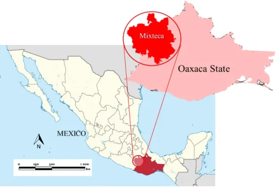
The research site for the investigation is located in Mixteca Region, which is one of the poorest regions in Mexico with land degradation and water scarcity situation. The Ministry of Environment and Natural Resources estimated around 500,000 hectares in the region presented high levels of land degradation in 1998. Mixteca Region is located in Oaxaca State in the southern part of Mexico with a surface of 15,600 km2 and around
450, 000 habitants.
The weather in Mixteca Region according to Koppen and Geiger is classified as Csb, which is for those areas with cool, dry summer and frost danger in winter. According to the National Meteorological Service, the average annual precipitation is of 1988.3 mm and the annual mean temperature is 15.0 ºC.
The objective of this chapter is to assess the local farming situation of the research site. For this reason, El Jicaral Village, Coicoyan de las Flores municipality, Mixteca Region, Oaxaca state, which is the second poorest municipality in Mexico with high levels of soil degradation, was selected for this study. Main crops are rain-fed corn, chili and beans. Due to the uneven topography of the region, the upland fields being mostly situated in hillsides are prone to land degradation process. In this village, questionnaire survey was carried out to local farmers.
3. Land degradation assessment in research site
Soil erosion represents the most extensive areas of degraded land worldwide, as more than 83% of the areas have been affected. In the classification of the land degradation, the processes of soil erosion dominated for rating the degree and extent of
the land degradation. Placed on this statement, land degradation assessment was conducted in El Jicaral Village based on the analysis of several variables observed on topographical maps and satellite images. The results of this assessment showed that more than 35% of the study area was under severe land degradation. To confirm the reliability and accuracy of the remote assessment, land degradation assessment was conducted by means of the field assessment. Accordingly, the objectives of this chapter are to evaluate the viability of the land degradation assessment based on the remote assessment compared with the field assessment and to analyze the level of soil degradation in El Jicaral, Mixteca Region, Mexico.
Both remote and field assessments were done in the study area, on a mesh of 50 meters by 50 meters, covering an area of around 0.5 km2. The results of land
degradation assessment through the field assessment were compared with that through the remote assessment.
In the field assessment, a global navigation satellite system (GNSS) was employed for clarifying the location in every cell. Then observation was conducted based on 'Morgan Coding System' with rating a value from 0 to 5 at the assigned cell. After obtaining a value based on 'Morgan Coding System' for each mesh, a comparison was done between the field assessment and the remote assessment. For the comparison, statistical method using a correlation analysis was employed.
The results of statistical analysis indicated that there was a correlation between both assessments at 99% significant level. It means that the remote assessment based on several variables, such as steepness, slope, vegetation density and land use may be enough for assessing the land degradation in a small scale. This technique is useful when the land degradation assessment is necessary in small areas and it is not possible to conduct an on-site assessment.
According to the remote assessment as well as the field assessment through the survey in the research area, it may be concluded that El Jicaral Village is facing a serious land degradation process due to land use conditions in the village, such as crop cultivation under steep slope conditions, deforestation and cattle overgrazing. Furthermore, no soil conservation practices are conducted and chemical products are being used without understanding of their negative impacts. Due to these conditions, land degradation is a continuing process in El Jicaral Village.
4. Developing soil conservation strategy for Mixteca Region
The application of animal waste is beneficial for soil conservation, especially in lands degraded or being susceptible to erosion. Oaxaca State where Mixteca Region is located, is the main state by number of goats (around 952,000 goats) in Mexico, which represents 10.9% of the national production. In this study, animal waste was used as a natural resource for protecting soils against erosion. The objective of this chapter is to develop a soil conservation strategy with animal waste slurry for mitigating soil loss in leptosol from Mixteca Region.
For this purpose, a raindrop model and a slope model were used. Raindrop model consisted in stainless steel cores of 1.0 cm long with inside diameter at 1.1 cm. Soil was placed inside at a dry density of 1.0 ± 0.1 g/cm3. Fifty drops of artificial rain were
dripped on the soil inside the core and soil loss was measured. On the other hand, slope model consisted of a plot of 91 cm x 3.15 cm x 1.4 cm, with a triangular cross section. Soil was filled in with the same dry density of raindrop model and 1.2 cm3/s of
deionized water was supplied during one hour on a 12 degree slope. Discharge was collected every ten minutes and soil loss was measured.
As a treatment for both models, horse waste slurry was used. It was collected in the Horsemanship Club of Tokyo University of Agriculture and passed through a sieve
at 212 µm in order to obtain slurry. Two treatments were set up; animal waste slurry incorporated with soil, and crust formed with animal waste slurry. The oven dried mass ratio of soil to slurry was 66:1. Soil losses were compared among these 2 treatments. The results of raindrop experiment showed that the addition of animal waste slurry decreased significantly soil loss rate from 6.4% to 1.3% for slurry incorporated cores and to 0.2% for formed bio-crust cores. The same tendency was observed in the slope model experiment, where the application of animal waste slurry reduced significantly the soil losses from 558.6 g/m2 to around 60 g/m2 for both plots where slurry was added.
Concerning the loss of nitrogen component, the results showed that there was a higher release of nitrogen in the control plot than in the other plots where animal waste slurry was applied.
Therefore, it was concluded that the application of animal waste slurry was effective to reduce significantly soil losses by protecting the soil against kinetic energy of raindrops, and it might be effective as well against shearing forces of surface runoff on at 12 degree slope in leptosol soil of Mixteca Region.
5. Treatment of animal waste for elimination of E coli
Although the application of animal waste slurry was effective for mitigating splash and sheet erosion, there is a risk of pollution for efflux of E. coli when applying animal waste slurry. For this reason, treatment for killing E. coli of animal waste was carried out. Air drying was conducted for animal waste slurry. After four weeks, the amount of E. coli, coliform bacteria and general bacteria was measured. On the fourth week, water content of slurry was 695%. There was neither E. coli survival, nor coliform bacteria in the slurry after four weeks of air drying. But the amounts of general bacteria 7 x 10⁴
cfu/g survived. The experiment was done in summer, the maximum temperature was 36 ºC during the experiment. However, usually harvest in El Jicaral Village is done around
September, where the average temperature is around 16 ºC. For this reason, it is recommended to apply an increasing pH treatment, with the purpose of increasing pH to 9.0 and on doing so to kill E. coli and coliform bacteria. In Mexico, and particularly in local indigenous areas, where corn is the main product, there is a process called Nixtamalization that is boiling the corn in an alkaline solution, usually limewater. So, it is recommended to use the residues of this process in the preparation of slurry.
6. Conclusions
This study dealt with land degradation assessment and soil conservation strategy that are applicable in Mixteca Region, Mexico. According to the land degradation assessment, it was confirmed that degradation is advancing in most of research site, with a hilly topography, shallow vegetation cover and main land use as an upland farming. So, it is necessary to conduct soil conservation practices to ensure the future productivity of the farmlands. For this purpose, the application of animal waste slurry was proposed as a soil conservation strategy in the research site, especially for mitigating the occurrence of soil erosion with kinetic energy of raindrops and shearing force of surface runoff. The results showed that the application of animal waste slurry reduced soil loss from 6.4% in control cores to 1.3% in slurry incorporated and to 0.2% in bio-crust formed. The same tendency was observed in the slope model experiments, where the application of animal waste slurry reduced significantly soil losses from 558.6 g/m2 to around 60 g/m2 in both plots where slurry was added.
However, it was considered that there is a potential risk of pollution of water bodies due to the efflux of E. coli when applying animal waste slurry. So, air drying of slurry was conducted as a treatment to kill E. coli. It was found out that this treatment was effective with 0% of E. coli and coliform bacteria survival in the study case. For these reasons, it can be concluded that the air dried slurry application is an effective soil
conservation strategy for mitigating land degradation in El Jicaral Village, Mixteca Region, Mexico.
和文要約
第 1 章 第五研究の背景と目的 土壌は、農業を営む上で不可欠な土地資源である。地球温暖化に伴って高強度 の降雨や干害の発生頻度が高まっている。加えて、化学肥料や農薬に依存した営 農形態は土地資源、特に土壌環境を脅かしている。土地劣化を扱ったレポートや 研究は多数あるものの、土壌環境の劣化は未だに止まっていない。メキシコ国の エルヒカラル村も土地劣化の進行している地域の一つである。 土壌劣化のプロセスは、物理的、生物的、化学的プロセスの三つに大別される。 土壌劣化に影響を与える主因子には、土壌、気候、地形、植生が挙げられ、土壌 については母材や物理的、化学的、生物的な土壌特性が挙げられ、気候について は降水、温度、蒸発散、そして季節の有無が影響している。また地形には傾斜、 水文環境、景観構成要素があり、植生に関して言えば、バイオマス、生物多様性 と生物遷移が挙げられる。 土壌劣化を生じさせるのに、いくつかの原因がある。生物物理学的な原因とし ては土地利用、森林伐採、営農体系、土壌や作物の管理法が関係している。社会 経済的な原因もまた土壌劣化に影響を及ぼしている。例えば、土地保有権、制度 上の課題、市場、貧困、そして健康である。最後は政治的な原因であり、これに は政情安定と政策が挙げられる。土壌劣化は、負のスパイラルの一つで、土壌劣 化が進行すると、自給自足しか行えなくなり、貧困をもたらし、健康被害や栄養 失調等の問題を引き起こす。それによって政治的不安定とともに、自然資源の枯 渇化が進行してしまう危険がある。第 2 章 研究対象地における自然および農業の現状 研究対象地はメキシコ国の中でも最貧困地域で土地劣化と水資源が枯渇して いるミクステカ地域である。1998 年のメキシコ国環境自然資源省に発表による と、ミクステカ地域の約 500,000 ha が高い土地劣化状態にあると見積もられて いる。このミクステカ地域はメキシコ南部のオハカ州に位置し、面積はおける 15, 600 km2 で人口は 450, 000 人である。 コッペンとガイガーによると、ミシュテカ地域の気候は Csb に分類され、夏 は乾燥して涼しく、冬は高湿で寒冷を呈する。国立気象サービスによると、年平 均降水量は 1988.3 mm で年平均気温は 15.0 ℃である。 この章では研究対象地における営農状況に関する調査を扱った。研究対象地 には深刻な土壌劣化が発生しているとともに、メキシコで二番目に貧しい村で あるエルヒカラル村が選定された。主な穀物は、天水とうもろこし、唐辛子や豆 類である。複雑な地形のために、土地劣化の進行しやすい山腹斜面にまでも畑地 が広がっている。そのエルヒカラル村において、現地農家を対象にアンケート調 査を実施した。 第 3 章 研究対象地における土地劣化の評価 世界規模でみて土壌侵食は土地劣化の進行しているほとんどの地域で見られ、 約 83%以上で発生していると推定されている。土地劣化の分類によると、土地 劣化の主な要因は土壌侵食であると報告されている。これに基づき、エルヒカラ ル村における土地劣化の評価を行った。この評価にあたっては、地形図やサテラ イトイメージから取得できるいくつかの変数の分析に基づいた。分析の結果と して、研究対象地の約 35%以上の地域が深刻な土地劣化であることが明らかと
なった。このリモート評価の正確性と信頼性を調べるために、現地調査によるフ ィールド評価を実施した。このように、この章では現地調査と比較したリモート 評価に基づいた土壌劣化評価の適応性の評価を扱った。 研究対象地の約 0.5 km2を対象に 50 m×50 m のメッシュを作成して、リモート 評価と現地調査によるフィールド評価を進め、各々の結果を比較した。現地調査 において各セルの位置の確認には GPS を使用した。現地調査では Morgan Coding System に基づいて、各セルにおける土地劣化の程度を 0 から 5 までの範囲内で 評価し、リモート評価の結果と比較した。 リモート評価と現地調査によるフィールド評価を比較した統計分析の結果、 両方の評価間に 99%のレベルで相関関係があることが明らかとなった。そのこ とは、起伏、傾斜、植生密度や土地利用に基づいたリモート評価によって、土地 劣化の評価を行えることを意味している。現場でのフィールド評価を実行でき ない場合でも、適用できる土地劣化の評価方法として位置づけられる。 またこれらのリモート評価と現地調査によるフィールド評価の結果から、急 傾斜地での営農や森林伐採等が行われているエルヒカラル村では、深刻な土地 劣化の状況にあると判断できた。さらに、エルヒカラル村では土壌保全対策は実 施されておらず、化学肥料や農薬の施用方法も理解しないまま適用されている 現状から、土地劣化は今後も進行するものと考えられた。 第 4 章 ミクステカ地域に適用できる土壌保全対策 有機資源である動物の排出物の適用は土壌保全に有効で、特に劣化した土地 や侵食を受けやすい土壌においては顕著である。メキシコ国オハカ州ではヤギ の飼育が盛んであり、その頭数は約 952,000 頭で国内生産の 10.9%を占めている。
この研究では、動物排出物を土壌侵食防止のための自然資源資材として適用し たものである。具体的にはミクステカ地域のラプトソル土壌からの侵食流出を 軽減するために、動物排出物スラリーを土壌保全対策として適用した。 実験には雨滴モデルと斜面モデルが使用された。雨滴モデルでは、直径 1.1 cm、 長さ 1.0 cm のステンレスコアが使用され、コア中に乾燥密度 1.0±0.1 g/cm3 で土 壌を充填した。このコアに詰まった土壌に人工降雨 50 滴を落下させて、土壌飛 散量を測定した。他方、斜面モデルでは、長さ 91 cm×幅 3.15 cm×深さ 1.4 cm の 三角断面を有している斜面モデルを傾斜 12°に設置して供試した。斜面モデルに 充填した土壌についても雨滴モデルと同じ乾燥密度に調整した。この斜面モデ ルに脱イオン水を供給して、流量 1.2 cm3/s の表面流を 1 時間発生させて 10 分 毎に土壌流亡量を測定した。 両モデルにおいて動物排出物のスラリーを適用した。馬糞は東京農業大学農 友会馬術部より採取し、212 µm のふるいを通過させてスラリーを作成した。こ のスラリーの土壌への適用には 2 つ方法が採られ、一つは動物排出物スラリー を土壌に混合する方法で、もう一つは動物排出物スラリーを土壌表面に散布し てクラストを形成する方法である。土壌に対するスラリーの炉乾燥質量比は 66 : 1 とした。雨滴モデルによる実験の結果、スラリー混合およびスラリーでクラス ト形成した場合、土壌飛散量は無処理の 6.4%から 1.3%および 0.2%にまで減少 することが明らかとなった。斜面モデル実験でも同じ傾向を観察でき、スラリー 混合およびスラリーでクラスト形成した場合、558.6 g/m2を記録した無処理の土 壌流亡量が、両モデルともおよそ 60 g/m2にまで減少する結果となった。窒素成 分に関しても、スラリー混合およびスラリーでクラスト形成した場合、有意で無
処理を下回る結果となった。 従って、動物排出物スラリーの土壌保全対策としての適用は、雨滴による運動 エネルギーに対しても、傾斜 12°で発生した表面流によるせん断力に対しても、 ミクステカ地域で採取されたラプトソル土壌の侵食量を軽減するために有効で あると考察された。 第 5 章 動物排出物からの大腸菌の処理 動物排出物スラリーの土壌保全対策としての適用は、雨滴侵食に対しても、面 状侵食に対しても有効であったが、動物排出物スラリーの適用によって E. coli 汚染が拡散する恐れがある。そこで、動物排出物スラリー中の E. coli 殺菌の処 置について研究を進めた。ここでは乾燥処理について扱った。スラリーの作成か ら 4 週間乾燥処理を進めたところ、スラリーの含水比は 695%にまで低減した。 併せて、E. coli と大腸菌群、一般細菌を測定した結果、E. coli および大腸菌群は 検出されず、一方、一般細菌は 7×10⁶ cfu/g であった。 実験は夏期に実施しており、最高温度は 36 ℃を記録した。しかし、通常エル ヒカラル村の収穫期は 9 月頃であり、その月の平均温度はおよそ 15.6 ℃である。 その温度では動物排出物スラリー中の E. coli の殺菌は期待できず、エルヒカラ ル村では pH 9.0 まで上昇させる pH 処置が適正であると考察できた。エルヒカ ラル村では石灰水などのアルカリ性溶液でコーンを茹でる食品加工プロセスが あり、動物排出物スラリー中の E. coli の殺菌にはこの石灰水の残液が使用でき ると判断した。 第 6 章 結論 この研究は、メキシコ国ミクステカ地方における土地劣化の評価と現地で適
用できる土壌保全対策を扱ったものである。土壌劣化の評価では、大部分の研究 対象地において傾斜地形、低い植生密度、畑作の実施などにより土地劣化が進行 していることを確認できた。農地における将来の生産性を確保するためにも、土 壌保全対策を実施することが必要であると判断した。 そこで研究対象地における土壌保全対策として、動物排出物スラリーの適用 を提案した。雨滴モデルによる実験の結果、スラリー混合およびスラリーでクラ スト形成した場合、土壌飛散量は無処理の 6.4%から 1.3%および 0.2%にまで減 少することが明らかとなった。斜面モデル実験でも同じ傾向を観察でき、スラリ ー混合およびスラリーでクラスト形成した場合、558.6 g/m2を記録した無処理の 土壌流亡量が、両モデルともおよそ 60 g/m2にまで減少することが明らかとなっ た。 しかし、動物排出物スラリーの適用によって E. coli 汚染が拡散する恐れがあ る。そこで、動物排出物スラリー中の E. coli 殺菌の処置について研究を行った。 ここでは乾燥処理を進めたところ、E. coli と大腸菌群は検出されない結果となっ た。これらの結果から、メキシコ国ミクステカ地方エルヒカラル村の土地劣化の 軽減を目指した風乾処理済みの動物排出物スラリーの適用は有効な土壌保全対 策であると判断できた。
Acknowledgement
Firstly, I would like to express my gratitude to MEXT for the financial support to continue my education in this wonderful country.
I would like to thank my advisor Professor Dr. Machito Mihara, for his continuous support all these years on my graduate school studies at Tokyo University of Agriculture, for his patience, motivation, and knowledge. His guidance helped me all the time during writing of this thesis. I would also like to express my gratitude to the rest of my thesis committee: Prof. Dr. Fumio Watanabe, Prof. Dr. Sawahiko Shimada and Assistant Prof. Dr. Hiromu Okazawa, for their valuable comments and questions which incented me to widen my research from several perspectives.
My sincere thanks also goes to all my colleagues in the Laboratory of Land and Water Use Engineering, for their kind support through the seminars and academic activities in this laboratory, as well as through the experiments that constitute this thesis. To the farmers of El Jicaral Village for their support throughout this investigation, my deepest thanks to them, as well as all the persons involve in this research.
My heartfelt gratitude to my wife and son, for their love and unconditional support, we made it! To my twin brother for his invaluable help, to my mother and all our family in Mexico and Russia, thank you for all your love, care and assistance during these years.
Table of contents
Summary 和文要約 (Summary in Japanese) Acknowledgement Table of Contents List of Figures List of TablesChapter 1 Background and objectives 1.1 Background
1.1.1 Overview of Mexico 1.1.2 Population in Mexico
1.1.3 Socioeconomic situation in Mexico 1.1.4 Environment
1.1.5 Soil degradation
1.1.6 Soil degradation categories
1.1.7 Soil degradation by type and area in the world 1.1.8 Soil degradation in Mexico
1.1.9 Soil conservation strategies 1.2 Objectives
1.2.1 Overall objectives of this dissertation 1.2.2 Objectives of each chapter
References of this chapter
Chapter 2 Natural and agricultural conditions in research site 2.1 Introduction of this chapter
2.1.1 Background 2.1.2 Objectives
2.2 Description of study site 2.2.1 Mixteca Region
2.2.2 Climate, precipitation and topography 2.2.3 Land degradation in Mixteca Region 2.3 Local farming survey in the study site
2.3.1 Study site
2.3.2 Rainfall measurement 2.3.3 Questionnaire survey 2.4 Results and discussion
i viii xiv xv xviii xx 1 2 2 3 4 5 5 7 8 9 11 12 12 12 15 17 18 18 19 19 19 20 21 24 24 25 27 30
Table of contents (continuation)
2.5 Conclusions of this chapter References of this chapter
Chapter 3 Land degradation assessment in research site 3.1 Introduction of this chapter
3.1.1 Background 3.1.2 Objective 3.2 Research methods
3.2.1 Research site
3.2.2 Land degradation assessment 3.2.3 Direct assessment
3.2.4 Indirect assessment 3.3 Results and discussion
3.3.1 Direct assessment results 3.3.2 Indirect assessment results 3.4 Conclusions of this chapter References of this chapter
Chapter 4 Developing soil conservation strategy for Mixteca Region 4.1 Introduction of this chapter
4.1.1 Background 4.1.2 Objectives 4.2 Research methods
4.2.1 Soil samples
4.2.2 Splash erosion experiment 4.2.3 Surface runoff experiment 4.3 Results and discussion
4.3.1 Splash erosion experiment 4.3.2 Surface runoff experiment 4.4 Conclusions of this chapter References of this chapter
33 34 36 37 37 37 37 37 38 39 42 44 44 50 55 56 57 58 58 59 59 59 61 64 66 66 68 72 73
Table of contents (continuation)
Chapter 5 Treatment of slurry for elimination of E.coli 5.1 Introduction of this chapter
5.1.1 Background 5.1.2 Objectives 5.2 Research methods
5.2.1 Samples
5.2.2 Total phosphorus and total nitrogen 5.2.3 Measurement of microorganisms 5.2.4 Air drying method
5.3 Results and discussion
5.3.1 Total nitrogen and phosphorus in animal waste samples 5.3.2 Counting microorganisms in animal waste samples 5.3.3 Air drying process
5.5 Conclusions of this chapter References of this chapter Chapter 6 Conclusions Appendix 74 75 75 76 76 76 76 76 78 78 78 80 81 83 84 85 89
Fig. 1-1 Fig. 1-2 Fig. 1-3 Fig. 1-4 Fig. 1-5 Fig. 1-6 Fig. 1-7 Fig. 1-8 Fig. 1-9 Fig. 2-1 Fig. 2-2 Fig. 2-3 Fig. 2-4 Fig. 2-5 Fig. 2-6 Fig. 2-7 Fig. 2-8 Fig. 2-9 Fig. 2-10 Fig. 2-11 Fig. 2-12 Fig. 2-13 Fig. 2-14 Fig. 3-1 Fig. 3-2 Fig. 3-3 Fig. 3-4 Fig. 3-5 Fig. 3-6 Fig. 3-7 Fig. 3-8 Fig. 3-9 Fig. 3-10
List of Figures
Map of MexicoPopulation and growth rate in Mexico, 1900 - 2050 Human development index (HDI) by state, 2004
Ecological footprint and biocapacity in Mexico, 1961-2005 Soil degradation
Soil degradation in the world (Million hectares) Soil degradation in Mexico
Soil erosion in Mexico
Research structure of this dissertation Mixteca Region, Mexico
Climatological normal values for Mixteca Region, 1951-2010 Land degradation in Oaxaca State
Disaster levels of soil degradation Soid erosion units
Types of erosion in Mixtec Region El Jicaral Village, Mixteca Region Rain Gauge installed in El Jicaral Village Monthly rainfall in 2014 in El Jicaral Village Rainfall intensity in El Jicaral Village
Questionnaire survey application Basic information of local farmers Application of agricultural chemicals Current problems in farming systems Land degradation in El Jicaral
Mesh projected in El Jicaral community Projected mesh in the research site Steepness and slope
Vegetation density values Land use values
Steepness values Slope values
Vegetation density values Land use values
2 3 4 5 6 9 10 11 13 19 20 21 22 23 24 25 25 26 27 28 30 31 31 38 39 40 41 41 42 44 45 46 47
Fig. 3-11 Fig. 3-12 Fig. 3-13 Fig. 3-14 Fig. 3-15 Fig. 3-16 Fig. 4-1 Fig. 4-2 Fig. 4-3 Fig. 4-4 Fig. 4-5 Fig. 4-6 Fig. 4-7 Fig. 4-8 Fig. 4-9 Fig. 4-10 Fig. 4-11 Fig. 4-12 Fig. 4-13 Fig. 4-14 Fig. 4-15 Fig. 4-16 Fig. 5-1 Fig. 5-2 Fig. 5-3 Fig. 5-4 Fig. 5-5 Fig. 5-6
List of Figures (continuation)
Land degradation calculationLand degradation by remote assessment Land degradation assessment in the field Land degradation by field assessment
Comparison between land degradation assessment (remote and field methods)
Correlation between land degradation assessment by simple regression analysis
Goat overgrazing in Mixteca Region Soil samples from Mixteca Region Animal waste slurry
Stainless cores for raindrop experiment
Raindrop velocity for calculating kinetic energy Treatments for splash erosion experiment Splash erosion model
Surface runoff plot model
Treatments for surface runoff experiment Raindrop impact in soil samples
Raindrop experiment results Soil loss rate between treatments Runoff experiment plots
Surface discharge
Cumulative amount of soil losses Total nitrogen losses
Dilution of sample for counting microorganisms Dilution method for counting microorganisms Total nitrogen and total phosphorus analyses Counting of E.coli and conliform bacteria Counting of general bacteria
Air drying process
48 49 50 51 52 52 58 59 61 62 62 63 64 65 66 66 67 68 69 69 70 71 77 77 78 80 80 81
Table 2-1 Table 2-2 Table 2-3 Table 2-4 Table 3-1 Table 3-2 Table 4-1 Table 4-2 Table 5-1 Table 5-2 Table 5-3 Table 5-4
List of Tables
Soil degradation in Oaxaca stateRainfall data in El Jicaral Village (2014)
Questionnaire survey for land degradation assessment Contents of the questionnaire survey
Coding system for soil erosion appraisal in the field
Correlation between three variables observed (slope, vegetation and land use) and remote assessment results
Physical and chemical properties of soil Properties of soil and animal waste
Amount of total nitrogen and total phosphorus for goat dung samples
Amount of total nitrogen and total phosphorus for several animal waste
Microorganisms present in animal waste samples Air drying process
22 26 27 29 43 54 60 60 79 79 81 82
Chapter 1
1.1 Background
1.1.1 Overview of Mexico
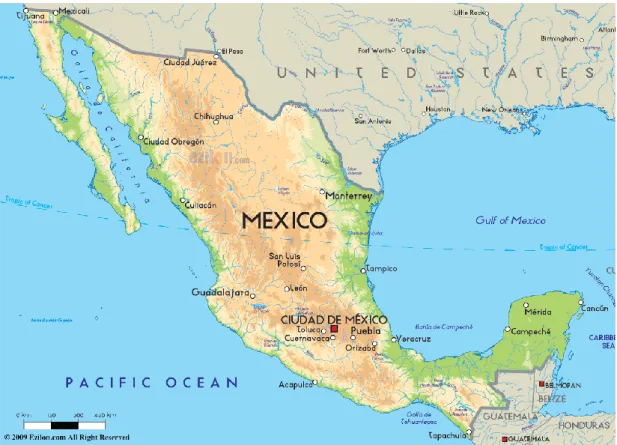
Mexico is a federal republic located in the north of America continent (Fig. 1-1). It shares the north border with the United States, the southeast border with Guatemala and Belize. On the west and south is faces the Pacific Ocean, and on the east the Gulf of Mexico. The total area is almost 2 million square kilometers (1,920,550 km2), and 2.5% of its territory is covered by water. It is located between
latitudes 14º and 33ºN and longitudes 86º and 119ºW. Mexico is crossed by two mountain ranges, from north to south, called Sierra Madre Oriental and Sierra Madre Occidental. For this reason, most of Mexico’s area is located in high altitudes.
1.1.2 Population in Mexico
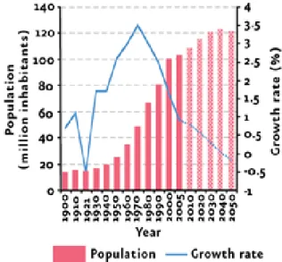
The population is estimated of being over 120 million (INEGI, 2010), placing the country as the eleventh most populous in the world, and the first by number of native Spanish speakers (Fig 1-2).
According to Conapo, 2006, the increasing in population will continue until 2042, where for the first time since 1921 the population will start to decrease. There are several factors, including the reduction in fecundity. In 1970 a woman had in average 6.7 children, and in 2005 this decreased to 2.2. Other factors include increase of mortality rate, from 5.0% in 2005 to 6.8% in 2050.
Fig. 1-2 Population and growth rate in Mexico, 1900 – 2050
(Conapo, 2005)
With the increase in the population, urbanization is a current phenomenon in Mexico. When people move to the cities, there is a high pressure in local ecosystems. On 1900, around 75% of the population lived in rural areas throughout the country, but in 2005, only 23.5% lived in those areas (Anzaldo-Gomez, C., 2006). The excessive concentration of people in urban zones usually has negative consequences
Rural areas are often the most vulnerable, where subsistence agriculture is conducted and where basic services, such as health care, education, clean water, energy supply are not available.
1.1.3 Socioeconomic situation in Mexico
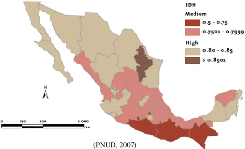
Socioeconomic situation in a country can be known through the level of poverty of its population. For measuring the poverty, several indicators have been established. One of these indicators is the Human Development Index (HDI), formulated by the United Nations Development Program (UNDP, 2006) to classify countries based on three parameters, namely: health, education and income. The results are shown through a coefficient between 0 and 1. According to the report of UNDP 2006, the human development index for Mexico was calculated at 0.8031. This value is slightly above the HDI level that separates the countries with a high human development (Fig 1-3).
Fig. 1-3 Human development index (HDI) by state, 2004
Nevertheless, at municipality level inside Mexico it can be found that the Human Development Index is very low. For example, in Coicoyan de las Flores, Mixteca Region, this value is about 0.4768. Coicoyan is a rural municipality, with an
indigenous population of around 98%. The main economic activity in this municipality is subsistence agriculture.
1.1.4 Environment
There are several ways to measure the impact of population on the environment. One of the most representative is the ecological footprint, which refers to the total area of the earth used by an individual, country or the entire world for providing the resources that will satisfy the demand of the population (WWF, 2008). In Mexico, a study was conducted using the footprint indicator to calculate the current environment situation (Semarnat, 2006).
Fig. 1-4 Ecological footprint and biocapacity in Mexico, 1961-2005
As can be observed in the above figure (Fig. 1-4), Mexico, as several countries in the world has overpassed the biocapacity level, which means that the current development is not sustainable and that the negative impact for the environment is bigger and bigger.
1.1.5 Soil degradation
quality to provide support for humans (Lal, 2001). This could be understood as the weakening of soil productivity, its capacity to moderate environment and the reduction of biodiversity (Fig. 1-5).
Fig. 1-5 Soil degradation
The soil degradation problem has been affecting the earth surface since the very start of agriculture (Lowdermilk, 1953). Problems related with degradation of soil, such as erosion, overgrazing and deforestation have made empires fall apart and big civilizations to disappear. Nowadays, due to the fast increase in population, pressure on natural resources is higher, accentuating soil degradation risks drastically (Richards, 1991).
For these reasons, it is important to understand soil degradation, causes that produce it and factors that are involved in this process.
Soil degradation processes are divided into three types: physical, chemical and biological (Lal, 1998). Physical degradation can be observed as erosion, compaction, crusting and structural decline in general. Chemical degradation can be described as acidification, salinization, leaching, nutrient imbalance, volatilization and decrease in
CEC. Biological degradation can be summarized as the reduction in soil biodiversity and the decrease of soil organic carbon.
Factors that influence soil degradation processes are soil properties, climate, topography and vegetation.
Among soil properties are the parental material and all those inherent properties of the soil, such as horizons, physical, chemical and biological properties. Concerning the climate, factors that influence soil degradation are precipitation, temperature, evapotranspiration and seasons. Topographic factors include slope, drainage density and landscape position. Vegetation factor has to do with biomass, biodiversity and succession.
There are several causes that produce soil degradation. Bio-physical causes are those related with land use, deforestation, cropping systems, soil and crop management (tillage and drainage). Also, socio-economic causes influence in soil degradation, such as tenure of the land, institutional strength, markets, poverty and health. Last but not least, the political causes, namely, political stability and policies. Soil degradation is part of a descending spiral, where degraded soils are only capable to carry out subsistence agriculture, leading to poverty, which leads to poor health and malnutrition, conducting to political instability, putting more pressure in resources such as soil, and so on.
1.1.6 Soil degradation categories
According to Oldeman, 1998, soil degradation can be divided in two categories, based on the agents that produce it. The first category is about external agents that produce soil degradation by displacement of soil material, namely water erosion and wind erosion. Water erosion can be observed on site as loss of topsoil and terrain
destruction of sea beds (Oldeman, 1988). Regarding the effect of wind erosion, it can be observed on site as loss of topsoil and terrain deformation, and off-site as overblowing, affecting roads, buildings and vegetation cover.
The second category is by internal soil deterioration, including those processes that affect soil properties and structure. These processes are physical deterioration, chemical deterioration and biological deterioration. Physical deterioration involves sealing and crusting of topsoil, compaction, deterioration of soil structure, waterlogging, acidification and subsidence of organic soils. Chemical deterioration includes loss of nutrients, pollution and acidification, salinization, discontinuation of flood induced fertility, among other chemical problems. Biological deterioration is the loss of balance of microbiological activity in the top soil (Oldeman, 1988).
1.1.7 Soil degradation by type and area in the world
Soil degradation was classified by FAO 1995. According to this classification, Asia presented the wider area affected by soil degradation, with 747 million hectares, followed by Africa, 494 million hectares and South America, 243 million hectares. As can be observed, water erosion accounted for the main factor causing soil degradation (Fig. 1-6).
Fig. 1-6 Soil degradation in the world (Million hectares)
1.1.8 Soil degradation in Mexico
In Mexico several studies about soil degradation have been conducted. The most recent being the assessment of soil degradation caused by man in Mexico (Semarnat-CP, 2003), with a scale of 1:250,000.
For this study, four degradation processes were considered: water erosion, wind erosion, chemical degradation and physical degradation. As can be observed in Fig. 1-7, more than 50% of the soils did not present evidence of degradation. However, chemical degradation accounted for the main process of soil degradation, affecting almost 18% of the country’s surface area. Water erosion was the next process with
11.9%, wind erosion with 9.5% and physical degradation with 5.7%
Fig. 1-7 Soil degradation in Mexico
Through this assessment it was calculated the soil erosion by level in Mexico (Fig. 1-8). The most affected areas were the mountainous regions of Sierra Madre, as well as wide areas in several states in the south (Chiapas, Guerrero and Oaxaca).
Fig. 1-8 Soil erosion in Mexico
1.1.9 Soil conservation strategies
The main purpose of soil conservation strategies is to get the highest level of sustained production from a certain cultivated area and at the same time to maintain soil loss under a level where soil can recover naturally (Morgan, 1996).
For achieving this, soil must be protected from the detachment and transport of soil particles due to the effect of rain drops splash. It is also effective to improve the soil properties to increase the infiltration and reduce runoff.
According to Morgan, 1996, conservation strategies can be divided in three big categories: agronomic measures, soil management and mechanical methods. Agronomic measures rely on the coverage by vegetation to protect the soil. Soil management consist in the preparation of soil to increase its resistance to erosion improving its structure. The last one, mechanical methods, involve engineering structures to change the relief. Often this last practice is very expensive, and can be avoided if good soil management is carried out.
(Semarnat-CP. 2003)
Very slight (less than 5) Slight (5-10) Moderate (10-50) High (50-200)
Very high (more than 200)
1.2 Objectives
1.2.1 Overall objectives of this dissertation
For the present dissertation entitled ‘Soil Degradation Assessment and Soil Conservation Strategy for Mixteca Region, Mexico’ the overall objective is to discuss the most convenient, effective and adaptable erosion control system for the research site. In achieving the goal of this dissertation, objectives were implemented as follows:
(1) To evaluate soil degradation condition in the research site
(2) To analyze the effectiveness of a proposed soil conservation strategy (3) To evaluate the application of the proposed conservation strategy 1.2.2 Objectives of each chapter
In order to achieve the overall objectives and for giving a general overview of this dissertation, the research structure was formulated as shown in Fig. 1-9. In the present chapter it was stated that soil degradation is a serious environmental problem that affects deeply the capacity of human beings’ surviving, and that it is present in every continent. In Mexico it is also a problem that needs to be addressed to the immediate future. One of the main reasons of soil degradation is the level of poverty that is present in several municipalities inside the country.
For this reason, the land degradation process was calculated in a study case in El Jicaral Village, and then the use of local resources was tested in order to propose a conservation strategy easy to adopt and replicate in several regions of the country.
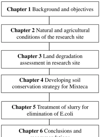
Fig. 1-9 Research structure of this dissertation
Regarding to this, Chapter 2 deals with the definition of the research site, which is located in Mixteca Region, classified as one of the poorest areas in Mexico, with almost one third of its territory under the effects of high levels of land degradation. The objective of this chapter is to assess the local farming situation by means of a questionnaire survey.
Chapter 3 focuses on land degradation, taking soil erosion processes as
indicators of its extent and severity. Land degradation assessment was conducted in El Jicaral Village, Mixteca Region, based on the analysis of several variables observed on topographical maps and satellite images (remote assessment). To confirm its reliability, land degradation assessment was conducted by means of a field assessment. Therefore the objectives of this chapter are to analyse the level of
Chapter 1 Background and objectives
Chapter 2 Natural and agricultural conditions of the research site
Chapter 3 Land degradation assessment in research site
Chapter 4 Developing soil conservation strategy for Mixteca
Region
Chapter 5 Treatment of slurry for elimination of E.coli
Chapter 6 Conclusions and recommendations
assessment based on the remote method compare to the field method.
The results showed that there was correlation between both assessment methods at a significant level of 99%. For this reason, this technique might be useful when land degradation assessment is necessary in small areas and it is not possible to conduct an on-site assessment.
Since more than one third of the area was identified as under land degradation, it is necessary to develop a conservation strategy which could help to mitigate this tendency. In order to do this, in Chapter 4 it is discussed the convenience of using animal waste as a conservation strategy, since the application of animal waste is beneficial to soil, especially in land degraded areas. For this study, it was used animal waste, since it is an available resource in the study site. The objective of this study is to develop a soil conservation strategy using animal waste slurry in order to mitigate soil loss in Mixteca Region. Results of soil loss experiments showed that there is a significant reduction of soil loss when using animal waste slurry compared to the control plot.
Even though the application of animal waste slurry was effective for mitigating soil loss, in Chapter 5 it is intended to eliminate E.coli inside animal waste, in order to ensure that the addition of animal waste will improve soil conditions without harming the environment. For this reason air drying treatment was conducted. It was found that this treatment reduce significantly the amount of E.coli and coliform bacteria, and did not affect significantly the amount of general bacteria inside the animal waste.
Chapter 6 summarizes the outcome of each chapter of this dissertation and
states the overall conclusion of the present study entitled: “Land Degradation Assessment and Soil Conservation Strategy in Mixteca Region, Mexico”.
References of this chapter
Anzaldo-Gomez, C. and Rivera-Vasquez, A. 2006. Evolución demográfica y potencial de desarrollo de las ciudades de México.
Conapo. 2005 Índices de marginación, México
Conapo. 2006 Proyecciones de la población de México 2005-2050. México Coneval. Mapas de pobreza por ingreso y rezago social 2005. México. 2007. FAO, 1995. Dimensions of need: an atlas of food and agriculture. Italy. INEGI 2010 Census statistics
Lal, R. 1998 Soil erosion impact on agronomic productivity and environment quality. Critical review. Plant Science 17:319-464
Lal, R. 2001 Soil degradation by erosion. Land Degrad. Develop. 12, 519-539. Lowdermilk, W.C. 1953 Conquest of the land through 7000 years. USDA-SCS.
Agricultural Information Bulletin 99. US Department of Agriculture: Washington, DC.
Morgan, R.P.C. 1996. Soil erosion and conservation. Ed. Longman. UK.
Oldeman, L.R. 1988 Guidelines for general assessment of the status of human-induced soil degradation. International Soil Reference and Information Centre. ISRIC.
Oldeman, L.R. 1998 Soil degradation: a threat to food security? International Soil Reference and Information Centre. ISRIC.
PNUD. 2007. Informe sobre desarrollo humano en México 2006-2007.
Richards, J.F. 1991 The earth as transformed by human action. Global and regional changes in the biosphere over the past 300 years. Cambridge University Press: New York; 163-178.
Semarnat, 2006. Impacto humano en el medio ambiente.
Semarnat-CP 2003 Evaluación de la degradación del suelo causada por el hombre en la República Mexicana, escala 1:250,000. Memoria nacional 2001-2002.
National System of Environmental Information and Natural Resources (SNIARN) 2008 Mexico’s State of the Environment Report 2008. Mexico
UNDP, 2006 Informe sobre el desarrollo humano de los pueblos indígenas de México.
Chapter 2
2.1 Introduction of this chapter
2.1.1 Background
One of the main problems when conducting investigation in the traditional way, including that carried out in rural communities in Mexico, as well as in any other part of the world, is that the final outcome, being methodologies or technologies, hardly is applied to resolve the problems they were designed for.
For this reason, emphasis is done in the use of participatory investigation (Velásquez, 2002), which main purpose is that the knowledge obtained through the investigation is available for all the persons involved.
In order to achieve the active participation of the studied communities, is vital the involvement of the researcher in the productive activities of these communities, even though it is a tough work, and uncommon, is the most efficient way to apply the scientific knowledge generated during the research. This approach is essential in the short term in developing countries (Baraza, 2008).
Nevertheless, in order to analyze deeply the bio productive and socioeconomic environment, in addition to the direct interaction with the community, it is necessary to measure quantitatively these aspect by means of a questionnaire survey applied to the family production units (Hérnandez Hernández, 2004).
2.1.2 Objectives
The objective of this chapter is to assess the local farming situation in El Jicaral Village, Mixteca Region.
2.2 Description of study site
2.2.1 Mixteca Region
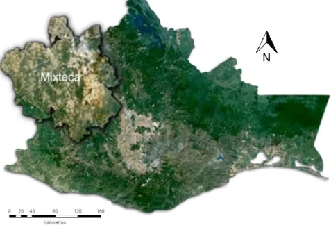
Mixteca Region is located at the convergence of three states: Puebla, Guerrero and Oaxaca, in the southern of Mexico. The Oaxacan Mixteca Region (Fig. 2-1) has surface of 15, 600 km2 (INEGI, 2005) and around 450, 000 habitants (INEGI, 2010). Out of the habitants of these region, 68% live in rural areas and 35% belong to an indigenous groups, which could be Mixtecos (majority), the Triqui, the Chochomixtecos, the Amuzgos, and the Tacuates (SAGAR, 1999).
2.2.2 Climate, precipitation and topography
According to Velásquez (2002), the predominant climates present in Mixteca Region are semitropical (Acw), semitropical temperate (C(w)) and temperate semiarid (Bs1k) . The average annual rainfall for this region ranges from 300 to 750 mm, distributed between June and October (INEGI, 1996).
The climatological values observed in Coicoyan de las Flores, Mixteca Region (latitude: 17°15’00” N, longitude: 098°17’59” W, Elevation: 2003 masl) are shown in Fig. 2-2 . The average annual rainfall is 1988.3 mm and average mean temperature is 15 Celsius degrees (SMN, 2010).
Fig. 2-2 Climatological normal values for Mixteca Region, 1951-2010
About the topography, the terrain is mountainous, and usually the farming practices are conducted on hillsides or at the edge of gullies, mainly for self-consumption. Altitude ranges from 1000 to 3000 masl.
Soils in Mixteca Region are generally lacking organic matter and deficient in nitrogen as well as several important micro nutrients. pH of soil are 6.8 to 8.7, and
0 2 4 6 8 10 12 14 16 18 0 50 100 150 200 250 300 350 400 450
Jan Feb Mar Apr May Jun Jul Aug Sep Oct Nov Dec
T em p er atur e (ºC ) P re cip itat ion (m m ) Month
are often of medium texture. Most farming fields have pronounced slopes of 9 to 20% (SAGAR, 1999).
Local economy in this region is based on agriculture, mainly producing crops such as corn, beans and wheat, and grazing of livestock, such as goats, cows and sheep. Other main source of income is the money sent back by relatives working outside the region, inside Mexico or in the United States.
2.2.3 Land degradation in Mixteca Region
This region is characterized as being one of the poorest regions in Mexico, with high levels of land degradation, deforestation and water shortages. The Ministry of Environment and Natural Resources (Secretaría de Medio Ambiente y Recursos Naturales, SEMARNAT) estimated around 500,000 hectares in the region (Fig. 2-3) presented high levels of land degradation in 1998 (Semarnat-CP, 2003).
Fig. 2-3 Land degradation in Oaxaca State
Based on the study on soil erosion of Mexico conducted by Semarnat-CP (2003), it was calculated the surface of Oaxaca state affected by soil degradation
processes, namely: physical degradation, chemical degradation, water erosion and wind erosion (Oldeman, 1998).
For Oaxaca state, chemical degradation (17.9%) and water erosion were the main processes of soil degradation (Table 2-1).
Table 2-1 Soil degradation in Oaxaca state
Physical degradation
Chemical
degradation Water erosion Wind erosion
4,833 km2 16,786 km2 16,684 km2 438 km2
5.2 % 17.9 % 17.8 % 0.5 %
As a result of historical processes of deforestation, overgrazing and the change of land use to agricultural fields after the Spanish colonization, erosion has reached high levels of disaster (Fig. 2-4), and for this reason Mixteca Region is considered as an ecological disaster area (Martínez and Altieri, 2006).
For the analysis of geographical data obtained from INEGI (2014), the software ArcGIS 10.2 was used. The analysis consists of three variables: type of erosion, form of erosion and degree of affectation.
About the variable of type of erosion, this was classified in four categories: hydric (H), eolic (E), anthropogenic (A), and no evident erosion (SE).For form of erosion, variables are: gully (C), furrow (S), laminar (L), mound (M) dune (D) and other (O).
In case of degree of affectation, variables were: slight (1), moderate (2), strong (3) and extreme (4).
Soil erosion units are compounded of three elements: the first letter is the type of erosion, the second is the form and the third one is the degree (Fig. 2-5).
Fig. 2-5 Soil erosion units
A map was processed using the above mention classification for soil erosion in Mixteca Region, Mexico (Fig.2-6).
According to the values of the map, it could be observed that the bigger area is for not evident soil erosion (SE), with more that 25%. The next one, with more that 12% corresponds to HL1 unit, that means that hydric erosion (H), in the form of laminar runoff (L) in a slight degree is the most significant in the region.
Fig. 2-6 Types of erosion in Mixteca Region
The erosion in Mixteca Region is a consequence of low productivity farming activities that put pressure on the environment, such as deforestation, overgrazing and slash and burn agricultural activities (UNEP, 2010).
2.3 Local farming survey in the study site
2.3.1 Study site
For this research El Jicaral Village, Coicoyán de las Flores Municipality, Mixteca Region was chosen because the degree of poverty is high, also it locates in the most land degraded region of the country (PNUD, 2008). El Jicaral Village is an indigenous community with around 1,000 inhabitants, in which people speak in Mixtec, ancient language in the area. The main crops in the village are corn, chili and
beans. It locates in the coordinates 17º 07’ 34.6” latitude North and 98º 11’ 48.9” longitude West (Fig. 2-7).
Fig. 2-7 El Jicaral Village, Mixteca Region
2.3.2 Rainfall measurement
In order to get a better understanding about the rain patterns in El Jicaral, a data logging rain gauge, model RG3 of Onset Company was installed and data was collected during all the year 2014.
The annual precipitation in El Jicaral Village for 2014 was 2,553.6 mm. The rainy season was comprehend between the months of May to October (Table 2-2) Table 2-2 Rainfall data in El Jicaral Village (2014)
Total Monthly Rainfall (mm) Maximum Daily Rainfall (mm) Highest Rainfall Intensity (mm/hr) Jan 8.4 3.8 2.8 Feb 0 0 0 Mar 0 0 0 Apr 20.4 20.4 19.4 May 375.4 80.8 49.6 Jun 495.0 49.2 25.6 Jul 273.0 71.2 53.6 Aug 428.8 81.0 32.6 Sep 438.0 54.4 38.0 Oct 422.8 175.8 22.0 Nov 72.6 61.2 33.8 Dec 19.2 8.4 5.2
June was the month with the highest amount of rainfall, with 495 mm (Fig. 2-9)
Fig. 2-9 Monthly rainfall in 2014 in El Jicaral Village 495 0 100 200 300 400 500 600
Jan Feb Mar Apr May Jun Jul Aug Sep Oct Nov Dec
R
ainfa
ll
(mm)
Through the collected data, an analysis was carried out to calculate the rainfall intensity (millimeter of rain per hour) in a given day. It was found that the maximum intensity occurred on July 20, with 53.6 mm/hr, followed by and event of May 27, with a rainfall intensity of 49.6 mm/hr (Fig. 2-10).
Fig. 2-10 Rainfall intensity in El Jicaral Village
2.3.3 Questionnaire survey
In order to assess the farming situation in El Jicaral Village, a questionnaire survey was conducted. 24 questions, divided into three sections such as ‘Basic information of local farmers’, ‘Application of agricultural chemicals’ and ‘Current problems in farming systems’ are shown in Table 2-3.
Table 2-3 Questionnaire survey for land degradation assessment
Basic information of local farmers
Application of agricultural chemicals
Current problems in farming system
Name, Age, Gender Application of chemical
fertilizers, formula, quantity
Main problems in the farming system Number of family members
working in agricultural sector
Amount of money expend
for chemical fertilizers Soil erosion awareness
Crops, area cultivated, destination of production
Application of pesticides and herbicides
Attendance to soil conservation workshops Water source, breeding of
animals Application frequency
Concrete information about crops 49.6 53.6 0 10 20 30 40 50 60 1 2 3 4 5 6 7 8 9 10 11 12 Month Ma xim um r ainfa ll int ensit y (mm/ hr) pe r da y
The survey was conducted in July, 2013 in the village with the assistance of a Spanish-Mixtec translator at the workshop on ‘Soil conservation for sustainable agriculture’ (Fig. 2-11). The targets were local farmers, being older than 18 years old, who have been conducting agriculture in the village. From one household, only one representative was invited to attend the workshop. There were 69 household interviewees in the workshop and it counted 35% of all 200 households in the village. Due to their local customs, the survey must be divided into several times for each group with around 10 persons.
Table 2-4 Contents of the questionnaire survey Soil Conservation Questionnaire Survey
(Local Farming Situational Approach – A Preliminary Survey) El Jicaral, Mixteca Region, Mexico
1. Name: ……… 2. Age:………. 3.
□
Male□
Female 4. Address: ……… 5. Total numbers of family member: ……….. person/people6. Number of family members working in agricultural sector: ………….. person/people 7. Total area of agricultural land owned: …………..m2
, cultivated: …………..m2 9. What kind of crops are you cultivating in your field?
Name of crop: …………Maize……. Total: ………. m2
. Month of cultivation: ……… Name of crop: ………Beans…….…. Total: ………. m2
. Month of cultivation: ……… Name of crop: ……Pumpkin………. Total: ………. m2
. Month of cultivation: ……… 10. What did you do on the products?
□
For family consumption□
Put into the market. Amount: .………Pesos/year11. Which sources of water are you using for irrigation? (Check any of the items below)
□
Rain water□
Ground water□
Tap water□
Pond□
River□
Others……….… 12. What problems are there in your farmland? (Check any of the items below)
□
Hard to cultivate□
Low fertility□
Lot of stones□
Slope□
Erosion□
Others……….…… 13. Are you conducting slash-and-burn farming?
□
Yes (Which month? ………)□
No14. Do you breed any animals?
□
Yes (Kind of animals:………...Total numbers…..…… )□
No15. Do you carry on any sustainable farming practice?... 16. Do you know about soil erosion and its effect?
□
Yes□
No (If yes, please check in the box below)□
Nutrient loss□
Degradation of soil□
Water pollution□
Increase in land productivity□
Decrease in land productivity□
Others………. 17. Do you apply chemical fertilizers in your farmland?
□
Yes. Formula of chemical fertilizers ……:……:..., Applied for (name of crop)……… Amount: …………. (sack/ ha). Price per sack ...(Pesos)Formula of chemical fertilizers ……:..…..:..., Applied for (name of crop)……… Amount: …………. (sack/ha). Price per sack ...(Pesos)
□
No18. How much is your expenditure for chemical fertilizers per year? ……… (Pesos)
19. Do you want to decrease the expenses for chemical fertilizers?
□
Yes□
No 20. Do you apply pesticides or herbicides in your farmland ?
□
Yes (Name of the pesticide/herbicide………. Frequency of application………..)□
No21. Are you a member of any agro related associations or cooperatives in your village?
□
Yes (Name of the group………. When was it established? ... Number of members ………..)□
No22. Have you ever been attending workshops about soil conservation?
□
Yes (Organized by………)□
No23. If there is any opportunity, are you interested in joining workshops about soil conservation for sustainable
agriculture?
□
Yes□
No24. What kind of knowledge or support do you want to acquire for farming?
……… ………
2.4 Results and discussion
The results of the questionnaire survey in the village are summarized in the following charts.
Fig. 2-12 Basic information of local farmers
It was observed that 35% of the interviewed households dedicated to agricultural activities were between 31 to 40 years old and that 65% was female, this is due to the strong social phenomenon of migration for male. Also, around half of all members at interviewed households were engaged in agricultural activities. 84% of interviewed households did not breed animals, and the main crop was corn. It counted at 79% of all cultivated areas hold by interviewed households, followed by
Agriculture
51%
Other
activities
49%
Family members engaging in
Agricultural activities (average)
16%
84%
Breeding of animals
Yes No79%
13%
7%
1%
Crop cultivation
Maize Beans Peanuts Banana
94%
4% 2%
Source of water
Rain Water River Ground water Family members engaging in
agricultural activities Breeding of animals
Crop cultivation Source of water
Corn Bean Peanuts Banana Rain River Ground water Yes No
beans at 13%. In addition, the main water source for the crop cultivation was rain water at 94%, and followed by river and ground water.
Fig. 2-13 Application of agricultural chemicals
Concerning the usage of agricultural chemicals, 80% of the interviewed households applied chemical fertilizers and 96% applied herbicides and pesticides to their farmlands as shown in Fig. 2-13. Some parts of these products are promoted in the Mexican governmental programs.
Fig. 2-14 Current problems in farming systems
14%
80%
6%
Use of fertilizers
No
46-0-0
Others
96%
4%
Use of agricultural chemicals
Herbicides and Pesticides
no
Use of fertilizers Use of agricultural chemicals
No 46-0-0 Others Herbicides and pesticides No
68% 16% 2% 4% 9% 1%
Problems in the farming system
Plagues Strong Wind Landslide
Low fertility Slope Stones
28% 72%
Slash-and-burn practice
Yes No 62% 20% 5% 13%Soil erosion knowledge
Nutrient Loss Decrease in productivity Degradation of soil no
Problem in the farming system Slash-and-burn practice Land degradation awareness Degradation of soil No
Nutrient loss Decrease of productivity wind
Yes No Pest Strong wind Landslide
Among the problems that farmers face in the village, the main one is pest problem that 68% of the interviewees responded. Especially, the damage by worms like ‘gusano cogollero’ (Spodoptera frugiperda) is severe in the village. The main insecticide applied for the worm is chlorpyrifos. Also, for controlling weeds, the herbicide entitled Paraquat is the most common in the village. However in the village, slash-and-burn farming is not common, as only 28% of the interviewees have been conducting.
Also, the results of questionnaire survey for land degradation assessment indicated that the interviewees had certain awareness on land degradation as well as nutrient loss associated with soil erosion. They also know that the processes of land degradation cause low in land productivity (Fig. 2-14).
The results of questionnaire survey also indicated that farmers have a perception on land degradation accelerating in the village. Nevertheless, under the current conditions of poverty and less knowledge on sustainable agriculture or land conservation, the farmers have no other alternatives of farming systems. They just continue the same farming even in sloping upland fields for obtaining short-term benefits to survive.
All the interviewed farmers are willing to join land conservation program for sustainable agriculture if there are any opportunities.