Distribution and Grain Morphology of Wild Rice
Collected in Madagascar, 1988
著者
KATAYAMA Tadao C., RAKOTONJANAHARY Xavier
Roland, SATOH Hikaru
journal or
publication title
南太平洋海域調査研究報告=Occasional papers
volume
18
page range
18-37
URL
http://hdl.handle.net/10232/16681
Distribution and Grain Morphology of Wild Rice Collected
in Madagascar, 1988
Tadao C. KATAYAMA, RAKOTONJANAHARY Xavier Roland*
and Hikaru SATOH**
(Faculty of Agriculture, Kagoshima University, JAPAN, * Ministere de la Recherches
Scientifique et Technologique pour le developpement, REPOBLIKA DEMOKRATIKA
MALAGASY, **Faculty of Agriculture, Kyushu University, JAPAN)
Introduction
During the period from May to August in 1988, the writers have the second trip in
Madagascar for collection of the wild and cultivated rices, under the project, "Studies on
the Distribution and Ecotypic Differentiation of Wild and Cultivated Rice Species in
Africa", supported by a Grant from the Ministry of Education, Science and Culture of
the Japanese Government, as the third survey in Africa, following 1984 and 1985. In this
opportunity, wild rices distributed in Madagascar were studied.
On the distribution of wild rice in Madagascar, some reports have already been
published u 2- 4). Although Madagascar has been considered to be one of the most im
portant distribution areas of wild rice, accumulation of complete data on these aspects is
far from being perfect. Taking these facts into account, the present study-series were
made to accomplish the distribution and ecotypic differentiation of wild rice in Madagas
car. In the previous paper 3), the preliminary data have been reported in accordance
with the second survey result made in 1985. In the present paper, the habitat and record
of the morphological characters of unhusked grains of wild rice collected and observed
in 1988 were described.
The authors are most grateful to the Government Officials in Madagascar. Thanks
are also due to the following persons; Mon. Zafera Abtoine Rabesa, Mrs. Yvonne
Rabenatoandrao, Prof. Zefaniasy Bemananjara, Ambassade de Madagascar au
Abstract of distribution and habitat of wild Oryza species
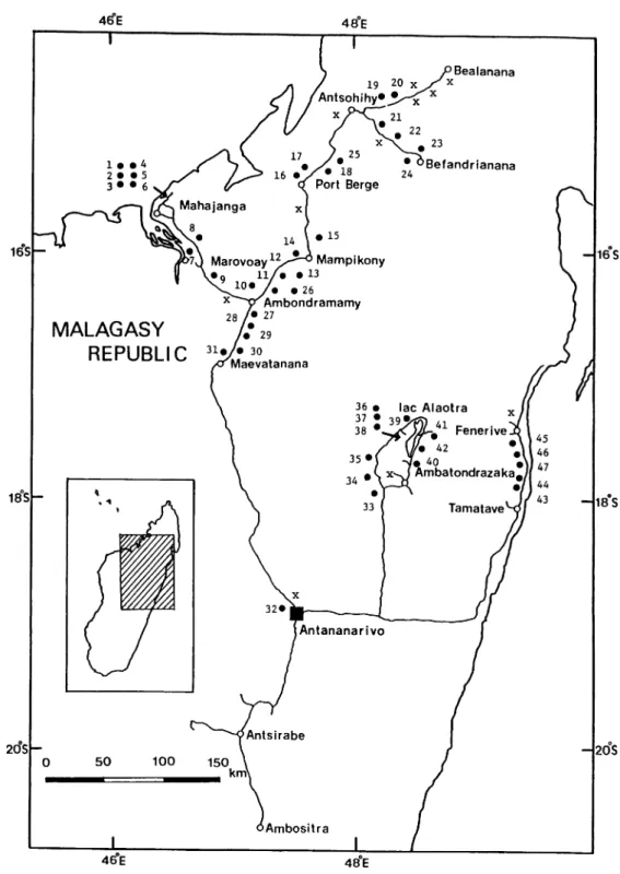
The localities concerned in this trip were northern part of Madagascar. Geographi
cal distribution of wild rice found were briefly illustrated in Fig. 1. In this figure, route
of the trip and the growing areas of the wild rice are given. A numeral in this figure
shows the collection number used in Table 1. There stride over three Faritany, i.e.,
Antananarivo, Mahajanga and Toamasina.
Most of the seed samples collected were divided into two parts, one of which was
deposited in FOFIFA, Madagascar, and another one was carried back to Japan and their
plant- and grain-characters are now being analysed at Kagoshima University.
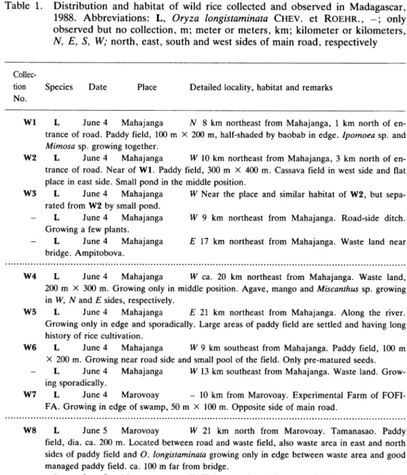
Oryza longistaminata Chev. et Roehr. (Collection Nos.Wl~W47)
Populations of the species were found in a lot of localities, i.e., Mahajanga, Maro
voay, Ambondramamy, Mampikony, Port Berge, Antsohihy, Bealanana, Befandrianana,
Maevatanana, Antananarivo, Ambatondrazaka, lac Alaotra, Tamatave, Fenerive.
Distributions of wild rice collected and only observed were listed up in Table 1. In
this table, collection number, species name, date of collection or observation, detailed
locality and some informations of habitat were described in order of date.
Natural habitats of collected materials concerned in text are exhibited in Figs. 2 to 6
on the whole of the strains. Although some conclusions on the distribution will be drawn
after the experiments made with the use of the materials collected from the several view
points, outlines of habitats of distribution, of environmental and of geo-topographical
conditions have mainly been described. In brief, they had a creeping growth in the pond,
swamp, embankment, small pool, irrigation canal, small stream, and under the shade.
They were sometimes adjacent to the rice field, being separated by an embankment or
not. It may be noticed that population of W37 collected in Anororo (Fig. 5) are growing
sympatrically with the cultivated rice. Moreover, in case of population of W36
(Fig. 5),
it was presumed that it occurred "temporal isolation", because flowering time of strain
growing along the embankment is clearly earlier than that of irrigation canal.
Some morphological characters of unhusked grains
Forty-seven strains of wild rice were collected in this trip, and they were used for
morphological investigations of unhusked grains. Twenty grains were used for the
measurements of each strains.
Measurements were done at length, width and thickness of the respective grains,
centering at the most eminent section of the respective characters. Calculations were
done for the ratios of length to width, of length of thickness, and of width to thickness.
16°S- - 1 6 S
1 8 S
-- 1 8 S
2 0 S - - 2 0 S
46 E 48 E
Fig. 1. Map showing several localities where the wild rice in Madagascar were collected and observed.
Solid line; route of observation, filled circle; collection site, cross mark; growing area where the
samples were observed but not collected, open circle; main town. Code numbers used in the fig
Table 1. Distribution and habitat of wild rice collected and observed in Madagascar,
1988. Abbreviations: L, Oryza longistaminata Chev. et Roehr., -; only
observed but no collection, m; meter or meters, km; kilometer or kilometers,
N, E, S, W; north, east, south and west sides of main road, respectively
Collec
tion Species Date Place Detailed locality, habitat and remarks
No.
Wl L June 4 Mahajanga iV 8 km northeast from Mahajanga, 1 km north of en trance of road. Paddy field, 100 m X 200 m, half-shaded by baobab in edge. Ipomoea sp. and
Mimosa sp. growing together.
W2 L June 4 Mahajanga W 10 km northeast from Mahajanga, 3 km north of en
trance of road. Near of Wl. Paddy field, 300 m X 400 m. Cassava field in west side and flat place in east side. Small pond in the middle position.
W3 L June 4 Mahajanga W Near the place and similar habitat of W2, but sepa
rated from W2 by small pond.
- L June 4 Mahajanga W 9 km northeast from Mahajanga. Road-side ditch.
Growing a few plants.
- L June 4 Mahajanga E 17 km northeast from Mahajanga. Waste land near
bridge. Ampitobova.
W4 L June 4 Mahajanga W ca. 20 km northeast from Mahajanga. Waste land,
200 m X 300 m. Growing only in middle position. Agave, mango and Miscanthus sp. growing in W, N and E sides, respectively.
W5 L June 4 Mahajanga E 21 km northeast from Mahajanga. Along the river.
Growing only in edge and sporadically. Large areas of paddy field are settled and having long history of rice cultivation.
W6 L June 4 Mahajanga W 9 km southeast from Mahajanga. Paddy field, 100 m
X 200 m. Growing near road side and small pool of the field. Only pre-matured seeds. - L June 4 Mahajanga W 13 km southeast from Mahajanga. Waste land. Grow
ing sporadically.
W7 L June 4 Marovoay - 10 km from Marovoay. Experimental Farm of FOFI FA. Growing in edge of swamp, 50 m X 100 m. Opposite side of main road.
W8 L June 5 Marovoay W 21 km north from Marovoay. Tamanasao. Paddy
field, dia. ca. 200 m. Located between road and waste field, also waste area in east and north sides of paddy field and O. longistaminata growing only in edge between waste area and good managed paddy field, ca. 100 m far from bridge.
- L June 5 Marovoay W 58 km east from Marovoay. Dried-up pond, dia 100
m. Growing sporadically in only edge.
W9 L June 5 Marovoay W, E 51 km east from Marovoay and ca. 19 km north
west from Ambondma. Terraced paddy fields, 100 m X 200 m in east side and 200 m X 300 m in west side. Growing in relatively edge-like area in east side and along embankment in west side. Pre-matured seeds. Cultivated rice was almost harvested.
- L June 5 Ambondma W, E 3 km northwest from Ambondma. Large
swamp, ca. 3 km X 300 m. Growing sporadically along the "small stream in swamp", and only pre-matured seeds.
W10 L June 5 Ambondma W, E 16 km northeast from Ambondma. Pond, 20 m X
50 m, separated 50 m from main road by waste land [W]. Small pool, 5 m X 10 m, separated 10 m from main road by waste land [E]. Growing only in edge and only pre-matured seeds. - L June 5 Ambondma E 24 km northeast from Ambondma. Pond, dia 200 m.
Growing sporadically only in edge.
Wll L June 5 Mampikony E 33 km southeast from Mampikony. Pond, 100 m X
200 m, but irregularly shaped. Growing sporadically only in edge. Two living houses adjacent
to pond. Paddy fields were continuously found in east side.W12 L June 5 Mampikony W27 km southeast from Mampikony. Paddy fields, 300
m X 500 m. Growing sporadically along embankment. Mostly eated by animals. Mango, man
go, living houses and baobab in north, west, south and east sides, respectively.
W13 L June 5 Mampikony E 20 km southeast from Mampikony. Pond, 50 m ~ 100 m X 400 m. Growing only in edge and N and S sides. Only pre-matured grains, and moreover only 10 seeds. The most part of plants were eated by catties, even spikelet-neck. Presumably 90% of grains are sterile status.
L June 5 Mampikony E 13 km southeast from Mampikony. Nearly the same
habitat of W13.
L June 5 Mampikony E 12 km southeast from Mampikony. Pond, dia. 100 m. Separated 200 m from main road.
L June 5 Mampikony W 11 km southeast from Mampikony. Swampy area.
Growing sporadically. No seed.
W14 L June 5 Mampikony E Near Mampikony Town. Paddy field, 100 m X 200 m.
Separated by iron fence in east side. Small stream jointed in south side. Too much dry. Only 5
pre-matured seeds. Most of seeds showing sterile.W15 L June 6 Mampikony W 9 km north from Mampikony. Paddy field, 200 m X 1 km, frequently up and down in elevation. Growing sporadically. Cultivating some vegetables
in neighbouring field, separated by embankment.
L
june 6
Mampikony
E} W 16 km north from Mampikony. Road-side paddy
fields. Growing in edge of the fields.
L June 6 Mampikony E 28 km north from Mampikony and 41 km south from
Port Berge Vaovao. Pond. Growing sporadically.
L June 6 Port Berge E, W1 km south from Port Berge Vaovao. Paddy field.
Already harvested. Growing sporadically in only edge.
L June 6 Port Berge N 5 km east from Port Berge Vaovao. Growing in
embankment and waste land over paddy field.
W16 L June 6 Port Berge W 19 km northeast from Port Berge Vaovao and 1 km
inside of west side. Waste land, 400 m X 400 m and pond, dia 100 m in the middle position of
waste land, surrounded by rain-fed paddy field in south side and wild rice in north and east sides. Growing sporadically. Only 10 grains of pre-matured one. Fence in northeast side.W17
L
June 6
Port Berge
W 32 km northeast from Port Berge Vaovao. Paddy
field, irregularly separated from each other. Far from main road by waste land and small stream. Growing sporadically in edge of field and embankment. Almost sterile grains. Only 10 pre-matured grains.
L June 6 Port Berge E, W 39 km northeast from Port Berge Vaovao. Grow
ing in edge of paddy field.
L
June 6
Port Berge
W 37 km northeast from Port Berge Vaovao. Growing
in edge of paddy field.
L June 6 Antsohihy E, W 50 km southwest from Antsohihy and 70 km northeast from Port Berge Vaovao. Growing sporadically in edge of paddy field.
- L June 6 Antsohihy E, W 49 km southwest from Antsohihy. Growing spor
adically in edge of paddy field.
W18 L June 6 Antsohihy E 47 km southwest from Antsohihy. Paddy fields, be
tween main road and sub-road, and east side from sub-road. Small canal, 50 cm width, 10 cm
embankment. Whole areas, 500 m X 1 km. Only 3 matured grains.
- L June 6 Antsohihy E, W 44 km southwest from Antsohihy. Growing in
edge of paddy field. No seed.
- L June 6 Antsohihy E 32 km southwest from Antsohihy. Pond, dia. 50 m.
Growing only in edge. No seed.
- L June 6 Antsohihy E 27 km southwest from Antsohihy. Large paddy field
area. Growing sporadically in the whole areas.
- L June 6 Antsohihy E 26 km southwest from Antsohihy. Swampy area and
small pond.
- L June 7 Antsohihy N 1 km southwest from Antsohihy. Pond, 100 m X 100
m. Growing sporadically in only edge.
W19 L June 7 Antsohihy N 8 km east from Antsohihy. Paddy field, 300 m X 200
m. Small pond near main road. Growing sporadically in the whole areas, but growing in posi tions having deep water and near small pond. Fence, grass land and grass land in east, north and west sides, respectively. After harvested, 2 —5 m height weeds growing and convenient collecting wild rice grains. Seeds of wild rice growing in edge of paddy field, already shed. Presumed intra-population-diversity in view of flowering period, temporal isolation, pollen-and seed-fertilities.
- L June 7 Antsohihy N 32 km east from Antsohihy and 3 km east from junc
tion to Befandrianana. Pond, dia. 100 m.
W20 L June 7 Antsohihy S 34 km east from Antsohihy and 5 km east from junc
tion to Befandrianana. Paddy field, 100 m X 200 m, surrounded by waste land; living houses, banana and mango trees; waste land and water stream in north, east, south and west sides, re spectively. Growing in water stream, 2 m width, 50 cm depth. Small pond, 20 m X 50 m , ad joining north side of stream. Pond and stream separated from main road by waste land, sloped down to the stream.
- L June 7 Antsohihy W 36 km east from Antsohihy. Growing sporadically in
paddy field.
- L June 7 Antsohihy S 39 km east from Antsohihy. Growing sporadically only in edge of paddy field.
- L June 7 Anstohihy N 55 km east from Antsohihy and 3 km east from
Antsahobe. Road-side ditch, 1 m width and 50 cm depth. Growing sporadically.
- L June 7 Bealanana N, S 22 km west from Bealanana. Small pond. Growing
a few plants.
- L June 7 Bealanana N 21 km west from Bealanana. Large basin, keeping wa
ter level as a few meters, 1 km X 10 m. Growing sporadically in the middle area.
- L June 7 Bealanana S 8 km west from Bealanana. Paddy field. Growing a
few plants and sporadically.
- L June 7 Bealanana S 3 km west from Bealanana. Pond, dia. 50 m, and pad
dy field, 100 m X 100 m. Growing sporadically in only edge.
W21 L June 8 Befandrianana S 25 km west from Befandrianana. Paddy field, 50 m to
100 m X 300 m, surrounded by waste land. Having small pond, dia. 20 m. Growing in edge of pond, only 5 plants.
W22 L June 8 Befandrianana N 9 km west from Befandrianana. Paddy field. 200 m X
1 km. Growing 3 positions in the fields. 1 — East part, small pool, dia. 20 m. 2 — West part, dried-up irrigation canal. 3 — South side, small streams, passing through the main road. Three positions separating about 100 m each other. Growing sporadically and mostly shed. - L June 8 Befandrianana N 5 km west from Befandrianana. Pond, dia. 100 m.
W23 L June 8 Befandrianana N 4 km west from Befandrianana. Dried-up paddy field, 500 m X 800 m. Surrounded by slightly elevated upland field, waste land and living houses and home gardens, and main road, in east, north, west and south sides, respectively. Mostly
heavily dried-up and cracked everywhere. Growing sporadically in the whole areas. The seeds
were effectively collected on the earth, which was relatively wet status, having small pools in
somewhere.
W24 L June 8 Befandrianana N 4.5 km west from Befandrianana. Dried-up paddy
field, 300 m X 1 km. Surrounded by waste lands in east, north and west sides and main road
in south side, respectively. Two parts showing growing areas of wild rice. Nearly the same habitat of W23. Small areas of upland field, slightly elevated sugarcane field, surrounded by
fence in north part of the paddy field.
L June 8 Antsohihy W 6 km southwest from Antsohihy. Paddy field. Grow
ing only in edge.
L June 8 Antsohihy E 10 km southwest from Antsohihy. Pond, dia. 100 m.
Growing in edge.
- L June 8 Antsohihy W 13 km southwest from Antsohihy. Paddy field. Grow ing in edge of fields.
W25 L June 8 Antsohihy E 25 km southwest from Antsohihy. Waste lands, 1 km
X 300 m. Small paddy fields are found in the area, having no remarkable embankment. Growing wild rice in bush area in the middle part of th waste land, 10 m X 5 m, about 20 plants. Large ponds located in north and south sides of the waste land.
L June 9 Port Berge £ 4 km south from Port Berge Vaovao. Pond, dia. 50 m. Dried-up but growing a few plants in edge.
W26
L
June 9
Mampikony
M 5 11 km southwest from Mampikony. Paddy fields.
Both fields separated 300 m from main road by waste lands. N — 100 m X 150 m, nearly
ellipse. Growing in all of edges. 5 — irregularly shaped, but nearly ellipse, 100 m X 150 m.
Growing only in north side edge and a few plants.
- L June 9 Mampikony S 20 km southwest from Mampikony. Pond, dia. 100 m,
100 m far from main road.
- L June 9 Mampikony S 39 km southwest from Mampikony. Pond.
W27
L
June 9
Ambondramamy
£ 3 km south from Ambondramamy. Paddy field,
300 m X 200 m, having small stream, 3 m width, in the middle position. The stream flows slowly and connects with main road, through 200 m waste land. Slightly elevated plateau.
Growing along the stream. Surrounded by living houses and fruit trees in the whole areas.
- L June 9 Ambondramamy £ 4 km south from Ambondramamy. Growing
along the stream, but sporadically.
- L June 9 Ambondramamy W 8 km south from Ambondramamy. Pond and paddy field and interior pond. Growing a few plants. Adjacent to uplant rice field. It is said
that the wild rice is growing thickly in the past time.
L June 9 Ambondramamy E 16 km south from Ambondramamy. Pond, dia. 50 m. 100 m interior from main road. Growing only in edge.
L
June 9
Ambondramamy
E 18 km south from Ambondramamy. Paddy
field. Growing in the whole areas, but a few plants.
W28 L June 9 Ambondramamy E 21 km south from Ambondramamy. Paddy field, 100 m separated from main road by waste land, 100 m X 150 m. Surrounded by bush in north and east sides and waste land in south side, respectively. Growing sporadically in edge
and middle position of paddy field, and only pre-matured grains.
W29
L
June 9
Ambondramamy
E 22 km south from Ambondramamy. Slightly
sloped paddy field, 100 m X 200 m, having small water pool in the middle position. Separated
in 4 groups.
W30 L June 9 Ambondramamy E, W 27 km south from Ambondramamy. Small stream across the main road, supported by aluminium bronze tube. Growing sporadically only in edge of stream.
W31 L June 9 Ambondramamy W 28 km south from Ambondramamy. "A dum
pling stuffed with minced pork" shaped paddy field, 100 m in short X 300 m in long sizes, sur rounded by waste land, waste land, living houses and home gardens, and small stream in north, west south and east sides, respectively. Main road separated from small stream, slowly flowing, by low bush, slightly going down. Growing thickly in small streams and sporadically in paddy field. Low bush discharges as defence for animals to paddy field. A spider weaves its web on bush, which keep shedding rice grains.
- L June 9 Ambondramamy W 42 km south from Ambondramamy. Paddy
field in large scale. Growing sporadically in only edge.
- L June 11 Antananarivo -In Antananarivo City. Paddy field. Growing sporadically, only sterile grains.
W32 L June 11 Antananarivo -In Antananarivo City. Paddy field, waste land, and originated water area. Original irrigation water. Hearing informations from the peoples, wild rice, O. longistaminata, migrated here from other places about in 1964. In other place, it is said that wild rice plants decreases year by year. Spread widely, but not so thickly, and showing high seed sterility. Collected only pre-matured grains.
- L June 11 Antananarivo -In Antananarivo City. Befotonana-Ampijoroa. Swampy area, 100 m X 100 m and 100 m X 50 m, water-hyacinth dominant area. Growing in middle position. Highly seed sterile. Using as fish pond. It is said that wild rice is drived away by water-hyacinth year by year.
W33 L June 14 Tsinjoarivo W Tsinjoarivo Village. 29 km wast from
Ambatondraza-ka and 5 km west from Vohidiala. Paddy field. Growing thickly along embankment, slightly high elevated 3 m width X 200 m length. Making a right angle with main road.
W34 L June 14 Morarano E 40 km north from Tsinjoarivo. Morarano Village.
Small stream, sub-road, making a right angle with main road. Pond, adjacent with sub-road and main road, 200 m X 100 m. Growing sporadically and a few plants only in edge and in small island located in the middle part of pond.
- L June 14 Morarano W 8 km north from Morarano, 1 km south from
Saha-mamy. Growing a few plants in edge of electric pole.
W35 L June 14 Ambahitarivo E, W 1 km south from Ambahitarivo and 4 km south
from Antsapanimahazo. E — Paddy field. Growing only along embankment, making a right angle with main road. W — Paddy field, having small stream. Growing sporadically only along boundary of stream and to paddy field. Pond, adjacent to paddy field. Growing only in edge of pond. Surrounded by waste land in the whole paddy fields.
W36 L June 14 Anororo 5 2 km east from Antsapanimahazo, a three-forked road, and 6 km west from Anororo. Paddy field, separated from main road by irrigation ca nals. Growing in irrigation canals and along embankment, slightly elevated about 50 cm height and 1 m width. It was presumed that it occurred "temporal isolation", because flowering time of strain growing along the embankment is clearly earlier than that of irrigation canals. W37 L June 14 Anororo N 6 km east from Antsapanimahazo and 2 km west from
Anororo. Paddy field. Growing sporadically in the middle position. Sometimes, growing sym patrically with Oryza sativa L. (Collection No.C36).
W38 L June 14 Anororo 5 7 km west from Antsapanimahazo and 1 km west from Anororo. Paddy field, adjacent to main road, 200 m width. Growing sporadically along the embankment. The following paddy fields, separated by clear embankment. Growing thickly and sympatrically with a strain of O. sativa (Collection No.C37).
the irrigation canal, 5 m width. Growing sporadically.
- L June 14 Antsapanimahazo W 11 km north from Antsapanimahazo. Growing
in road-side ditch. A few plants.
W39 L June 14 Vohitraivo W 33 km northeast from Antsapanimahazo and 1
km southwest from Vohitraivo. Paddy field. Small stream, flowing parallelly with main road and jointed with other stream, through across main road. Growing thickly and in stream, especially jointing point, making a right angle.
W40 L June 15 Alaotra -In CALA, Complexe Agronomique du lac Alaotra. Experimental Rice Field. Growing sporadically and thickly along irrigation canal and embank ment, respectively. No wild rice in the rice field.
W41 L June 15 Imerimandroso W 3 km south from Imerimandroso and 4 km north from Madiorano. Paddy field. No rice straw and wild rice, already eatened by animals. Put main road between paddy field. Adjacent to forest, mountainous area and lac Alaotra (2 km west) in north side, south and west sides, respectively. 500 m X 300 m paddy field. Picked the seeds up on the earth, along ploughed line and ridge, and furrow. Effective on the furrow and upper side.
W42 L June 15 Madiorano W Turned westward from Rice Mill. Bevondrona Vil
lage. Walked about 2 km westward. Paddy field, irregularly divided by embankment. Growing sporadically and only a few plants. Already the whole seeds shed. Picked the seeds up on the earth, especially embankment.
W43 L June 17 Tamatave W 5 km north from Tamatave. Swamp, 50 m X 200 m.
Surrounded by waste lands in south, west and north sides, and by main road in east side, re spectively. Growing in groups and thickly. Mostly seed sterile, but collected only 5 seeds. W44 K June 17 Tamatave E, W 10 km north from Tamatave. Near broken bridge.
Large river across the main road, making a right angle. E - Paddy field and waste lands lo cated between main road and temporary road. Growing sporadically. W - Large swamp, 300 m X 1 km, having the river in its middle position. Surrounded by forest and living houses. Growing thickly and sporadically in the middle position and along the river, respectively. - L June 17 Tamatave E 11 km north from Tamatave. Paddy field. Growing
sporadically in middle position.
- L June 17 Tamatave E 13 km north from Tamatave. Swamp, 100 m X 200
m. Growing only in edge.
- L June 17 Tamatave E, W 15 km north from Tamatave. Small river across the main road, making a right angle. Inserted large swamps. Growing thickly only along boundary of river and swamp. Showing high seed sterility. No seed collected.
- L June 17 Tamatave E, W 33 km north from Tamatave. Waste land, swamp.
Growing thickly, but showing high seed sterility. Near Indian Sea shore.
- L June 17 Tamatave W 34 km north from Tamatave. Growing a few plants in
a bridge girder, slightly broken. Near paddy field adjacent to sea shore.
- L June 17 Tamatave E 35 km north from Tamatave. River side. Sea water
sometimes flowing up here. Growing a few plants along the bank.
L June 17 Tamatave W 45 km north from Tamatave and 47 km south from
Fenerive. River side. Nearly the same habitat as above.
- L June 17 Fenerive W 38 km south from Fenerive and 54 km north from
Tamatave. Near small village. Small swamp. Growing a few plants only in edge.
- L June 19 Tamatave W, E 47 km south from Fenerive and 45 km north from
Tamatave. River side. Growing sporadically and thickly in west and east sides of main road, respectively. Mainly flowering stage. Showing high seed sterility. Growing many Leguminous trees.
W45 L June 19 Tamatave W, E 57 km south from Fenerive and 35 km north from
Tamatave. River side and swamp. River - Growing thickly and sporadically in east and west
sides of main road, respectively. Only along the coast. Swamp - Growing as group-shaped
with other plant kind in heavy swamp, 50 cm deepness in east side. A few plants sporadically
in west side, surrounded by waste land, paddy field, paddy field and river in east, south, west
and north sides, respectivly. 1 km X 300 m.
W46 L June 19 Tamatave W, E 59 km south from Fenerive and 33 km north from
Tamatave. River side and swamp. River side - Only a few plants in east side and only south side-bank, many plants in west side and south and north-banks. Nearest plant from Indian Sea growing sbout 150 m from sea shore. Prospective as salt resistance. Swampy area in east side
- Nearly the same habitat, but adjacent with bush and coconut trees, and separated by them
from Indian Sea. Swampy area in west side - Growing only a few plants sporadically, sur
rounded by waste land (50 m width), sugarcane field, paddy field and paddy field, 100 width, in east, south, west and north sides, respectively. 100 m X 200 m. Only pre-matured grains.
W47 L June 19 Tamatave W, E 60 km south from Fenerive and 32 km north from
Tamatave. River side. Growing sporadically only along the bank. Nearest plant located about 200 m from Indian Sea shore, and growing along the bank extending over 100 m, between most east plant and bridge. West side - Also only along the bank extending over 100 m. - L June 19 Tamatave E 25 km north from Tamatave. Growing only a few
plants along small stream.
L June 19 Tamatave W, E 18 km north from Tamatave. Growing thickly
along small stream. Showing high seed sterility.
L June 19 Tamatave E, W 15 km north from Tamatave. Small stream across
the main road, making a right angle. Inserted large swampy areas. Growing thickly along in
distinct boundary between stream and swampy area. Cut off well as feed for animals.
L June 19 Tamatave W, E 10 km north from Tamatave. Near broken bridge. E - Paddy field and waste lands located between main road and supplementary road. Grow
ing sporadically. W - Large swamp, having the river in its middle position. Surrounded by
forest and living houses.L June 19 Tamatave W 5 km north from Tamatave. Near airport. Swamp, 50
m X 200 m. Surrounded by waste lands in south, west and north sides, and by main road in
east side, respectively. No seed.
L June 19 Tamatave W 1 km north from Tamatave. Small pond. Growing a
Wl Coco FOFIFA
"EH
Coco Baobab W10 Leersia sp.••• W2
Baobab Wll Agave W12 Mango Ca. 200 mFig. 2. Sketch maps (1) of habitats of wild rice population. Circle dot [•] shows wild rice, Oryza longi
staminata Chev. et Roehr., C; cultivated rice field, P; pond or small water pool, R; road, V; riv
er or small stream, S; swamp, E; embankment, F; forest, W; waste land, G; grass land, H;
Ca. 200 m
Fig. 3. Sketch maps (2) of habitats of wild rice population. Circle dot [•] shows wild rice, Oryza longi
staminata Chev. et Roehr., C; cultivated rice field, P; pond or small water pool, R; road, V; riv
er or small stream, I; irrigation canal, E; embankment, F; forest, W; waste land, G; grass land,
W24 W26 Sugarcane t J Fence W27 U I I *E W28 F
TF
RW29
F
v W30u
W32*.*// Riverhead
/'
Ca. 200 m
Fig. 4. Sketch maps (3) of habitats of wild rice population. Circle dot [•] shows wild rice, Oryza longi
staminata Chev. et Roehr., C; cultivated rice field, P; pond or small water pool, R; road, V; riv er or small stream, I; irrigation canal, E; embankment, F; forest, W; waste land, G; grass land, H; house, U; upland cultivated field.
W33 W35 E
' •©
W36 I W37 W38 E ' Rice Ear P i l e • . « «• » W39 ,\U h - i Ca. 200 m W41 W40 V R Bamboo Mountain . . E MountainFig. 5. Sketch maps (4) of habitats of wild rice population. Circle dot [•] shows wild rice, Oryza longi
staminata Chev. et Roehr., C; cultivated rice field, P; pond of small water pool, R; road, V; riv
eror small stream, I; irrigation canal, E; embankment, F; forest, W; waste land, G; grass land.
Livestock Rice Ear Pile H H H H H Rice Mill
•^oir
H H Ca. 200 m WA6 Sugarcane U C V/India Sea Shore
Indian Sea Shore
Fig. 6. Sketch maps (5) of habitats of wild rice population. Circle dot [• ] shows wild rice, Oryza longi
staminata Chev. et Roehr., C; cultivated rice field, P; pond or small water pool, R; road, V; riv
er or small stream, S; swamp, E; embankment, F; forest, W; waste land, G; grass land, H; house, U; upland cultivated field.
the whole grains. Although the weight of unhusked grains was also measured, this char
acter was omitted in the present paper.
The results are given in Table 2. Lengths for the individual grain level ranged from
9.95 mm (W45) to 5.80 mm (W27). In the strain level, the longest (8.83 mm) was
obtained in W23, followed by W22 (8.75 mm) and W16 (8.74 mm). The shortest (6.72
mm) was noted in W9, followed by Wll (6.85 mm) and W10 (6.99 mm).
Average and
its standard deviations in the whole strains were found to be 7.93 ±0.52.In the standard deviations of each strain, i.e., those showing the intra-population's
variations, the largest (0.69) was obtained in W5 and W30, followed by W27 (0.66). The
smallest (0.26) was noted in W15, followed by W10, W28 and W42 (0.32). Average and
its standard deviations in the whole strains were found to be 0.46 ±0.11.Widths for the individual grain level ranged from 3.05 mm (W46) to 1.70 mm (Wl,
Wll and W27). In the strain level, the widest (2.69 mm) was obtained in W23, which
was the same as in case of the length, followed by W22 (2.67 mm), which was also the
same as in case of the length, and W45 and W46 (2.66 mm). The narrowest (1.98 mm)
was noted in W2, followed by W5 (1.99 mm), and Wl and W27 (2.00 mm). Average
and its standard deviations in the whole strains were found to be 2.26±0.19.
In the standard deviations of each strain, the largest (0.25) was obtained in W20,
followed by W45 (0.23) and W17 (0.22).
The smallest (0.10) was noted in No. 24, fol
lowed by W5 and W6 (0.11). Average and its standard deviations in the whole strains
were found to be 0.16±0.03.In comparison with two components, i.e., length and width of unhusked grains, the
following tendencies became clear, as illustrating in Fig. 7. In this figure, the respective
strains were plotted in the respective values in both characters. The relatively small
groups were detected, i.e., the shorter in length and narrower in width (1) and the short
er in length (1). Six strains, i.e., W5, W8, W9, W10, Wll and W27, belonged to the for
mer group (2). Five strains, i.e., Wl, W2, W3, W4 and W6, belonged to the latter group
(2). The whole of them were collected in northwest part of Madagascar, i.e., Mahajan
ga, Marovoay and Ambondramamy.
On the contrary, strains collected near Befandrianana, i.e., W22, W23, showed the
longer in length and wider in width .
Morever, five strains, i.e., W43, W44, W45, W46 and W47, in other words, the
whole of strains in Tamatave area, showed relatively the longer in length and wider in
width.
Thicknesses for the individual grain level ranged from 2.10 mm (W45), which was
the same as in case of the length, to 1.05 mm (W25). In the strain level, the thickest
(1.83 mm) was obtained in W45, followed by W46 (1.82 mm) and W44 (1.68 mm). The
thinnest (1.36 mm) was noted in W26, followed by W27 (1.37 mm) and W24 (1.40 mm).
Table 2・ Six morphologlCal characters of unhusked grains of Madagascar, 0・ longiStaminata
;oooi'" S駕.cTes lemn:t,h 器 Th.iikmn,ess L′W - W什
W 1 2001 7.97±0.64 W 2 2002 7.82±0,42 W 3 2003 8.18土0.48 W 4 2004 7.77土0.47 W 5 2005 7.18±0.69 W 6 2006 7.43土0.47 W 7 2007 7.94土0.34 W 8 2008 7.OS量O.36 W 9 2009 6,72±0.32 WIO 2010 6.99±0.32 Wl1 2011 6.85±0.43 W12 2012 8.23±0,51 W13 2013 8,13±0.36 W14 2014 8.20土0.47 W15 2015 8.12土0.26 W16 2016 8.74土0.38 W17 2017 8.65 ±0.44 W18 2018 7.80±0.55 W19 2019 7.73±0.50 W20 2020 7.52 ±0.53 W21 2021 7.72±0.53 W22 2022 8.75 ±0.53 W23 2023 8.83 ±0.37 W24 2024 7.92 ±0.44 W25 2025 7.41 ±0.44 W26 2026 7.62 ± 0.45 W27 2027 7.22土0.66 W28 2028 7.55 ±0.32 W29 2029 8.13 ±0.57 W30 2030 7.84±0.69 W31 2031 7.78±0.51 W32 2032 7. 48 ± 0.62 W33 2033 7.49±0.38 W34 2034 8.50土0.42 W35 2035 7.82 ± 0. 39 W36 2036 8.62土0.40 W37 2037 8.36±0.55 W38 2038 8.38±0.39 W39 2039 7.91 ±0.35 W40 2040 8.67 ±0.37 W41 2041 7,69 ±0.49 W42 2042 8. 16 ±0.32 W43 2043 8,30 ± 0.38 W44 2044 8.60土0.40 W45 2045 8,55 ±0.65 W46 2046 8. 16 ±0.34 W47 2047 8.33 ± 0.40 2.00±0.17 1.98±0.18 2.06±0.16 2.lo主o.17 1.99±0.ll 2.lo主o.ll 2.19土0.16 2.05士0.14 2,03±0.12 2.09±0.16 2.08土0.19 2.15±0.19 2.22±0.16 2.20±0.16 2.14±0.14 2,58±0.15 2.58±0.22 2.43±0.14 2.64±0.15 2.32±0.25 2.39±0.20 2.67±0.19 2.69±0.16 2.11±0.10 2.23±0.16 2,09土0.17 2.00±0.16 2.29±0.14 2.24±0.19 2.29±0.52 2.17土0.15 2.12±0.17 2.12±0.20 2.23土0.12 2.26±0.19 2.22土0.14 2.37±0.15 2.30±0.12 2.29土0.16 2.38土0.16 2.23±0.16 2.26±0.14 2.42±0.19 2.47±0.12 2.66土0.23 2,66±0.18 I.52±0.12 1.46土0.09 1.52±0.08 1.51 ±0.09 1.44土0.ll I.43±0.ll 1.49±0.17 I.43±0.09 1.44±0.10 1.41±0.08 1.43±0,08 1.52±0.08 I.56±0.09 1.51±0,12 1.41±0.10 1.64±0,12 1.63土0,ll 1.61 ±0.07 1.65EO.10 1.44±0.10 1.43±0.16 1.56±0.15 1.56±0.12 1.40±0.09 1.42±0.13 1.36±0.07 1.37±0.08 1.55±0.10 1.43±0.10 1.52±0.ll 1.42±0.ll 1.47±0.12 1.42±0.09 1.56±0.15 1.51土0.07 I.55±0.12 1.52土0.ll 1.56±0.09 1.56±0.09 1.62±0,10 1,58±0.12 1.55土0.ll 1,57土0.18 1.68土0.14 1.83士0.15 1.82土0.12 4.02±0,43 3.99±0.42 3,99±0.31 3.72±0.28 3.62±0,35 3.55土0.23 3.65±0.25 3.44±0.30 3.32±0.34 3.36±0.29 3.32±0.32 3.85±0.36 3.68±0.32 3.76±0.36 3.81土0.26 3.40±0.26 3,37±0.34 3.22±0.23 3.16土0.26 3.27±0.30 3.26±0.32 3.30±0.33 3.30±0.26 3.77±0.21 3.34±0.32 3,67土0.34 3.62±0,33 3.31 ±0.26 3.65土0.37 3,43±0.32 3.60土0.24 3.55土0.37 3.56土0.31 3.83±0.28 3.49±0.30 3.90土0.26 3.54±0,25 3.66土0.25 3.48土0.31 3.66±0.26 3.47±0.34 3.62±0.25 3.44±0.22 3.49±0.15 3.23±0.31 3.09土0.23 5.29±0,56 5.39±0.41 5.39±0.34 5.16±0.45 5.01土0.46 5.22±0.39 5.40±0.58 4.95±0.40 4.70±0.45 4.98土0.38 4.79±0.36 5.43±0.48 5.22±0,23 5.46土0.46 5.77±0.36 5.35±0.48 5.33±0.44 4,86±0.44 4.69±0.37 5.26±0,56 5,48±0.71 5.65±0.66 5.71±0.54 5.70土0.46 5.27±0.58 5,63土0.36 3.28±0.51 4.91土0.ll 5.71±0.55 5.19土0.63 5.51 ±0.49 5.12±0.48 5.30土0.47 5.50±0,52 5.19±0.29 5.58iO.38 5.53±0.56 5.39±0.35 3.09±0.28 3.38±0.45 4.89±0.32 5.29±0.38 5,34土0.45 5.15土0.39 4.70±0.50 4.51土0.34 1.33±0.13 1.36±0.14 1.36±0.ll 1.39土0.13 1.39土0.12 1.47±0.10 1.49土0.20 1.45土0.16 1.42±0.13 1.49±0.12 1.45±0.16 1.42±0.15 1.43±0.13 1.46土0.15 1.52土0.13 1.58±0.14 1.59±0.17 1.52土0.12 1.49±0.13 1.62±0.21 I.69±0.22 1.72±0.22 I.74土0.19 1.51±0.ll 1,59土0.21 1.54±0.12 1.47±0.16 1.49土0.ll I,57±0.15 1.51±0,14 1.54±0.13 I.45±0.17 1,50±0.18 1.44±0.52 1.50±0.12 1.44±0.ll 1,56±0.14 1.47±0.10 1.47±0,ll 1.47土0.ll 1.42±0.16 1.46±0.ll 1.56土0.14 1.48土0.12 1,46±0.14 1.47土0.16 2.38±0.16 1.49±0.12 3.52土0.23 5.63±0.55 1.60±0 Whole Avelage 7.93±0.52 2.26±0.19 1.52土0.10 3.54±0.26 5.26±0.30 1.50土0.09
Length (mm) 8.8 40 36 • 16 # • 23 •
22#
8.6 •3<#
44 • 1745#
8.4 12 • 38- 37 • • 47 14 • 43 8.2 -3m#13 #*2
• • •15#
29
46« 8.0 1 * 24 •• 7
39
•31
•
#30
7.8•2
4 • • 21 #19 -41#
• 18 26 a 7.6 336#<32
28 • • 20 7.4 27 • # 25 7.2 • 5 8 • 7.0•l0
•11 6.8 1 9 • L _ t 1 1 1 1 1 2.0 2.1 2.2 2.3 2.4 2.5 2.6 2.7 Width (mm)Fig. 7. Relation between length and width of unhusked grains in mm, O. longistaminata. Vertical axis; length, abscissa; width. Code numbers used in the figure are corresponding to the collection num
In the standard deviations of each strain, the largest (0.18) was obtained in W43,
followed by W7 (0.17) and W21 (0.16).
The smallest (0.07) was noted in W18, W26
and W35. Average and its standard deviations in the whole strains were found to be
0.11±0.33.Ratios of length to width (abbreviated as L/W in the table) for the individual grain
level ranged from 4.86 (W3) to 2.59 (W19). In the strain level, the largest (4.02) was
obtained in Wl, followed by W2 and W3 (3.99). The smallest (3.09) was noted in W46,
followed by W19 (3.16) and W18 (3.22). Average and its standard deviations in the
whole strains were found to be 3.54±0.26.In the standard deviations of each strain, the largest (0.43) was obtained in Wl, fol
lowed by W2 (0.42), and W29 and W32 (0.37). The smallest (0.15) was noted in W44,
followed by W24 (0.21) and W43 (0.22). Average and its standard deviations in the
whole strains were found to be 0. 29 ±0.05.Ratios of length to thickness (abbreviated as L/T in the table) for the individual
grain level ranged from 7.54 (W22), which was the same as in case of the width, to 3.87
(W21). It is noticeable that strain No.W21 showed the nearly largest value (7.17) and
the smallest value (3.87) in the whole strains ( = 47). In other words, it showed the large
intra-population's variation. In the strain level, the largest (5.77) was obtained in W15,
followed by W23 and W29 (5.71). The smallest (4.69) was noted in W19, followed by
W9 and W45 (4.70). Average and its standard deviations in the whole strains were found
to be 5. 26±0.30.In the standard deviations of each strain, the largest (0.71) was obtained in W21,
followed by W22 (0.66) and W30 (0.63). The smallest (0.11) was noted in W28, followed
by W13 (0.23) and W39 (0.28). It is noticeable that the value was very small in W28.
Average and its standard deviations in the whole strains were found to be 0.45 ±0.10.
Ratios of the width to thickness (abbreviated as W/T in the table) for the individual
grain level ranged from 2.12 (W22), which was the same as in case of the ratio of the
length to thickness (L/T), to 1.03 (Wl), which was the same as in case of the width. In
the strain level, the largest (1.74) was obtained in W23, which was the same as in cases
of the length and width, followed by W22 (1.72), which was also the same as in cases of
the length and width, and W21 (1.69). The smallest (1.33) was noted in Wl, followed by
W2 and W3 (1.36). Average and its standard deviations in the whole strains were found
to be 1.50±0.09.In the standard deviations of each strain, the largest (0.52) was obtained in W34,
which was noticed as the particularly large value in the whole strains, followed by W21
and W22 (0.22), which were the same as in case of the ratio of length to thickness (L/T).
The smallest (0.10) was noted in W6 and W38.
Average and its standard deviations in
the whole strains were found to be 0.14±0.03.Summary
During the trip from May to June in 1988 in Madagascar, 47 strains of wild rice spe
cies, i.e., Oryza longistaminata Chev. et ROEHR., were collected, and several popula
tions of them were observed. Their localities and habitats were reported in detail. Main
locality names are as follows; Mahajanga, Marovoay, Ambondramamy, Mampikony,
Port Berge, Antsohihy, Bealanana, Maevatanana, Antananarivo, Ambatondrazaka,
Tamatabe. They have a creeping growth in pond, swamp, embankment, irrigation canal,
small stream. Some populations are growing sympatrically with cultivated species, Oryza
sativa L., and are showing temporal isolation.
From the analyses of unhusked grain characters, average values and the standard
deviations in the whole strains were found to be 7.93 mm ±0.52, 2.26 mm ±0.19, 1.52
mm ±0.10, 3.54 ±0.26, 5.26 ±0.30 and 1.50 ±0.09 in length, width, thickness, ratios of
length to width, of length to thickness, and of width to thickness, respectively.
In the analyses of the data obtained in the field surveies, morphological and
geneti-cal characters, ecotypic and varietal differentiations could be discussed in the future.
References
1) Bied-Charreton, M. et al.: Notice explicative des Cartes des conditions
geographi-ques de la mise en valeur Agricole de Madagascar. I. Potential des unites physigeographi-ques.
ORSTOM-Paris, Antananarivo, pp. 187 (1981)
2) Hamon, S.: Bilan des prospections: Cafe, gombo, mil, panicum, riz. l'ORSTOM et
sa Contribution a l'Etude des Ressources Genetiques en Afrique, pp. 13 (1984)
3) Katayama, T. C, R. Xavier R., A. Nakagama and A. Sumi: Distribution and
![Fig. 2. Sketch maps (1) of habitats of wild rice population. Circle dot [•] shows wild rice, Oryza longi staminata Chev](https://thumb-ap.123doks.com/thumbv2/123deta/6407372.1107670/12.754.127.653.134.752/sketch-habitats-population-circle-shows-oryza-longi-staminata.webp)
![Fig. 3. Sketch maps (2) of habitats of wild rice population. Circle dot [•] shows wild rice, Oryza longi staminata Chev](https://thumb-ap.123doks.com/thumbv2/123deta/6407372.1107670/13.757.103.633.141.783/sketch-habitats-population-circle-shows-oryza-longi-staminata.webp)
![Fig. 4. Sketch maps (3) of habitats of wild rice population. Circle dot [•] shows wild rice, Oryza longi staminata Chev](https://thumb-ap.123doks.com/thumbv2/123deta/6407372.1107670/14.754.123.651.134.769/sketch-habitats-population-circle-shows-oryza-longi-staminata.webp)
![Fig. 5. Sketch maps (4) of habitats of wild rice population. Circle dot [•] shows wild rice, Oryza longi](https://thumb-ap.123doks.com/thumbv2/123deta/6407372.1107670/15.757.100.629.166.771/fig-sketch-habitats-population-circle-shows-oryza-longi.webp)
![Fig. 6. Sketch maps (5) of habitats of wild rice population. Circle dot [• ] shows wild rice, Oryza longi staminata Chev](https://thumb-ap.123doks.com/thumbv2/123deta/6407372.1107670/16.754.145.671.158.793/sketch-habitats-population-circle-shows-oryza-longi-staminata.webp)

