88
International review for spatial planning and sustainable development, Vol.3 No.1 (2015), 88-97 ISSN: 2187-3666 (online)
DOI: http://dx.doi.org/10.14246/irspsd.3.1_88
Copyright@SPSD Press from 2010, SPSD Press, Kanazawa
Spontaneous Urban Agricultural Lands as Potential Green Open Space
Min, Kyung-chan¹, Kim, Jee-young¹ and Son, yong-hoon2*
1 Dept. of Landscape Architecture, Graduate School of Environmental Studies, Seoul National University
2 Graduate School of Environmental Studies, Seoul National University
* Corresponding Author, Email: [email protected] Received 12 January, 2014; Accepted 23 July, 2014
Key words: Urban agricultural land, Non building area, Types of agricultural land, Gwanak-gu of Seoul,
Abstract: Seoul City promotes ‘Urban Agriculture’ by consistently building vegetable garden parks and community vegetable gardens and inviting citizens to participate in the new movement. However, far too little attention has been paid to proper evaluations on the existing spontaneous agricultural lands, despite the fact that some agricultural lands remain neglected or public lands are being illegally used by individuals. Our research area, Gwanak-gu, is a representative case with many spontaneous agricultural lands that carry various risk factors such as that of disaster, environmental pollution, and degradation of the landscape in the city. The purpose of this study is to categorize the types and problems of agricultural lands in Gwanak-gu through a field survey. By using Geographic Information System and satellite images, field surveys and interviews, we showed the current distribution status. As a result, 45 areas of agricultural lands, mainly located around the edges of Mt.
Gwanak, were found. The agricultural lands were classified into six categories: three of those, flat Vegetable Garden, Edge Vegetable Garden and Private Weekend Farm, are well managed, while three types, Farm in Forest Edge, Farm in Forest, Shabby Farm, are in poor condition. The study discusses what caused lands to be either well managed or ruined. This study has an objective to discover whether spontaneous agricultural lands have the possibility to become community open spaces.
1. BACKGROUND 1.1 Purpose of Research
Gwanak-gu (District) is located in the southern part of Seoul with an area of 29.57km2 and 526,341 residents as of the year 2012. Seoul National University is situated in the district and Gwanak Mountain, an Urban Natural Park (632m2), is located at its south.
Gwanak District in the 1960s was mainly a mountainous area surrounding the Gwanak Mountain and its valleys. With rapid urbanization along with the building of Nambu Sunhwan Doro (A road circling the southern part of Seoul) in the 1970s, relatively gentle slope areas on the mountains turned into residential areas. The residents who moved first to the
area at the time were mainly poor people and some of them used the woodlands surrounding the residential area for cultivation without proper authorization of public offices.
Presently, the park green ratio of Gwanak-gu is 46.5%, which is very high in Seoul, and yet, mountain occupies 95% of this park green. Planned park areas, designated areas for redevelopment and development restriction zones of this mountainous area are usually neglected and used illegally for personal cultivation activities.
Gwanak-gu has various types of urban agricultural lands in the neglected areas. These agricultural lands have spontaneously come into being. The purpose of the farmland varies from self-sufficient use to leisure. These unauthorized agricultural lands on the hills are causing difficulties for administrators, such landslide from forest destruction and degradation of the city landscape. In addition, since the use of fertilizers and agricultural pesticides on agricultural lands are out of control, they are also a risk factor regarding the environmental pollution of the city. On the other hand, considering the new ideas of temporary usage for the restricted areas, there are social, economic and functional values in urban farming.
The purpose of this study is to limit the risk factors of illegal cultivation on the city by finding out and categorizing the characteristics of city farmland in Gwanak-gu. Through investigation of cases and in searching for the possibility of providing green open spaces in an effective manner, an efficient management plan for the green spaces can be suggested.
Figure 1. Location of Gwanak-gu
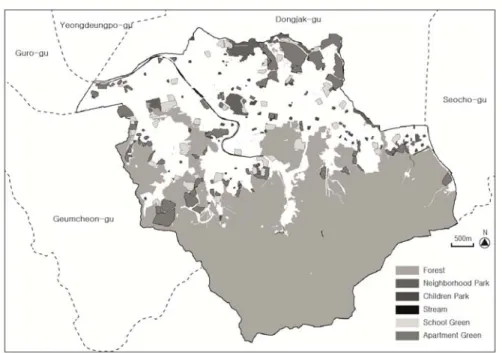
Figure 2. Green spaces in Gwanak-gu
1.2 Method of Research
This study deals with the city farms located in Gwanak-gu, with a size of over 100㎡ that can be identified by satellite. This study draws out current distribution status with GIS and collects data through field survey to identify geographical characteristics.
In the field survey, the survey sheet is filled with such items as location, type, position, accessibility, visibility and state of management. At the same time interviews with the users were also conducted. Agricultural lands were classified in consideration of sustainability and functionality for the local community. Lastly, effective management alternatives are suggested.
First, overall agricultural lands were investigated using satellite images and GIS. Agricultural lands identifiable by satellite in Gwanak-gu consisted of 45 areas, mainly located around the neighbourhood of Gwanak Mountain.
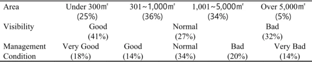
The survey sheets containing the items are indicated in Table 1. After the field trip, additionally collected data such as photos, interviewed information and other significant facts were recorded in the survey sheets and land ownership status and regulation information were later procured through the forest land cadastre (register).
Table 1. Survey Items
General Location / Area
Land Ownership Public / Private / Etc (Mixed / Unseizable) Placement Mountain Plain / Mountain Slope / Valley /
Nearby Residential / Urban Stream / Urban Plain Farmland Form Dense / Scattered / Mixed other use
Main Crop Cabbage and Lettuce / Pepper and tomato / Bulbs / Flowers User Behaviour Farming / Rest / Take a walk (Number of User)
Accessibility Easy / Normal / Hard
Visibility Good / Normal / Bad
Natural State of Surrounding Very good / good / normal / bad / very bad Degree of Pollution Very good / good / normal / bad / very bad
General Location / Area
Management Condition Very good / good / normal / bad / very bad
1.3 Related Studies
Lately, with urban farming standing out as a new solution to the problems of cities and a place for leisure, plenty of research has been conducted on the development and utilization of farmland in the cities.
Kim, Soo Bong (2002), Song, In Joo and Jin, Yoo Lee (2003) and Jang, Don Hun (2009) researched the expected effects of the development of urban farming in terms of ecology and public interest. Yet, their research mainly dealt with the correlation of the two words, ‘city’ and ‘agriculture’ and recognized urban farming as ‘quasi-natural areas’ that contribute to the cities’ environmental problems. More recently, research on the concept of urban agriculture for non-commercial cultivation for leisure by city residents in the neighbouring parts of a city has been increasing (Hwang, Jung-im, et al., 2010).
Kang, Ki Nam, et al. (2007), through questionnaire survey on the usage of vegetable gardens, conducted research on farmland management methods under citizen autonomy and Park, Yong Bum (2008) tried to analyze the characteristics of accessibility, popularity and sustainability according to six categories of urban farming, residential type, farm type, school type, public welfare facilities type, park type and commercial-industrial type. Kim, Ok Jin (2009) established the concept of city farmland, conducted value analysis on Suncheon city through GIS analysis and researched a plan to utilize and manage city farmland.
Summarizing the previous studies, we see the authors mainly have focused on the positive aspect of the introduction of urban farming, while the effects that city agricultural lands under poor status had were generally overlooked. In addition, most research was conducted on large areas through GIS and questionnaire surveys with e-mails, and lacked practical surveys.
Their alternatives are macroscopic and too general so it is difficult to consider them as reflecting the distinct problems of subject lands.
This study has distinctive meaning in that it classifies the subject lands into categories through detailed field investigations and analysis on the management status. Then it suggests proper alternatives to each category regarding whether to maintain or restore them.
2. STUDY RESULT
2.1 Distribution and General Conditions
Figure 3 indicates the distribution of Agricultural lands in Gwanak-gu.
Table 2 is the summary of field survey results. Agricultural lands with a size over 300m2 are 75%. Agricultural lands with a size over 300m2 are used by over 10 people and because they occupy a large area, many are located in urban natural park or redevelopment areas. Management statuses of agricultural lands vary widely according to location and user’s attitude. On the other hand, each farmland with a size less than 300 m2 is managed by individuals or less than five people who live in the vicinity of the agricultural lands, and they are relatively well managed.
About 65% of agricultural lands are located in mountain areas, mainly on the slope of lower parts of the mountain. Agricultural lands scattered around trails or in the mountains are generally in very poor states. While agricultural lands located around residential areas are generally in good states, agricultural lands in redevelopment areas are in very poor states.
As for ownership of the lands, over 70% of agricultural lands are privately owned and large-size lands are owned by religious organizations or family clans. Many actual cultivators are not the owners of the lands. There have been some conflicts on the selling and buying illegally of cultivating rights. In most cases cultivation activities are legally prohibited as redevelopment areas or planned park areas account for all except only 11%
of the general area. While most agricultural lands have good (53%) or normal (20%) accessibility. Management conditions vary such as Bad and Very Bad (34%), Normal (34%), Good and Very Good (32%).
Figure 3. Distribution of agricultural lands
Table 2. General conditions of agricultural lands
Area Under 300㎡
(25%) 301~1,000㎡
(36%) 1,001~5,000㎡
(34%) Over 5,000㎡
(5%) Placement Plain in Mt.
(14%)
Slope of Mt.
(41%)
Nearby Valley (9%) Nearby Residential
(23%)
Urban Plain (9%)
Urban Stream (5%)
Ownership Public
(12%)
Private (70%)
Undefined (18%)
Region Park Area
(69%)
General Area (11%)
Redevelopment Area (20%) Agricultural
lands’ Form
Concentration (80%)
Scattering (9%)
Mixed Use (11%)
Accessibility Easy
(53%)
Normal (20%)
Hard (27%)
Area Under 300㎡
(25%) 301~1,000㎡
(36%) 1,001~5,000㎡
(34%) Over 5,000㎡
(5%)
Visibility Good
(41%)
Normal (27%)
Bad (32%) Management
Condition
Very Good (18%)
Good (14%)
Normal (34%)
Bad (20%)
Very Bad (14%)
2.2 Classification
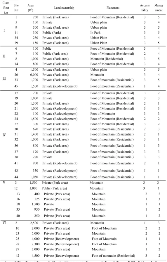
45 Agricultural lands were classified into six types based on their management state and other conditions (such as location, size, and usage).
Table 3 shows the classification of 45 agricultural lands. Well-managed agricultural lands have three types (Figure 4): Flat Vegetable Garden, Edge Vegetable Garden and Weekend Farm. These types are located in or near residential areas and are easily manageable flat land or lower slopes at the foot of the mountain. Land owners and cultivators live in the vicinity and these lands have characteristics of easy accessibility. Some agricultural lands are rented to cultivators in small sections.
Figure 4. Well-managed Agricultural lands
2.2.1 Agricultural lands in poor condition
Agricultural lands in poor condition have three types (Figure 6): Farm in forest edge, Farm in Forest and Shabby Farm. These types are randomly- scattered agricultural lands. Most are strewn all over the forests of the mountain. Forest destruction and environmental pollution is under way in these areas.
Mostly located on the slope, they take the form of terraces and there are cut down trees and illegally thrown garbage in some places. It has poor accessibility. Sometimes they are located in shabby surrounding environments that are fairly large in scale. Management status of the
agricultural lands is not good and the degree of pollution of their surroundings is high.
Figure5. Agricultural land in poor condition
Table 3. Classification for 45 agricultural lands Class
ificat ion
Site No
Area
(㎡) Land ownership Placement Accessi
bility Manag
ement
Ⅰ
1 250 Private (Park area) Foot of Mountain (Residential) 3 5
5 100 Private Urban plain 3 4
9 300 Private (Park area) Urban plain 3 5
11 300 Public (Park) In Park 3 5
34 230 Private (Park area) Urban Plain 3 4
39 150 Private (Park area) Urban Plain 3 5
Ⅱ
6 100 Public Foot of Mountain (Residential) 3 4
7 100 Public (Park area) Foot of Mountain (Residential) 2 4
8 1,000 Private (Park area) Mountain (Residential) 3 5
14 800 Private (Park area) Foot of Mountain (Residential) 3 4
Ⅲ
4 1,500 Private (Park area) Urban plain 3 5
26 6,000 Private (Park area) Mountain 3 4
33 1,700 Private (Park area) Foot of mountain (Residential) 3 5 45 1,500 Private (Redevelopment) Foot of mountain (Residential) 1 4
Ⅳ
17 200 Private Foot of Mountain (Residential) 3 2
19 1,000 Private Foot of Mountain (Residential) 3 3
20 1,300 Private (Park area) Foot of Mountain (Residential) 2 1 21 1,000 Private (Redevelopment) Foot of Mountain (Residential) 3 3
22 100 Private (Redevelopment) Foot of Mountain 3 3
24 1,500 Private (Redevelopment) Foot of Mountain (Residential) 2 2 27 300 Private (Park area) Foot of Mountain (Residential) 3 2 30 670 Private (Park area) Foot of mountain (Residential) 2 3 31 1,400 Private (Park area) Foot of mountain (Residential) 2 1 32 1,000 Private (Park area) Foot of mountain (Residential) 3 1 36 800 Private (Park area) Foot of mountain (Residential) 1 3 37 170 Private (Park area) Foot of mountain (Residential) 3 3
38 220 Private Foot of mountain (Residential) 3 3
41 900 Private (Redevelopment) Foot of mountain (Residential) 2 1 43 350 Private (Redevelopment) Foot of mountain (Residential) 1 1 44 1,050 Private (Redevelopment) Foot of mountain (Residential) 1 1
Ⅴ 3 1,500 Private (Park area) Mountain 3 3
12 1,000 Public (Park area) Mountain 3 3
13 400 Private (Park area) Mountain 2 2
16 125 Private (Park area) Mountain 1 3
18 1,500 Private Mountain 1 1
35 950 Private (Park area) Mountain 1 2
40 250 Private (Park area) Mountain 1 2
Ⅵ 2 2,500 Private (Park area) Mountain 1 3
10 2,000 Private (Park area) Foot of Mountain 2 2
23 5,000 Private (Park area) Mountain 2 2
25 4,000 Private (Redevelopment) Foot of Mountain 1 1
28 2,300 Private (Redevelopment) Foot of Mountain 1 3
29 3,000 Private (Park area) Mountain 1 2
42 4,500 Private (Redevelopment) Foot of mountain (Residential) 3 2 - Accessibility : 3(easy).2(normal),1(hard) - Management : 5(very good),4(good),3(normal),2(bad),1(very bad)
3. CONCLUSION
Recently, Seoul City has come to have grown an interest in urban agriculture. Users of the urban farmland try to get satisfaction and earn actual benefits through their own experiences and management.
Governments are strongly encouraging this urban agriculture as a means to use remnant green spaces and reduce costs for building park facilities with unexecuted parks.
However, the circumstances of Gwanak-gu are a little different. There are lots of spontaneous agricultural lands that can be used in daily lives. So far, these agricultural lands have only been considered as targets to be restricted as illegal activities. Although local governments of Seoul City have been building vegetable garden parks and community vegetable gardens these days, evaluations on the typical agricultural lands have not been conducted and their availability has been overlooked.
This study is conducted basic research to evaluate current status and consider availability of agricultural lands in Gwanak-gu. While we found lots of agricultural lands having environmental or management problems, we also found some cases being utilized as city green spaces in good condition.
For the first and second types, they are relatively well managed. They have merits as small scale agricultural lands that can be easily managed. For the third type, they can possibly be used as an alternative measure for utilizing lands that belong to restricted areas. In this case, they should be managed by responsible people in charge and in accordance with management regulations. Support by governments such as subsidies and community spaces or public service programs are needed.
The fourth and fifth types have poor landscapes. Degradation of forests is very severe due to their locations in the deep mountain and lack of civic awareness for the public environment. Moreover, areas of the agricultural lands are large and they are scattered around, it is difficult to manage or restore them. Efforts are needed to be made to restrict the spread of illegal agricultural lands through periodical monitoring, and to gradually restore forests. Especially the sixth type has severe problems, both environmentally and ecologically, because of its large areas and ruined living conditions.
Moreover, most residents of these areas are low-income class who use agricultural lands as self-sufficiency tools. The solution should not be just to restrict use. They can be used as a food bank for the low-income class for the short term, and in the establishing of a long-term plan, they could be used for parks or community vegetable gardens.
This study discovers that spontaneous agricultural lands have the possibility to be community open space. In order to develop a diversity of patterns of urban green space in Gwanak-gu, the current agricultural lands are important space planning elements. They need to be re-evaluated and some potential lands should be strategically managed. The agricultural lands in Gwanak-gu have the potential to be distinctive green spaces. Well- arranged farming activities would represent a healthy community. It is necessary to grasp the demands of users and induce them to adjacent legalized agricultural lands.
REFERENCES
Hwang, Jung-im., et al. (2010).” Segmentation and Characteristic Analysis of Urban Farmers Behavior”. The Korean Journal of Community Living Schience. 21(4), 619-631.
Jang, Dong-hun. (2009). “Policy Implication for Improving Urban Agriculture”, Korean Industrial Economic Association, 22(2), 979-994.
Kang, Ki-nam., et.al. (2007). “Revitalization Planning of Urban Farming Based on Vegetable Gardens”, Institute of Construction Technology@ CBNU, 26(1), 167-176.
Kim, Ok-jin, (2009). A Study on the Characteristics and Application of the Urban Farmland.
Master theses, Suncheon University
Kim, Su-bong., et.al. (2002), “Environmental Friendly City and City Farming”, Journal of Environmental Science.
Park, Yong-bum., et.al. (2008). A Study on the Activation of the Urban Agriculture for the Living Agriculture. Rural Development Administration.
Song, In-joo. Jin, Yu-ri. (2003).” A Model of Enhancing Biodiversity through Analysis of Landscape Ecology in Seoul Cultivated Area”, Korean Society of Environment and Ecology, 16(3), 249-260.