北海道日高・十勝地方の豪雨災害概要
中根和郎*
Outline of Flood Disaster in the Districts of Hidaka and Tokachi, Hokkaido
Kazurou NAKANE
Disaster Prevention Research Group,
National Research Institute for Earth Science and Disaster Prevention, Japan
Abstract
Typhoon No. 10 struck the Japanese Islands on August 8-10, 2003, causing 17 fatalities. The pattern of atmospheric pressure in that year was unusual. The high-pressure system over the Pacific Ocean on the south side of Japan was weak and the Okhotsk high-pressure system stagnated for a long time. It brought cool air in the summer, giving longer rainy periods than in the average year. There was no clear end of the rainy season in eastern Japan. Typhoon No. 10, which developed in the eastern part of the Philippine Sea at 15:00 on August 3, hit Muroto City, Kochi Prefecture, at 21:00 on August 8. It passed over the eastern part of Shikoku and the Inland Sea, making landfall at Nishinomiya City in Hyogo Prefecture. After this, it traversed the Hokuriku and Tohoku districts, eventually passing over the eastern part of Hokkaido to Kunashiri Island. It caused extensive flood damage, including one fatality each in Kochi, Okayama and Mie Prefectures, two fatalities in Ehime Prefectures, and eleven fatalities in the Hidaka and Tokachi Districts in Hokkaido.
In this report, Dr. Yumoto describes the weather conditions of Typhoon No. 10 from a meteorological viewpoint, Dr.
Takeuchi describes the characteristics of the flood damage in the Hidaka district, and Drs. Shin and Suzuki describe the countermeasures taken for disaster mitigation during the emergency. We investigate the incidence of damage and disaster in the severely damaged areas of the Hidaka District, such as Monbetsu, Niikappu, Biratori and Mukawa Towns. We are sincerely grateful to the persons who gave their time to assist with the interviews.
Outline of the severe disaster in the Hidaka District, Hokkaido
(1) The Hidaka area was subject to heavy rainfall three times: 03:00-05:00, 13:00-16:00 and 21:00-01:00 the next day, due to the approach of Typhoon No. 10. Especially heavy rainfall was experienced at Asahi Town in Biratori City during the night, which caused major flood damage. Maximum hourly rainfall reached 91 mm, a record for hourly rain in this area. However, rain along the coast, where most local government and road-monitoring offices are located, was less heavy. Few people in these areas were aware of the crisis and torrential rainfall further upstream. Before the third pulse of heavy rainfall, it appears that the surface soil layer was close to saturation with rainwater from the two earlier downpours.
The rainwater in the third pulse carried mud and driftwood into the rivers, the result of slope failures and debris flow along the upstream parts of the river. This caused erosion of river walls, rising of riverbed levels and destruction of bridges. Floods overflowed riverbanks and destroyed houses along the river. Huge quantities of driftwood were dumped in the Nibudani Dam reservoir, on the upper part of the Saru River, as a result of which the lower part of the Saru River was not similarly affected. However, clearing the driftwood was extremely expensive and time-consuming. On the other hand, large quantities of driftwood, mud and boulders caused severe damage to the Appetsu River, which does not have an upstream dam.
(2) Eleven people lost their lives in the flood disaster. Ten of these fatalities occurred in the Hidaka District and Tokachi District in Hokkaido. In Niikkapu Town in the Hidaka District, a van with five passengers was diverted from the national road onto a minor road, where it was stranded in rising water near the river. They asked the fire department to rescue
*独立行政法人 防災科学技術研究所 総合防災研究部門
1. はじめに
2003年8月の台風10号により17人の死者・行方不 明者が発生した.特に,その多くが洪水氾濫によるもの で,近年に無い特異な災害となった.2003年の夏は例 年になく太平洋高気圧の張り出しが弱く,また,オホー ツク高気圧が長期間停滞し,東日本に梅雨明け発表の無 い冷夏をもたらしていた.この時期に,8月3日15時 にフィリピンの東海上で発生した台風10号が,8日21 時頃高知県室戸市付近に上陸し,四国の東部を縦断,兵 庫県西宮付近に再上陸し,北陸地方,東北地方を縦断し た後,10日早朝,北海道東部を通過し,温帯低気圧と なり国後島付近に抜けた.この間,高知県で1名,愛媛 県2名,岡山県1名,三重県1名,長野県1名,北海道 の日高・十勝地方を中心に11名の死者・行方不明者が 発生した.特に,北海道では車が流されたり,陥没した 道路に車が落下して多くの人が亡くなった.防災科学技 術研究所では被害の大きかった北海道日高地方につい て,様々な視点から被災状況の調査を行い,主要災害調 査として取りまとめた.台風10号の気象的な特徴につ いて湯本が,日高地方の水害の特徴については竹内が,
非常時の災害対応については鈴木および申がそれぞれ専 門的な視点から記述した.調査に当たっては特に被害の 大きかった門別町,新冠町,平取町および鵡川町を訪問 し,被害の発生状況や非常時の災害対応について,お話 を聞かせていただき,様々な資料を収集した.関係者の 方々には大変お忙しい中,御協力いただき,心より厚く お礼申し上げる.
2. 災害の概要
前述したように台風10号は各地に深い爪痕を残した.
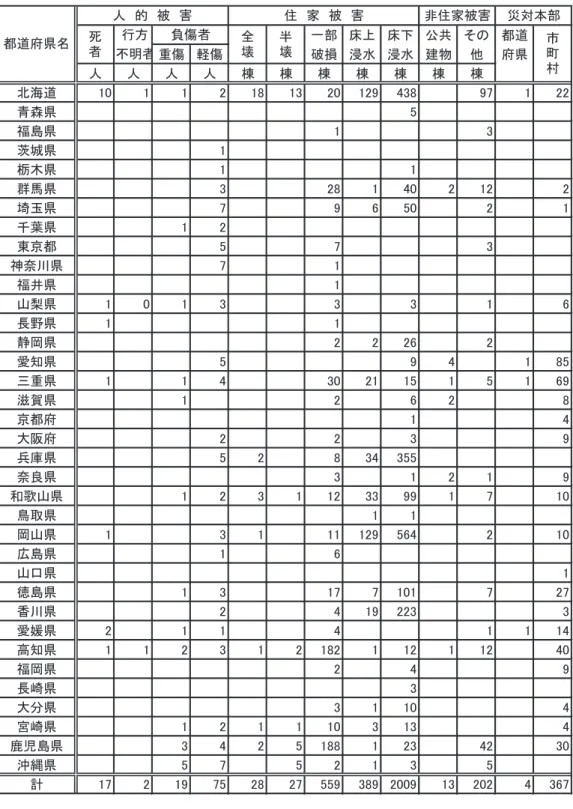
被害は表1に示すように,死者・行方不明者17人,重 軽傷者94人に達し,家屋の全半壊は55棟,床上浸水は 389棟であった.特に,北海道での被害が大きかった.
以下に北海道の日高・十勝地方を中心にした災害の特徴 について概要を述べる.
2. 1 豪雨による土砂災害の発生と多量の流木の流出 日高地方は台風10号の接近により,9日3時〜5時,
13時〜16時および21時〜翌日の1時に掛けて大雨が
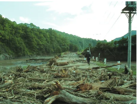
もたらされた(図1,口絵2参照).特に,第3波目の 大雨は平取町の旭で最大60分雨量91mmを記録し,近 年にない大洪水が発生した.この時,町村役場や道路等 の管理事務所が位置する海岸沿いでは強い雨は峠を越し ていた.沙流川や厚別川の山間地域では第1波および第 2波の大雨により,表層土壌は相当湿潤な状態に有った と推測される.そこに記録的な豪雨がもたらされ,流域 に保水しきれない大部分の雨水が短時間の内に河川に流 出したと推測される.また,各地で土砂崩壊や土石流が 発生し,多量の土砂と流木が生産された.それらは河川 に流出し,護岸の浸食,川床上昇,流木による橋梁の破 壊,橋上流での洪水位の堰上げ等を引き起こし,著しい 洪水被害を発生させた.沙流川の二風谷ダムではおびた だしい流木が流れ込み,流木の処理に多大な労力等を費 やした(口絵10参照).その事が幸いして,下流域では 流木による橋梁・護岸等の被害は比較的少なかった.一 方,上流にダムの無い厚別川では流れ出た多量な流木に より,橋梁や護岸が大きな被害を受けた(写真1参照).
2. 2 車両等の流失・落下
北海道の日高・十勝地方では豪雨災害により,11名 の死者・行方不明者が発生した.その内,10名は車の 流失・落下に伴うものであった.日高地方の新冠町では 国道の道路規制により,迂回路を取ったワゴン車が道道 の厚別川に架かる赤無橋付近で浸水により立ち往生した
(写真2参照).携帯電話で消防署に救助を求め,助けを 待つ内にそのワゴン車は5人を載せたまま洪水に流され た.5人の内,2人は救助されたが,3人が行方不明と なった.ワゴン車の他に一家3人が乗った乗用車が浸水 し,立ち往生したが,浸水がひどくなり危険を感じたの で車を放置し,膝上の浸水深の中を避難し,難を逃れて いた.また,十勝地方の上士幌町では居辺川に架かる居 辺橋への取り付け道路が洪水により陥没し,そこに通り がかったワゴン車とトラックが転落する事故が発生した
(写真3参照).このため,ワゴン車に乗っていた5人が 死亡した.これらは深夜の非常時の道路パトロールのあ り方や河川管理者と道路管理者間の相互の情報伝達や河 川情報の共有等による早期の交通規制について改めて問 題提起をした.
them by mobile phone and waited in what was a dangerous area. The water continued to rise and the van was washed away by the flood before the rescue team arrived. Three people disappeared, although two were rescued. In Kamishihoro Town, the Tokachi District, a road leading to a bridge had sunk due to the severe flooding. Another van, with five passengers, plunged into a hole where the road had caved in, undermined by the floodwater, and five people were washed away into the river. Many people did not know about the changes in the road conditions along their intended route during the severe flooding.
(3) Some damaged areas were cut off due to the severe flood, since the emergency administrative radio and isolation prevention radio did not function. The local disaster management headquarters found out about the distress in these areas only very late. Next morning, the prefectural police helicopter carried out reconnaissance to assess the damage. People were discovered trapped on roofs, waiting to be rescued. The reconnaissance mission was rapidly changed to a rescue mission. This shows the need to secure a means of contact during local emergencies and the importance of having a suitable rescue system.
表1 2003年(平成15年)8月台風10号の主な被害状況 Table 1 Statistics on the damage by Typhoon No. 10 on Aug. 8-10, 2003.
図1 2003年(平成15年)8月8−10日に掛けての台風10号の影響による北海道日高地方の雨量分布. 数字は8月 7日18時から10日4時の間の総雨量(mm),( )内数値は最大時間雨量
Fig. 1 Distribution of rainfall caused by Typhoon No. 10 on Aug. 8-10, 2003. Numbers are the total rainfall amount from 18:00 Aug. 7 to 4:00 Aug. 10 and the numbers in parenthesis are maximum hourly rainfall amount.
写真1 厚別川の比宇川合流点付近の道道路比宇厚賀停車場線における洪水後の流木の散乱状況.北海道庁提供_台 風被害状況資料/台風10号日高支庁管内の被害写真(URL:www.pref.hokkaido.jp/soumu/sm-bsbou/typhoon- 10/hidaka.htm)
Photo 1 Dispersion of driftwood over the hiukougateisyaba road of the Hokkaido Government after the flood near the confluence of the Hiu and Appetsu Rivers (courtesy of the Hokkaido Government, URL:www.pref.hokkaido.jp/soumu/sm- bsbou/typhoon-10/hidaka.htm).
写真2 新冠町共栄地区の厚別川沿いの氾濫源の洪水被害状況.ここで,5人を乗せたワゴン車が洪水で流失し,2人 は救助されたが3人が亡くなった.北海道庁提供_台風被害状況資料/台風10号日高支庁管内の被害写真
(URL:www.pref.hokkaido.jp/soumu/sm-bsbou/typhoon-10/hidaka.htm)
Photo 2 Flood damage on the flood plain along the Appetsu River in Kyouei district of Niikappu Town. A van with five passengers was washed away by the flood. Two people were rescued but three were lost (courtesy of the Hokkaido Government, URL:www.pref.hokkaido.jp/soumu/sm-bsbou/typhoon-10/hidaka.htm).
写真3 上士幌町の居辺(おりべ)川に架かる居辺橋の左岸側道路の陥没状況,ここで,ワゴン車が転落し,乗って いた5名が川に流され死亡した.北海道庁提供_台風被害状況資料/台風10号十勝支庁管内の被害写真
(URL:www.pref.hokkaido.jp/soumu/sm-bsbou/typhoon-10/tokati.htm)
Photo 3 The fatal cave-in of the road leading to the Oribe Bridge over the Oribe River in Kamishihoro Town. A van carrying five people plunged into a hole in the road. They were washed away by flood (courtesy of the Hokkaido Government, URL:www.pref.hokkaido.jp/soumu/sm-bsbou/typhoon-10/tokati.htm).
2. 3 被災地の孤立
防災行政無線や孤立化防止無線が十分に機能しなかっ たため,洪水により幾つもの被災地区が孤立状態に陥っ た.そのため,新冠町,門別町などの町村では孤立した 地域の被災状況を早期に把握できなかった.翌朝,被害 状況の偵察に来た北海道警察のヘリコプターが孤立した 屋根の上で救助を待っている人達を発見し,急遽偵察を 救助に切り替え,20数人の住民を救助した(口絵13参 照).門別町豊田地区では10日5時半頃,傾きかけてい る家の屋根から一家7名が上述のヘリにより危ないとこ ろを救助された.このことは孤立した地域の非常時の連 絡手段の確保と臨機応変な救助体制の必要性を示した.
3. 今後の対策
日高地方の災害では上述したように,山間地域の雨量,
河川の洪水や道路状況等の情報共有,氾濫時の車の走行,
緊急時の孤立地域の被災状況の早期把握等の問題が浮き 彫りになり,以下の対策が検討された.
(1)孤立した集落の被災状況を早期に把握するための緊 急時の情報伝達手段の確保・充実.
(2)道道の事前交通規制区域の強化.
(3)道路管理者による水位など河川情報の活用.
(4)河川上流地域の水位雨量観測施設の増設.
(5)関係機関との河川および道路関連情報の共有.
(6)緊急時の道路,河川等のパトロール体制の強化.
(7)流木により多くの橋が壊されたり,膨大な量の流木 の処理に苦慮したことから森林保全および流木流出 防止対策が必要.
(8)総合技術職の育成:道路と河川双方の知識と経験を 備えた職員など.
(原稿受理:2005年9月10日)