Abstract : The 5th International Symposium on Terrestrial Environmental Changes in East
Eurasia and Aduacent Areas : The daybreak of Paleoenvironmental dynamics
year 2006‑01‑01
URL http://hdl.handle.net/2297/3395
CONTENTS
- Abstracts are placed in alphabetical order with family name of the first author – [ORAL PRESENTATION]
SeungSoo Chun 8
Monsoonal sedimentation on an open-coast macrotidal flat, southwestern Korea: summer tidal flat - winter shoreface
Zhongli Ding 10
Long-term trend of the East-Asian monsoon evolution and possible forcing mechanisms
Seizo Fujikawa 11
Mechanisms of low temperature adaptation in trees
Keisuke Fukushi, Hiroto Fukumoto, Takashi Munemoto, Takahiro Nagata,
Kenji Kashiwaya 12
Carbonate mineralogy in sediment from Lake Hovsgol and its implications for environmental and geochemical changes of lake water
Noriko Hasebe, Kenji Kashiwaya 14
Overview of Geochronological Research on Lake sediments
Kazumi Ito, Noriko Hasebe, Yoshihiro Ganzawa, Kenji Kashiwaya 16 Luminescence dating of fine grained sediments from Lake Baikal ; an attempt
Kaoru Kashima 18
Holocene Lake Level Fluctuations at Inland Saline Lakes in the Semi-arid Regions, and Their Relationships to Holocene Climatic Changes
Kenji Kashiwaya, Shinya Ochiai, Gen Sumino, Takuya Tsukamoto,
Anna Szyniszewska, Hideo Sakai, Takayoshi Kawai 19
Environmental changes in lake-catchment systems inferred from Baikal district Fumitaka Katamura, Masami Fukuda, Nikolai P. Bosikov, Roman V. Desyatkin,
Toshio Nakamura, Jun Moriizumi 20
Thermokarst formation and vegetation history inferred from a palynological
study in central Yakutia, eastern Siberia
Vadim A. Kravchinsky, Valentina S. Zykina, Vladimir S. Zykin 24 Magnetic indicators of global paleoclimate cycles in Siberian Pleistocene loess- paleosol sequences and Lake Baikal sediments
Sergey Krivonogov 26
Dammed lakes in North Asian mountains as archives of glacial and post-glacial events. An overview of the problem.
Kuzmin M.I., Yarmolyuk V.V., Bezrukova E.V., Khomutova M. Yu 28 Global and regional natural catastrophs in the central Asia and their reflection in sedimentary records from lake Baikal and lake Hovsgol
Syukuro Manabe 30
Influence of Tibetan Plateau upon the Arid Climate of Eurasia
Eiji Matsumoto 31
Temperature variation since the LGM with carbonates in Erhel Lake sediment, Mongolia
Genki I. Matsumoto, Hitomi Suzuki, Misa Sato, Misako Makishima, Yoko Anzai,
Hitomi Chigasaki, Yukinori Tani, Yoshitaka Hase, Tetsuo Takemura, Takayoshi Kawai 32 Paleoenvironmental changes in the northeast Eurasia during the last 1 million years inferred from organic components in HDP-04 sediment core from Lake Hovsgol, Mongolia
Yury Mikishin, Irena Gvozdeva 34
Natural changes in the north-eastern Sakhalin in Holocene
Toshio Nakamura, Takahiro Watanabe, Fumiko Watanabe Nara, Kazuho Horiuchi, Ryoko Senda, Takefumi Oda, Mitsugu Nishimura, Genki Inoue Matsumoto,
Takayoshi Kawai 37
Summary of AMS
14C ages of cored sediments from Lake Baikal and Lake Hovsgol measured at Nagoya University
Fumiko Watanabe Nara, Takahiro Watanabe, Kazuho Horiuchi, Akio Imai,
Haruhiko Seyama, Toshio Nakamura, Takayoshi Kawai 38
Change of sulfur accumulation in Lake Hovsgol sediments (cores X104 and X106) during the last 23,000 years
Narantsetseg Ts., Tomurhuu D., Oyunchimeg Ts., Kalugin I. A., Daryin A. B 40 Correlation of the composition and geochemical features of bottom and runoff sediments of the lake Hovsgol, Mongolia: it’s implication to the paleoclimate changes
Hedi Oberhensli and the CONTINENT team 42
Lake Baikal a marvelous climate archive: A few highlights of the European Project CONTINENT
Shinya Ochiai, Kenji Kashiwaya 43
Late Cenozoic limno- and hydro-climatic changes printed in Lake Baikal
Sediment
Orkhonselenge. A, Tanaka. Y, Kashiwaya. K., Kim, Y. K 44 Landform evolution and surface erosion in pond catchment system, South Korea
Alexander A. Prokopenko, Galina K. Khursevich, Elena V. Bezrukova,
Mikhail I. Kuzmin, Svetlana A. Fedenya, Nataliya V. Kulagina, Polina P. Letunova,
Anna A. Abzaeva 45
Paleoenvironmental proxy records from Lake Hovsgol, Mongolia: new data on the Holocene climate in Lake Baikal watershed
Boris F. Pshenichnikov 46
Role of Relict and Modern Pedogenic Processes in Formation of Soils in the Maritime and Insular Zone of the Sea of Japan (in the Southern Russian Far East)
Ji Shen, Sumin Wang, Zhisheng An, Xiaoke Qiang, Haifeng Xiao, Xiayun Xiao 49 Environment evolution and human activity inferred from lacustrine record, southwest China
Koji Shichi, Yoshitaka Hase, Hikaru Takahara, Takahiro Watanabe,
Toshio Nakamura, Yukinori Tani, Takayoshi Kawai 51
A high resolution vegetation record in the southern region of Lake Baikal during the last 28,000 years
Yukiya Tanaka,Yukinori Matsukura 53
Sheetflood deposits on dissected pediment of Western Korean Peninsula: as an indicator of past dry climate
P. Tarasov, E. Bezrukova, E. Karabanov, T. Nakagawa, M. Wagner, N. Kulagina,
P. Letunova, A. Abzaeva, W. Granoszewski, F. Riedel 55 Late glacial and Holocene climate dynamics in lake Baikal region, Russia:
pollen-derived estimates
Dong Yoon Yang, Ju-Yong Kim, Wook-Hyun Nahm, Eunyoung Ryu, Sangheon Yi 57 Holocene wetland environmental change based on organic matters and metal contents from the Cheollipo coast, Korea
Sangheon Yi, Dong-Yoon Yang, Ju-Yong Kim 58
Postglacial vegetation history in response to climate changes in Korea
Zhou Weijian 60
[POSTER PRESENTATION]
Manabu Abe, Tetsuzo Yasunari, Akio Kitoh 62
Change of vegetation in Asia associated with uplift of the Tibetan Plateau
A.A. Abzaeva, E.V. Bezrukova, S.K. Krivonogov 63
New detailed records of changes in vegetation and climate in the late glaical and Holocene, northern shore of lake Baikal
V.S.Antipin, B.V.Tomilov 65
Chemical composition and sources of substance involved in formation of sands in different petrographic provinces of Pre-Baikal area
V.B.Bazarova, M.A.Klimin 67
Late Pleistocene and Holocene climatic and environmental changes in Lower Amur River basin
Victoria J. Bonvento, Alexander A. Prokopenko, Galina K. Khursevich, Mikhail I. Kuzmin 69 Oxygen Stable Isotope Proxy record for hydrologic change in Lake Hovsgol, NW Mongolia
Peng Cheng, Wei-jian Zhou, Hua-gui Yu 70
Pyrolysis-combustion
14C dating of total soil organic matter (SOM)in loess- paleosoil
Yoshitaka Hase, Genki I. Matsumoto, Hajime Umeda, Kosuke Yonemura,
Yukinori Tani, Kenju Hiraki, Dondovyn Tomurhuu, Tserentsegmid Oyunchimeg,
Takayoshi Kawai 71
Study of correlation based on pollen analysis and organic composition of the bottom sediments in Lake Hovsgol, Mongolia
Ryoma Hayashi, Hikaru Takahara, Tohru Danhara, Shusaku Yoshikawa, Yoshio Inouchi 73 Vegetation response to climate changes since the last interglacial based on pollen data of the Kamiyoshi Basin and Lake Biwa sediments
Kentaro Ito, Noriko Hasebe 75
Observation of spontaneous fission-track density using stepwise etching E. Karabanov, V. Bychinskyi, A. Gvozdkov, J. Osukhovskaya, M. Kuzmin,
D. Williams, E. Solotchina, E. Bezrukova, G. Khursevich, P. Tarasov, P. Letunova 77 Environmental changes of the Lake Baikal and Lake Baikal watershed during the Last Glacial and the Holocene based on multiproxy records.
Nagayoshi Katsuta, Masao Takano, Shin-ichi Kawakami, Shoji Togami,
Hitoshi Fukusawa, Mineo Kumazawa, Yoshinori Yasuda. 80
Advanced micro-XRF method to separate sedimentary rhythms and event
layers in sediments: climate system transition from glacial to interglacial state
around the beginning of the last termination
In Seon Kim, Jong Hyun Nam, Xiaobing Liang, Tae Seok Ahn 81 Vertical distribution of sulfate reducing bacteria of Desulfovibrionaceae in sediment of Lakes Sihwa and Soyang, Korea
Jeong Chan Kim, Ju-Yong Kim, Sangheon Yi, Wook-Hyun Nahm, Dong Yoon Yang, Keun-Chang Oh, Sei-Sun Hong, Eunyoung Ryu, Jin -Young Lee, Jin-Kwan Kim,
Hyun-Soo Yun 82
Late Quaternary Stratigraphy of Fluvial Sediments in the Hanam area, Korea
Song-hyun Kim, Yukia Tanaka 83
Palaeoflood and river terrace deposits of Hongcheon river basin, Korea Tamai Matsuoka, Kenji Kashiwaya, Wook-Hyun Nahm, Dong-Yoon Yang,
Aleksandr Orkhonselenge, Yukiya Tanaka 84
Hydro-geomorphological changes in pond-catchment systems in Japan and Korea
Maki Morimoto, Osamu Abe, Takayoshi Kawai 85
KHF
2-CoF
3method for determining oxygen isotopes of biogenic silica in lacustrine sediments
Takuma Murakami, Nobuki Takamatsu, Koshi Yamamoto, Genki I. Matsumoto,
Kazuho Horiuchi, Takefumi Oda, Takayoshi Kawai 86
Inorganic elements in carbonates of Lake Hovsgol sediment
Park, Chung-Sun, Yoon, Soon-Ock, Hwang, Sang-Ill 88 The Weathering Characteristics and Origin of Loess-Paleosol Sequence at Bongdong Section, South Korea
Takayuki Sakai, Koji Minoura 89
Siberian paleoclimate changes: evidence from Lake Hovsgol
S. Song, W. Zhou 90
Response to environmental conditions for coral δ
18O of Porites lutea from Shalao, Hainan Island, China
Song Yougui, Fang Xiaomin, Naoto Ishikawa, Masayuki Torii, An Zhisheng 91 Rock magnetic evidences of middle Pleistocene Climate Transition recorded in Chinese Loess-paleosol sequence
Yukinori Tani, Genki I. Matsumoto, Mitsuyuki Soma, Yuko Soma,
Shinya Hashimoto, Takayoshi Kawai 92
Y. Wada, N. Katsuta, M. Takano, M. Kunugi, T. Kawai 96 Preliminary report on elemental and density profiles of Lake Hovsgol sediment core (HDP04) during the last 1 Myr in Mongol with micro-XRF and TXR analysis
Takahiro Watanabe, Toshio Nakamura, Mitsugu Nishimura, Takayoshi Kawai 97 Environmental changes in Siberian and Tibetan lakes during the last 25,000 yr inferred from radiocarbon and stable carbon isotopes
Kyung Sik Woo, Kyoung Nam Jo, Jeong Chan Kim, Dong-Yoon Yang 98 Kinetic Fractionation Processse in the Stalagmites of Limestone Caves in Korea: Implications for Paleoclimatic Investigation
Yanbei Zhu, Hongwei Liu, Eiji Fujimori, Tomonari Umemura, Hiroki Haraguchi 99 Biogenic Silica and Multielement Record of Paleoclimate Changes in Lake Baikal Drill Core BDP-99
Yu Liu 101
Dendroclimatology in North China
ORAL PRESENTATION
ABSTRACTS
Monsoonal sedimentation on an open-coast macrotidal flat, southwestern Korea:
summer tidal flat - winter shoreface
SeungSoo Chun
Faculty of Earth Systems and Environmental Sciences, Chonnam National University, Gwangju 500-757, Korea (E-mail: [email protected])
Introduction
Most works in the tidal-flat sedimentology have focused on the estuarine- and embayment- type environments during the past few decades. On the contrary, open-coast tidal flats have been less studied despite its common occurrence in modern environments. In temperate regions, wave conditions may be of much greater significance than tidal-current magnitude, particularly in monsoon climate regions. The Baeksu/Doowoori coast, locating in the southwestern coast of Korea, can be representative of typical open, non-barred macro-tidal flat in temperate region. It is strongly influenced by monsoon wind waves in the winter season. This paper aims to reveal the seasonal variation of sedimentation and surface facies, controlled by tide and wave effects in the open-coast macro-intertidal flat setting.
Environmental setting
The flat is 16-20 km wide and faces directly onto Yellow Sea. It is bordered on its landward side by rocky coastal cliffs or by artificial dykes that have been constructed to reclaim tidal marshes in a former embayment. These dykes inhibit the introduction of terrigenous sediment from landward sources. Tides are semi-diurnal (diurnal inequality of about 1 m) with a mean spring range of 5.4 m. The maximum current velocity is ca. 60 cm/sec during spring tides and ca. 40 cm/sec during neap tides, but speeds depend strongly on the wind magnitude and direction. Storms (defined as times with wind speeds >13.9 m/s) display a pronounced seasonality, occurring less than 2-3 days/month during the summer, but more than 10 days/month during the winter, when waves with heights of 1.5-2.0 m are common. At this time, intertidal swash bars, 100 to 300 m wide and 0.5 to 1 m high, migrate landward at rates of ca. 75 m/yr.
Seasonal sedimentation
During the summer, tidal-flat sedimentation is dominated by tidal currents with minor wave action because of weak winds. Furthermore, maximum solar insolation facilitates rapid drying and consolidation of fine-grained sediments. Bioturbation is minimal because of rapid sedimentation and soft substrate. Heterolithic stratification (including lenticular and tidal bedding) and homogeneous mud are the dominant deposit types. During the autumn, the summer mud deposits experience erosion due to increasingly strong onshore winds and waves, until only small mud patches and mud pebbles remain. By the end of the fall season, most of the summer mud has been eroded, leaving only small, isolated mud patches. Mud balls produced by the erosion of the summer mud are abundant at this time of the year. The concentration of ebb runoff between the mud patches produces small, ephemeral tidal creeks.
All of the remainder of the tidal-flat surface is covered by fine to very fine sand.
In winter, storm waves occur frequently (ca 10 days a month) and dominate sedimentation
in the intertidal zone, producing extensive wave-generated parallel lamination and short-
wavelength (0.3-2 m) hummocky cross-stratification (HCS) which is notable for its shorter
wavelength compared to those reported from offshore and shoreface deposits. Bioturbation is
extremely rare, except in the uppermost tidal flat where the wave energy is least. Surface
sediments consist dominantly of well sorted fine to very fine sand with minor silt. Mud
pebbles are the only remnants of the summer mud layer. The preserved sedimentary
structures closely resemble shoreface deposits. The prevalence of strong onshore winds decreases in spring, allowing longer and more frequent intervals of calm weather, during which time muddy sediments are deposited by tidal processes. Over the long term, winter storm waves dominate sedimentation and the preserved deposits consist of amalgamated storm beds that resemble those generally associated with shorefaces.
Conclusions
The open-coast tidal flat reveals that it behaves like a typical sheltered tidal flat during the summer, accumulating muddy heterolithic deposits because of the subdued wave energy and high solar insolation; and during the winter and spring, when intense storms are frequent, the tidal flat behaves like a beach and shoreface, accumulating graded storm beds that contain parallel lamination, hummocky cross stratification; and wave ripples. The preservation potential of the muddy heterolithic facies is very low as a result of intense erosion by storms during the fall and winter. As a result, the preserved deposits are dominated by amalgamated storm beds and resemble shoreface successions. This raises the question of whether many ancient "shorefaces" are, in fact, open-coast tidal flats.
Long-term trend of the East-Asian monsoon evolution and possible forcing mechanisms
Zhongli Ding Institute of Geology and Geophysics, CAS, Beijing 100029
Several groups in China have recently compiled the paleo-data on environmental changes during the Cenozoic. All their results indicate a major shift of spatial climate conditions over China continent at the latest Oligocene or the Oligocene/Miocene boundary, manifested by the disappearance of a broad, longitudinal arid belt at mid-latitudes and appearance of a latitudinal humid belt in the east and middle parts of China. This shift is interpreted as a profound re-organization of atmospheric circulation pattern, specifically a replacement of a planetary circulation pattern by a monsoon circulation system like today
ユs. This thus raises the question: how has the East-Asian monsoon evolved during the Neogene? In recent years, numeral long paleo-records have been retrieved in China by studies of eolian loess-red clay sequences and lacustrine deposits. Integration of these records suggests an overall trend of the summer monsoon towards an oscillatory decrease in strength. For example, most of the Miocene paleosols in the Qin-an red clay section contain abundant clay coatings formed under relatively humid climatic conditions, whereas the Pleistocene paleosols and the Holocene soil at Qin-an were developed under dry conditions without any clay coating; and the early Miocene paleosols have much more clay coatings than the late Miocene paleosols.
This pedogenetical observation suggests a stronger summer monsoon in the early Miocene than in the late Miocene. Studies of fossil snail assemblages in the Xifeng red clay section show that during the latest Miocene and Pliocene, climate conditions in the middle Loess Plateau stepwisely became drier, probably resulting mainly from a stepwise weakening summer monsoon. The Jingbian loess-red clay section, situated in the northernmost part of the Loess Plateau, covers the latest Pliocene and the entire Pleistocene. Grain size analyses of the Jingbian sequence demonstrate a stepwise increase in sand component (>63 mm%) of the eolian sediments, being from almost 0% in the latest Pliocene to about 80% in the late Pleistocene. As variations in the sand-sized particle fraction within loess near the desert margin may be primarily controlled by the migration of the southern desert margin where sand grains move mainly in saltation mode near the ground surface, increase in this fraction can be linked to southward expansion of the deserts, in turn suggesting southward retreat of monsoon rain-belt. We preliminarily propose that the oscillatory weakening trend of the East- Asian summer monsoon could have been forced by the increase in global ice-volume during the Neogene.
Mechanisms of low temperature adaptation in trees
Seizo Fujikawa
Laboratory of Woody Plant Biology, Division of Environmental Resources, Graduate School of Agriculture, Hokkaido University, Sapporo, 060-8589 Japan
Tel; 011-706-2511, Fax; 011-736-1791, E-mail; [email protected]
Among all creatures, trees have hugest body, so that unmovable trees are directly exposed to a variety of environmental stresses. Low temperature is one of most serious environmental stresses for such trees. In cold areas, trees are exposed to cold of approximately -70C during winter, but trees can adapt such an extremely low temperature condition and continue to grow for many years.
In order to adapt winter cold, trees are developing complicated adaptation mechanisms.
Due to such diverse adaptation mechanisms to cold temperature, trees are different with many other herbaceous plants which adapt to sub-freezing temperature essentially by single method, extracellular freezing. The phloem, cambium and leaf tissue cells in trees adapt to sub-zero temperature by extracellular freezing, the xylem tissue cells in trees adapt by deep- supercooling, and winter buds in some trees adapt by extra-organ freezing.
Among these tree tissues with different freezing adaptation mechanisms, freezing resistance of xylem parenchyma cells, that adapt by deep supercooling, are weakest. By adaptation with deep supercooling, water in cells can keep liquid state. During supercooling such cells can survive, but supercooling of water has physical limit and below the limiting temperature lethal intracellular freezing occurs and damage of such cells leads to death of entire trees. Thus, the temperature limit of deep supercooling is a key factor for freezing resistance of trees. The temperature limit of supercooling changes depending upon change of environmental temperatures. The supercooling capability of xylem parenchyma cells in trees increases gradually in trees growing in tropical toward cold areas. The supercooling capability also changes seasonally with highest capability in winter and lowest capability during summer. Thus, trees are adapting low temperatures by increase supercooling capability in xylem parenchyma cells under low temperature condition.
The present study will show our recent approaches to understand mechanisms of deep supercooling in xylem parenchyma cells of trees, in regard to gene expression, accumulation of proteins, accumulation of soluble sugars, and presence of anti-ice nucleation substances, in association with increased supercooling capability.
Keywords: Tree, Low temperature, Extracellular freezing, Deep supercooling, cold-
induced genes
Carbonate mineralogy in sediment from Lake Hovsgol and its implications for environmental and geochemical changes of lake water
Keisuke Fukushi
1, Hiroto Fukumoto
2, Takashi Munemoto
2, Takahiro Nagata
2and Kenji Kashiwaya
11
Institute of Nature and Environmental Technology, Kanazawa University, Kanazawa, Ishikawa 920- 1192, JAPAN
2
Department of Earth Sciences, Faculty of Science, Kanazawa University, Kanazawa, Ishikawa 920- 1192, JAPAN
+81-76-264-6520, [email protected]
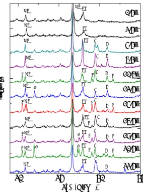
Carbonate minerals are one of the important components of sediments. Chemistry of the water is controlled by the reactions of these minerals if these minerals are allowed to form during the sedimentation processes. On the other hand, the mineralogy of the carbonate is determined by the water quality and temperature in lake water. Lake Hovsgol is a semi- closed lake located in the inside of the continent. Because there are little human activities in the vicinity of the lake, it is expected to be sensitive to the environmental and geochemical changes. The one of characteristics of the sediments from Lake Hovsgol is that the sediments are mainly composed of carbonate minerals. Kashiwaya et al. (submitted) analyzed HDP04 core from Lake Hovsgol and showed that HCl soluble fraction which is attributable to carbonate minerals tends to increase at glacial periods [1]. This indicates that carbonate minerals are important indicator for environmental changes in Lake Hovsgol. In present study, we examined the detailed carbonate mineralogy of the sediment core (HDP04) with depth to evaluate the changes of past environment and geochemistry of lake.
Figure shows the XRD patterns of sediment core samples with depth up to 22.5m of which age is correspond to 356kyr B.P. (Kashiwaya et
al., submitted). XRD patterns of core sediments showed that the common mineral phases are quartz, feldspar and small amounts of clays minerals. In addition, XRD patterns of less than 4.5m depth showed the several peaks assigned to various carbonate minerals. The common carbonate phases are calcite (CaCO
3) and dolomite (MgCa(CO
3)
2), but the peaks attributed to the monohydrocalcite (MHC:
CaCO
3.H
2O) are also identified in some samples. MHC is rare mineral in geological environment, because the mineral can only form and be preserved in anomalous geochemical conditions [2]. MHC is much more soluble than calcite and metastable with respect to calcite [3]. The formation of MHC would require the high concentration of dissolved constituents in lake water. The preservation of HMC in geological setting would require low temperature condition, because the transformation rates of metastable phases to crystalline phases are commonly accelerated with
20 25 30 35
2°θ(CuKα)
Intensity
0.5m 2.5m 4.5m 6.3m 10.6m 12.5m 14.5m 16.5m 18.5m 20.5m 22.5m
Qz Qz
Qz
Qz
Qz
Qz Qz
Qz
Qz
Qz
Qz
Qz
Fd
H
H
H
H
Fd Fd
Fd
Fd
Fd
Fd
Fd
Fd
Fd D D
D
D
D
D
D
D
D H
H
H H
H C
C
C
C C
C
C
C
C H H H H
?
? ?
?
Figure XRD patterns of core sediment with depth.
Qz: quartz, Fd: feldspar (plagioclase), C: calcite, D:
dolomite, H: monohydrocalcite, ?: unidentified phases.
temperature. From these unique geochemical characteristics of HMC, the occurrence of HMC would serve as detailed records of past environment and geochemistry of lake.
Although it is difficult to estimate the water temperature during the HMC formation because the formation of HMC is little dependent on temperature [2, 3], it is possible to estimate the water quality especially pH during the formation by using the solubility data for HMC [3]. The pH of closed lake water with carbonate minerals is determined by chemical equilibria among water, carbonate mineral and atmospheric carbon dioxide [4]. Assuming the present lake water is equilibrium with calcite and atmospheric carbon dioxide of which partial pressure is 380 ppmv, the pH of solution is calculated to be 8.2 for temperature of 0 to 25 ºC. This pH is quite similar to the observed pH (8.1) measured at center of the lake [5]. On the other hand, the pH of solution which is equilibrium with HMC and past atmospheric carbon dioxide (200 to 300 ppmv for object period [6]) is calculated to be 8.8 -8.9 for the same temperature range. Even slight changes of pH can strongly influence on the ecosystem and geochemistry in aquatic environment [4]. The estimated difference of pH form carbonate mineralogy indicates that ecosystem and geochemistry of the past lake environment was significantly different from the present environment.
References:
[1] Kashiwaya et al., submitted
[2] Taylor, American Mineralogist, vol. 60, pp. 690-697, 1975
[3] Kralj and Brecevic, Colloids and Surfaces A, vol. 96, pp. 287-293, 1995
[4] Stumm and Morgan, Aquatic Chemistry (3rd ed.). New York: Wiley-Interscience, 1996 [5] Hayakawa et al., Limnology, vol. 4, pp. 25-33, 2003
[6] Petit et al., Nature, vol. 399, pp. 429-436, 1999
Keywords: Hovsgol, HDP04, carbonate minerals, monohydrocalcite, pH
Overview of Geochronological Research on Lake sediments
Noriko Hasebe and Kenji Kashiwaya
Institute of Nature and Environmental Technology, Kanazawa University, Kanazawa, 920-1192 Japan Tel +81-76-264-6529: Fax +81-76-264-6545: e-mail [email protected]
Lake sediments yield records of information about past climatic and tectonic conditions with local to global scales depending on geomorphological circumstances of lakes where sediments were recovered. Sediment supply could be from catchement area where geology, topography, precipitation would be main factors to control some of sediments' characteristics.
Or, when erosion is minor in surrounding area, aerosol deposition would be dominant and provide global scale information. Dating of sediments is the first step to extract quantitative historical information from the record. Here we overview the recent topics and our attempts to obtain the radiometric ages from the lake sediments.
Luminescence dating
Luminescece dating of lake sediments has been applied to a particular mineral with grain sizes grater than ~10 (in many case >100) mm extracted from interbedded tuff layers (Shane et al, 2002) or sandy layers (Argyilan et al., 2005: Rogalev et al., 1998). Recent advances in luminescence dating allow analyses of fine-grained samples without mineral separation (Banerjee et al., 2001) and successfully applied to ocean core sediments (Berger, 2006).
According to our attempt to apply the methodology to sediments from lake Baikal, the infra- red stimulated luminescence shows no linear relationship against give dose and is difficult to estimate a reliable accumulated dose. On the other hand, the red thermoluminescence gives a more promising relationship between signal intensity and given dose, and is applied to deliver the accumulated dose (Ito et al., presentation during this conference).
Fission-track dating
Quaternary tephra layers in lake sediments are good time-makers. Their ages could be determined by several radiometric dating methods, one of which is the fission track (FT) chronometry using volcanic glasses. The FT glass ages were often younger than expected ages due to a partial annealing of track at ambient temperatures, therefore, several calibration procedures were proposed. However, the FT glass dating becomes less popular because these procedures need time consuming experiments. To avoid the calibration, a new protocol to estimate the glass FT density is proposed (Ito and Hasebe, presentation during this conference)
LA-ICP-MS analyses
The LA-ICP-MS is widely accepted as a rapid method to determine chemical composition of geological material at the micro-scale and applied to geochronology. For both luminescence and FT datings, the new methodology to determine the radioisotope composition is proposed and applied.
References:
Argyilan, E. P., Forman, S. L., Johnston, J. W. & Wilcox, D. A. 2005. Optically stimulated luminescence dating of late Holocene raised strandplain sequences adjacent to Lakes Michigan and Superior, Upper Peninsula, Michigan, USA. Quat. Res., 63, 122-135.
Banerjee, D., Murray, A. S., Bøtter-Jensen, L. & Lang, A. 2001. Equivalent dose estimation using a single aliquot of polymineral fine grains. Rad. Meas., 33, 73-94.
Berger, G. W. 2006. Trans-arctic-ocean tests of fine-silt luminescence sediment dating
provide a basis for an additional geochronometer for this region. Quat. Sci. Rev., 25, 2529- 2551.
Rogalev, B., Chernov, V., Korjonen, K. & Jungner, H. 1998. Simultaneous thermoluminescence and optically stimulated luminescence dating of late Pleistocene sediments from Lake Baikal. Rad. Meas., 29, 441-444.
Shane, P., Lian, O. B., Augustinus, P., Chisari, R. & Heijni, H. 2002. Tephrostratigraphy and geochronology of a ca. 120 ka terrestrial record at Lake Poukawa, North Island, New Zealand. Global Planet. Change, 33, 221-242.
Keywords: Geochronology, Luminescence dating, Fission track dating, LA-ICP-MS
Luminescence dating of fine grained sediments from Lake Baikal ; an attempt
KAZUMI ITO
1, NORIKO HASEBE
2, YOSHIHIRO GANZAWA
3and KENJI KASHIWAYA
21
Graduate School of Natural Science and Technology, Kanazawa University, kakuma, kanazawa 920- 1192, Japan
2
Institute of Nature and Environmental Technology, Kanazawa University, Kakuma, Knazawa 920- 1192, Japan
3
Institute of Earth Science, Hokkaido University of Education, Hachiman 1-2, Hakodate 040-8567, Japan
TEL : +81-76-264-6513 FAX : +81-76-264-6545 E-mail : [email protected] 1. Introduction
Lake sediments yield continental records of past environmental fluctuation and dating is important to extract quantitative information from those sediments. Luminescence dating is applicable to middle to late Quaternary samples, and basically applied to a particular mineral such as quartz, feldspar and so on. However, fine grained samples with limited quantities are difficult to apply mineral separation. Therefore, this study examines luminescence characteristics of polymineral lake sediments.
2. Purpose of this study
The best experimental condition is sought for red thermoluminescence (RTL) methods. The relationship between given dose and luminescence intensity is examined to see the effect of grain size variation and organic matter incorporation. To understand what resets luminescence ages, samples are exposed to artificial lights to see a decrease of luminescence signal. Also, to investigate the measurable age range, a saturated dose is estimated. Signal alteration through core recovery from the lake bottom and subsequent sample divide in a laboratory is also investigated. Finally, equivalent dose (D
e) is measured.
3. Sites and Samples
Sediment samples were collected from the deepest part of Central Basin (M-14) and Academician Ridge (VER98 st.5) of Lake Baikal. Detailed descriptions can be found in Sasaki (2002MS) and Nakagawa (2000MS). Three analyzed samples (2C-32, 2D-06 and 4A- 18) from VER98 were obtained at a depth of 268, 308 and 708 cm from the lake bottom and expected age based on oxygen isotope ratio stage are 110, 120 and 200 ka, respectively.
4. Experimental method
The M-14 was divided into four aliquots according to grain sizes (in microns), that is, 6-11, 11-17, 17-32, 75-125. An aliquot without grain size separation called “all” was also analyzed.
A part of aliquots 11-17 and “all” was further treated using H
2O
2to remove organic matter.
No treatment was applied to the 2C-32, 2D-06 and 4A-18. The RTL was measured at Hokkaido University of Education. The M-14 was used for a dose recovery test (Tsukamoto, 2005), a breach test and a measurable age range test. 2C-32, 2D-06 and 4A-18 were used to estimate signal alteration through sampling and afterwards D
ewas measured.
5. Result and conclusion M-14
The RTL is mainly emitted at 150℃ and 250℃. A peak at 150℃ is attributed to the unstable
luminescence against heat. Signals, calculated by integration of luminescence intensities at
the temperature range of 240~260℃, show an excellent stable linear relationship against
given doses. However, artificial accumulated dose was overestimated and an excess dose is
about 25Gy at an average. Effects of grain size and organic matter on luminescence are
negligible. Bleach tests show that an intensity of RTL reduces down to 30% by the exposure to the sun light. To investigate the age limit applicable, doses up to 960Gy were irradiated.
Calibration curve is bent at ~700Gy, but is not saturated up to 960Gy.
2C-32, 2D-06 and 4A-18
For each sample, four to thirteen data were obtained along the traverse from the surface to center of a cubic sample. D
e, calculated by the RTL measurement after residual dose estimation is concordant regardless a distance from the sample surface. Therefore, average D
eand residual dose were calculated (table).
6. References
Sasaki Miki (2002MS): Recent Limno-geomorphological Environment in Baikal Region Inferred from Surficial Lake Sediments and Its Surrounding Environmental Information Hirofumi Nakagawa (2000MS): Climato-limnological signals found in physical properties and biogenic silica content of bottom sediments from Lake Baikal during the past several hundred thousand years
Tsukamoto (2005); Recent development in luminescence dating; on the extending the age range and the behavior of different OSL components from quartz, Jour. Geol. Soc. Japan, Vol. 111, No. 11, p. 643-653
Keywords: Luminescence Dating, Lake Baikal
Table Results of D
emeasurement
number of aliquots residual dose (Gy) D
e(Gy)
2C-32 4 18 78 ± 3.7
2D-06 4 22 69 ± 7.9
4A-18 13 36 112 ± 20
Holocene Lake Level Fluctuations at Inland Saline Lakes in the Semi-arid Regions, and Their Relationships to Holocene Climatic Changes
Kaoru KASHIMA
Maintaining the quality of natural resources in semi-arid regions became an important environmental issue of the 1990s. Has the quality changed as a result of human activities or as a result of natural environmental changes, such as climatic change? What were the timing, rate, and extent of environmental change, and how can we infer these aspects?
Inland lakes have been very important places for human beings since ancient days.
However long-term monitoring of their environment usually do not extend back more than a few centuries, and for many regions the historical record is much shorter.
The geological research project in Turkey and Syria, a multidisciplinary research program to investigate environmental history since Quaternary, has started in 1991 in conjunction with the archaeological excavation of Kaman-Kalehöyük by the Japanese Institute of Anatolian Archaeology, and the excavation of Tel Seker al-Aheimal by University of Tokyo.
We focused the high resolution environmental reconstruction from central Turkey to north Syria to discuss relationships between environmental changes and archaeological epochs. We took field surveys at inland lakes and marshes surrounding archaeological sites at Konya basin, Lake Tuz, Lake Ak, Lake Seyfe, Kayseri and Kaman Kalehöyük in central Turkey, and Lake Khatouniyeh in north east Syria.
Our drilling surveys presumed that there was a distinct local diversity of climatic change during the Holocene. A dry climate started about 11000 BC in corresponding to the global warming after the Younger Dryas. It was a wide climatic phenomenon because we observed it at all our survey points. The recover of humid environment during Neolithic occurred at first in Lake Khatouniyeh, north east Syria. The Holocene sedimentation of the lake began about 8500 BC, and it turned to be very humid environment at about 6700 BC. In contrast to it, dry environment continued in central Turkey during the Neolithic. The water levels increased again about 4500 BC when the global temperature turned to be stable in small lakes and marshes about 150-200 km east or north-east of Konya basin. However dry environment has continued in Konya basin and Lake Tuz in central or southern part of the Anatolian Plateau.
Keywords: human impact, environmental change, Quaternary, Holocene, semi-arid regions
Eenvironmental changes in lake-catchment systems inferred from Baikal district Kenji Kashiwaya
a, Shinya Ochiai
a, Gen Sumino
b, Takuya Tsukamoto
b,
Anna Szyniszewska
b, Hideo Sakai
c, Takayoshi Kawai
da
Institute of Nature and Environmental Technology, Kanazawa University, Kanazawa 920-1192, Japan
b
Department of Earth Sciences, Kanazawa University, Kanazawa 920-1192, Japan
c
Department of Earth Sciences, Toyama University, Toyama 930-8555, Japan,
d
Graduate school of Environmental Sciences, Nagoya University, Nagoya 350-0044, Japan
Phone & Fax; 81-76-264-6531, e-mail; [email protected]
The Lake Baikal district, in the middle latitudes, is highly sensitive to changes in solar insolation related to long-term climatic changes. This region is influenced not only by westerly circulation, but also by the East Asian monsoon. Its prevailing wind system is closely related to the proximity of the Himayalas and the Tibetan Plateau. These factors imply that direct solar insolation is crucial in this district, especially in the high plateaus of the middle-latitude zone. Lake Hovsgol in the Baikal Rift Zone is located on the high plateau of Mongolia and belongs to the Lake Baikal catchment. It is the second largest freshwater lake in East Asia and drains to Lake Baikal through a single outflow river at its south end, the Egiin, a tributary of the Selenga (the largest river in the catchment). The river mouth controls the lake water level. Lake Hovsgol is presumed to have been nearly a closed lake during glacials. The present elevation of the water surface (1650 m) is 1100 m higher than that of Lake Baikal. The water-surface and catchment areas are 2770 km
2and 4920 km
2, respectively, so the lake-catchment ratio is quite large. These factors imply that environmental conditions here are more sensitive to direct solar insolation, and that the lake sediments are directly and strongly influenced by environments in the surrounding catchments
In 2004, core HDP04, 81 meters long, was obtained at a water depth of 250 m from the central part of Lake Hovsgol (50° 57′ 19″ N , 100° 21′ 32″ E) by an international team from Japan, Mongolia, Russia and Korea. Samples were sent to laboratories in these four countries for physical, chemical and biological analyses. The present study is mainly concerned with physical and chemical properties (grain size, biSiO
2, etc.). Grain sizes (minerals and whole- rock) were measured with a laser-reflection analyzer. BiSiO
2, CaCO
3(strictly, Hcl-soluble in the method), organic and mineral contents were measured. For age determinations, paleomagnetic characters were measured with a path-through-type cryogenic magnetometer at Toyama University. We found the B-M boundary at about 57.4m from the upper core end.
The paleomagnetic data suggest that the entire core represents about 1.0 Myr.
Thermokarst formation and vegetation history inferred from a palynological study in central Yakutia, eastern Siberia
Fumitaka Katamura
a, Masami Fukuda
b, Nikolai P. Bosikov
c, Roman V. Desyatkin
d, Toshio Nakamura
e, Jun Moriizumi
fa
Laboratory of Forest Community Dynamics, Graduate School of Agriculture, Kyoto Prefectural University Shimogamo-hangi cho 1-5, Kyoto, 606-8522, JAPAN
b
Institute of Low Temperature Science, Hokkaido University, N19 W8, Kita-ku, Sapporo 060-0819, Japan
c
Permafrost Institute, Siberian Division, Russian Academy of Science, Yakutsk-10, 677010, Russia
d
Institute for Biological Problems of Cryolithozone, Russian Academy of Science, 41 Lenin Ave., Yakutsk 677891, Russia
e
Center for Chronological Research, Nagoya University, Furo-cho, Chikusa-ku, Nagoya 464-8602, Japan
f
Graduate School of Engineering, Nagoya University, Furo-cho, Chikusa-ku, Nagoya 464-8603, Japan
Thermokarst formation and vegetation history in central Yakutia, eastern Siberia, were reconstructed based on accelerator mass spectrometry (AMS) radiocarbon dates and pollen records from thermokarst lake deposits.
Radiocarbon dating of wood fragments from basal thermokarst deposits indicates that the development of thermokarst activity occurred during the early Holocene in central Yakutia.
Furthermore, High charcoal accumulation rates were found in the bottom section of thermokarst deposits suggesting that these charcoal particles were reworked from edge of thermokarst depression during the thermokarst development. The timing of thermokarst expansion is consistent with a warm/moist period in the region. These results correlate well with previous study of thermokarst development in other parts of Arctic coastal region in Alaska and Canada affected by global climate change during the early Holocene.
Modern pollen analysis of alas shows several features that allow us to understand the fossil
record of thermokarst sediments. The amount of Larix pollen underestimates the importance
of larch in the vegetation assemblage. The pollen of herbaceous taxa reflects in situ grassland
vegetation, which is a good representation of the local vegetation type in the thermokarst
depression. These results are in good agreement with previous studies of modern pollen in
this region.
Pollen analysis of radiocarbon-dated thermokarst deposits clarified the thermokarst dynamics that lead to alas formation. Similar trends were observed at different sites that were many km apart. The vegetation during thermokarst expansion is characterized by open larch forest with an herbaceous component. After that, the pollen percentages of herbaceous taxa such as Gramineae and Artemisia gradually decreased until ca. 6000 cal yr BP. Subsequently, the pollen of Pinus subg. Diploxylon increased, which suggests that Scots pine expansion occurred in sandy soil in central Yakutia during the mid-Holocene, a finding that correlates well with other results not only in central Yakutia but in other areas of northern Eurasia.
Grassland expansion and a decrease of the corresponding lake area in the late Holocene are indicated by the increase in herbaceous pollen in the upper section of each sediment record, suggesting that the present-day landscape in central Yakutia has been established since the late Holocene.
Keywords: Eastern Siberia, permafrost, thermokarst, vegetation history, pollen analysis
Selected pollen percentage diagram of Ulakhan Sykkhan Alas. The percentages are
based on total terrestrial pollen.
Long term survival of organisms over various environmental hazards detected in the sediment of Lake Baikal and Lake Hovsgol
Takayoshi KAWAI School of Environmental Studies, Nagoya University
Furo-cho, Chikusa-ku, Nagoya 464-8601, Japan
Baikal Hovsgol Drilling Project has been focused on the terrestrial paleoenvironmental analysis in north eastern Eurasia. Various items for last 10 million years have been measured with bottom sediment cores from Baikal and Hovsgol lakes. Through this program, curious ability of organisms to survive various environmental hazards or changed conditions was suggested, as follows;
(1) No evolution or migration of new genera of plant occurred around Lake Baikal during a long period of 10 million years and a big climatic change from warm and wet before 5 million years to glacier-interglacial cycle after 2.7 years ago. This means that the all of present genera already existed around Lake Baikal about 10 million years ago, although their percentages have been changed much following the cooling of this period and six genera of broad leaved trees disappeared about one million years ago.
(2) Baikal seals moved to Lake Baikal in (or before) about 380,000 years ago, and not after this period. What happened to drive seals to the lake? This time was during the 11th abnormal of MIS. Was their migration caused by the long warm climate?
(3) Evolution of diatom species in Lake Baikal has been so frequent and their life time has been so short since glacier-interglacial period started about 2.7 million years ago.
(4) Some main genera (species) of diatom (Cyclotella, Aulacoseira, Stephanodiscus, etc) revived after the millions years interval. How they can keep life in the lake and what awoke them? Was it transported by birds from remote lakes in the warmer area?
(5) More than one hundred species of bacteria were detected alive in the sediment layer for last millions years? 2 m of vertical distance in the sediment is enough to make them completely independent to each other.
(6) And so on.
Driving forces or mechanisms are not yet discussed well. Environmental science is a science of conditions for lives including human beings. Recent environmental studies, however, have been largely focused on clarifying conditions as global warming, drought to expand deserts, decrease of forest and decay of ecosystem, etc with little discussion about their effects on organisms. So long as this discussion is set aside, it must be difficult to establish the environmental science under the condition of the ability of organisms to survive environmental hazards is not well known.
Last Glacial and Holocene Wetland Archaeological Stratigraphy of Keum River in South Korea
Ju-Yong Kim*, Dong-Yoon Yang**, Sang-Heon Li**, Jeon-Chan Kim**, Wook-Hyun Nahm**, Jin-Young Lee**, Jin-Kwan Kim**, Sei-Sun Hong**
* Corresponding, Divison Director of Geological and Environmental Hazard Division, Korea Institute of Geosciences and Mineral Resources
Fax : +0082-42-861-9723, Tel : +0082-42-868-3056, Email : [email protected]
** Quaternary Geology and Environment Team, Division of Geological and Environmental Hazard Division, Korea Institute of Geosciences and Mineral Resources
In Korea prehistory archeological excavation pits expose continuous soil and sedimentary profiles which are composed of the middle and upper Pleistocene and Holocene sequences.
Archaeological sites are mostly located at the river side along the mountain foothills, and both fluviatile deposits and slope deposits or regoliths are prevailed. Fluviatile deposits in Keum river are characterized by fluviatile gravel deposits at bottom and progressively sand and silts upwards in alluvial plain. The Keum river valley was repeatedly aggraded and degraded due to climatic change during the upper Pleistocene period. Successive terraces present at the Keum river valley represent extended flat surfaces parallel in longitudinal section and the altitude of flat surfaces gently rise up in accordance with the stream gradient.
The height of each terrace above the present river floor remains quite consistent along the river vallay. The lowermost terrace is developed near the present valley bottom, while the lower terrace at the level of about 10m - 20m above the river bottom, while the middle terrace and high terrace at the level of 30 - 55 m and 60m - 80m. The paleolithic artefacts are found at the paleo-surface of the low, middle and high terrace deposits. but underlain mostly by slope deposits. Slope deposits or regoliths on the other hand are another profile type in the paIeolithic site formations. The latter deposits are composed of weathered clastic particles, slowly transported into foothill or over terrace surface by mass movement. They are very poorly sorted or even completely unsorted in fabrics, including rock fragments derived from basement rocks with fine-grained soils. A typical soil profiles were formed in response to the palaeo-climatic condition. In this paper some of these soil wedge structures are found in the excavation profiles of the palaeolithic sites including profile types of Naeheungdong, Seokjangri and Sorori paleolithic sites of Keum river.
During the last glacial period depositional environment and pedogenic processes controlled
by climatic change, and formation ages of profile types in paleolithic sites of the Keum river
provide us clues to understand both a natural environmental changes and ecological context
of paleolithic humans. Several horizons of soil wedge structure are identified in the
paleolithic sites of hillslope and alluvial environment in South Korea. The formation ages of
them are rather ambiguous because there were time gaps between the age of pedogenesis and
that of sedimentary formation. The discrepancies of formation age also derived from a
difficulty to find proper materials of radiometric datings. A number of soil wedges are
Magnetic indicators of global paleoclimate cycles in Siberian Pleistocene loess-paleosol sequences and Lake Baikal sediments
Vadim A. Kravchinsky
a*, Valentina S. Zykina
b, Vladimir S. Zykin
ba
Physics Department, University of Alberta, Edmonton, AB, Canada T6G 2G7
b
Institute of Geology of the UIGGM, Siberian Branch of Russian Academy of Sciences, Novosibirsk, 630090, Russia
*
Tel. +1-780-4925591; Fax: +1-780-4920714; E-mail: [email protected]
One of the leading parameters for analyzing long-term climatic changes and Milankovitch (astronomical) cyclicity in the Lake Baikal sediments and loess-paleosol sequences is magnetic susceptibility (MS). Although it was firmly demonstrated that changes in magnetic susceptibility (MS) of Chinese, Alaskan and other loess deposits linked to the paleoclimatic changes, some studies showed appeared absence or complexity of this connection in Siberia.
That makes it difficult to apply universally the magnetoclimatic model developed for Chinese loess, where MS is higher in soil than in loess, or the Wind-Vigor model, where MS is lower in soil than in loess.
Although MS from Western Siberian loess-paleosol sequence showed positive, negative or no correspondence with buried soil intervals, the frequency dependence (FD) parameter of MS is always higher in soil horizons compared to the loess making it a superior magnetoclimatic indicator. The enhanced FD parameter in soils is associated with ferrimagnetic minerals, mostly magnetite, produced during pedogenesis. MS and FD parameter of 670 samples from five sections of Western-Central Siberia are reported. A combined FD record for the studied sections versus time is made on the basis of intersection correlation. Chronological control is established by absolute dating and stratigraphic correlation.
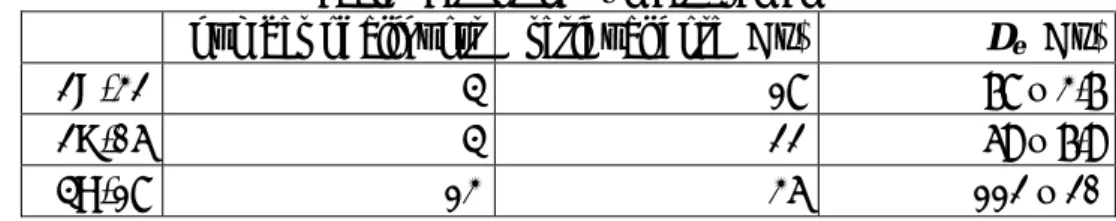
FD record is compared with Lake Baikal MS curve from BDP-93 and Baikal diatom
content as well as with some global paleoclimatic records (oxygen isotope and solar
radiation) (Figure 1). Spectral analysis of FD from the loess sequence and MS from Lake
Baikal, revealing the presence of Milankovitch signals at ~100 kyr (eccentricity), ~40 kyr
(obliquity) and ~23 kyr (precession), demonstrates that both Siberian magnetic datasets are
excellent continental recorders of global long-term paleoclimatic changes.
Figure 1. Correlation between FD parameter for Siberian loess, whole-core combined magnetic susceptibility profile for Baikal cores BDP-93-1 and BDP-93-2 in 10
-5SI Unites, biogenic silica profile from BDP-96-2 is completed by BDP-93-2 core for last 60 kyr in wt%, δO
18oxygen isotope curve from MD900963, and Solar Radiation curve for 52°N calculated from Lascar’s solution. The magnetic susceptibility is plotted on a logarithmic scale. Note reversal scales for magnetic susceptibility and oxygen isotope curve.
Stable remanence vectors of the Lake Baikal sediments (BDP-93) have been additionally studied. They are almost all of normal polarity, but several short intervals of low and/or negative inclinations are found. The most prominent of these involves a systematic inclination swing and relative intensity low near a depth of 27 m. The main part of this excursion lasted ~5000 years, but the slow recovery to typical normal polarity inclinations may double this. Our chronology suggests that this feature represents the Iceland Basin Excursion. It also implies that the corresponding intensity low in the reference global intensity pattern SINT-800 is incorrectly identified as the Jamaica/Pringle Falls Excursion and should now be re-assigned to the Iceland Basin Excursion.
Keywords: Lake Baikal, loess, magnetic susceptibility, Milankovitch cyclicity
Dammed lakes in North Asian mountains as archives of glacial and post-glacial events.
An overview of the problem.
Sergey Krivonogov
Institute of Geology and Mineralogy SB RAS, Koptuga ave., 3, 630090, Novosibirsk, Russia Tel.: +7 (383) 335-62-79; Fax: +7 (383) 3333-584; Email: [email protected]
Continuous records from lacustrine sediments are the best objectives for continental paleoenvironmental studies. Long living lakes, like the Baikal and the Hovsgol, provide us data about major climatically controlled events spanned over a million-year history. Small lakes give us detailed information about short-term climatic fluctuations and local events, mostly for the Holocene and Late Glacial intervals though. Since the Late Pleistocene glacial event the glacial maximum should be well-presented in mountainous glaciogenic lakes. The paper discusses the use of those still unpopular sequences. Our study is mostly focused on the geomorphologic evidences for the age of glaciogenic lakes and the stages of their development. A close inspection of the environmental proxies in those lakes is a matter of future investigation.
Our last studies confirmed that the maximum of the glaciation in Siberian mountains occurred in the beginning of the Late Pleistocene at ca. 110 ka BP (Krivonogov et al., 2005).
Our obtained record of three-to-four glacial events matches the conception of fluctuations in the global ice storage recorded in oceanic sediments (OIS 5d, 5b, 4, and 2). Thus, the long- living glaciogenic lakes may contain sedimentary records of those events and their fine structure. We recognize two main types of glaciogenic lakes based on their origin: ice dammed lakes and glacial moraine dammed lakes.
We suggest that locally long extended ice tongues could have dammed intermountain depressions resulting in the formation of huge long-living lakes (e.g. Chuya and Kurai Lakes in the Altai Mountains, Darhad Lake in Northern Mongolia, Chara and Muya Basins in North-Eastern Transbaikalia). Large glacial lakes could have formed inside terminal moraines (after the melting of dead ice), or in ice-plowed depressions (e.g. Nichatka, Leprindo, and Leprindokan Lakes in North-Eastern Transbaikalia, Chagan-Uzun Lake in the Altai, and Hoton Nuur Lake in the Mongolian Altai).
The lake of Darhad was formed as a giant ice-dammed and sedimentary-dammed lake probably at OIS 5d (Krivonogov et al., 2005). Tentatively we have estomated that its level has been gradually decreasing; the residual lake Dood Nuur occupies the lowermost part of the basin. The main stages of its development are recorded in the bottom sediments, which were drilled by Gillespie and Bayasgalan in October 2003. The 93 m long core is presently stored in the Institute of Geology and Mineral Resources MAS at Ulaanbaatar. It was divided between Mongolian, Russian and American scientists in November 2006, and will be studied by rock magnetic, granulometric, and palynological methods, as well as by radiocarbon and OSL dating. The 36 m thick lacustrine sequence allows us to suggest that the sedimentation rate was about 0.4 mm per year, i.e., 7-8 times higher than in the Hovsgol Lake. The Holocene history of the residual Dood Nuur Lake was studied by Dorofeyuk and Tarasov (1998). Our 2005 drilling project reveled a more complicated history of the lake: the sand layer found at different places of the lake indicated a 10-m drop of its level, i.e. recurrent changes, rather than a gradual decrease. Thus, we suggest that this event occurred after 5 ka BP.
Two lacustrine events have been recorded in the Chara and Muya basins roughly correlated
with the Early and Late Zyryanian glacial epochs (Enikeev, 1986; Kulchitsky and Orlova,
1991; Krivonogov, 2003). The lacustrine series are separated by non-lacustrine sediments of
Karginian time (14C age ~36 ka BP). The lacustrine environments in the Muya are correlated with the glacial advances in the cross-cut valley of the Oron River, downstream the Vitim River, and the situation in the Chara was similar to that in the Darhad basin.
The moraine dammed Lake Hoton Nuur in Mongolian Altai is a very promising objective for estimating the age of the glacial maximum and subsequent glaciations. The preliminary study performed by (Tarasov et al., 2000) highlighted its Holocene history. We propose a new round of investigation of this lake in the nearest future.
References.
Dorofeyuk N. I., Tarasov P. E., 1998. Vegetation and levels of the lakes in the north of Mongolia during the last 12500 years, by the data of palynologic and diatom analyses.
Stratigraphy. Geological correlation 6, 1: 73-87.
Enikeev F.I., 1986. Environment of sedimentation in Chara basin during the Late Pleistocene, Holocene. In: Voprosy geologii i metallogenii Chitinskoi oblasti. Moscow, Mihgeo RSFSR. P. 37-43. (in Russian)
Krivonogov S. K., 2001. Remains of buried forests in the Late Pleistocene sediments of Siberia. News of paleontology and stratigraphy (appendix for Russian geology and
geophysics, 42), 4, p. 143-152. (in Russian)
Krivonogov S. K., Sheinkman V. S., and Mistruykov A. A., 2005. Stages in the
development of the Darhad dammed lake (Northern Mongolia) during the Late Pleistocene and Holocene. Quaternary International 136: 83-94.
Kulchitsky A.A. and Orlova L.A., 1991. Absolute age of stump horizon in terrace-like level of the Muya valley. In: Time and age of relief (abstracts of the Irkutsk geomorphologic seminar, September, 1991). Irkutsk, 1991. P. 146-147. (in Russian)
Tarasov, P., Dorofeyuk, N. & Metel’tseva, E., 2000. Holocene vegetation and climate changes in Hoton-Nur basin, northwest Mongolia. Boreas, Vol. 29, pp. 117–126.
Keywords: Late Pleistocene, glaciation, dammed lakes
GLOBAL AND REGIONAL NATURAL CATASTROPHS IN THE CENTRAL ASIA AND THEIR REFLECTION IN SEDIMENTARY RECORDS FROM LAKE BAIKAL
AND LAKE HOVSGOL
1
Kuzmin M.I.,
2Yarmolyuk V.V.,
1Bezrukova E.V.,
1Khomutova M. Yu.
1
Institute of Geochemistry, Siberian Branch, Russian Academy of Sciences, 664033, Irkutsk, Favorsky str., 1а, Russia; [email protected]
2