Descriptions and Analytical Data of Some
Volcanic Ash Soils from East New Britain,
Papua New Guinea
著者
HIGASHI Teruo, HAYASHI Mitsuru, KISHIMOTO
Osamu, THIAGALINGAM K.
journal or
publication title
南方海域調査研究報告=Occasional Papers
volume
5
page range
179-187
URL
http://hdl.handle.net/10232/15884
Descriptions and Analytical Data of Some Volcanic
Ash Soils from East New Britain,
Papua New Guinea
Teruo HlGASHI*, Mitsuru HAYASHI**, Osamu K.ISHIMOTO***
and K. THIAGALINGAM****
Introduction
Volcanic ash soils in the tropics have now recieved great interest because of their relatively high fertility and also their intensive use for agriculture, as it is the case for
the south Pacific regions.
On an occasion of the third scientific survey of the south Pacific (October to December, 1983), conducted by Research Center for the South Pacific, Kagoshima University, Japan, some soil samples derived from volcanic ashes near Rabaul, East New Britain Province, Papua New Guinea, were collected and described. According to Bleeker (1983) four different types of volcanic ash soils were recognized in Papua New Guinea, namely Hydrandepts, Dystrandepts, Eutrandepts and Vitrandepts (in cluding Durandepts) by the use of Soil Taxonomy (Soil Survey Staff, 1975). Hydrande pts are those formed on andesitic ashes deposited during Pleistocene and typically occur in the highlands with a relatively cool and wet climate. These soils were recently studied in more detail on their mineralogy by Chartres and Pain (1984). While other three andepts are found near active volcanoes in lowland areas, especially in the Northern Province and the New Britain island. They have been developed from volcanic ashes of more recent ages. Some of these soils were studied by Parfitt (1975).
However, no comparative studies seem to have been conducted on volcanic ash soils in
the tropics and the temperate regions with special reference to the difference in their chemical fertility. This paper is a preliminary study which aim to investigate volcanic
ash soils from the viewpoint mentioned above.
Descriptions of soils
Two profiles developed from volcanic ashes at Namanula and Rakunai near * Laboratory of Soil Science. Faculty of Agriculture. Kagoshima University. Kagoshima 890. Japan * * Laboratory of Tropical Crops. Faculty of Agricullure. Kagoshima University, Kagoshima 890, Japan
* * * Laboratory of Comparative Agricullure. Faculty of Agriculture. Utsunomia University. Utsunomia
321. Japan
180
152°00'E
-4°15'S
HlGASHl et al.: Some Volcanic Ash Soils from Papua New Guinea
152 15 E
•Mt.TOYflNUMBATIR
RABAUL. JcW^WLNflMANULA
Fig. 1. Location of sample sites (closed circle) near Rabaul, East New Britain, PNG.
Rabaul, East New Britain, are described. Location of sample sites are shown in Fig. 1. The climate of this area is humid and hyperthermic (annual rainfall of 2000 to 3500
mm, and mean annual temperature of 26 to 27°C) with moderate seasonality (Bleeker and Freyne, 1981).
1. Profile at Namanula
The pedon is located at the footslope of Mt. Toyanumbatier (North Daughter)
with the elevation of about 150 m above sea level (152"11'20"E, 4°11'30"S). Slope is flat to gently sloping and the vegetation is natural grass. Parent materials are recent andesitic volcanic ashes of different textures and ages overlying older dacitic to
rhyolitic ashes of finer textures. Drainage is well drained and human influence would
be very little, if present. Date of description and sampling was November 13, 1983.
Al : Brownish black (10YR 2/2, moist); silt loam; weak fine to coarse
0-55 cm subangular blocky ; friable ; frequent fine to coarse roots; clear smooth boundary. This layer was divided into two parts acoording to the hardness checked by hands and named as All and A12, and sampled. Some rock fragments (less than 2 cm in diameter) are present in the lower
part of this horizon.
55-65 cm coarse subangular blocky plus structureless ; friable and loose ; frequent fine to medium roots; abrupt smooth boundary.
IIIC1 : Brownish black (7.5 YR 3/1, moist) ; loamy sand ; weak coarse
suban-66-106 cm gular blocky; very friable; frequent medium roots; diffuse smooth
boundary.
Upper part is more yellowish and a thin cemented pan is
present at the upper limit of this layer. Two samples were taken from upper and lower part of this layer, namely Cll and C12, respectively.
IIIC2 : Brownish gray (10YR 4/1, moist); loamy sand; weak coarse
suban-106-123 cm gular blocky plus structureless ; very friable and loose ; frequent fine to
coarse roots; abrupt smooth boundary.
IVA : Brownish black (10YR 3/2, moist); silt loam; moderate fine to
123-133 cm medium subangular blocky; friable; freguent fine to medium roots;
clear smooth boundary.
IVB : Yellowish brown (10 YR 5/6, moist); silt loam; moderate fine to
133-147 cm medium subangular blocky ; friable; frequent fine to coarse roots ; clear
smooth boundary.
IVBC : Dark grayish yellow (2.5 Y 5/2, moist); silt; weak fine to medium
147-157 cm subangular blocky; very friable; few fine roots. Many pumice gravels
(less than 5 cm in diameter) are present.
2. Profile at Rakunai
The pedon is situated at upland of about 250 m above sea level (152°06'30"E, 4° 16'30"S). Land from of the area might be formed by the deposition of volcanic ashes
in the forms of pyroclastic flows of unknown age. Slope is gently sloping and human influence would be great due to the location of sample site very near a private house, and. in addition, the area seemed to have been formerly under coconut plantation. By
field observation parent materials are volcanic ashes of dacitic to rhyolitic composi
tion, probably corresponding to the deposits found at lower part of the pedon at Namanula. Drainage is also well drained and the date of description and sampling was November 14, 1983.All : Brownish black (10 YR 3/2, moist); silt loam ; fine to coarse blocky; 0-30 cm friable to very friable; frequent fine to medium roots; clear smooth boundary. Many rock fragments (less than 2 cm in diameter) are present. A12 : Black (10 YR 1.7/1, moist); silty clay loam ; weak fine to coarse suban-30-47 cm gular blocky; friable; frequent fine to medium roots: abrupt smooth
boundary.
B21 : Brown (10YR 3.5/4, moist); silt loam; weak fine to very coarse
47-68 cm angularblocky ; friable ; common fine to medium roots ; clear smooth boundary.
B22 : Yellowish brown (10 YR 4.5/6, moist) silt loam; weak fine to coarse
68-90 cm subangular blocky; very friable; common fine to medium roots; clear smooth boundary.
182 Higashi et al.: Some Volcanic Ash Soils from Papua New Guinea
90-110 cm subangular blocky plus strutureless; very friable and loose; few fine
roots.
Analytical methods
Analytical data were obtained according to the following methods: particle size distribution by repeating dispersion and sedimentaion method with intermittent sonification at pH 4 for the separation of clay and silt fractions, and by sieving of fine
and coarse sand fractions; pH (H20) and pH (KCI) with a glass electrode pH meter in water (1:2.5) and 1 N KCI (1:2.5), and also pH (NaF) after 2 min of reaction (1 g soil/50 ml NaF); total nitrogen and carbon by the method of Kjeldahl and wet combusion with potassium dichromate, respectively; exchangeable bases by 1M ammonium acetate extraction followed by atomic absorption spectrophotometry determination of Ca, Mg, K and Na ; phosphorus retention (%) and phosphorus
sorption by the method of Blakemore (1978) and H3P04 (1:20), respectively; CEC by
measuring Ca2+ retention by repeating washing with 1 N Ca (CH3COO)2, pH 7.0, followed by repeated washing with 0.05 N Ca (CH3COO)2, pH 7.0, and then replaced with N NaCl, where excess of Ca2+ in remaining solution were substracted from Ca2+ in NaCl by weighning for CEC caluclation.
Results and discussions
General characteristics and classification of soils
Volcanic ashes deposited at Namanula above IIIC2 horizon are very recent ones, as indicated high percentage of fine and coarse sand fractions (Table lb), while below IVA horizon from the pedon at Namanula and for all horizons from Rakunai clay contents were relatively high. As mentioned earlier the parent materials of the lower
part of the profile at Namanula seemed to be identical with those of Rakunai.
For Rakunai soils the following general characteristics would be pointed out (Table la). Total C was not so high, namely only 2.26 and 5.6% for All and A12 horizon, respectively, although the color was as black as many Al horizons in Japan under humid temperate climate. Less organic matter content in All compared with that of A12 horizon is probably resulted from the decomposition of organic matter by human activity, since the area seemed to have been under coconut plantation. pH (H2 O) increased gradually with depth, from 6.33 to 7.22, but difference in pH between pH (H20) and pH (KCI) was notably high for B22 andB23 horizons, although exchange able complexes were saturated with exchangeable bases. Very strong acidic character at exchange sites of the complexes would be plausible. This tendency was also found
for IVB and IVBC horizons from Namanula. CEC varied from 13.50 to 24.12. Among
Table la. Chemical and physical properties of soils from Rakunai Soil Horizon Total Total pH Particle size distribution (%) (depth, cm) C(%) N(%) C/N coarse Fine Silt No. H20 KCI 1NaF Clay sand sand 1 All (0-30) 2.26 -6.33 5.09 9.60 30.0 34.8 27.0 8.2 2 A12 (30-47) 5.10 0.42 12.1 6.65 5.39 10.21 25.3 26.2 29.7 18.8 3 B21(47-68) 1.27 -6.66 5.17 10.15 35.9 30.2 26.1 7.8 4 B22 (68-90) 0.1 1 -7.09 4.35 8.84 -5 B23(90-110) -7.22 4.57 8.12 42.9 32.9 20.0 4.2 Soil Exchange Exchangeabl e bases Base P reten P sorp No. (depth, cm) acidity Ca Mg K ne/IOC Na )g soil sum LCI satu. • (%) tion (%) (m tion g/lOOg) 1 All (0-30) 0.07 7.12 1.29 0.78 0.22 9.41 13.50 69.7 56.8 884 2 A12 (30-47) 0.10 13.18 1.80 0.44 0.38 15.80 24.14 65.5 91.7 1482 3 B21(47-68) 0.18 5.62 1.68 0.91 0.38 8.59 13.70 62.7 82.9 1679 4 B22 (68-90) 0.30 6.94 4.24 5.29 0.52 16.99 17.13 99.2 32.1 754 5 B23(90-110) 0.11 4.39 1.17 2.91 0.21 8.68 7.06 100.0 -621
184 HiGASHi et al.: Some Volcanic Ash Soils from Papua New Guinea
were also high for lower part of this profile. It is worth to mention here that base saturation was high through profile, even exceeding 100% in the lower part of this pedon from Rakunai. This phenomena is in contrast to the soils in Japan and also
found for the samples from Namanula (Table lb). The presence of dry season resulting
in the change in water movement together with high weatherable minerals content would be one of reasons for this tendency, although high rainfall is recorded in the
areas studied.
For Namanula soils clay content, CEC, and total carbon were so low for the
samples above IIIC2 horizons (Table lb), indicating to be unweathered materials, which are probably from the eruption of Vulcan Crater in 1937. General characteristics
for IVA,IVB and IVBC horizons were the same as for those of Rakunai soils.
Classification of the soils studied is tentatively named as Typic Troporthents and Typic
Eutrandepts for Namanula and Rakunai soils, respectively, according to Soil Taxon omy. Recently so-called "Andisol" proposal has recieved much attention, an attempt to
create a new order in Soil Taxonomy. The soils from Rakunai are hardly to fulfill the
reguirements of diagnostic properties of ECDAM (Blakemore, 1978), except for pH
(NaF) of major part of the pedon up to 68 cm from the surface being more than 9.4 and for P-retention (%) of A12 being more than 90%. Moreoever, variable charge is far from the reguirement. Of course the soils from Namanula did not fulfill any reguirements of ECDAM, except pH (NaF) for some samples.
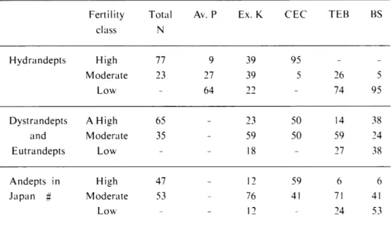
Chemical fertility of volcanic ash soils
Although a term fertility is difficult to define, nutritional status of soils could be
taken as chemical fertility which is shown by such analyes as CEC, total exchangeable bases (TEB), degree of base saturation (BS), exchangeable potassium, available phos
phorus and content of total nitrogen. Bleeker (1983) proposed three classes for each
analytical item (Table 2). In Table 3, results of chemical fertility of the volcanic ash soils, andepts, in Papua New Guinea (Bleeker, 1983) and also of those from Japan (Wada, 1983) are shown together for a comparison. It is evident that high total nitrogen, and moderate to high CEC and exchengeable potassium are characteristic of the andepts in both countries. As for TEB and BS the andepts in Japan seem to be in the middle position between Hydrandepts and other andepts in papua New Guinea. A relatively poor base content in the andepts from Japan compared with Dystrandepts
and Eutrandepts in Papua New Guinea may be resulted from the difference in climate
conditions and also in the composition of amorphous inorganic constituents which are closely related to the development of negatively charged surfaces for the retention of
bases. The soils from Namnanula and Rakunai showed moderate to high fertility level
for each item, although CEC from Namanula was in low level. However, in general, volcanic ash soils are relatively rich in chemical fertility. It is interesting to mention
here that most of the areas of andepts in Papua New Guinea are mapped as no limitation lands in the land limitation map produced by Bleeker (1975) and are most suitable for cocoa production (Bleeker and Freyne, 1981).
Table lb. Chemical and physical properties of soils from Namanula Soil Horizon (depth, cm) Total C(%) Total N(%) C/N pH Particle size distribution (%) coarse sand Fine sand Silt Clay No. H,0 KCI NaF 1 All (0-28) 1.49 0.12 12.4 7.47 5.92 9.65 11.8 73.8 11.6 2.8 2 A12 (28-55) 0.45 0.04 11.3 6.72 5.40 9.45 12.8 74.4 10.5 9 3 3 II (B)C (55-66) 0.40 0.04 10.0 6.72 5.36 9.51 25.2 59.8 12.4 2 6 4 IIICI1 (66-86) 0.19 -6.72 5.29 9.23 26.0 60.4 11.8 1 8 5 IIICI2 (86-106) 0.07 -6.72 5.14 8.88 27.1 60.6 10.9 1 4 6 IIIC2 (106-123) -6.70 5.17 8.85 26.8 56.5 15.1 1 6 7 IVA (123-133) 2.58 0.19 13.6 6.31 4.68 9.98 18.1 45.0 23.0 13 9 8 IVB (133-147) 0.76 -6.69 4.37 9.32 19.1 39.2 34.6 7 1 9 IVBC (147-167) 0.06 -7.10 4.40 8.08 23.2 46.3 24.0 6 5 Soil Horizon (depth, cm) Exchange acidity Exchangeable bases CEC Base satu. (%) P reter tion (%) -( P sorp tion mg/lOOg) No. Ca Mg me/100 g K Na sum 1 All (0-28) 0.06 3.15 0.61 0.37 0.03 4.16 4.89 85.1 24.6 384 2 AI2 (28-55) 0.06 1.45 0.12 0.25 0.06 1.88 2.92 64.4 22.3 536 3 II (B)C (55-66) 0.06 1.32 0.12 0.20 0.07 1.71 3.04 56.3 28.5 435 4 IIIC11 (66-86) 0.07 1.22 0.06 0.15 0.10 1.53 1.41 100.0 14.2 194 5 IIIC12 (86-106) 0.06 0.40 0.04 0.08 0.10 0.62 0.83 74.7 2.2 72 6 IIIC2 (106-123) 0.08 0.64 0.07 0.18 0.09 0.98 1.13 86.7 3.1 72 7 IVA (123-133) 0.31 7.43 1.12 2.33 0.83 11.71 18.80 62.3 69.9 1402 8 IVB (133-147) 0.61 5.04 1.70 2.26 1.78 10.78 16.65 64.8 46.6 914 9 IVBC (147-167) 0.15 7.01 2.70 1.46 1.26 12.43 12.28 100.0 -223
186 HiGASHl et al: Some Volcanic Ash Soils from Papua New Guinea
Table 2. Analytical parameters used for assesment of chemical fertility
Fertility class Total N (%) Avail able P (ppm) Exchangeable potassium me/100 e CEC TEB BS High 0.50 50 0.6 25 25 60 Moderate 0.10-0.50 10-50 0.2-0.6 6-25 3-25 20-60 Low 0.10 10 0.2 6 3 20
Table 3. Chemical fertility data (top soil, normally 0-50 cm)
Fertility Total Av. P Ex. K CEC TEB BS
class N Hydrandepts High 77 9 39 95 - -Moderate 23 27 39 5 26 5 Low - 64 22 - 74 95 Dystrandepts A High 65 - 23 50 14 38 and Moderate 35 - 59 50 59 24 Eutrandepts Low - - 18 - 27 38 Andepts in High 47 - 12 59 6 6 Japan # Moderate 53 - 76 41 71 41 Low - - 12 - 24 53
Figures are the percentage of the number of samples belong to respective classes. # Data from the report on the international correlation studies on Kurobokudo and
related soils, supported by a grant from Science Research Fund o\^ Japanese Ministry of Education, No. 56360006 (K. Wada. 1983).
Acknowlegement
The authors wish to express sincere thanks to David F. Freyne, Chief Land Utildzation Officer of Department of Primary Industry, Land Use Section, Papua New Guinea, for his helpful guidance for the soils in Papua New Guinea, and also to Mr. Y. Beppu for the assistance of analyses of the samples studied.
References
Blakemore, L.D. 1978. Exchange complex dominated by amorphous material
(ECDAM). Unpublished paper. 2 pp.
Bleeker, p. 1975. Explanatory notes to the land limitation and agricultural land use potential map of Papua New Guinea. CSIRO, Land research Series No. 36.,
5-16. CSIRO, Melbourne.
Bleeker, p. 1983. Soils of Papua New Guinea. 67-91. ©, CSIRO ; printed by Macarthur
press for the Australian National University press, Canberra.
Bleeker, p. and Freyne, D.F. 1981. Areas Suitable for Cocoa production in Papua New
Guinea. Department of Primary Industry, Papua New Guinea.
Chartres, C.J. and Pain, C.F. 1984. A climosequence of soils on late Quaternary volcanic ash in highland Papua New Guinea. Geoderma, 32., 131-155.
Parfitl, R.L. 1975. Clay minerals in recent volcanic ash soils from Papua New Guinea. InR.P. Suggate and M.M. Cresswell (Editors), Quaternary Studies, R. soc. N. Zd.
Bull., 13., 241-245.
Soil Survey Staff. 1975. Soil Taxonomy. U.S. Department of Agr., Agriculture Hand
book No.436. 230-236. U.S. Gov. Printing Office, Washington, D.C.
Wada, K. 1983. The report on the international correlation studies of kurobokudo and their related soils. Unpublished paper. 61 pp.