59
Important Cultural Landscape List and the Decay of Traditional Agricultural Life:
A Case of Dispersed Settlement in the Tonami Plain, Japan
Koshiro Suzuki
Associate Professor, Faculty of Humanities, University of Toyama, Japan [email protected]
Abstract
In 2004, Japanese Law for the Protection of Cultural Properties was partially revised to include the idea of cultural landscape. Based on the revision, the Japanese Minister of Education, Culture, Sports and Science became capable of selecting Important Cultural Landscape for preservation of a distinctive land use form associated with its regional culture, custom, and beliefs. The new ideology toward landscape, cultural landscape was diffused from UNESCO via the national authority to local governments in top-down manner, at the time of the revision of Japanese landscape law to include the cultural landscape concept in 2004. Consequently, Japanese local authorities have gradually imported the concept via the application process of ICL whereas the Japanese government also had been espoused it from UNESCO. In the light of these circumstances, the purpose of this paper is to assess the effectiveness of the concept of conserving local landscapes, by grading them according to a globalized evaluation system, using the Tonami plain as a case study. In doing this, the author also critically investigates the historical origin, status quo, and prospects of ICL.
Key words: Cultural landscape, Conservation, World heritage, Cultural inevitability
Introduction
In 2004, Japanese Law for the Protection of Cultural Properties was partially revised to include the idea of cultural landscape. It further defined the landscape as “the scenic place shaped by the people’s lives and vocations as well as regional climate of which are essential to understand Japanese way of life and vocation”.
Based on the first clause of Article 134 of the same law, the Minister of Education, Culture, Sports, Science became capable of selecting Important Cultural Landscape (ICL) for preservation of a distinctive land use form
60
associated with its regional culture, custom, and beliefs. As listed on Table 1, ICL consists of rice terraces, villages, and river basins. They are not only chosen because they are rare and wonderful in themselves but represent a local way of traditional life in their land use form. On January 26th 2006, the Wetland in Omi-hachiman was registered as the first ICL. Since then, thirty areas have been on an on-going basis selected as ICL until April 2012.
Before the amendment of Japanese Law for the Protection of Cultural Properties, the Agency for Cultural Affairs had done a series of research studies to select possible ICL places from more than 2,000 candidate sites (Section for Monuments and Sites, Division of Cultural Property, Agency for Cultural Affairs 2005). Many municipalities started to act in concert with the new initiative by promoting their potentially valuable assets to be chosen on the ICL list.
In the light of these circumstances, the purpose of this paper is to assess the effectiveness of the concept of conserving local landscapes, by grading them according to a globalized evaluation system, using the Tonami plain as a case study. In doing this, the author also critically investigates the historical origin, status quo, and prospects of ICL.
Origin of ICL
Cultural landscape ideology derived from UNESCO
The term and some fundamental idea of cultural landscape were coined by a famous geographer Carl O. Sauer in 1925 (Sauer 1925). He explained that spatial observation should be based on recognizing the integration of physical and cultural foundations of the landscape. The direct origin of the cultural landscape is traceable back to 1962 when UNESCO adopted the Recommendation Concerning the Safeguarding of the Beauty and Character of Landscape and Sites at the 12th general conference of UNESCO. That was 10 years before the coming into effect of the Convention concerning the Protection of the World Cultural and Natural Heritage. Article 1 of the recommendation defined the landscape worth protecting as “the preservation and, where possible, the restoration of the aspects of natural, rural and urban landscapes and sites, whether natural or man-made, which have a cultural or aesthetic interest or form typical natural surroundings”, and in article 3, they quoted defined the landscape worth protecting as “the preservation and, where possible, the restoration of the aspects of natural, rural and urban landscapes and sites, whether natural or man-made, which have a cultural or aesthetic interest or form typical natural surroundings”, and in article 3, they quoted
61
that the safeguarding process should “extend to the whole territory of a state, and should not be confined to certain selected landscapes or sites” (UNESCO 1962: 2).
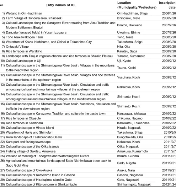
Table 1. Inscribed landscapes on ICL list
The idea of combining cultural and nature conservation was initially proposed in 1965 by a U.S. Committee on Natural Resources Conservation and Development in the White House Conference on International Cooperation.
The committee called for a World Heritage Trust to stimulate “international cooperative efforts to identify, establish, develop and manage the world’s superb natural and scenic and areas and historic sites for the present and
No. Entry names of ICL Location
(Municipality/Prefecture)
Inscription date
1) Wetland in Omi-hachiman Omi-hachiman, Shiga 2006/1/26
2) Farm Village of Hondera area, Ichinoseki Ichinoseki, Iwate 2006/7/28
3) Cultural Landscape along the Sarugawa River resulting from Ainu Tradition and
Modern Settlement Biratori Biratori, Hokkaido 2007/7/26
4) Danbata (terraced fields) in Yusumizugaura Uwajima, Ehime 2007/7/26
5) Tono Arakawakogen Farm Tono, Iwate 2008/3/28
6) Waterfront of Kaizu, Nishihama, and Chinai in Takashima City Takashima, Shiga 2008/3/28
7) Ontayaki Village Hita, Oita 2008/3/28
8) Rice terraces in Warabino Karatsu, Saga 2008/7/28
9) Landscape with Tsujun irrigation channel and rice terraces in Shiraito Plateau Yamato, Kumamoto 2008/7/28
10) Cultural Landscape in Uji Uji, Kyoto 2009/2/12
11) Cultural landscape in the Shimantogawa River basin. Villages in the mountains
to the headwater region Tsuno, Kochi 2009/2/12
12) Cultural landscape in the Shimantogawa River basin. Villages and rice terraces
in the mountains at the upstream region Yusuhara, Kochi 2009/2/12
13) Cultural landscape in the Shimantogawa River basin. Circulation and traffic
among agricultural and mountainous villages at the upstream region Nakatosa, Kochi 2009/2/12 14) Cultural landscape in the Shimantogawa River basin. Circulation and traffic
among agricultural and mountainous villages at the middlestream region Shimanto, Kochi 2009/2/12 15) Cultural landscape in the Shimantogawa River basin. Vocations, circulation and
traffic in the downstream region Shimanto, Kochi 2009/2/12
16) Cultural landscape in Kanazawa. Tradition and culture in the castle town Kanazawa, Ishikawa 2010/2/22
17) Rice terraces in Obasute Chikuma, Nagano 2010/2/22
18) Rice terraces in Kashihara Kamikatsu, Tokushima 2010/2/22
19) Cultural landscape in Hirado Island Hirado, Nagasaki 2010/2/22
20) Waterfront of Harie and Shimofuri Takashima, Shiga 2010/8/5
21) Rural landscape of Tashibunosho Osaki Bungotakada, Oita 2010/8/5
22) Kure port and fishing townscape Nakatosa, Kochi 2011/2/7
23) Cultural landscape of the Ojika islands Ojika, Nagasaki 2011/2/7
24) Fishing village of Sakitsu, Amakusa Amakusa, Kumamoto 2011/2/7
25) Wetland of meeting of Tonegawa and Watarasegawa Rivers Itakura, Gunma 2011/9/21 26) Agricultural and mountainous landscape of Sado Nishimikawa trace back to
Sado Gold Mine Sado, Niigata 2011/9/21
27) Cultural landscape of Oku-Asuka Asuka, Nara 2011/9/21
28) Cultural landscape of Kuroshima Island in Sasebo Sasebo, Nagasaki 2011/9/21
29) Cultural landscape of Hisakajima Island in Goto Goto, Nagasaki 2011/9/21
30) Cultural landscape of Kita-uonome in Shinkamigoto Shinkamigoto, Nagasaki 2012/1/24 As of April 2012 (Source: Agency for Cultural Affairs 2012. Policy of Cultural Affairs in Japan ― Fiscal 2012)
62
future benefit of the entire world citizenry” (Stott 2011: 283). The International Union for Conservation of Nature also developed similar proposals in 1968.
Subsequently, The Convention concerning the Protection of the World Cultural and Natural Heritage was adopted by the General Conference of UNESCO on 16 November 1972.
In 1992, at the time when Japan ratified the world heritage treaty, at the 16th general conference, UNESCO added and redefined cultural heritage to cultural property in the revision of their operational guideline (Takahashi 2009; Rӧssler 2002: 10-11). Cultural landscape is a local environment which can only be sustained by the dynamic interaction between socio-cultural folkways and nature, such as rice terraces and village forests. According to UNESCO, it consists of three categories: (1) Landscape designed and created intentionally by humans, such as parks and gardens, (2) Organically evolved landscape, and (3) Associative cultural landscape. The second type also consists of (a) Relict/fossil landscape, such as archaeological sites, and (b) Continuing landscape that “retains an active social role in contemporary society closely associated with the traditional way of life” (Rӧssler 2000: 27-28). These classifications, especially for the last one, equally associate with additional distinctions, such as vernacular assets, as we shall see in the following case study in Tonami, Japan.
Origin of Japanese law for conserving local landscape
The revolutionary period of modernization in which aspects of western systems and culture entered into Japan, called the Meiji-Ishin (Meiji restoration) dated from 1868. Likewise, the modernization in Japanese legal history of environmental conservation also can be dated back to 1897 when the Meiji-restoration government initially started to employ the Traditional Temples and Shrines Conservation Act for preserving old architecture of Buddhist temples and Shinto shrines and their treasury as national properties. The act was abolished and incorporated into the National Treasury Preservation Act of 1929, which accredits cultural properties regardless of their ownership (Kobayashi 2007).
In 1919 the Historical Site, Scenic Beauty and Natural Monument Preservation Law was congressionally-sanctioned and enacted (Edagawa 2002).
Although “Historical Spot” and “Natural Monument” imply the indicated objects, it is difficult to represent any figurative referent of “Scenic Beauty”. It can be recognized as the legal birth of landscape conservation ideology in Japan.
63
In 1950, when the Cultural Assets Preservation Act gained approval as lawmaker-initiated legislation, the two previous Acts enacted in 1919 (mainly for natural resources) and 1929 (mostly for national treasury) were united.
Subsequently the 1950 act had several revisions. Notably the amendment in 1975 included the institution of Ju-denken: Important Preservation District of Historic Buildings and Ju-Yo- Mukei Bunka Zai: Intangible Important Cultural Property (Kariya 2008) for comprehensive and unified conservation of important cultural architectures and their surrounding areas.
Initiation of cultural landscape into Japanese landscape law
Up to the major amendment of the cultural assets preservation act in 2004 to include newly-initiated cultural landscape ideology in Japanese Law for the Protection of Cultural Properties, local environment had only been viewed to be the set of cultural property and their surrounding neighborhood. Through the amendment, cultural landscape was addressed as a category of cultural property in its first clause of Article 2 (Section for Traditional Culture, Agency for Cultural Affairs 2005). Article 5 of the law further defined the landscape as
“the scenic place shaped by the people’s lives and vocations as well as regional climate which are essential to understand the Japanese way of life and vocation”. More precisely, the agency categorized cultural landscapes associated with (1) agricultural life such as rice terraces and dry fields, (2) plant cropping such as Japanese nutmeg fields for traditional roof-thatching and meadowlands, (3) forestry for timber and disaster-prevention forests, (4) culture fishery such as aquafarming of seaweeds and pearls, (5) water usage such as irrigation ponds, canals and harbors, (6) mining and manufacturing industrial plants and collieries, (7) flow and mobilization of people such as road and plaza space, (8) residences such as planting fences and homestead woodlands.
The new ideology toward landscape, cultural landscape was diffused from UNESCO via the national authority to local governments in top-down manner, at the time of the revision of Japanese landscape law to include the cultural landscape concept in 2004. Consequently, Japanese local authorities have gradually imported the cultural landscape concept via the application process of ICL whereas the Japanese government also had been espoused it from UNESCO.
Study area and its adoption process of ICL
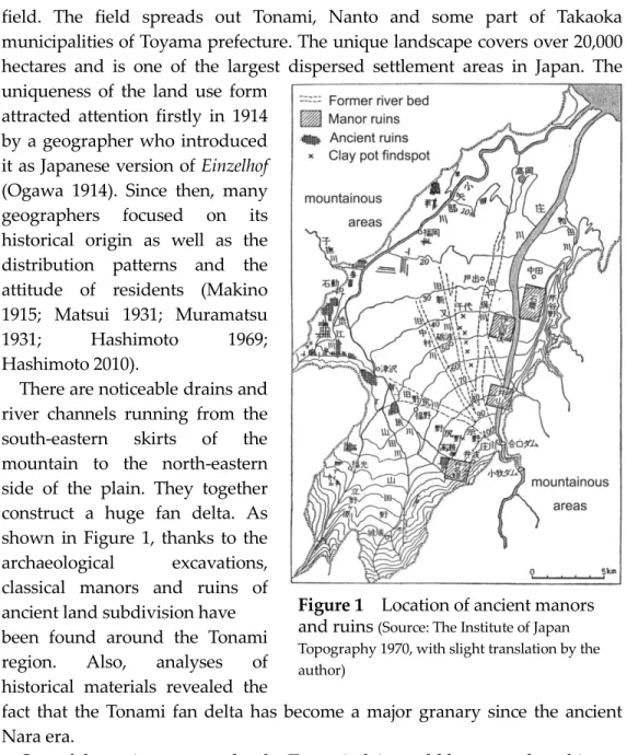
The Tonami dispersed village landscape is roughly located in the Tonami plain
64
Figure 1 Location of ancient manors and ruins (Source: The Institute of Japan Topography 1970, with slight translation by the author)
field. The field spreads out Tonami, Nanto and some part of Takaoka municipalities of Toyama prefecture. The unique landscape covers over 20,000 hectares and is one of the largest dispersed settlement areas in Japan. The uniqueness of the land use form
attracted attention firstly in 1914 by a geographer who introduced it as Japanese version of Einzelhof (Ogawa 1914). Since then, many geographers focused on its historical origin as well as the distribution patterns and the attitude of residents (Makino 1915; Matsui 1931; Muramatsu 1931; Hashimoto 1969;
Hashimoto 2010).
There are noticeable drains and river channels running from the south-eastern skirts of the mountain to the north-eastern side of the plain. They together construct a huge fan delta. As shown in Figure 1, thanks to the archaeological excavations, classical manors and ruins of ancient land subdivision have been found around the Tonami region. Also, analyses of historical materials revealed the
fact that the Tonami fan delta has become a major granary since the ancient Nara era.
One of the main reasons why the Tonami plain could become a long history of grain-growing region is its topographical conditions. Because the huge delta is surrounded by mountains, it is easy for the residents to obtain sufficient water and nutrient supply in the Tonami plain, and they did not need to live collectively. Consequently, in the Tonami region, each farm is surrounded with their arable land and creeks, which isolates them from each other. The origin of such a land ownership system came not only from natural conditions such as abundance of water but the implementation of land
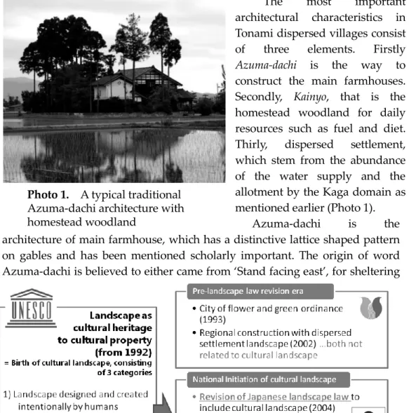
65 Photo 1. A typical traditional Azuma-dachi architecture with homestead woodland
allotment by the Kaga-domain: a sort of regional government of Samurais. The name of this system is Kochi-igyo-sei.
The most important architectural characteristics in Tonami dispersed villages consist of three elements. Firstly Azuma-dachi is the way to construct the main farmhouses.
Secondly, Kainyo, that is the homestead woodland for daily resources such as fuel and diet.
Thirly, dispersed settlement, which stem from the abundance of the water supply and the allotment by the Kaga domain as mentioned earlier (Photo 1).
Azuma-dachi is the architecture of main farmhouse, which has a distinctive lattice shaped pattern on gables and has been mentioned scholarly important. The origin of word Azuma-dachi is believed to either came from ‘Stand facing east’, for sheltering
Figure 2. Illustration of the receptive process of cultural landscape ideology from UNESCO to Tonami municipality
66 Figure 4. Trends of classified
numbers of Farms in Tonami city
the entrance from the seasonal westward wind, or Azuma-date, which implies a construction form of samurai residences in the Kanazawa area (The Institute of Tonami Dispersed Region 2010).
Since the initial launch of the ICL list in 2006 by the Cultural Affairs Agency, the cultural landscape ideology was gradually diffused in the form of a list inclusion process.
In the case of Tonami, when the agency announced that the eight sites reached the shortlist for
recommending further
investigation in 2005, the dispersed settlement landscape in Tonami plain still remained on the list (Section for Monuments and Sites, Division of Cultural Property, Agency for Cultural Affairs 2005). Subsequently, the Tonami municipal office set up the investigative commission of dispersed settlement landscape conservation in August 2006.
Although Tonami municipality had previously operated some ordinances independently, the installation of the commission was the first effort to be chosen on the list (Figure 2). The commission has subsequently conducted measurement surveys on actual condition and attitude of the residents from 2006 to 2007, and detailed model areas analysis in 2008. Then, in March 2009, the Tonami municipality published a research report (Tonami City 2009) demonstrating the historical, cultural, and architectural importance of the landscape which was finalized in line with these achievements as above.
0 1 2 3 4 5
0 4000 8000 12000 16000 20000
1980 1990 1995 2000 2005 2010 Total Households Av.Household size/Unit (units)
(year) ( / unit)
0 500 1000 1500 2000 2500 3000 3500 4000 4500 5000
1980 1990 1995 2000 2005 2010 Other
side-farming parttime farmer farm-main parttime farmer fulltime
(year) (farms)
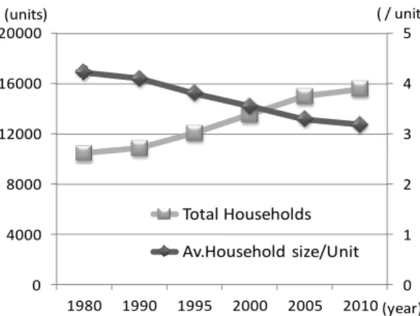
Figure 3. Demographic movement of households in Tonami city
67 Discussion
According to the research report, there are three key elements that make Tonami dispersed settlement deserving to be ICL: Kainyo; Farmers' house surrounded by residential trees, paddies with dispersed settlement; and Azumadachi, architecture of farm houses. Although all of these three elements still largely remain, there are some challenges for conserving them as constructs of the cultural landscape. All of the three elements are strongly related to traditional way of agricultural life in the region. While the demographic movement in Tonami is slightly in upward trend generally, statistics show an increase in nuclear families and in ‘graying’ (Figure 3). The trend is not due to the success of traditional farming. In fact agricultural census revealed a continuous decline of farming. Notably, farmers who have smaller farms and who are more likely not to be capable of earning their living, are more likely to quit farming (Figure 4).
In the case of Yashiki-rin, it was initially planted not only for protecting the farmhouses from southern and western winds, but to utilize dead leaves and branches for fuel resources for the kitchen and bath or as a shade grove. Since modern electricity and gas became available and insulation of houses has been enhanced, to maintain the forest is not cost-effective. As long as the landowner chooses to continue maintaining the house forest, it is necessary to keep pruning overgrown branches and removing fallen leaves. Because the work cannot be done without the help of professional landscape gardeners, it has become a heavy burden for the landlord.
In paddies with dispersed settlement, the agricultural land has gradually been converted to houses built for sale and small industrial plants, mainly due to the recent set-aside policy and price competition with imported crops. It gradually contributes to degradation of the landscape.
Figure 5. Kokan-bungo, before and after (Source: Shindo 2013: 60)
68
The recent reorganization /consolidation of land ownership and readjustment/reshaping of the field plots already differentiated the landscape when viewed close-up although there appears to be no change when viewed from a distance (Figure 5). There was a huge land ownership exchange project called Kokan-bungo that took place from 1962 to 1990 in Tonami. The farmland layout was drastically straightened for mechanization. It is called hojo-seibi.
Consequently, although the dispersed settlement form still largely exists there, the detailed configuration of the landscape was changed considerably.
Likewise, the roofs of Azumadachi today are tiled although it was gradually changed from thatched reed from around 100 years ago. They pose a problem of landscape authenticity. However, the house originally had a thatched roof, and then shifted to clay tile roofing from 1887 and totally shifted around the 1960s (The Institute of Tonami Dispersed Region 2010).
In consequence, although Tonami dispersed settlement as a physical appearance still largely exists there, its cultural landscape in practice is gradually transforming into something like a papier-mache tiger. In order to protect the dispersed settlement in Tonami plain practically as a cultural landscape, it is crucial to provide adequate policy support for the landowners to enhance the necessity to maintain the landscape as a reasonable construct of their social and cultural life rather than to try simply keeping the appearance of the landscape.
Concluding Remarks
Although it was more than a half century ago when Sauer (1925) coined the term and the fundamental concept, cultural landscape is rapidly gaining a great significance in conserving our daily landscape mainly due to the designation of by UNESCO and the relevant authorities. In a certain aspect, the certification certainly opens the new possibilities of the target area as the rural and heritage tourism sites with conserving the vernacular assets of the landscape. In fact, previous researches reported the attempts to find the new value of the places in the light of cultural landscape. Buckley et al. (2008) intended to re-evaluate the unique steppe plain landscape of Mongolia as the tourism resource by statistic analyses of data and materials provided by tourism-related industries and local governments. Likewise Stenseke (2009) reported a successful maintenance of authorized pasture landscape that is maintained by the participatory approach in the southern Sweden. However, such expansion of the global grading system also enhances potential risk of restricting the living rights of more people in wider region through the
69
macroscopic interest and the immensely-privileged power to modify the relevant legal systems.
As previously stated, to conserve the vernacular cultural built heritage in the Tonami plain, it is crucial to conserve its dynamic interaction between natural and socio-cultural way of local life. In this paper, the author critically investigated some challenges of diffusing the ICL concept by highlighting Tonami dispersed settlement as a case study. Farmers in Tonami have lived separately, facing east, surrounded by trees, because of their cultural inheritance. Therefore it can be defined as cultural landscape. But the meaning is diminishing because the number of farmers is decreasing at a rapid rate.
Although Azuma-dachi and dispersed settlement still exist, the requirements for them no longer exist. Their houses are too large as nuclear family houses so that they are gradually replaced by smaller ready-built houses for nuclear families. Even for farmers’ who still farm, electricity and gas have changed their lifestyles. Therefore the cultural inevitability of keeping the homestead woodland has gone.
To conserve Tonami dispersed settlement as a cultural landscape, implement of policies should provide farmers to have regenerated inevitability, raison d'être of the landscape constructs.
References
Buckley R, Ollenburg C and Zhong L 2008 Cultural landscape in Mongolian tourism Annals of Tourism Research 35(1) 47-61
Edagawa A 2002 A study of the histrical development of the cultural properties protection in Japan: In the view of the time before World War II Bulletin of the Faculty of Cultural Information Resources, Surugadai University 9(1) 41-47 (J) Hashimoto S 1969 A social geography of the social structure of a dispersed
village Japanese Journal of Human Geography 21(6) 547-574 (J)
Hashimoto S 2010 The things that Tonami dispersed village told Bulletin of the Institute of Tonami Dispersed Region 27 9-16 (J)
Kariya I 2008 New horizon of preservation and utilization of architectural heritage Policy Science 15(3) 57-76 (J)
Kobayashi T 2007 Environmental conservation and formation policies in Japan Reference 672 48-75 (J)
Makino S 1915 About the dispersed settlement system of Kaga-domain. Journal of Geography 27 684-692 (J)
Matsui I 1931 Statistical study on the distribution of dispersed settlement in the Tonami plain Geographical Review of Japan 7 459-476
70
Muramatsu S 1931 About the dispersed settlement in the Tonami plain History and Geography 28(4) no page number (J)
The Institute of Japan Topography ed 1970 Topography in Japan vol.10 Ninomiya-Shoten, p.122 (J)
Ogawa T 1914 About the homesteads in the western Ecchu region Journal of Geography 26 859-905 (J)
Rӧssler M 2000 World heritage cultural landscapes The George Wright Forum 17(1) 27-34
Rössler M 2002 Linking nature and culture: World heritage cultural landscapes.
UNESCO World Heritage Papers 7 10-15
Sauer, C.O 1925 The morphology of landscape University of California Publications in Geography 2(2) 19-54
Section for Monuments and Sites, Division of Cultural Property, Agency for Cultural Affairs 2005 Japanese cultural landscape - Research Report on the protection of cultural landscapes related to agriculture, forestry and fisheries. Tokyo, Dosei Sha (J)
Section for Traditional Culture, Agency for Cultural Affairs 2005 A partial revision of the law for the protection of cultural properties Gekkan Bunkazai 500 15 (J)
Shindo M 2013 Change of Dispersed village from the beginning of Meiji period Handouts of historical geographers Inspection Tour 57-62 (J)
Stenseke M 2009 Local participation in cultural landscape maintenance:
Lessons from Sweden Land Use Policy 26 214-223
Stott, P.H 2011 The world heritage convention and the national park service, 1962-1972 The George Wright Forum 28(3) 279-290
Takahashi A 2009 Study on cultural heritage risk management and integrated application of UNESCO's International Conventions: the 1954 Hague Convention, the 1970 Convention, and the 1972 World Heritage Convention.
Journal of Architecture, Planning and Environmental Engineering: Transactions of AIJ 74 1945-1950 (J)
The Institute of Tonami Dispersed Region ed 2010 The dispersed settlement on the Tonami plain: revised edition The Institute of Tonami Dispersed Region.
Tonami City ed 2009 The research report for conservation and utilization of dispersed landscape Tonami City (J)
UNESCO 1962 Recommendation concerning the Safeguarding of Beauty and Character of Landscapes and Sites UNESCO Archives 12C/40 1-7