64
DOI: http://dx.doi.org/10.14246/irspsd.2.2_64
Copyright@SPSD Press from 2010, SPSD Press, Kanazawa
The Influence of Metro Station Development on Neighbourhood Quality
The Case of Tehran Metro Rail System
Reza Kheyroddin
1, Aliakbar Taghvaee
2, Amir Forouhar
3*1 Assistant Professor in Urban and Regional Planning, Iran University of Science and Technology, Tehran, Iran
2 Associate Professor in Urban Planning, Tarbiat Modares University of Tehran, Iran 3 Master Degree in Urban Planning, Tarbiat Modares University of Tehran, Iran
* Corresponding Author: E-mail: [email protected] Received 27 September, 2013; Accepted 23 January 2014
Key words: Transit Oriented Development, Spatial Segregation, Neighbourhood Quality, Land Value, Metro Station, Tehran, Iran.
Abstract: Introducing urban public transportation facilities into a region often creates a significant opportunity to accelerate the process of development through affecting on the property values. Better access, more mobility options, and lower transportation costs are important factors that increase the land values of such regions, especially in blighted and poor neighbourhoods. This issue is important in Tehran Metropolis, because during the past decades an obvious kind of spatial segregation has been formed between the rich north (with high spatial quality) and the poor south (with low spatial quality) due to unequal distribution of opportunities and resources. On the other side, according to the population demand, Metro System is being developed rapidly in the city. Thus a comparative field study on the impacts of metro stations on property values in Tehran can represent not only the various impacts of metro station establishing on different urban textures, but also its consequences on reducing the spatial segregation in the city. We presume that the poor areas under discussion (southern regions) have received more benefits than the rich areas in terms of residential property values. So, establishing of metro stations in the poor and blighted regions of the city can improve the development potentials at these areas. Such improvement in spatial quality of the southern neighbourhoods of the city can reduce the spatial segregation in Tehran Metropolis. The hypothesis has been tested with a field study around Shari'ati Street Metro Station (in the northern part of Tehran) and Shohada Square Metro Station (in the southern part) with considering the quantitative (polynomial regression) and qualitative (personal interview) methods of impact assessment. The results show that establishing of metro stations has a consistently higher positive impact on the residential property values at the poor regions compared with the rich areas. Therefore, by means of acceleration in the values of the poor southern regions, Tehran's long-standing segregation will gradually diminish and subsequently the spatial urban integration will show itself, though in a rather long time.
1. INTRODUCTION
A transportation system can make various impacts on surrounding areas.
These impacts sometimes appear around stations, sometimes around transit
corridors and in some cases as a combination of both. Metro Rail System is one the most widely used mode of public transportation. So that during the recent decades, development of metro networks in urban regions has significantly affected on spatial flows and urban mobility as well as spatial development of urban areas. Improving availability of employment nucleuses, retail districts and essential facilities for citizens is the most obvious impact of this development. Such positive impacts can raise land values around metro stations and consequently it can provide especial opportunities for urban textures to improve their quality. In fact, metro stations can play an important role to develop their surrounding areas especially in the economic aspects. This opportunity is very important for urban textures, particularly for poor and blighted textures that faced with many obstacles in attracting investment for regeneration and renewal. So an intelligent management around the metro stations can change the state of blighted and run-down textures to livable and dynamic districts.
2. RESEARCH METHODOLOGY
The quality of urban areas is reciprocally associated with land values, so that any change in spatial quality of urban textures shows itself in property prices (especially residential properties) and mutually increase or decrease in the land values due to its impact on the rate of development, can improve or descend the quality of areas. In fact, the property values can be varied according to the spatial quality (social, economic and physical) of their surrounding areas (Tyrvainen, 1997). So that on researches about the quality of life, the housing price is considered as the maximum cost that people are willing to pay for living in a place with better quality and more facilities (Geoghegan et.al, 1997). So it can be stated that Housing Price Index (HPI) is one of the most comprehensive indicators for measuring the level of neighbourhoods' quality (Bourdin, 2008). Therefore, in the present study to assess the qualitative changes in the vicinity of Tehran's metro stations the HPI is analysed using Statistical Correlation Analysis Methods and Polynomial Regression. Comparing the results of the northern regions and southern regions -which are dramatically different in terms of socioeconomic prosperity and physical quality-, can represent the consequence of this development on reducing the spatial disparities in Tehran Metropolis. The data are collected by Semi-structured personal interviews with local communities and real estate agencies and also by reviewing documents.
3. THEORETICAL FRAMEWORK
3.1 Transit-Oriented Development; an Opportunity to Enhance Urban Liveability
Basically, there is a close and mutual relationship between accessing to
the transportation facilities and urban development. So that, during
development planning the accessibility is considered as an important factor
to enhance development opportunities in urban areas. In this context, public
transport facilities not only can make positive impacts on the urban traffic
flows, but also it may significantly improve the ability of citizens to access
the main activities cores. Improving on accessibility generally leads to spatial development in urban textures. Regarding to this issue, policymakers believe that a suitable planning around urban public transport facilities can improve the quality of urban textures. To address this issue, transit-oriented development (TOD) was introduced as a harmony between transportation planning and land use planning to improve liveability and vibrancy in the vicinity of public transport stations (www.newurbanism.org). In this idea the public transit station is considered as a significant opportunity for spatial developing at neighbourhoods (Arrington & Cervero, 2008). Many definitions are presented about the TOD, but it is generally defined as a mixed- use community that encourages people to live near transit services (Still, 2002). Experts on this notion such as Calthorpe and Cervero define TOD as a "community-based", "mixed- use", "high density", "walkable" and
"compact" development which is typically cantered around a public transportation station (such as train station, metro station, tram stop, or bus stop) (Renne, 2009). TODs generally are located within a radius of one- quarter to one-half mile from a transit station where various kinds of housing, retail shops, services and facilities are located in a high quality civic center with an appropriate scale for pedestrians (Guerra & Cervero, 2013). Nowadays, urban governances are using "TODs" in order to promote the economic, social, and environmental well-being of a city by: (CDT, 2002; Arrington & Cervero, 2008)
Improving the efficiency of public transportation;
Decreasing auto dependency and exhaust emissions;
Using serviced land efficiently to help create a more compact urban form;
Revitalizing blighted and older communities;
Providing market housing in a variety of forms and price ranges;
Making identifiable and walkable neighbourhoods;
Acting as a catalyst for private investment and development;
Increasing assessment values of vacant and underused land.
3.2 The impact of railway stations on residential property values
Although transit-oriented development is relevant to all types of public
transport systems, but Rail Rapid Transit Systems (especially Metro
Networks) have more importance than other types considering their special
advantages in terms of speed, capacity, safety and pollution. Numerous
studies have been conducted about the impacts of railway stations on
surrounding areas. The majority of these studies analysed rail’s effect on the
property values (especially residential properties) as one of the most obvious
consequences of urban transport projects (Diaz, 1999). Such studies often
recorded positive impacts. The overall consensus among the studies and
reports is that proximity to public transit does lead to higher home values
and rents in many cases (Wardship, 2011). In fact, these studies confirmed
that the wise planning around the public transit stations is commonly
accompanied by rising land values" (Debrezion et al. 2007). For example an
assessment of the Dallas Area Rapid Transit (DART) light rail transit
system on taxable property valuations (ERA, 2006), a study of Central
London's Cross-rail on the residential property values (KFC, 2013), a study
of the Epping Cross-worth rail line of Sydney (Janet Ge et al. 2012) and also
another study of the Jakarta Metropolitan Area (Indonesia) (Syabri, 2011)
show that residential properties located within walking distance (up to a half
a mile in most cases) of a rapid transit access point were found to enjoy
higher rising values over those away from it. Actually, in such areas transit options and transit accessibility play significant role in housing prices.
Cervero and Duncan (2001; 2002) believe that rising in land values after establishing of rail transit facilities is a direct consequence of increased demand which is resulted from improving on accessibility or spatial quality in these areas. Typically, as a location becomes more attractive due to certain characteristics, demand increases and thus the bidding process pushes prices up in a competitive real estate market (Debrezion et al., 2007).
Such gradually changes in property values around transit stations can improve the quality of surrounding neighbourhoods by stimulating economic vibrancy in such areas. As Cervero (2003) confirmed in his extensive study, supportive local policies and demographics, well designed stations, efficient and effective transit systems, and a strong real estate market must exist for transit to have a significant effect on property value and development (ERA, 2006).
This pattern was not widely felt, so that some studies such as a study on the Eastside MAX light rail transit line in suburban Portland (Dueker et al.
1998) and another study on the east line of MARTA in DeKalb County (Nelson, 1992) show that, contrary to the general assumption, some negative nuisance factors can also reduce the potential property value impacts. This negative effect may be due to such factors as noise, air and visual pollution, increased bus and automobile traffic and increased perceptions of crime (Diaz, 1999). These various experiences are completed by other studies concluded that rail transit stations made either no effect or very little effect on property values. For example an analysis of single family home prices near the Metro rail system in Miami-Dade County shows that the introduction of Metrorail either weakly increased the property values or almost no relative benefits (Diaz, 1999). Moreover, another empirical study in Beijing (China) concluded that the impact of Batong line on housing prices (whether close to the railway stations or not) is insignificant in the whole study area (Yizhen, 2005).
With regard to the above experiences it can be concluded that the impact assessment of metro stations on property values is an important issue with various results. These results confirm that it is difficult to predict what the long-term effects of development projects will be, because each kind of development (whether macro-scale or micro-scale) could make various impacts on its environs based on the environmental circumstances.
Therefore, it is necessary to identify the possible impacts and consequences at before/after/during project implementation to amplify its positive impacts as well as minimizing negative consequences. So a field study entitled this issue in Tehran Metropolis (regarding to the current spatial segregation between the north and the south of the city) can compare the impacts of metro stations in the two different urban textures. This comparison can reveal the subsequent impact of this development on reducing the spatial segregation in Tehran Metropolis.
4. STUDY AREA: TEHRAN; A CAPITAL WITH SPATIAL SEGREGATION
Tehran is the capital city of Iran. It is ranked the eighteenth most
populated city and the twenty-seventh largest city in the world which has a
population about 8.4 million and a land area around 730 square kilometres.
Furthermore, its outside metropolitan area covers 19,000 square kilometres with a population of 13.4 million (Figure 1).
Figure 1. Tehran Metropolitan Area (TM, 2011)
Since 1920 (early Pahlavi era) Tehran became the main migrant- receptive city of Iran as a consequence of the economy breakdown of villages and small cities in the wake of the Second World War. In fact the main motivation for migration that took place during 1920-1960 was to find jobs with a reasonable income (TM, 2011) As a result, the population of the city began to increase drastically, so that within 40 years, the population became ten times as much and subsequently Tehran experienced a population boom. This process has had negative economic-social as well as bio-environmental consequences for the city, because during these years the speed of infrastructure development has been much slower than population growth. So, the city has faced with many problems such as unbridled physical growth, urban decay, run-down textures, slums, social segregation, heavy traffic congestion and environmental pollutions.
Moreover, during the historical process of development in Tehran, the relative advantages of northern parts of the city in compared with the southern parts (especially in terms of physical quality of textures as well as climatic and topographical conditions) created a significant social segregation between the North and the South, So that the central and southern parts have gradually turned into a residence for low-income people and by contrast the northern parts have embraced neighbourhoods of the middle and upper classes of society. Such dramatic difference in the residents' characteristics shows itself into the quality of texture mutually. So that nowadays the low-quality and run-down buildings have been located in the southern parts against the luxury commercial and residential towers of the northern parts (Figure 2). Unfortunately the spatial segregation between the northern parts (high quality neighbourhoods) and the southern parts (low-quality and run-down neighbourhoods) has been deeper due to unfair resource distribution, despite the urban decay regeneration and renovation plans of Tehran Municipality (TM) in the past decades (Kheyroddin, 2008).
Therefore, this paper aims to answer this question: How the spatial
segregation (physical and socio-economic) of Tehran Metropolis can be
reduced with the Metro Rail System development?
Figure 2. Spatial disparities between the northern and southern parts of Tehran (Kheyroddin, 2009)
In order to answer this question and also to compare the impacts of metro stations on surrounding areas in northern and southern parts of Tehran, two field surveys have been done on the residential properties which are within a quarter-mile of metro stations. In this regard, Shari'ati Metro Station was selected as a case in the North and Shohada Metro Station in the southern parts of the city (Figure 3).
Figure 3. Location of the selected stations on the Tehran's Metro Rail System (TM, 2011.
Modified by Authors)
4.1 Data collection
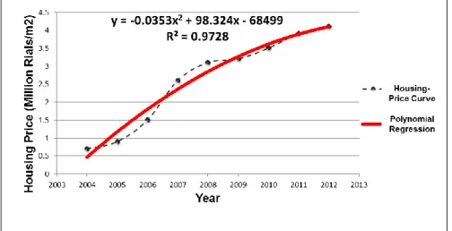
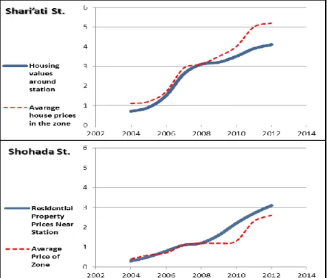
As mentioned earlier, in the present study to assess the impact of selected metro stations on the development rate of surrounding areas and also to understand its consequent qualitative changes, Housing Price Index (HPI) is analysed. In this regard, the average price of the residential properties (within a quarter-mile range of stations) has been collected over the period 2004-2012 (Table 1). The data are collected by means of semi- structured personal interviews with local residents who live in the surrounding neighbourhoods and also with the real estate agencies especially by reviewing their transactions and contracts. Furthermore, in order to authenticate the data, the official statistics are also maintained (Table 2). Comparing the data from the field survey and the official statistics certifies the accuracy and validity of the data collection process. At the end, in order to analyse the data, a proper method of Linear Regression is needed to show the effect of the metro stations' establishing on housing values, whether progressive or regressive. So by comparing the various methods of Linear Regression based on the target of the research and also regarding to this fact that the linear relationship between the independent variable (year) and dependent variable (Price) is a curved line, not a straight line, the Polynomial Regression with the second order is selected as the analysis tool. The analysis is performed by using Excel 2010.
Comparative analysis of the resulted equations and charts can compare the impact of metro stations on property values in two different parts of Tehran (rich and poor neighbourhoods). Subsequently, it can reveal the consequent effect of metro stations in reducing the spatial segregation in the city.
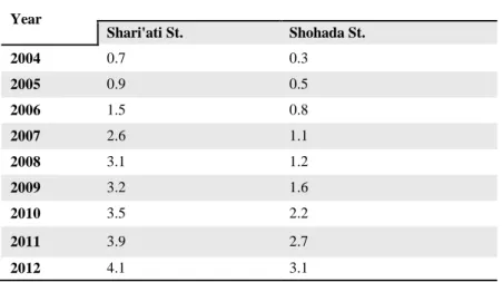
Table 1. Housing prices within a diameter of 1.4 miles from metro stations (Million Rials per square meters)
Year
Shari'ati St. Shohada St.
2004 0.7 0.3
2005 0.9 0.5
2006 1.5 0.8
2007 2.6 1.1
2008 3.1 1.2
2009 3.2 1.6
2010 3.5 2.2
2011 3.9 2.7
2012 4.1 3.1
Sources: A field study by authors as well as the data from the Management Information System of Real EstateTransactions of Iran.
Table 2. Official statistics on average housing prices (Million Rials per square meters).
Year
No.3
Zone
No.12 Zone
No.13 Zone
2004 1.1 0.4 0.4
2005 1.2 0.5 0.6
2006 1.7 0.6 0.8
2007 2.9 1 1.2
2008 3.1 1.1 1.3
2009 3.5 1.2 1.2
2010 4 1.3 1.4
2011 5 2.2 2.4
2012 5.2 2.6 2.7
Sources: The Ministry of Housing and Urban Development of Iran well as the Management Information System of Real Estate Transactions of Iran