of villages in Thailand and Laos along the lower Mekong basin : from the locals'
perspective
著者(英) Mostafa Khalili, Yan Chen, Chayadit Pumaneratkul
journal or
publication title
Journal for information, study and discussion of Global Resource Management, Doshisha
University
volume 5
page range 1‑19
year 2019‑03
権利(英) Organization for Advanced Research and Education, Doshisha University
URL http://doi.org/10.14988/00027519
Impacts of Dam Construction on the Livelihood of Villages in Thailand and Laos along the Lower Mekong Basin: From the Locals’ Perspective
Mostafa Khalili
1, Yan Chen
2, Chayadit Pumaneratkul
3Abstract:
This research presents the multi-dimensional impacts of dam construction, focusing on local people’s narratives and general field observations using the Mekong River as a case-study.
In recent years, several cascade dams have been constructed in the Upper Mekong Basin, in Yunnan province of China. In the Lower Basin, Xayaburi Dam is the first of a further eleven dams planned for construction in the near future. Due to the lack of comprehensive environmental and social impact assessment studies for any of the projects, the livelihood and food security of a large population living along the transnational Mekong River have largely been neglected.
Using a qualitative approach, this research is a small step towards highlighting the significance of the locals’
perspective as an important factor in the process of development planning. The way locals understand and analyze the socio-economic and environmental impacts of these dams on the rural livelihood is of interest to this research.
The fieldwork was conducted at two rural sites along the Thai-Lao border near Vientiane and Nong Khai cities to comparatively analyze the perception of local communities on the environmental changes in the Lower Mekong Basin. A total of 25 interviews were conducted together with the observation of social life in both countries. The results show that Laotian villagers felt the changes in fishery and sediment much more than their counterparts in Thailand. Since they still rely on the traditional ways of fishery and fish is the primary source of food for many of them, they are more vulnerable than the Thai communities.
Moreover, the interviews indicate that while many of the Thai villagers blame the Chinese dams for the recent changes, Laotians believe that the construction of the Xayaburi Dam is the main reason. Moreover, it was observed that Laotians are less inclined to talk about the issue. This confirms the multidimensional nature of development planning when environmental observations alone should not be the only basis for decision making.
Two environmentally similar but socio-politically different regions can be affected in dramatically different ways, as exemplified in this case study.
Keywords: dam construction impacts, Lower Mekong Basin, rural livelihood, social resistance
Table of Contents I. Introduction
II. Research Methodology III. Background of the Study IV. Literature Review
V. Transboundary Impacts of the Dams on Rural Livelihood VI. Conclusion
1 Graduate School of Global Studies, Doshisha University, Kyoto, Japan 2 Graduate School of Global Studies, Doshisha University, Kyoto, Japan
3 Graduate School of Science and Engineering, Doshisha University, Kyoto, Japan
Ⅰ. Introduction
This project portrays local perceptions of the multiple impacts of mainstream dam construction on the socio- economic and environmental situations. Against the background of a lack of independent and comprehensive feasibility studies, the primary objective of this research is to contribute, however small, to the development of strategies for the sustainable development of water resources including the locals’ perspective in countries located in the Mekong Delta.
Having a social perspective, this project investigates how the local people’s lives have been affected as a result of the environmental changes in the Lower Mekong Basin through assessing their awareness about the adverse impacts of dam construction and their strategies to cope with the consequences. In addition to the literature review, we adopted a qualitative approach by conducting semi-structured interviews mainly with the head of households whose income directly depends on the Mekong River, as well as with some officials, NGOs and community leaders. Two major cities along the Mekong River - Vientiane, the capital of Laos, and Nong Khai, the largest city across the Mekong in Thailand - were selected as the target cities for our research. The justification for selecting these cities was to compare the impacts in two countries under different political and social situations, but having the same environmental issues. The main research question of the project is as follows:
- What factors explain the main differences between the Thai and Lao people’s approach regarding their perception about the recent environmental changes?
While economic and political interests seem to be the main factors driving countries to construct dams regardless of their impacts on the environment and communities, this project endeavors to show the adverse impacts of constructing cascade dams on the Mekong River prioritizing the locals’ perception. While Xayaburi Dam in Laos is already under construction, three other large dams are to be constructed between Xayaburi Dam and the target cities of this project. Therefore, there is a vital need for the cooperation of social scientists, engineers and politicians to minimize possible negative impacts on the environment as well as the livelihood of the vulnerable population.
As a potential threat to the large population living in the Lower Mekong Basin in four different countries, this project aims to meet the objectives of the Global Resource Management Program at Doshisha University, by engaging researchers from different disciplines of social science and engineering. As no comprehensive research has been undertaken by major investors of the donors such as ADB, WB, UNDP or the Asia Foundation, we hope this research will add a different angle to the existing literature.
Following this introduction, the second chapter discusses the research methodology as well as the team’s limitations in conducting fieldwork in different parts. The third chapter provides a general background required for this research. After an introduction to the significance of the Mekong River to the livelihood of the region and the upstream dams, the debates on the construction of Xayaburi Dam are discussed. Then, changes in the environment, sediments and the fish volume are discussed from an objective point of view in the literature review part. Next, the results of the fieldwork in assessing the transboundary impacts on the villagers in the Lower Mekong Basin along the Thai and Laos border are presented. In the concluding remarks, the differences in the perceptions of villagers in Thailand and Laos regarding the reasons for the recent changes are documented.
Ⅱ. Research Methodology
Taking an interdisciplinary qualitative approach, our team consists of three Ph.D. students from different academic backgrounds (one from Science and Engineering, two from Global Studies, with one of the latter having an Engineering background), and a supervisor who is an expert on earth system science.
Prior to the fieldwork, a literature review was conducted on the topic, primarily to gather information on the environmental changes from a scientific viewpoint. To that end, some scholars, representatives of major organizations and several active NGOs were contacted to gain insight into the environmental and socio- economic impact of the dams in the Mekong region. The organizations included the Mekong River Committee, International Rivers (HQ in the U.S., branch office in Bangkok), Department of Water Resource Engineering, Kasetsart University (Thailand) and Watch the Mekong (Japan and Thailand). No reply from the Mekong River Committee was received; however, an interview was held in Bangkok with the Southeast Asia Program Director of International Rivers. Moreover, meetings with Professors from Kasetsart University in Bangkok and some experts in different disciplines from Doshisha University, Kyoto, Japan, were held to acquire knowledge on the relevant fields.
Two areas around 400 kilometers downstream from the Xayaburi Dam were selected as the research field.
The first was located in the suburban region of Nong Khai city, Thailand.
In addition to our observations of villagers’ daily lives, the infrastructures in the region and ordinary talks with the locals, we conducted in total 11 individual interviews with the head of households and one group interview with three families in the villages on the Thai side. The questions included basic attributes of the interviewees and their families, such as age, year of schooling, number of households, the occupation of each family member, the source of income and food, their livelihood dependency on the Mekong River and their resistance strategies. Semi-structured interviews were conducted and open-ended questions were asked on the changes that had happened in the years since the construction of the Xayaburi Dam. The interviews were conducted in the Thai language and were translated into English by the Thai-speaking member of the team. All the interviews were recorded and carefully transcribed.
Furthermore, 13 interviews were conducted in the same way on the other side of the Mekong River bank in Vientiane, Laos. Following the local leaders, interviewees were selected randomly from fishermen who fished on the river bank, or whose house was close to the river. A very similar questionnaire was used to conduct the interviews.
To obtain official permission to conduct the research in Laos, an official request was submitted to the National University of Laos. The team obtained permission from the Lao government to conduct the research;
however, a request for assistance from the National University of Laos was rejected as there was no academic cooperation between the universities. Thus, the interviews in Laos were all conducted with the help of some officials, with personal connections to the group, who asked that their identity be kept confidential.
As the political situation in Thailand and Laos is very different, restrictions on performing the fieldwork were distinct. Our contacts with a few NGOs in Laos failed to get any response. We asked the NGOs in Thailand to connect us with their counterparts in Laos; however, they rejected such request for political reasons. Few officials whom we met were not directly working on the focal issues of our research. Failure to get a response from the officials in charge, the small number of interviewees and the political restrictions were our main limitations in conducting the research.
Ⅲ. Background to the Study
In this part, first, we will present a general overview of the Mekong River in order to better understand the importance of the river to the people and countries in the region both from the environmental and socio-economic viewpoint. After that, information about several dams that have been operational, planned or under construction is reviewed. The dams are divided into two parts of the Upper Mekong Basin (in China) and the lower Mekong Basin (in Laos and Cambodia). The last part is dedicated to Xayaburi Dam, the first dam under construction in the Lower Mekong Basin. Since the fieldwork for this study was conducted close to this dam, understanding the operational and legal process of its construction was crucial for this research.
A. General Overview of the Mekong River
The Mekong River is one of the longest transboundary rivers in Asia. It is about 4,350 km long, servicing more than 810,000 km2 of land. The upper reach of the Mekong River rises as the Zhaqu River on the Tibetan Plateau in Qinghai province, China and flows through the Tibetan Autonomous Region and then through Yunnan Province as the Lancang River until it arrives at the meeting point of the borders of Burma, Laos and China (1,955 km). The lower Mekong Basin downstream of the Chinese border comprises the majority of the land area of Lao PDR and Cambodia, the northern and northeast regions of Thailand and the Mekong Delta and Central Highland regions of Vietnam (2,390 km).
About 60 million people live in the Lower Mekong Basin, according to national population statistics of the four LMB countries, about 85% of which live in rural areas (Landscan data 2007). Most of them live near rivers, lakes and wetlands, with 25 million living within a 15 km corridor either side of the Mekong mainstream (Landscan data 2007). A total of 53% of the Lao population and 4% of the Thai population are distributed within this corridor and 79% of the 15 km corridor population live within 5 km of the mainstream.
The biodiversity of the Mekong River and its tributaries has supported water resource-based rural livelihoods in this region for generations (Mollot et al. 2003; Meusch et al. 2003). Farming, fishing and the collection of other
aquatic animals and plants comprise the main livelihood activities and sources of food and cash income. In Lao PDR, more than 70% of rural households depend on fishing to varying degrees for subsistence livelihoods and additional cash income.
The high degree of dependence of the population on water resources for livelihoods and food security implies a high vulnerability to declining availability, quality and diversity of the resources. The uneven distribution of the population and varied degree of dependence suggest a disparity in the distribution of impacts of changes in the resources across national, social and ecological boundaries and social groups.
At Siphandone, on the Lao mainstream, just under 40% of households receive some income from fish, far more than in Thailand or Vietnam, where less than 10% of households obtain income from this source. The way people engage in fishery differs according to their wealth: to fish in the main rivers often requires a considerable investment in boats, motors and nets, while in habitats like flooded forests, wetlands and streams, more impoverished people can use simple gear to collect fish and other aquatic organisms such as frogs, snails and insects (Mollot et al. 2003).
B. Dams on the Mainstream of the Mekong River
Scientists usually divide the study of environmental issues concerning the Mekong River into two parts of the Upper and Lower Basin. Following this tradition, we will present an overview of different operational and under-construction projects in both parts.
Since 1993, the projects of constructing cascade dams on the Upper Mekong Basin have commenced.
With the last phase of the Nuozhadu Hydropower Plant commissioned in 2014, the installed capacity in Yunnan Province of China, i.e., the Upper Mekong Basin, totaled 15.4 GW for six dams (See Table 1). The Ganlanba project will be operated as a regulation reservoir to smooth the release of discharge to the downstream, which as of now is being performed by the Jinghong project. Detailed information about the installed capacity and commissioning of the Mengsong project is not available yet.
While Table 1 only includes the major hydroelectric projects in Yunnan Province, China has developed other in the upper reach of the Lancang River (upper half of the Mekong River). Moreover, seven projects in Yunnan Province are under construction with a total installed capacity of 960 MW. Another seven projects located in the Tibet Autonomous Region will add 630 MW to the Lancang hydropower when they are completed in 2030.
In the Lower Basin, since there are several countries directly or indirectly involved in the development process of the dams, some international cooperation has been initiated in the region. Cambodia, Laos, Thailand and Vietnam created the Mekong River Commission (MRC) to develop the Lower Mekong Basin in 1995. In addition to the Mekong River Commission, there are four major Mekong regional cooperation frameworks
Figure1. Dams on the Mekong River CGIARS / Internationalrivers.org
Table 1. Mainstream Hydropower Schemes in the Upper Mekong Basin (Lancang River, YunnanProvince, China)
launched and supported by an international organization and three great powers to strengthen regional cooperation, bring economic growth, social change and political stability in this region. The Greater Mekong Sub-region was created by the Asian Development Bank in 1992, the Lower Mekong Initiative was formed by the United States in July 2009; the Mekong-Japan Summit was organized by Japan in November 2009 and the Lancang-Mekong River Cooperation Mechanism was led by China in March 2016. A cooperative activity named Joint Research on the Hydrological Impacts of the Lancang Hydropower Cascade on Downstream Extreme Events has started between the MRC and the Lancang-Mekong Cooperation Mechanism (MRC, 2009).
The hydropower development in the Lower Mekong Basin has just started. As Table 2 shows, there are at least 11 planned hydro-electric projects in the mainstream Mekong, nine in Lao PDR and two in Cambodia. The installed capacity will reach 11.335 GW after they are operational.
C. Construction of Xayaburi Dam
Xayaburi Dam is the first project in the Lower Mekong Basin, located approximately 30 km east of Xayaburi town in northern Laos and 80 km south of Luang Prabang city. The project was initiated in 2011 and is planned to be completed in 2019. As a run-of-river hydroelectric power plant, the total installed capacity is 1,285 MW, and annual energy production will be 7,370 GWh. A power purchase agreement has been signed between the Electricity Generating Authority of Thailand (EGAT) and Electricité du Laos (EdL).
The first plan to build a series of dams in the Lower Mekong Mainstream was first proposed in 1950.
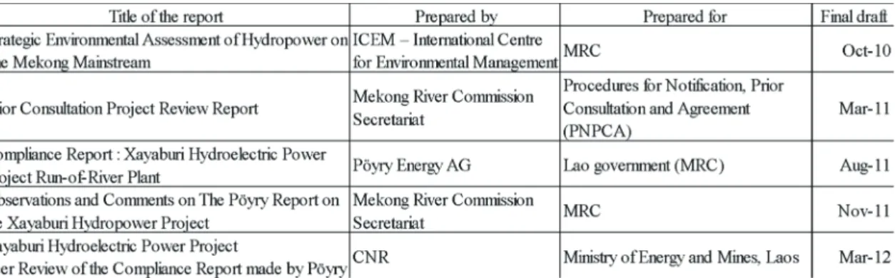
However, it took a long time until 1994 for the revival of the plans and the signing of the Mekong Agreement in 1995 to continue the process. After that, there was a longer delay in the progression until 2010 when the report by the Strategic Environmental Assessment of Hydropower in the Mekong Mainstream recommended a 10-year delay while further studies were carried out. This was the start of a series of arguments between a different independent organization to the Laotian government that have either slowed down or stopped the project (See Table 3).
In March 2011, the prior consultation project review report was prepared by the Mekong River Commission to study significant gaps and concerns identified in Laos’ documentation and recommended a further collection of baseline data and transboundary impact studies. However, discarding such studies, the government employed Pöyry Energy, a Finnish company, which later became the main contractor for the dam’s construction, to conduct
Table 3. Key studies on constructing the Xayaburi Dam
Table 3. Key studies on constructing the Xayaburi Dam
the Compliance Report. Pöyry’s report concluded that the project was “principally in compliance” with MRC standards despite identifying over 40 additional studies that were still required. The report, which obviously was not free of the conflict of interest, recommended that any additional studies could be conducted after construction was already under way. A few months later, in November 2011, the Mekong River Commission (MRC) objected to the Pöyry Report by preparing “Observations and Comments on the Xayaburi Hydropower Project.” The review concluded that the Xayaburi Dam would not fully comply with MRC standards even if all of Pöyry’s recommendations were followed. It also recommended that construction should be delayed to allow time for transboundary impact studies to take place. Although many scientists have criticized Pöyry’s findings, no one has stepped up to support them. In January 2012, the Lao government hired French company Compagnie Nationale du Rhône (CNR) to review Pöyry’s work after hearing the criticism from Cambodia and Vietnam. CNR focused on the issue of sediment flows and did not review Pöyry’s work on fisheries. However, CNR itself acknowledged that the report was only a “desk study” and further studies were required.
Despite all these hot debates, international and regional criticism had no influential impact on the Lao Government to stop or slow down the project. As seen in Figure 2, the construction process is under way mainly through the involvement of the Thai companies that are the main investors in the project.
IV. Literature Review
In this part, firstly, we will take a closer look at our two fields explaining how different they are when it comes to development planning and nation/state relations. Providing this information is important because socio- political differences between Laos and Thailand are the main variables of this research and the basis for building our arguments on. Later, due to the lack of reliable literature about the impacts on livelihood, we shall provide the reader with general information on the socio-economic impacts of dam construction in developing countries and the possible negative/positive impacts of these types of projects. This is to compensate for the lack of response by the government concerned as well as constructors who didn't give us any specific information on this particular project. Next, we will review some of the existing reports on the different impacts of dam construction in the Mekong region: the impacts on fishery and fish species which are closely connected to the livelihood of the rural population along the river, as well as the impacts of sediment trapping and water discharge of the dams. Most of the existing research has focused on the impact of the dams in the Upper Mekong Basin, partly because they are much bigger in size and were commissioned earlier, comparatively. (MRC 2015). In these reports, a wide range of relevant impacts has been discussed, including the change of water discharge, sediment load, fish species, water temperature, etc. According to the State of the Basin Report published by the Mekong River Commission in 2010, changes have taken place in water-related resources in the Lower Mekong Basin since 2005. Almost one in six households has members who have changed occupation because of declining productivity and services of the aquatic ecosystems. The data suggest that the impacts of changes in resources (caused by a wide variety of factors) have already been felt at all the study sites. Despite all these adverse impacts on the livelihood, especially in the poor rural areas, there is a scarcity of research about the socio-economic impacts in different countries. Most of the countries in the region have placed political restrictions on giving official permission to conduct independent research to access the social and economic impacts.
A. Development Planning and Nation/State Relations: Laos and Thailand
Divided by the great Mekong River, the people in both nations share linguistic and cultural similarities. In Figure 2. The Xayaburi Dam, as seen from above in early 2017 (Thien Y, The Mekong Eye)
fact, the Lao kingdom of Lan Xeng included all of northeastern Thailand as recently as the early 18th century (Ward 2016); however, nowadays, there is a huge difference between governance and nation/state relations in these two countries. Laos is a one-party state in which the ruling Lao People's Revolutionary Party (LPRP) dominates all aspects of politics and harshly restricts civil liberties. There is no organized opposition and no truly independent civil society. News coverage of the country is limited by the remoteness of some areas, repression of domestic media and the opaque nature of the regime. Economic development has led to a rising tide of disputes over land and environmental issues, which frequently lead to violence. Thailand, on the other hand, is governed by a constitutional monarchy. The King is the Chief of State and the Monarchy is hereditary, nevertheless, the political system benefits from enormous popular respect and moral authority. Therefore, although it is not ranked as a free or democratic country, the economy is booming and there is much more freedom of expression compared to Laos ( House 2017). Interestingly, as will be shown later, these points were reflected in our interviews and group observations. In fact, it seems that the economic situation and civil rights practices are among the most important factors that have affected public opinion in the two separate communities located in environmentally similar regions
B. Dam Construction: Socio-economic Impacts
Large dams significantly impact humans worldwide. In this part, we provide a general picture of the social impacts brought by dam construction, especially in developing countries. Wang et al. (2013) have categorized these social impacts into agricultural, economic and local culture.
1- Impacts on Agriculture
The most direct and important impact of dam construction is the inundation of farmland. The conditions of the land along riverbanks are generally ideal for labor-intensive agriculture. For example, most of the highly productive paddy fields are along riversides. As a consequence of farmland inundation, new farmland needs to be cleared to compensate for the losses incurred by local farmers. These changes cause lower productivity, due to difficulties in irrigation, increased soil erosion and increased pollution due to the usage of synthetic fertilizer to counteract the poorer conditions (Wang et al. 2013).
2- Impacts on Local Livelihood
Large dam projects may cause thousands of people to be relocated, and therefore have substantial impacts on local livelihoods. According to the World Commission on Dams (World Commission 2000), around 40–80 million people were relocated worldwide between 1950 and 2000 because of large dam construction. The direct impacts of large dams on local people include the loss of housing, farms and other resources. The relocated people are sometimes given new houses and newly cleared farmland. Indirect impacts include losing their jobs and social network, plus the possibility of psychological problems which have occurred in some cases, including some communities along the Upper-Mekong River (Zhao et al. 2012). To sum up, we summarize the debates raised by the proponents/opponents of dam construction. Proponents of the dam construction believe that it will generate opportunities for economic and social development. Some of their arguments include:
1. Dam construction projects will increase the employment opportunities for local people and boost the economy of the region.
2. New roads and bridges will be built in the process of dam construction that will enhance the quality of life and work.
3. Hydropower dams generate cheaper and cleaner electricity. Cheap electricity could reduce the costs of many industries and stimulate the local economy. (Wang et al. 2013, p. 17)
However, the other side of the debate argues that many dams actually fail to achieve their economic goals and even cause secondary costs to the environment and local communities. Some of their arguments are listed below:
1. Many large dams that are considered economically feasible actually end up failing to recover their total costs due to underestimating the technical difficulties.
2. According to the WCD’s report (2000), most of the irrigation dams and water supply dams fail to achieve
their designed goals, while hydropower is more likely to fulfill their goals. However, even in the case of hydropower, undesirable results may occur: Nam Theun 2 Dam in Laos promoted by the World Bank, constructed for the development of hydropower projects, has displaced thousands of people and killed at least 40 (Boyle 2018).
3. Most large dam projects do not consider the externalized social and environmental costs when determining their total costs; For example, large dams could harm a downstream fishery that is not calculated as a cost.
4. There exist many alternatives to large dams, such as water-saving agricultural techniques that have great potential for reducing the agricultural water demand. If the use of renewable energy were increased greatly, the need to construct hydropower dams might decline substantially. (Wang 2013, p. 18)
C. Review of the Impacts on Fishery and Fish Species
The operation of hydroelectric power plants in the mainstream of the Mekong River has already changed the living conditions of fish by changing the water flow, sediment load and nutrients. Meanwhile, several dams have blocked the passage of migratory fish species affecting their reproduction processes, which will further affect the livelihood of residents along the river.
Several studies discuss the possible impact on the fish species and livelihood depends on it, but the lack of reliable data of the species composition of the catch in the Lower Mekong Basin has restricted the arguments.
Barlow et al. (2008) mentioned that not all fish species caught in the basin are at risk from mainstream dams. They argue that those fish with only limited migrations over short ranges may not be affected. Some of the species are highly adaptable to habitat modification including impoundment. Moreover, they pointed out that species which
“undertake significant passive and active migrations along the mainstream between critical spawning, feeding and refuge habitats as part of their life histories” are most likely to be affected. They continued to estimate the size of migratory fish resources in the Lower Mekong Basin by adopting a three-pronged approach. The first was a survey of 13 fisheries scientists from Laos, Cambodia and international organizations operating in the Lower Mekong Basin. The combined results from the group indicated that migratory fish resources comprise 71% of the fisheries yield in the Lower Basin. The first sale value of migratory fish at the time of the survey (2007) was estimated to be US$1.89 per kilogram. In the second step, they estimated the amount of highly migratory fish species in the basin by literature review. They divided the lower Basin into three major migration systems: the Lower Mekong Migration system (Vietnam to Khone Falls), the Middle Mekong Migration System (Khone Falls to Vientiane) and the Upper Mekong Migration System (Vientiane to China). By adding up the annual yield in each system based on the statistics of each country, the annual yield totaled 1,270,000 – 1,570,000 tons. The third step was to combine the information of fish migration with the catch survey data. As a result, 58 fish species were categorized as highly vulnerable groups, which comprised 38.5% of the total weight of all 233 species in a 2003/04 fishery catch survey.
By applying this proportion to the total fish yield of 1,860,000 tons in the Lower Mekong Basin (Hortle 2007), the annual yield of highly vulnerable migratory fish groups is approximately 744,000 tons, which will be equal to 1,400 million dollars if using the first-sale price estimated in the first step.
D. Review of the Sediment Concentration Impact
The studies on sediment decrease in the Mekong River are limited to the impacts on the Upper Mekong Basin. Although the sediment trapping impacts could be measurable after the construction of planned dams in the Lower Basin, the study of the current situation based on the impacts of the existing dams could be of help in predicting the impacts of the upcoming dams.
With the first four dams in operation, the downstream effects of the Lancang–Mekong cascade have become increasingly apparent. Water level fluctuations are now discernible in the dry season between Chang Saen city in Thailand and Luang Prabang in Lao PDR. Mekong River Commission modeling studies show that the primary effects on the flow regime in the lower mainstream include lower flood flows in the wet season and a shift in the time of the peak flood, and higher river flows in the dry season.
Apart from the issues associated with changes in flow regulation, the combined effect of sediment trapping in reservoirs in the Lancang–Mekong cascade and sediment trapping by the reservoirs of tributary dams in the lower basin requires careful assessment (MRC 2010, p. 72). It is estimated that the completed Yunnan cascade will trap some 90% of the upper Mekong sediment contribution to the lower basin (Kummu and Varis 2007).
MRC (2010) estimates that as much as 40–50% of the Mekong River’s sediment originates in China.
Analyses of sediment flux at various gauging stations on the Lower Mekong River have indicated a sharp decrease in the total suspended solids concentration (SSC) in the Mekong River in the post-dam period. Kummu et al. (2007) specified the period as after the closure of the Manwan Dam in China in 1993, the first one of a planned cascade of eight dams after its reservoir was infilled in 1992. Given that the estimation of sediment flux is challenging since the measurements of SSC were sporadic, Lu and Siew (2006) continue to state that the areas along the upper-middle and lowermost reaches of the Mekong have experienced a decline in sediment flux.
However, it remains vague in their study whether that is the result of sedimentation in the Manwan Dam, or the decrease is only statistically significant at the nearest evaluating station below the Dam (i.e. Chiang Saen). At the same time, sediment fluxes in areas located in the mid-reach of the river have remained stable or even increased.
In another study, Fu et al. (2006) analyzed the sediment concentration at Jinghong, which is about 400km downstream of the Manwan Dam and 314km downstream of Dachaoshan Dam. They concluded that the
“completion of the two dams had caused a significant and continuous reduction in annual sediment concentration by 50% since the late 1980s.” The much larger Xiaowan Dam, located upstream of the Manwan Dam, has a predicted trap efficiency of 90% (Guo et al. 2007) and will reduce the sediment concentration to less than 10% of its natural value after passing the Dachaoshan Dam (Walling 2009). MRC (2010) forecasted that the sediment load would be reduced even further after the construction of the remaining dams of the cascade. Wang et al. (2011)’s findings are in line with MRC (2010) and they added that “usually, sediment load increases due to soil disturbance occur only during the construction period of dams, as observed from 1986 to 1992 during Manwan construction.”
The reduction in sediment concentration will likely have significant implications for the ecosystem of downstream countries.
E. The Impact of Water Discharge
The annual flood pulse is the key driver for the ecological productivity in the Mekong Basin (MRC 2010). It is shaped by the seasonal monsoon climate, with a distinct low flow season (dry season) in December-May and a high flow season (wet season) in June-November (MRC 2005).
Laos is the main water source of the Mekong. Regarding the Mekong’s annual water discharge, 82%
comes from four sources: “(1) the mountains of northern Laos through a number of tributaries; (2) the Southern Mountains via the San, Kong and Srepok; (3) the Mun Chi System, draining a large part of the Korat Upland; and (4) the drainage outflow from the Tonle Sap” (Gupta 2009). The rest originates in China (18% before any dams were built according to Gupta 2009, 16% according to Adamson et al. 2009) and Myanmar (2%, Adamson et al.
2009), although the runoff from China contributes to over 35% in April and May (Kummu et al. 2007).
Studies on the impact of the Upper Mekong Basin dams on the water discharge in the Lower Basin have been conducted since the 1990s, immediately after the first dam was constructed in China’s Yunnan province. Kuenzer et al. (2013) did a comprehensive review of the existing literature on this issue. While most of the primitive studies have focused on the Manwan Dam (Lu et al. 2008; Lu et al. 2006), the recent ones (Räsänen et al. 2012; MRC 2010) examined the dam impacts of the Yunnan cascade. The results indicated that the discharge increases in the dry season and decreases in the wet season, though at different magnitudes. Kuenzer et al. (2013) summarized that “Independent of the source, all authors underline the occurrence of a shift in flood pulse and a decrease in its duration and amplitude, while dry season variability is likely to increase.” Despite the numerous studies, it has to be noted that the lack of publicly available data on the reservoir operations and water releases from the hydropower reservoirs in the Upper Mekong Basin has made it difficult to assess the impacts more accurately and objectively.
The latest study on this topic has been conducted by Räsänen et al. (2017). Using the water level data and discharge conversions over the period of 1960–2014 provided by the Mekong River Commission Secretariat, the findings indicate that the hydropower operations have considerably modified the river discharges since 2011.
The authors conclude that general changes in water discharge were characterized by an increase in dry season discharges and a decrease in wet season discharges, along with large and rapid discharge fluctuations in the dry season. The most significant changes were observed in 2014 after the completion of the Nuozhadu Dam, the most massive hydropower project in the entire Mekong Basin. The discharge impacts are expected to vary from year to year depending on hydropower operations, and the impact observed in the relatively lower reach of the downstream turned out to be weaker.
By reviewing the environmental consequences of building dams in the mainstream of Lancang-Mekong River, Chinese authorities from the Asian International Rivers Center argue that most of the impacts of the Upper Mekong Basin dams are limited to the Chinese border; they have only had small unfavorable effects on downstream environments and ecosystems outside of China (Fan, He and Wang 2015). Similarly, Li, He and Feng (2011) from the same organization state that significant downstream impacts of the two operating dams of Manwan and Dachaoshan are limited in scale to diurnal changes, primarily in the narrow channel north of Vientiane.
Despite their differing opinions, most independent researchers suggest that considering the potential environmental, socio-economic and humanity risks of the mainstream dams, transboundary cooperation for managing the downstream impacts is urgently required to ensure sustainable development in the Lancang-Mekong River Basin (Fan, He and Wang 2015).
V. Transboundary Impacts of the Dams on the Rural Livelihood
To assess the transboundary impacts of the dams on the lower basin, we focused on the rural areas near two large cities located about 400 kilometers away from the Xayaburi Dam across the Thai-Lao border. The main reason for selecting these regions was to have easier access to the villages considering the limitations of the current study.
Unless in the region close to the Thai-Lao Friendship Bridge, the economy of the villagers on either side is not dependent on the border trading. Villagers across the border speak the same language and historically maintain some family ties on the other side. On some occasions, illegal crossing of the river border to participate in events such as funeral and wedding ceremonies is a common occurrence.
Our target villages on the Thai side were located in the eastern suburbs of Nong Khai city as marked on the map (Figure 3 – Location No.1). On the Laos side, the fieldwork was conducted in two different regions, marked on the map as Location Nos. 2 and 3. Location No.3 refers to some small towns attached to Vientiane city and Location No.2 points to several villages close to Nong Khai city across the river.
Based on our fieldwork, the infrastructural developments on the two sides were completely different. The roads of all Thai villages in the site were paved, and long walking paths have been built along the river. All villages had access to electricity and piped water. The local economy relies on rice production and fish farms.
Temples, schools and health centers were mostly well-distributed with new buildings, and local government activities to support the villagers were relatively satisfactory according to our interviews.
The villages on the Laos side, on the other hand, lack fundamental infrastructure and the villagers were impoverished, comparatively. Many families could not afford the schooling costs for their children beyond secondary school. They maintained their local culture and traditional lifestyle to a great extent.
The main criteria for selecting interviewees was their income’s direct dependency on the Mekong River like fishermen, fish merchants, farmers, etc. From each occupation, we tried to maintain the balance of economic class.
Eleven individual interviews in total were conducted with the head of households together with a group interview with three families in the villages on the Thai side. In Laos, we conducted six interviews at Location 3 and seven others at Location 2 were conducted. The surveys were conducted as open ended semi-structured interviews using a three-pronged approach:
First, we asked about the family life, income, social and economic class and their livelihood dependency on the Mekong River. Second, the recent changes in water level, sediments, fish species and fish volume were asked in detail. Third, they were asked about their perception on the reasons behind such changes, their information sources and their current and future strategies in confronting environmental changes of the Mekong.
Figure 3. Locations of the targeted villages in Thailand and Laos (Location 1 is on the Thai side and Locations 2 and 3 are in Laos)
A. Evaluating the Impacts on Villagers on the Thai Side
The income source of villagers on the Thailand side consists of a combination of fishery, rice plantation and keeping livestock such as cows and pigs. Investing in different income sources helps them to reduce the risk of income loss caused by environmental disasters. Villagers whose houses are located next to the river set up a certain number of caged fish farms to rear baby fish in the river. Moreover, there are plenty of rice fields in the region.
In this section, first, a general overview of the selected villages on the Thai side is given. Then, we focus on the impacts of the changes in water level on the caged fish farms. According to our fieldwork, one of the main reasons that villagers lose a lot of fish is the abrupt changes in water level and temperature. This happens a couple of times a year when Chinese dams are discharged. Finally, locals’ perceptions on the possible impacts of upstream dams are investigated. The interview results show that the locals have not felt any significant changes since Xayaburi Dam has been under construction. They believe that the Chinese dams are responsible for their fish loss.
1. General Overview of the Field
The fieldwork on the Thai side was conducted in the villages along the Mekong on the eastern side of Nong Khai city. Some of the villages in which we conducted our interviews are Sala Kaew ku, Wat Pho Chai and Ban Phan. Based on the information from the residents, each village has an average of 300 families.
As Figure 4 shows, there are plenty of rice fields in the region. Rice plantation is performed twice a year in the dry and rainy seasons. During the dry season, they use Mekong water which is available through canals constructed by the government. The rice farmers rent the canal water from the government on an hourly basis.
According to them, their production increases during the dry season as the Mekong water contains sediments that improve the rice fertility.
In recent years, the local government started a project to support local entrepreneurs from the villagers who engage in start-ups for community development. For instance, one of the interviewees, a 70-year-old woman, has just established a small fish drying unit by obtaining support from the local government. She was given land for her business beside the village's temple as well as some other necessary facilities to start her business. Such examples show the local government's endeavor to support villagers.
2. Community Perceptions on the Reasons for Recent Changes
According to the interviewees, it has been several years since anyone on the Thai side relied on traditional Figure 4. Villages on the east side of Nong Khai city
Location number (1)
Figure 5.(1) Sun drying of the paddy on the walkway along the river.(2) Product basket of a local entrepreneur
fishery as their main income source. While there are still a few people who do fish occasionally, it is neither considered as a significant portion of their income nor their daily food source. Instead, during the last ten years, the floating caged fish farming system has been initiated by some of the residents and later developed with the governmental and private sector’s support.
The decrease in the number of fish in the lower Mekong Basin in recent years together with the economic development of the country caused many villagers to establish some floating caged fish farms along the river.
According to the interviewees, fish farms are economically much more profitable than traditional fishery.
Floating cage fish farms are constructed using wooden or metal rods as the frame in various sizes of around 3(L) x 2(W) x 2(H) meters. As illustrated in Figure 4, the plastic water tanks keep the net cages floating on the water.
The owners need to put juvenile Nile tilapia fish inside each cage and feed them three times a day since there is little natural food available to the fish in the cage. While the initial construction cost for these cages is not very high, the feeding cost for the fish is considerably high. Moreover, the payback period of the invested capital is quite long. Therefore, not every family can afford the total cost by themselves. To overcome the shortage of capital, besides the availability of governmental loans, some chain companies offer wages for those who can rear fish for them.
While fish farming is far more profitable than traditional fishery on the Mekong, there are some risks for the farm owners. According to the fishermen, abrupt and unnatural changes in the water level and temperature cause the most significant fish loss in their fish farms. Such losses usually happen when some of the Chinese dams in the mainstream discharge water. Most of the fish cannot adapt to the rapid changes.
Since fish farming does not depend on the number of fish in the river, the villagers in Thailand did not express any changes in the volume of the fish or decrease in the species. On the other hand, all interviewees expressed their dissatisfaction about the Chinese dams already built in the Upper Basin's mainstream. When the Chinese dams are discharged in order to allow large commercial ships to cross the river, the most significant loss of fish happens in the lower basin. An experienced fisherman in Sala Kaew ku village expressed that:
“When the Chinese discharge the dam, the water level reaches 20 meters. Fish cannot bear the abrupt change in the water temperature. Therefore, we lose almost half of our fish in each cage.”
The news of the Chinese dam’s discharge very quickly spreads around the villages, and the fishermen prepare themselves to sell the dead fish as soon as possible, of course for less than half the price of the large mature ones.
According to the villagers, while they benefit from some governmental support during natural disasters such as the spread of disease among the fish or flooding, no form of governmental assistance is provided for the fish loss during the abrupt change of the water level.
In general, the middle-income fishermen were more aware of the adverse impacts of the mainstream dams on their life and income. Therefore, many of them blamed the Chinese for constructing the upstream dams and expressed their disagreement with the new dams planned for construction in the Lower Basin too. There were also a few low-income families among our interviewees who had never heard about the Xayaburi or other dams planned. An old woman from Wat Pho Chai village who owns a few fish farms expressed that:
Figure 6. Caged floating fish farms Figure 6. Caged floating fish farms
“… Chinese dams are already constructed and we have experienced the impact, I do not think that anything worse is going to happen in the future with more dams… so I do not care if they are building more and more…”
The information flow on the dam construction on the Thai side was mainly formed by the Thai governmental media. While freedom of the press in Thailand is not guaranteed by the government, the media broadcasted the construction of Xayaburi Dam as a case of international aid and foreign investment in Laos (Reuters 2014). On the other hand, NGOs tried to form some campaigns among the local villagers; however, because of their political and budget restrictions, they were not very successful. None of the families whom we interviewed engaged in any social action against the construction of the Xayaburi Dam. Many of them had not even heard about such campaigns. This situation was quite shocking for us as there are many online reports about some large campaigns in cities and villages along the river.
B. Evaluating the Impacts on Villages on the Lao PDR Side
For centuries, the exceptional biodiversity of the Mekong River, directly or indirectly, has been the primary source of income for millions of locals that live on the river bank. However, the direct dependency on traditional fishery varies according to the countries’ development. Laos, as one of the lowest-income countries in the region, economically depends on the river, comparatively.
Among the communities living along the river, at least one member from each family goes to the river every day to catch some fish for their daily meal. Based on our interviews, the local people mentioned two significant changes in the recent year that have affected their economy: Significant decrease in their catchment amount and the changes in the sediments. In this part, after a general introduction of the field, we will explain the impact of the decrease in fish catchment on the villagers’ life. Then we will discuss the community’s awareness of the impacts of dam construction and their perceptions on the reason for the recent changes.
1. General Overview of the Field
The fieldwork on the Laos side of the riverbank was conducted in two different locations as marked in Figure 3. Location 3 (See Figure 7), Oumong neighborhood, is a suburb of Vientiane city close to the international airport, where there used to be a small village which has since been attached to the city by its expansion.
The rapid growth in the tourism industry has heavily influenced the economy of the surrounding villages in this region. Although the access roads on the river bank have not been paved and there are many potholes along the way, the hotel industries have been expanding rapidly along the river. (See Figure 8).
These rapid changes in the city together with the decrease in fish catchment have shifted the economy of these suburb residents gradually from being directly dependent on fishery or growing rice to a labor force involved in the emerging tourism industry such as that of the construction or service sectors.
The next location to conduct fieldwork for this study was some villages along the river from the Thai-Laos friendship bridge to the East (See Figure 9). Our initial aim was to focus on the villages facing those we studied Figure 7. Suburbs of Vientiane city, near the international airport.
Location number (3)
Figure 8. Unpaved roads and the growth of the tourism industry in suburbs of Vientiane.
on the Thai side. However, the unpaved roads restricted our access to those areas. Instead, we managed to conduct the fieldwork in villages facing Nong-Khai city. Generally, the area on the Laos side is less populated compared to Thailand and the villagers who are living beside the river usually do not own the rice fields. As this area is quite far from Vientiane city (about 30 kilometers of unpaved road) and daily commuting is difficult, a large number of families still rely on fishery as the primary and only income source.
The main income source for other villagers far from the river bank is rice cultivation. The government has built some large water canals to carry the water from the river to the rice fields, and the villagers pay for the local government to use this canal water, especially during the dry season.
2. Community Perceptions on the Reasons for Recent Changes
Unlike the Thai side, the governmental media in Laos does not hold much attraction for Laotians. They mainly watch the entertainment TV channels from the Thai side. However, for the news, they follow both the Laotian and Thai side channels. As in Laos, there was large propaganda in governmental discourse about the importance of the Xayaburi Dam for their development, people were well-aware of the construction process.
Many Laotian villagers still use traditional catchment methods for the fishery, whether as an income source or for their daily food. For this reason, unlike the Thai side, Laotian villagers felt a significant decrease in fish volume in recent years.
According to them, the government prohibited setting up the fish farms along the river several years ago. For this reason, some families moved to the other tributaries nearby where fish farming is still allowed. We could not obtain any official reason for this prohibition.
The economic dependency on fishery was quite different for the villagers in Locations 2 and 3. Located in the suburb of Vientiane city, villages in Location 3 were less dependent on fishery as their income source. Instead, they are generally engaged in the tourism industry or being considered as the labor force for the rapidly growing economy of the capital city. On the other hand, in Location 2, there are still many families whose only income source is fishery.
In Oumong village (Location 3), about 30 out of 200 families still engage in traditional fishery as their main income source. They own boats and can use the fish nets as the catchment tool. On the other hand, other families go fishing for a few hours every day to catch a small number of fish for their daily food.
All of the interviews at both sites did mention that the number of fish has significantly decreased especially in the last few years. They stated that nowadays it is very difficult to make a living just with fishery like they had been doing previously for many years. A 56-year-old man in Oumong village (Location 3) stated that:
Figure 9. Villages facing Nong Khai city on the side of the border in Laos Location number (2)
the local government to use this canal water, especially during the dry season.
Figure 10. 1- Unpaved roads, the dust and difficulties of access to the villages 2- A local grocery shop in Thadeua village
“I used to be a fisherman for more than 30 years. However, nowadays I cannot make enough to feed my family by fishery alone. I used to catch about 20-30 kilograms a day and it has been reduced to less than 3 kilograms. That is why now I have shifted to making and selling fish nets for those who own the boats and can go fishing on the river. My wife is also working as a beer delivery service with a motorcycle to the hotels and restaurants.”
According to the interviewees’ claim, the decrease in the catchment amount is about 80% to 90% only in the last few years. Because of this decrease in number, many fishermen on boats, taking the risk, cross the Laotian border into Thailand’s territory to increase their chance of catchment.
Moreover, another significant reason for the decrease in the catchment amount is the contraction in sediment level in some locations. This change has been felt differently by the fishermen in distinct locations according to the river flow speed and its depth. While interviewees in Location 3 reported on the decrease in sediment level, others in Location 2 did not feel any impact. The reason could be explained with the difference in the river depth. In Location 3, the river width is wider and the flow speed is slower. Therefore, the decrease in sediment level causes the fish nets to get snagged on the large rocks. This has made it very difficult for the fishermen to manage their fish nets in such locations.
As discussed in the previous parts, all the fishermen and community members claimed that the fish numbers had significantly decreased in the last 3-4 years; however, the answers to the question of the reasons behind it vary among different people. Some locals also reported that the water level fluctuation is no longer normal. When the level is high, they cannot go fishing.
Some of the interviewees in the remote villages were not aware of the construction of the Xayaburi Dam in the upper stream. They either have no idea about the reason behind the recent changes in the river or some claim that this phenomenon is because of the overfishing. On the other hand, those who live closer to the city or follow the news did know about the dams in China. Since the impact has only started to be felt by lower basin residents in recent years, many people have blamed the Xayaburi Dam as being the main reason behind the changes. A middle- aged man from Thadeua Village who used to be a fisherman but now runs a small grocery shop said that:
“The water level changed 3 to 4 years ago because of the Xayaburi Dam. The Chinese dams did not affect our lives that much. The main impact started once they started to construct the Xayaburi Dam.”
Even though some of them are well aware that Thai companies are the main investors of the project declaring that they are the victims of these rapid environmental changes, no collective action has been reported from the Laos side so far. While we were concerned about the political restrictions against any forms of social resistance, Laotians preferred not to express any personal objection to our group. A young man who owns a restaurant and three boats close to the Thai-Laos friendship bridge stated that:
Figure 11. (1) Professional fisherman catches a large Mekong catfish.
(2) The common usage of square fish nets to catch the daily food.
“Because of the Xayaburi Dam, the environment changed, everybody knows about it, but they cannot do anything. We follow the news on Thai TV, so we know about it.
Nevertheless, the government is making the decision. Our position is neither positive nor negative.”
This position of remaining neutral was seen among almost all of the interviewees. While a few villagers stated that they are happy about the dam, most of them mentioned that they are powerless and their voice cannot be heard for decision making. One interviewee who is a rice farmer and inherited a large rice field talked about how he was witnessing the demonstrations in Nong Khai city:
“It was a couple of years ago when I crossed the border to Nong Khai and saw some protesters against the Xayaburi Dam construction. Some groups were supporting the dam construction, while others were objecting to it; there were two groups wearing shirts in different colors: white and red. I think the locals did not inspire the movement, but there were some political parties that organized the people, bringing them onto the street.”
Many interviewees heard about the adverse impacts of dam construction on the environment and their life from Thai TV channels. The Laotian media, on the other hand, advertises the dam as a symbol of the start of rapid economic development and the starting phase of the country becoming the battery of south-east Asia.
All in all, there is a strong tendency among the locals to blame the Xayaburi Dam, not the Chinese dams, as the main reason for the changes of the fish volume in recent years. They, however, did not show open disagreement to stopping the construction process. In general, the contradiction of blaming the dam construction as the main reason for the problem and not expressing their ideas openly might be understood when considering the political restrictions on freedom of speech in Laos.
VI. Conclusion
There are few studies that focus on the environmental and socio-economic impact produced by the cascade dams on the Lower Mekong Basin. Most of the arguments rely on NGO / NPO information, which turned out to be lacking in empirical evidence, or sometimes biased to a different extent. Against the background of the scarcity of academic objective research, this project attempted to comparatively clarify some of the environmental and socio-economic basic facts based on fieldwork in the rural areas of Thailand and Laos.
The impact on the population living in the Lower Mekong Basin varies significantly among different regions.
In the case of this study, fishermen in Nong Khai who manage the caged floating fish farms along the river bank are more vulnerable to the sudden change in water level caused by discharges from Chinese dams in the Upper Mekong basin. On the other hand, using this fishery method frees them from worrying about the reduction of sediment in the riverbed. Across the river, however, fishermen in the suburbs of Vientiane city are still using traditional methods of fishery in the Mekong River. They are more sensitive to the change in sediment and fish amount, many of them declaring a significant decrease in both.
Moreover, the socio-economic and livelihood impact in each country differs as well. For instance, while on the Thai side only about 10% of the population were involved in fishery, in Laos, this proportion rose to nearly 40%. Furthermore, for many Laotian villagers, fish is the only source of protein in their daily meal. Therefore, such dependency on the river as the primary source of income and food security for many villagers in Laos shows how vulnerable the people are to any environmental changes in the Mekong.
While on the Thai side, people’s perception indicates no impact from the Xayaburi Dam, but from Chinese dams, Laotians blame the Xayaburi for being the main source of recent changes. From an objective viewpoint, as Xayaburi Dam is not operating yet, it cannot be the only reason for the recent changes. This shows that the perception of the locals profoundly depends on the local discourse. At the same time, any social movement is being carried out based on such perceptions rather than scientific research. This indicates the importance of studying the locals’ perception of environmental changes in addition to having a positivist and scientific viewpoint.
Considering people’s perception of the recent changes, the research shows that the Laotian villagers were
more conservative in participating in any collective actions against the construction of the Xayaburi Dam. The Thai communities were more expressive, although they did not feel the impact in their daily life as much as the others across the border did. Although this difference is considerably important, the role of NGOs and other international organizations seems to be far more vital in putting international and political pressure on authorities by mobilizing the local communities.
The governmental discourse in both countries was to support the construction of dams. While in Laos, the focus is on the need to expedite the development process by using the countries’ potential to become the “Battery of Asia” by transporting energy to the neighboring countries, the focus on Thai media is on the importance of foreign investment. In fact, becoming the “Battery of Asia” could be a good way of expediting the economic development; however, the social and environmental impacts should be carefully assessed and minimized before initiating any project.
While the environmental impact is almost the same for the targeted areas of this research, it seems that the economic situation and civil rights practices are among the most important factors that have affected public opinion in the two separate communities located in environmentally similar regions.
At least two limitations exist in this part of the research. First, the environmental impact could not be investigated thoroughly. Change of factors such as sediment has been widely discussed in the published literature, but most of that focused on the impact of Chinese dams in the upper stream of the Mekong River. This research encountered the same restriction as the previous studies did, i.e., the monitoring data along the Mekong River can hardly be accessed by the public. Meanwhile, people are taking sand from the river to sell as construction materials. Thus the decrease in sediment cannot be attributed merely to dam construction. Also, the Xayaburi Dam is still under construction, so probably some of the impacts can only be observed over time.
The second limitation is that the change in fish amount could not be discussed adequately. Similar to the sediment decreasing, it is reported in the field that the number of fishermen has increased in recent years. In this report, the responses of the fishermen have been discussed without comparing the statistics of total fish yield amount; attention has to be paid to the one-sided approach when interpreting the results.
As empirical research that covers the major aspects and takes the entire Mekong region into consideration, this project is a small step towards facilitating the countries involved to build a sustainable development strategic framework while sharing the prosperity. Since many other dams are still in line for construction, this project could be used in the pre-consultation studies for upcoming projects to mitigate the environmental as well as social problems. On the other hand, as the public needs a comprehensive understanding of what’s going on and what should be done to help to improve the situation, results from social investigations in this project might be used by some social and political intellectuals to measure the need for strengthening the civil society in the region.
Acknowledgement
We would like to thank the GRM program at Doshisha University, Kyoto, Japan, for providing the opportunity and financial support for this project. Moreover, our special appreciation and thanks go to Professor Akira Hayashida from the Graduate School of Science and Engineering at Doshisha University for supervising the project.
References:
Adamson, P.T., Rutherford, I.D., Murray, C.P. and Iwona, A.C. (2009). The hydrology of the Mekong River.
In: Campbell, I.C. (ed.) The Mekong. Biophysical Environment of an International River Basin. Elsevier, New York, pp. 53–76.
Alistair, R.C. (2015). Notification and consultation procedures under the Mekong Agreement: insights from the Xayaburi controversy. Asian Journal of International Law, 5(01): 143–175.
Chang, F.K. (2013). The Lower Mekong Initiative & US foreign policy in Southeast Asia: Energy, environment and power. Orbis, 57(2): 282–299.
Barlow, C., Baran, E., Halls, A.S. and Kshatriya, M. (2018). How much of the Mekong fish catch is at risk from mainstream dam development? Catch and Culture, 14(3), Retrieved on January 22, 2018 from https://www.
worldfishcenter.org/content/how-much-mekong-fish-catch-risk-mainstream-dam-development
Cosslett, T.L. and Cosslett, P.D. (2018). Mekong regional cooperation and development of water and rice
security. In: Sustainable Development of Rice and Water Resources in Mainland Southeast Asia and Mekong River Basin. Springer, Singapore.
Fan H., Daming H. and Hailong W., Environmental consequences of damming the mainstream Lancang-Mekong River: A review. Earth-Science Reviews, 146:77–91. doi:10.1016/j.earscirev.2015.03.007
Fu, K., He, D. and Li, S. (2006). Response of downstream sediment to water resource development in the mainstream of the Lancang River. Chin Sci Bull, 51: 119–126.
Guo, Q., Cao, W., Lu, C. and Lu, Q. (2007). Sedimentation of Dachaoshan reservoir in cascade hydroprojects on the Lancang River. In: Proceedings of the Tenth international Symposium on River Sedimentation, Vol. VI.
Moscow State University, Moscow, pp. 55–59.
Gupta, A. (2009). Geology and landforms of the Mekong Basin. In: Campbell, I.C. (ed.) The Mekong. Biophysical Environment of An International River Basin. Elsevier, New York, pp. 29–52.
Hogan, T.W., Cada, G.F. and Amaral, S.V. (2014). The status of environmentally enhanced hydropower turbines.
Fisheries, 39(4): 164–172.
Hortle, K.G. (2007). Consumption and the yield of fish and other aquatic animals from the Lower Mekong Basin.
MRC Technical Paper No. 16, Mekong River Commission, Vientiane. Lao PDR, pp. 87.
House, F. (2017). About Freedom in the World: An Annual Study of Political Rights and Civil Liberties. Freedom House, pp. 526–527.
Kummu, M. and Varis, O. (2007). Sediment-related impacts due to upstream reservoir trapping, the Lower Mekong River. Geomorphology, 85(3–4): 275–293. doi:10.1016/j.geomorph.2006.03.024
Li, J., Dong, S., Peng, M., Yang, Z., Liu, S., Li, X. and Zhao, C. (2013). Effects of damming on the biological integrity of fish assemblages in the mid Lancang-Mekong River basin. Ecological Indicators, 34: 94–102.
Li, Z., He, D. and Feng, Y. (2011). Regional hydropolitics of the transboundary impacts of the Lancang cascade dams. Water International, 36(3): 328–339. doi:10.1080/02508060.2011.585447
Lu, X.X. and Siew, R.Y. (2006). Water discharge and sediment flux changes over the past decades in the Lower Mekong River: possible impacts of the Chinese dams. Hydrology and Earth System Sciences, 10(2): 181–
195. doi:10.5194/hess-10-181-2006
Lu, X., Wang, J. and Grundy-Warr, C. (2008). Are the Chinese dams to be blamed for the lower water levels in the lower Mekong? In: Kummu, M., Keskinen, M. and Vairs, O. (eds) Modern Myths of the Mekong. A Critical Review of Water and Development Concepts, Principles and Policies. Water & Development Publications, Helsinki University of Technology, Helsinki, pp. 39–54.
Kummu, M. and Varis, O. (2007). Sediment-related impacts due to upstream reservoir trapping, the Lower Mekong River. Geomorphology, 85. Elsevier, New York, pp. 275–293.
Mekong River Commission. (2015). Development of Guidelines for Hydropower Environmental Impact Mitigation and Risk Management in the Lower Mekong Mainstream and Tributaries, Volume 1 – Hydropower Risks and Impact Mitigation Guidelines and Recommendations – Version 1.0.
Mekong River Commission. (2011). Lower Mekong Countries take Prior Consultation on Xayaburi Project to Ministerial Level.. Retrieved on June 19, 2017 from:http://www.mrcmekong.org/news-and-events/news/
lower-mekong-countries-take-prior-consultation-on-xayaburi-project-to-ministerial-levelS.
Mekong River Commission. (2010). State of the Basin Report 2010.
Meusch, E., Yhoung-Aree, J., Friend, R. and Funge-Smith, S.J. (2003). The role and nutritional value of aquatic resources in the livelihoods of rural people — a participatory assessment in Attapeu Province, Lao PDR.
Publication No. 2003/11, p. 34. FAO Regional Office Asia and the Pacific, Bangkok, Thailand.
Mollot, R., Phothitay, C. and Kosy, S. (2003). Hydrology, habitat and livelihoods on the floodplains of southern Lao PDR. In: Proceedings of the 6th Technical Symposium on Mekong Fisheries, Pakse, Lao PDR 26–28 November 2003.
Räsänen, T.A., Koponen, J., Lauri, H. and Kummu, M. (2012). Downstream hydrological impacts of hydropower development in the upper Mekong Basin. Water Resour Manag, 26: 3495–3513. doi: 10.1007/s11269-012- 0087-0
Räsänen, T.A., Someth, P., Lauri, H., Koponen, J., Sarkkula, J. and Kummu, M. (2017). Observed river discharge changes due to hydropower operations in the Upper Mekong Basin. Journal of Hydrology, 545: 28–41.
doi:10.1016/j.jhydrol.2016.12.023
Stone, R. (2011). Mayhem on the Mekong. Science, 333:(6044), 814–818.
Thien, Y. (2017). A Look Inside Xayaburi Dam. Retrieved on May 28, 2017 from https://www.mekongeye.
com/2017/03/09/a-look-inside-xayaburi-dam/