Motivational Techniques that Aid Drivers
to Choose Unselfish Routes
A Dissertation presented by
Briane Paul V. Samson
to the
Graduate School of Systems Information Science
in partial fulfillment of the requirements for the degree of
Doctor of Systems Information Science
Future University Hakodate
Hakodate, Japan September 2020
©2020 – Briane Paul V. Samson all rights reserved.
To my family, who have given me the freedom to pursue this academic path. And to my motherland, the Philippines.
Acknowledgments
I owe my deepest gratitude to my advisor Professor Yasuyuki Sumi, who gave me the opportunity to join his group and from whom I learned a lot on this Ph.D. journey. On our first meeting, you gave me the freedom to decide my line of research. I may not have always gone to you for advice because I always try to figure out and do things on my own first, but when I do, you never fail to give deep level of insight that inspired significant improvements on my work. Working with you, I have always appreciated how you elevated my simple ideas and challenged my over-ambitious ones. I also value how you always remind me to communicate my ideas simpler and better. Thank you for everything.I would also like to thank my thesis committee members Professors Hideaki Kuzuoka, Kaoru Sumi, and Yoh Shiraishi for their valuable comments that helped me improve the quality of this dissertation.
My Ph.D. journey would not have been the same without the support of the masters and bach-elor students in our lab who helped in improving my study designs and in helping me navigate Japanese life and bureaucracies. They were my buddies and some, I would consider my close friends. I would like to thank Kaisei Tsujimoto for teaching me conversational Japanese and being a good friend, Ryo Fujikura, Takuya Takahashi, Yuichi Watanabe, Hiroki Yamamoto, and Akane Okuno for their tremendous help when I was adjusting as a new member of the lab, and Masahiro Takasaki, Kiyomasa Murakami, Koki Shiohara, Ryo Suzuki, Naruse Maeno, Ayaka Tada, Kai Toyama, Ku-raaku Azuma, and Kazuma Ohashi for helping me in my research during the last years.
Much of my work was done remotely in the Philippines and the success of my studies are partly because of the great help from my colleagues and student members of the Center for Complexity and Emerging Technologies at De La Salle University. In particular, I would like to thank Luigi Acorda and Jasper Pillejera for helping me conduct my formative study with drivers, and Unisse Chua for helping me recruit participants in my last few studies.
I also want to thank all the Japanese language teachers at the youth center, especially Katsuko Takahashi, for teaching me basic Japanese. They have equipped me with everything I needed to survive everyday living in Japan.
Going into a Ph.D. program puts you in a very stressful, frustrating, and sometimes isolating environment. I managed to live a balanced social life in Japan because of the great community provided other Filipinos that I met through church and other scholars. In particular, I would like to thank Joemark Narsico for connecting me with the Filipino community, Maricel Oya, Maria Hikosaka and Divine De Padua Asai for their overflowing generosity, care and hospitality, Thomas Tiam-Lee for almost three years of company in the same apartment, and Delia, Marigold, Maria, Haru, Aireen, Reynel, Jon, Jay, Yuki, Lei-ya, Michie, and Jeralyn for the countless parties and out-ings. I would also like to thank the Filipino scholars in Hokkaido University for always hosting me
in Sapporo whenever I needed a change of scenery. In particular, I would like to thank Janine Tolod, Danjo De Chavez, Kunihito Mihara, Ianne Ubalde, Jin Algodon, Jacob Dy, Lawrence Belotindos, Serene Bondad, Ellison Castro, and Ronald Reyes for their generous hospitality.
I also want to thank my close group of friends, Jamie Dela Cruz for always hosting me in Tokyo whenever I go to conferences and visa interviews, Angel Directo, Davidson Oliveros, JM Sta. Juana, Eldin Lao, Janelle Kintanar, Dynna De Asis, Stephanie Seranillo, Alyssa Bueno, Macy Bautista, Na-dine Camunary, Lorraine Cueva, Neezil Escol, Ellen Deferia, Andrew Lachica, Kevin Crisologo, Erwin Casia, Siegfrid Mendoza, and Therese Co for the more than 10 years of friendship, support-ing me in various stages of my Ph.D. and keepsupport-ing me company dursupport-ing the pandemic.
Finally, I want to thank my parents Maria Cristina and Roberto Samson, and siblings Fionna and Robert for their unwavering support and for never stopping me to pursue my academic career. Thank you for always making sure that my infrequent visits to the Philippines are as worry free as possible. Thank you for always filling my bags with Filipino food items and souvenirs when I leave.
Thesis advisor: Professor Yasuyuki Sumi Briane Paul V. Samson
Motivational Techniques that Aid Drivers to Choose Unselfish
Routes
Abstract
Modern navigation applications are now ubiquitous in the daily commutes of drivers to avoid con-gested roads in urban areas. This enthuses governments to use it as a potential tool that could pro-mote sustainable routes and propro-mote altruistic driving behaviors among its driving citizens. With a traffic management system that helps avoid traffic congestion, drivers who commute daily can be distributed and be recommended to follow alternative paths. But this ”smart city” approach can face challenges in convincing daily commuters because they already have regular and familiarized routes.
In this dissertation, I posit that route information and navigation guidance provided by mod-ern navigation applications can be redesigned to motivate drivers to choose unselfish routes. I focus on the HCI aspect of the traffic management problem and ask the question of how to encourage drivers to follow system optimal routes for their daily commutes. Motivated by the previous liter-ature around navigation applications, HCI of recommender systems, traffic psychology and be-havior, and factors that affect route choice, and my positionality as a non-driver, I begin with an observational study of drivers using modern navigation systems and applications in their daily com-mutes. It was found that while drivers choose a recommended route in urgent situations, many still preferred recommendations that are familiar to them. Additionally, they make deviations while following their original choice because of unfamiliar roads, lack of local context, perceived driving unsuitability, and inconsistencies with realized navigation experiences.
Then, I rethink navigation applications as a form of civic technology by evaluating two separate techniques, each focused on a different step in the driving navigation task. With the goal of encour-aging unselfish route choices while still respecting the agency and self-efficacy of a user or driver, the Self-Determination Theory was used to inform the designs. When a driver plans the trip before driv-ing, the first is a GUI-based technique that provides motivative and familiarity information to route recommendations. By providing motivative information such as critical mass, travel time gains and overall positive benefits of choosing the unselfish route, along with the number and names of famil-iar roads, drivers were convinced to choose the unselfish route at least once. But it was most likely when driving from home to work and they are provided with information about the overall positive benefit of choosing the unselfish route along with a list of familiar roads. For drivers with moderate impersonal and controlled orientation based on SDT, information that emphasizes social compar-ison would be more effective. During a trip, traffic conditions along a chosen route might change. The second is a voice-based technique that uses two-party conversations between voice agents in giving alternative turns or routes. It was able to convince drivers to follow alternative routes as they are made available, especially when the alternative route is appropriate for the trip scenario. Hearing conversations between two voice agents gave drivers a point of comparison to reflect better on their realized and forgone choices, possibly affecting future choices. However, drivers can still experience increased workload especially during time-constrained navigational maneuvers and turns.
Thesis advisor: Professor Yasuyuki Sumi Briane Paul V. Samson
Refining and combining both techniques, I culminate this dissertation with Navigo, a holistic approach that uses personality-targeted design in providing motivative and familiarity information before a trip. While driving, it plays motivative messages when the driver chooses an unselfish route, and a two-party conversation when the driver chooses otherwise. Its evaluation showed supporting evidence that showing the list of familiar roads and positively framing the benefits of an unselfish route choice can encourage drivers to choose unselfish routes. And this unselfish choice can be sus-tained by providing them frequently in different trip scenarios. When a driver follows an optimal route, the two-party conversation was successful in encouraging them to switch into following an unselfish route especially when they have diverse experiences of following different routes. When the drivers choose the unselfish route at the beginning, the provision of motivative messages along the trip was successful in encouraging drivers to stick to following unselfish routes. Here, I challenge the rigidity of existing navigation application designs and start a conversation of what navigation applications can and should be. In order to realize further its potential in shaping sustainable driv-ing behavior, designers should include diverse stakeholders (e.g. government, communities) in the co-design of their applications and underlying algorithms.
Publications
Chapter 3: Interaction with Navigation Apps
[1] Samson, B.P.V. & Sumi, Y. (2019). Exploring Factors that Influence Connected Drivers to (Not) Use or Follow Recommended Optimal Routes. In CHI Conference on Human
Factors in Computing Systems Proceedings (CHI 2019), May 4–9, 2019, Glasgow, Scotland
UK. ACM, New York, NY, USA, 14 pages. DOI: https://doi.org/10.1145/3290605.3300601
Chapter 6: Conversations for On-Trip Voice Guidance
[2] Samson, B.P.V. & Sumi, Y. (2020). Are Two Heads Better than One? Exploring Two-Party Conversations for Car Navigation Voice Guidance. In CHI Conference Extended
Abstracts on Human Factors in Computing Systems Proceedings (CHI 2020), April 25–30,
2020, Honolulu, Hawai’i, USA. ACM, New York, NY, USA, 10 pages. DOI: https://doi.org/10.1145/3334480.3382818
Contents
1 Introduction 9
1.1 Negative Externalities . . . 10
1.2 Imagining a Distributed Future . . . 11
1.3 Interaction with Navigation Applications Today . . . 13
1.4 Encouraging Unselfish Routes . . . 14
1.5 Structure . . . 15
2 Related Works 16 2.1 Interacting with Recommender Systems . . . 18
2.2 Ongoing Struggles with Navigation Systems . . . 19
2.3 Route Choice Behavior . . . 20
2.4 Driver’s Compliance . . . 24
2.5 Behavior Theories in HCI . . . 26
2.6 Technologies for Behavior Change . . . 27
3 Interaction with Navigation Apps 29 3.1 Participants . . . 30 3.2 Study Protocol . . . 31 3.3 Navigation Practices . . . 35 3.4 Route Choice . . . 39 3.5 Deviations . . . 41 3.6 Discussion . . . 47 3.7 Design Implications . . . 49 3.8 Limitations . . . 51 3.9 Conclusion . . . 52 4 Self-Determination Theory 53 4.1 Unselfish Routes . . . 54
4.2 Navigation Apps as Civic Technology . . . 55
5 Promoting Unselfish Routes 60
5.1 Review of Behavior Change Techniques . . . 61
5.2 Motivative Information . . . 63
5.3 Familiarity Information . . . 67
5.4 Method . . . 68
5.5 Design . . . 72
5.6 Materials and Measures . . . 73
5.7 Results . . . 76
5.8 Towards Better Adoption of Unselfish Routes . . . 88
5.9 Limitations and Future Work . . . 90
5.10 Conclusion . . . 92
6 Conversations for On-Trip Voice Guidance 93 6.1 Related Works . . . 94
6.2 Two-Party Conversations . . . 95
6.3 Method . . . 100
6.4 Results . . . 105
6.5 Towards Better Voice Guidance . . . 116
6.6 Limitations . . . 119
6.7 Conclusion and Future Work . . . 119
7 Navigo 121 7.1 Holistic Approach . . . 123
7.2 Related Works . . . 127
7.3 Method . . . 129
7.4 Results . . . 133
7.5 Discussion & Design Implications . . . 138
7.6 Limitations . . . 140
7.7 Conclusion . . . 140
8 Conclusion 142 8.1 Contribution . . . 142
8.2 Future Directions . . . 145
Appendix A Chapter 5 Daily Route Choice Questionnaire 150
Appendix B Chapter 5 Pairwise Comparison 154
Appendix C Route Choice GEE Model 157
Appendix E Navigo Voice Guidance and Conversations 171
Appendix F Chapter 5 Preliminary Survey 174
F.1 Project Description and Consent . . . 174
F.2 Travel Information . . . 180
F.3 General Causality Orientation Survey . . . 183
F.4 Motivation to Volunteer Survey . . . 186
List of Figures
1.1 The spectrum of navigation tools that are available commercially for drivers. Leftmost are in-car navigation systems which typically come with a vehicle. Such navigation tools are different per car make and model. One of their main advantages is that they can communicate with other cars of the same car make and access to maps do not need connection to the Internet. In the middle are satellite navigation tools or GPS devices. These can be bought separately from navigation companies (e.g. Tomtom and Garmin) and can be mounted on any car. Rightmost are modern navigation applications like Google Maps and Waze. They are run on smartphones and access to the most recent maps and route information is mostly free. . . 10 1.2 A toy problem illustrating a central distribution of drivers. This road network
has 3 possible routes, with road BC as a one-way road. In a system optimal sce-nario, 100 drivers are equally distributed between routes ABD and ACD. Road
BC is unused because it significantly increases the traffic flow in roads AB and CD. Not using all possible routes consequently reduced the average travel time
of everyone to just 3.5 minutes, from 3.75 minutes in a user equilibrium sce-nario. This was recreated from Figure 1 of Colak et. al.31. . . 12
1.3 Overview of the different studies I conducted over the course of three years as I gained a deeper understanding of driver experiences with modern naviga-tion applicanaviga-tions and explored different motivanaviga-tional techniques for display-ing route information and deliverdisplay-ing navigation guidance. . . 14 3.1 Overview of the protocol for the formative study. . . 31 3.2 The data collection setup. A) The commercial dash camera used; B) Position
of the camera for optimal viewing angles; C) View of the driver and passen-gers; D) View of the road; E) Recording of the navigation application. . . . 32 3.3 Traces of the [Top] navigation application’s recommendation in violet,
[Mid-dle] deviations made by the driver during the trip (arrows symbols), and [Bot-tom] the actual route taken by the driver in green. . . 33 3.4 Synchronized video clippings of the [Left] dashboard camera video and [Right]
3.5 The number of participants who accessed certain types of information before and during their trips. . . 37 3.6 The factors considered for route choice and the number of trips that used them
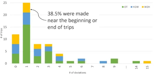
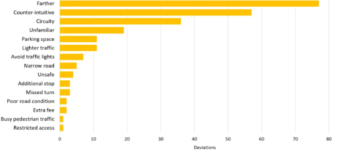
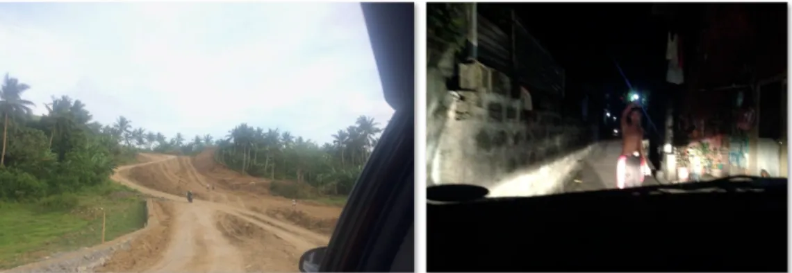
when they chose their own or a recommended route. . . 39 3.7 The factors for deviation and the number of deviations they caused. . . 42 3.8 The factors for deviation and the number of deviations they caused. . . 43 3.9 Images of roads recommended to Waze users that are not suitable for driving.
[Left] A dirt road and [Right] a residential street that can only be accessed on foot. These were all gathered from Twitter posts which are related to Waze trips. 44 3.10 A route recommended to P4 in one of their Home-to-Work trips. The
pur-ple line shows the fastest recommendation by the navigation application. The green line shows the actual route followed by the participant. . . 46 4.1 Examples of an optimal and an unselfish route between home and work
lo-cations. . . 54 4.2 The different types of motivation and behavioral regulation. In this
contin-uum, different forms of extrinsic motivation and behavioral regulation result to different motivational qualities. As you move to the right and develop a more self-determined extrinsic motivation, the motivational quality improves un-til intrinsic motivation is fostered. Going towards the left end of the spectrum means a person starts to lose whatever inherent interest they have and has to be controlled to perform a task with external rewards. This was adapted from139,141
and stylized by the Center for Self-Determination Theory. . . 57 5.1 The motivative and familiarity information added to the typical travel
infor-mation for each route recommendation. . . 63 5.2 The three types of motivative information used. At the bottom of each design
are the basic psychological needs supported by the information provided. . . 64 5.3 The critical mass information shown for the optimal and unselfish routes.
Be-cause of induced demand brought about by a faster travel time, the number of drivers shown in the optimal route (left) is relatively more than the num-ber of drivers taking the unselfish route. . . 64 5.4 The valence information shown for the optimal and unselfish routes. For both
route choices, it shows the estimated average travel time of all active drivers af-ter the user makes a choice. . . 65 5.5 The navigational information that uses simple positive framing of the
conse-quences of choosing a certain route. . . 66 5.6 The two types of road familiarity information shown to drivers for both route
choices. The left version shows the number of distinct roads that are familiar, while the right version shows the exact names of some familiar roads. . . 67 5.7 An overview of the study protocol. . . 70
5.8 The baseline (BL) version of the prototypical navigation app interface. Routes A and B are shown side-by-side. The top part shows the origin and destina-tion with the map below it. The bottom part shows the navigadestina-tional informa-tion that you would typically find in most navigainforma-tion applicainforma-tions. This part has 27 other versions for each experimental condition. . . 72 5.9 The additional parts of the navigational information section for the 6
treat-ment conditions. . . 73 5.10 The design versions of the navigational information section that adds
differ-ent combinations of motivative and familiarity information. The versions aligned in the same column use the same motivative information. For example, the two versions in the leftmost column both show critical mass (C) information. The versions in the same row use the same familiarity information. . . 73 5.11 A) The absolute number of trip conditions in which the participant chose each
route. B) The rate by which each participant selected Routes A and B. The red dot shows the median selection rate. . . 79 5.12 A) The number of trip conditions in which the participant chose each route
and distributed by the combination of motivative and familiarity information. B) The rate by which participants selected Route B per combination. The black dot shows the median selection rate. . . 80 5.13 A) The number of trip conditions in which the participant chose each route
and distributed by the trip scenario/type. B) The rate by which participants selected Route B under a trip scenario/type. The black dot shows the median selection rate. . . 81 5.14 The number of times the unselfish route (Route B) was chosen under each trip
scenario and design version. . . 82 5.15 The absolute number of participants who preferred each design version. Note
that there were ties with at most 2 versions. . . 84 5.16 The worth estimates of each design version. A) On the left is the plot of
erences without considering other factors. B) On the right is the plot of pref-erences of participants based on their autonomous and controlled motivation scores. Only score categories with more than 1 participant were included in the plot. . . 85 5.17 The worth estimates of each design version when the general causality
orien-tation is considered. Only score categories with more than 1 participant were included in the plot. . . 87 6.1 The selected routes from the map. The start and end points are the same for
all routes. The orange markers are where the conversations are delivered, only once per trip. The 2 diverging arrows from each route show the alternative turns given in the conversations, colored to represent the type of route they lead to. 96
6.2 A sample sequence of turn suggestions given in the OF (Optimal-Familiar) condition. It has a two-party conversation between the Optimal and Famil-iar voice agents. In this sequence, turn suggestions are first given by the 1st voice agent in the pair. They also start the conversation with the 2nd voice agent. After choosing a suggestion between the two, the trip continues with turn sug-gestions from the chosen voice agent, in this the Familiar. . . 99 6.3 The Wizard-of-Oz setup. [A] A participant driving in the virtual environment
and [B] the overhead view of the room with the location of participant, researcher and assistant. . . 101 6.4 The Towm3 map of the CARLA simulator. . . 102 6.5 Distribution of navigation choices per scenario. D refers to those who chose
the Familiar suggestion, O for Optimal suggestion, E for Explorer suggestion, and N for those who chose neither of the given suggestions. . . 106 6.6 Distribution of navigation choices per condition. The first row shows the
con-ditions under the Regular Day scenario, followed by the concon-ditions in the In
a hurry and Lots of time scenarios. . . 107
6.7 Distribution of confidence rating per condition. The first row shows the con-ditions under the Regular Day scenario, followed by the concon-ditions in the In
a hurry and Lots of time scenarios. . . 111
6.8 NASA TLX scores of each participant after each condition. The first row shows the conditions under the Regular Day scenario, followed by the conditions in the In a hurry and Lots of time scenarios. . . 115 7.1 A holistic approach, Navigo refines the pre-trip (Chapter 5) and en-route
tech-niques (Chapter 6), and combines them following a personality-targeted de-sign. . . 122 7.2 The baseline version of the Navigo interface. It shows the origin and
destina-tion at the top, a map in the middle, and the trip informadestina-tion at the bottom. 123 7.3 The personality-targeted design is based on the best representative score of a
driver. This is an overview of the step-by-step process of selecting the the best representative scores from the causality orientation and behavioral regulatory style scores. . . 124 7.4 A) The sequence of voice guidance when a two-party conversation is played
in the middle of following a route. B) The rationale spoken by the unselfish voice agent which differs depending on the motivative information of the per-sonalized design version selected for a driver. The underlined items are differ-ent depending on the trip type. The values shown here are used during a home to work trip. . . 126
7.5 The four routes used in the conduct of this user study. Route A and C are op-timal routes while Routes B and D are unselfish routes. The route illustration for Routes A and C includes points on the map where the conversations were played. It also includes the turn direction that was suggested by the unselfish voice agent. . . 130 7.6 The layout of the driving simulation window and the prototype interface
dur-ing the drivdur-ing task. THis is what the participants see while the experimenter is sharing the screen. . . 131 7.7 An overview of the study protocol. After the preliminary survey, participants
were assigned randomly to two groups. After which, they were scheduled for driving sessions that spanned for 3 days. They were not always consecutive days.132 7.8 How effective is it in encouraging an unselfish choice after the first
ses-sion? This shows the number of times each route choice was selected by drivers
in every session. The bar graph on the left shows the numbers for home to work trips, while the graph on the right shows the numbers for work to home trips.135 7.9 Can motivative and familiarity information help sustain the selection of
an unselfish choice? This shows the route choices of the 10 participants
af-ter each session. The flow from one session to the next indicates the switch in route choice. After following Route B in their second session, 5 participants continued to choose unselfishly in the third session. . . 136 7.10 Can two-party conversations convince drivers to switch to an unselfish
route? This shows the A) number of times the two routes were chosen in
ses-sions 2 and 3, separated by the trip purpose. On the right are B) the different route choices made by 6 drivers who chose Route A in the third session. . . 137 7.11 Can two-party conversations encourage drivers to continue following an
unselfish route? The two figures show the route choices made by all
partic-ipants in the home to work (left) and work to home (right) trips. . . 138 8.1 An initial prototype of an agent-based model of drivers that follow navigation
applications. It shows the effects on the traffic flow when a certain percent-age of them follow the navigation applications completely. Cars that follow navigation applications are colored pink while those that do not are colored blue. Each have unique origins and destinations. Origins are indicated by the yellow boxes while destinations are in orange. Traffic lights are also present in the model. . . 148 D.1 The Familiarity route and the voice guidance in English. . . 161 D.2 The different routes used for the voice-based technique described in Chapter
1
Introduction
Route information and navigation guidance provided by modern navigation applications can be redesigned to motivate drivers to choose unselfish routes. Doing so will realize their potential in managing traffic flow, adding positive social value for daily commuters. In 2050, we will see almost 70% of the global population move to cities, increasing car own-ership and potentially affecting our goals of achieving sustainability. These additional ve-hicles will slowly congest denser urban environments and complex road networks, wors-ening traffic conditions and bring forth a number of negative consequences103. While our current road networks and transportation systems are still keeping up with the rising de-mand, modern navigation applications such as Waze and Google Maps, and in-car navi-gation systems found in modern car models today are offering a slight reprieve in dealing with daily traffic conditions. At their core, these tools provide digital maps that show route options, traffic conditions, and other road or traffic advisories. To reduce driving distrac-tion, they also give turn-by-turn directions towards a destination. As commercial products, we are provided with a diverse array options which we can compare in terms of mobility, frequency of map updates and available information (Figure 1.1).
Figure 1.1:The spectrum of naviga on tools that are available commercially for drivers. Le most are in-car naviga on systems which typically come with a vehicle. Such naviga on tools are different per car make and model. One of their main advantages is that they can communicate with other cars of the same car make and access to maps do not need connec on to the Internet. In the middle are satellite naviga on tools or GPS devices. These can be bought separately from naviga on companies (e.g. Tomtom and Garmin) and can be mounted on any car. Rightmost are modern naviga on applica ons like Google Maps and Waze. They are run on smartphones and access to the most recent maps and route informa on is mostly free.
In this dissertation, I focus my investigation and designs for navigation applications, as they democratize the access to navigation services. As their core routing service becomes more advanced with machine learning and sensing capabilities, navigation applications are becoming integral in many commutes to monitor regular routes, to discover new ones and sometimes to avoid traffic congestion. These modern tools are free to download on most smartphones, have the latest maps, and with some utilizing the Intelligent Transporta-tion Systems of advanced cities. Maximizing built-in sensors and modern GPS, they collect floating car data to learn traffic conditions and further augments these with crowd-sourced reports from ordinary users93,165. All these information are fed into machine learning algo-rithms to produce models that can power their sophisticated routing algoalgo-rithms, allowing drivers to cut through traffic by sometimes suggesting unfamiliar routes and small, residen-tial roads.
1.1 Negative Externalities
Since the first GPS devices were made commercially available to consumers, engineers and designers have always centered their features around the individual driver. Understandably,
this has resulted to their modern commercial success as most modern car models include in-car navigation systems by default. For those who do not have that luxury, they can still download free navigation applications like Google Maps and Waze, which also offer turn-by-turn voice guidance.
A large user base has been a benchmark for an application’s success. However, the widespread use of such applications can sometimes have negative externalities as shown by a recent
work of Bayen et. al. In an agent-based model simulation, they have shown that as more drivers follow the shortcuts provided by navigation applications, smaller residential roads that run parallel or connected to highways experience unlikely congestion. Unlike traffic congestion on highways which can dissipate fast, these small roads will experience con-gestion for longer because of their low carrying capacity159. Insights from this model are also supported by anecdotal evidence of cities like Los Angeles experiencing local unprece-dented disruptions because of drivers using Waze17,161,175. These unexpected negative ef-fects have prompted some local communities to start gaming the system172and some gov-ernment officials to take legal action52. I argue that the major reason for this is how design-ers of navigation applications continue to only follow the principle that drivdesign-ers want the fastest or shortest path to their destinations (selfish Wadrop equilibrium169). Instead of directly addressing the problem of traffic congestion, these applications provide shortcut routes, promoting individualistic choices at the expense of other stakeholders in the system (e.g. other drivers, households in residential roads). Inadvertently, they cause transporta-tion networks to fall into inefficiency, showing the price of anarchy169.
As beneficial as these navigation applications can be for individual drivers to avoid traffic congestion or get to their destinations faster, it is worth looking into how we can include other stakeholders into the design of such applications and their algorithms to safeguard the interest of the communities where they operate. At the same time, we should investi-gate how navigation applications can reduce individualistic choices in other trip contexts. 1.2 Imagining a Distributed Future
Because of their fast technological advancements and ubiquity, many government stake-holders are optimistic of the potential of navigation applications in shaping sustainable driving behaviors12. Here, I envision a future in which governments can manage traffic flow on their roads by recommending unselfish routes to drivers. Following Wardrop’s
Figure 1.2:A toy problem illustra ng a central distribu on of drivers. This road network has 3 possible routes, with road BC as a one-way road. In a system op mal scenario, 100 drivers are equally distributed between routes ABD and ACD. Road BC is unused because it significantly increases the traffic flow in roads AB and CD. Not using all possible routes consequently reduced the average travel me of everyone to just 3.5 minutes, from 3.75 minutes in a user equilibrium scenario. This was recreated from Figure 1 of Colak et. al.31.
second principle169, consider the toy problem shown in Figure 1.2. In a user equilibrium scenario in which each driver chooses their own fastest route and ends up using all possi-ble paths, many of them will include road BC in their routes because it has a small link cost or fast travel time. Eventually, everyone’s average travel time becomes 3.75 minutes. Now let’s say cars are centrally distributed in the road network. So instead of letting them use all possible roads, it now distributes 50 cars each to use routes ABD and ACD. Since nobody is taking the shortcut path anymore (road BC), everyone’s average travel time becomes faster, from 3.75 minutes to 3.5 minutes. If we could rethink current features and designs of nav-igation applications to start encouraging unselfish routes that can lead to more sustainable futures, I believe that navigation applications has the potential for more. Implementing this in free applications can have a great impact because there is higher chance of mass adop-tion. But realizing this vision will take a concerted effort to address different aspects of the solution. In terms of the underlying infrastructure and sensing capabilities, there are still many open challenges on data sparsity and in ensuring the integrity of crowd-sourced re-ports151,124,167. However in this dissertation, I focus on the human-computer interaction aspect of this problem, specifically on drivers’ route choice and navigation behaviors.
1.3 Interaction with Navigation Applications Today
In recent years, in-car navigation systems and their mobile application counterparts have gained popularity among drivers170, especially those driving in cities and other urban areas with increasingly complex road networks. Looking at the user’s experience, several studies have found older drivers experiencing difficulties following the voice navigation46,99while younger drivers overly rely on the turn-by-turn navigation99. More recently, Brown & Lau-rier enumerated five normal, natural troubles of driving with GPS devices with regards to defining destinations, quality of routes, accuracy of maps and sensors, timing and relevance of instructions, and legality of recommendations23. All these have profound effects on achieving a positive experience.
By default, drivers are recommended the fastest route to their destinations, with alter-native routes either shown up front (i.e. Google Maps) or hidden for you to discover (i.e. Waze). While many people agree and say that they do want fast or short routes when asked at any given day, asking them again in actual driving contexts shows otherwise121. This is further supported by empirical evidence from GPS tracks and recorded actual trips that show drivers’ repeated non-preference of recommended fastest routes127,181,158and sudden deviations61,23,144. While there is great support for drivers to make decisions before starting a trip, there are gaps in current systems and applications that fail to consider their changing needs, contexts and preferences, which ultimately affect their compliance on the recom-mendation.
In Brown & Laurier’s work23, after they describe the common dilemmas faced by drivers and passengers with traditional GPS devices, they argued that in order for drivers to have more positive experiences and better instructed actions, developers should focus more on supporting their interpretation and analysis of new route guidance and information. In-stead of assuming that drivers have zero knowledge, navigation applications should allow them figure out what to do next.
Looking at these challenges and how we want future navigation applications to become tools in encouraging sustainable driving behaviors, I focus my line of research on answer-ing this central research question: How can we encourage drivers to follow unselfish
routes in their daily commutes? Specifically, I see two main challenges that needed to
be addressed:
Figure 1.3:Overview of the different studies I conducted over the course of three years as I gained a deeper under-standing of driver experiences with modern naviga on applica ons and explored different mo va onal techniques for displaying route informa on and delivering naviga on guidance.
• How do we make sure that drivers continue to follow an unselfish route (if they choose to do so) or convince them to switch to an unselfish route in the middle of a trip?
Additionally, how do we achieve these while supporting their sense of agency in their navigation decisions?
1.4 Encouraging Unselfish Routes
In order to redesign route information and navigation guidance provided by modern navi-gation applications to motivate drivers to choose unselfish routes, I started with a formative study that deepened my understanding of a driver’s use of navigation applications. Using key insights and design implications, I refined my research questions and began the pro-cess of rethinking navigation applications as a form of civic technology by evaluating two separate approaches – each focused on a different phase of the driving navigation task. I cap-off my PhD research by combining the two approaches and refining their designs to form a holistic approach towards a personality-targeted navigation application. After read-ing this dissertation, I hope I can convince you that navigation applications can be more than a routing tool and can be transformed into a civic technology for social good. Figure 1.3 shows the different studies I conducted to answer my central research question.
1.5 Structure
I begin this dissertation by reviewing the previous literature around navigation applica-tions, HCI of recommender systems, traffic psychology and behavior, and factors that af-fect route choice (Chapter 2). In Chapter 3, I describe a formative study that investigates how drivers interact with modern navigation applications and what affects their route choices. In order to support the self-efficacy and agency of drivers, Chapter 4 discusses Self-Determination Theory which focuses on the different types of motivation and what techniques can be used to internalize motivation. It is then used to inform the designs in this dissertation. In Chapter 5, we explore the use of the Self-Determination Theory in de-signing autonomy-supportive navigation applications and investigate the effects of adding motivative and familiarity information to encourage the choice unselfish routes before a trip. In Chapter 6, I focus on the on-trip voice guidance and explore the use of two-way conversations to influence route choice when an alternative route is made available. Then in Chapter 7, I integrate the display of pre-trip motivative and familiarity information with the delivery of two-party conversations as voice guidance. I conclude this dissertation with a summary of my key contributions as well as an envisioning of future directions towards the design and evaluation of altruistic navigation applications (Chapter 8).
2
Related Works
Advanced driver-assistance systems (ADAS) have become ubiquitous in modern vehicles because of the recent developments in communication and sensor technologies. They are primarily developed to improve driving performance, and car and road safety by providing automation and adaptive capabilities to vehicle systems. One of the most widely used tool for driver assistance are automotive navigation systems, which were initially designed to provide digital maps, route guidance for the shortest path to a destination, and traffic inci-dent information106. As more private vehicles occupied our roads and more cities are being designed to accommodate and regulate their widespread use, modern automotive naviga-tion systems now also provide informanaviga-tion on the cheapest and fastest routes, and traffic condition.
Today, more than half of the world’s population call cities their home due to urbaniza-tion and a rising middle class164. As we see a consequential increase in car ownership, our efforts in promoting and ensuring sustainable cities are at stake. With dense urban districts and complex road infrastructures, persistent traffic congestion poses a negative effect on our productivity, health, environment, and social equity103. The worsening traffic
con-ditions have compelled drivers to circumnavigate congested roads and several solutions have been introduced to address this growing problem. Intuitively, cities invest heavily on improving and increasing road network capacity; but adding more links between origin-destination pairs was proven to be counterintuitive and may cause longer travel times22,6.
Another approach was to efficiently manage traffic flow on existing road infrastructures by connecting current fleets to Intelligent Transportation Systems (ITS). Cities have al-ready invested heavily on ITS infrastructure such as toll gantries, adaptive traffic signals, variable-message signs, and traffic detection systems, among others – all aimed to regulate road use, to capture and provide situational information to drivers, and to redirect them from congested routes. At the same time, in-car navigation and other advanced driver-assistance systems are continually becoming more context-aware – communicating with other vehicles, the ITS infrastructure, and other smart devices, as well as detecting its imme-diate environment8,16,149. However in some cases, in-car navigation systems are barely used and noticed79, are becoming too complex to operate80, are not always updated with the latest maps, and sometimes without access to real-time traffic information, which directly impacts their adoption and forcing drivers to find other options.
In the absence and or shortcomings of in-car navigation systems on some vehicle models, smartphone navigation applications such as Waze and Google Maps, have become a pre-ferred alternative for drivers who experience traffic congestion on a daily basis. In the App Annie Rankings*, Google Maps has consistently been the top choice since its introduction
of GPS turn-by-turn navigation in 2008. Meanwhile, Waze reported in 2016 that they are already being used in 185 countries by more than 65 million monthly active users170. Other popular navigation applications include HERE WeGo, MapQuest and Bing Maps, and in other countries like Japan, Navitime has been a long time favorite. These navigation appli-cations are free to use and has the latest maps. With the improved sensors in smartphones, these navigation applications started using floating car data from online users to estimate traffic conditions and uses that to suggest optimal driving routes. Maximizing connected drivers, Waze crowd-sources traffic and accident reports, and advisories of police presence, speed traps, and road closures to supplement its turn-by-turn navigation93,165, setting it apart from traditional navigation systems while supporting the notion of navigation as a so-cial activity among drivers and navigators58. At its core, modern in-car navigation systems and navigation applications are routing services, but they are also considered recommender
systems because of their sophisticated recommendation engines that use actual and or av-erage road speeds for calculating fastest routes, and learn new routes to suggest to other drivers†. These information on existing road infrastructure and driving behavior have
in-spired governments to consider their use in influencing future mobility patterns18,12. 2.1 Interacting with Recommender Systems
With the incredible amount of data from digital and social media, and those from con-nected devices and sensors in the Internet of Things, recommender systems have been a boon to digital natives in making sense of and discovering new information. This popu-larity has gained significant attention to its evaluation in HCI, especially for a more user-centric approach. Knijnenberg et. al.86evaluated collaborative filtering recommender systems and found that increased usage is strongly correlated to a positive personalized experience, but their perceptions, experiences and behaviors change over time. These are also influenced by personal and situational characteristics such as age, gender and domain knowledge. Additionally, they found that when users perceive a recommendation set as more diverse, they see it as more accurate and less difficult to choose from. This is echoed by Ekstrand et. al.50when they found users choose a system with more diverse recommen-dations. They also emphasized the importance of building trust in the early use of recom-mender systems as their results show negative effects of novelty.
Comparing between collaborative, content-based and hybrid recommender systems, Wu177found that users mostly preferred recommendation sets that use hybrid filtering. In particular, users see more benefit in recommendations that match their own behavior history (content-based) than those that match the history of similar users (collaborative). Moving to a different type of system, Rong and Pu78developed a personality-based recom-mender system and found that novice users had an easier time building their profiles using personality quizzes because it doesn’t need much domain knowledge. When users were asked to build profiles for themselves and their friends, they perceived the recommendation for their friends as more accurate. Much of these works have focused on user perceptions and behaviors towards the main approaches to recommender systems with a single crite-rion for matching, and they have demonstrated user-centric evaluations besides algorith-mic accuracy. However, further analysis is needed for the growing number of mobile and
ubiquitous recommender systems that incorporate multi-criteria preferences, probabilistic models, and temporal, spatial and crowd-sourced information.
2.2 Ongoing Struggles with Navigation Systems
With a focus on GPS devices, Dingus et. al.46did camera and instrumented car studies for drivers who use TravTek. They found that older drivers have a difficult time driving and navigating, and despite being more careful, they still made more safety-related errors. Generally, drivers benefited most when using turn-by-turn guidance with voice, resulting to less glances to the device and faster travel times. In their naturalistic field study, most drivers used the GPS device in their rental cars. Al Mahmud et. al.99also found old drivers having difficulties with in-car GPS. As a result, they tend to not follow it completely due to reliability concerns and high amount of instructions. On the other hand, the younger drivers were found to be too dependent at times.
Focusing on more portable GPS devices, Brown & Laurier’s study23documented five problems that drivers usually encounter during trips and came to the conclusion that nav-igation with GPS devices is a skilled activity. In order for a driver to have a positive expe-rience and make suitable instructed actions, other than giving focus on providing very de-tailed instructions which can overwhelm and cause more confusion, it is equally important to support the driver’s interpretation and analysis of an instruction or new information as they move and figure out what to do next. Clearly, these works have shown how driving and navigating performance is affected by the use of early smartphone, dashboard-mounted and in-car GPS devices. But with a new generation of navigation applications that dynami-cally adjusts to real-time and historical contextual information, and provides sets of crowd-sourced information, further analysis is needed to see whether there are changes in navigat-ing practice and decision maknavigat-ing, and whether they are associated with the type of trip, trip context, and road conditions.
More recently, Antrobus et. al. investigated how effective the use of SatNav devices are compared to collaborative passengers in helping drivers learn routes and become more aware of their environments while navigating9. They found that drivers learned the routes better after they drove with a collaborative passenger because they were using more land-mark, road sign and dynamic landmark descriptors in telling the next navigation instruc-tion. In contrast, the SatNav was only giving distance descriptors. Additionally, the
collab-orative passengers were more helpful because they confirm what the driver is interpreting as the next navigation maneuver, give confidence boosting words to the driver, and provide proper orientation.
Despite the continuous improvement of such navigation tools, although mostly on the digital maps they use, these recent works suggest that drivers continue to experience prob-lems with the provided information and turn-by-turn navigation guidance. Additionally, they have focused on early smartphone, dashboard-mounted and in-car GPS devices. But with a new generation of navigation applications, I’m curious whether there are changes in navigating practice and decision making, and whether they are associated with the type of trip, trip context, and road conditions.
2.3 Route Choice Behavior
Because of the ubiquity, cost-effectiveness, and positive utility of smartphone navigation applications, there is growing optimism of the potential of navigation applications in im-proving urban participatory sensing152,179,151and in shaping sustainable mobility patterns among driving citizens18,12. Key to the realization of this potential is the navigation applica-tion’s ability to influence the route choice behavior of drivers.
Route choice is a decision making task that actively occurs in driving navigation47. It is a driving behavior that is based on their active consciousness of their surroundings, knowl-edge of relevant travel information about possible routes, and recollection of past naviga-tion experiences. According to Ben-Elia and Avineri, there are three categories of travel information that can affect travel behavior, namely experiential, descriptive, and prescrip-tive18. Experiential information are provided as feedback or repeated information from previous experiences. In actual implementations, they are passively captured in the back-ground but are mainly used to train machine learning models required to improve digital maps and to provide route recommendations for all users. Thus, experiential information has never been utilized for personalized navigation experiences and drivers still rely on their cognitive functions to retrieve experiential information from memory. On the other hand, descriptive information depicts current conditions based on historic or real-time data such as estimated times of arrival and traffic conditions. Utilizing experiential and descriptive information, prescriptive information can come as suggestions (e.g. shortest, fastest, and cheapest routes) and or guidance (e.g. turn-by-turn directions) to help drivers optimize
their travel time and positive driving navigation experience. Nowadays, most modern nav-igation applications provide descriptive and prescriptive information as their main features to inform and redirect drivers148. In the absence of in-car navigation systems and naviga-tion applicanaviga-tions, drivers can also access these informanaviga-tion through variable message signs, which is another type of advanced traveller information system (ATIS) that are physically installed on many major roads in cities. Unselfish routes are typically considered and pro-vided as prescriptive information in many route choice studies and in some modern naviga-tion applicanaviga-tions. And even so, there is still relatively few studies about the implicanaviga-tions of prescriptive information on route choice.
In Chorus et. al.’s30and Ben-Elia & Avineri’s18surveys of literature, they have high-lighted the extensive focus on the positive effects of experiential and descriptive infor-mation to influence the travel behavior of car drivers. Experiential inforinfor-mation has been proven helpful in adapting to uncertain conditions, while descriptive information is partic-ularly valuable in coping with non-correlated and Black Swan events like road accidents and sudden bad weather. As a universal behavior, Abdel-Aty and Abdalla found initial evidence from a small percentage of their participants who showed more instances of deviation from a regular route when they had access to travel information1. In addition, drivers were also shown to be more likely to change and follow a recommended route when they see it pro-vided by variable message signs along the road120,51.
But the mere provision of such information are sometimes not enough. Route choice and compliance were also shown to be dependent on the quality of route information30. In an early study, Chen et. al. conducted an analysis on the effects of information quality and credibility on drivers’ compliance to travel information provided by advanced traveler information systems28. In an interactive multi-user simulation environment, three aspects of information strategies were tested on participants. First is the nature of information (de-scriptive or pre(de-scriptive). Second is information quality, which are based on six levels of precision, from very precise travel time estimates to random values. Third and last is post-trip feedback. They found that drivers show high compliance when drivers are provided with prescriptive information with very precise travel time estimates. In practice, pre-trip travel times do not sometimes match the realized travel times because of dynamic traffic sit-uations which were not accounted for at the beginning. But since travel time reliability is a major consideration for route choice98,27, several strategies have been explored like showing ranges157and presenting standard deviations from the mean travel time19.
In a conceptual framework for route choice behavior, Bogers et. al. showed the impor-tance of habit, riskiness and presentation of past information21. Habit is when drivers learn and regularly use routes that leads to their unconscious selection of the habitual choice and bias against other alternatives. This study also showed that drivers improve their nav-igation performance when they are shown the realized travel times of all their past trips, as well as the forgone outcomes. This elaborate and historical information acts as a memory aid for drivers, however it cannot be ascertained how this can be effectively shown in prac-tice. Lastly, drivers were shown to be naturally averse to risk. Thus, they would most likely choose a route with high certainty.
When alternative routes, like side roads, have faster travel time, drivers are more likely to choose them. Ringhand & Vollrath found in 2019 that even just 20-second gains can get around 20% more drivers to shift to side roads134. And relative increases in travel time of recommended routes can negatively affect their chances of being selected1,11,134. But with better familiarity, chances can be levelled and can lead to some positive impact on driver’s route choice and compliance5,21,150,11.
Other than travel time and familiarity, other types of travel information also showed ef-fects on route choice. In the work of Ramaekers et. al., they showed that a trip’s purpose (e.g. work-related) has an effect, along with trip length128. In cities with vast networks of roads and intersections, drivers were shown to heavily consider the effects of traffic lights on their travel time. Regardless of whether the recommended route has a longer distance or travel time, drivers would still choose them if it avoids traffic lights1,118,116,166,132,133. As much as possible, drivers avoid roads or routes with many traffic lights116and those with long waiting times even if there are only a few encounters132. Although it should also be noted that drivers often underestimate their judgement of waiting times178. In-stead of showing just the actual travel time of two route choices, a recent study also showed that routes that positively frame travel time gains were chosen more than the way drivers avoided routes with negatively framed travel time loses135. When it comes to variable mes-sage signs, Peeta & Ramos found drivers were more willing to follow recommended reroutes when they are shown information about road accidents and travel time delays120.
Route choice and navigation in general do not only rely in the type and quality of travel information provided. More often than not, drivers make navigational decisions based on a combination of travel information and external events and factors. In the early work of Gärling et. al., they found that time pressure has a combined effect with information
on the recommended route63. But when Ringhand & Vollrath investigated this further, they found effects of time pressure on decision making time but not so much on route choice132. But even though some alternative routes are shown to be faster, their chances of being selected are also affected by the complexity of a route’s traffic situation. Considering a variety of factors like speed limit, road and lane widths, intersections, traffic from vari-ous directions and sources, disruptions, pedestrian foot traffic, and points of interest, the same authors found that less drivers choose an alternative route when it has high complex-ity (e.g. has oncoming and pedestrian traffic) even if the route can be faster or shorter134. In addition, Thomas & Tutert found that the physical properties and layout of roads within a route also play an important factor in route choice160. For example, routes that include circumferential or orbital roads tend to be chosen more by drivers compared to those that are shorter and passes through the city center.
All things considered, it can be a cause for concern whether drivers would ever choose unselfish routes for their daily commutes, especially since these are already familiar and regular routes. In a distributed future wherein traffic management systems provide recom-mendations, unselfish routes would be sub-optimal alternatives with longer travel times and or distances133, and is aimed to minimize the marginal cost of one’s route choice on other drivers31. However, it can also be the case that the recommended unselfish route would be something familiar to the user but seldom used by other drivers. Whichever it may be, designers have to look into applying behavior change techniques in order to in-crease chances of selection and compliance for unselfish routes. For example, drivers can be nudged to choose unselfish routes by showing them as the default route recommendation, which is similar to how Waze automatically starts its navigation guidance for the fastest route13. Aside from the strategy of highlighting or making default the system optimal route to drivers, designers can also show the context and rationale behind the recommendations. This is under the assumption that if drivers would know why they are being recommended a system optimal route, they could somehow align their decisions with it. One way of do-ing it is by informdo-ing the drivers about the source of the recommendation. In two stated route choice studies where drivers were asked to choose between the fastest route and the system optimal route, they were informed that the system optimal route was given by a traffic management system84,133. In Kerman et. al.’s study, they found that route advice was considered more by participants when it showed different attributes of the alternative routes and when it shows that it can support traffic management outcomes. There is more
effect when it is labelled personal for the driver. However in their stimuli, there is no indi-cation which among the choices are system optimal. Ringhand & Vollrath did a two related studies by investigating the combined effects of presenting the source of recommendation and highlighting the system optimal recommendation133. When they only highlighted the system optimal recommendation to the participants, their individual compliance of drivers increased by a small fraction. But when they added information about the source of the recommendation and described a hypothetical traffic management system in a followup study, it did not show any effect on route choice unlike in Kerman et. al.
Recent attempts to nudge drivers into choosing unselfish routes have so far focused on providing information about a hypothetical source of recommendation and on explicitly labeling them as recommended by a traffic management system. Both information strate-gies seem to appeal to the extent of a driver’s altruistic nature. Although results showed that the driver’s decision making was partially correlated with their altruism, both strategies were not really designed for behavior change at the onset. In this dissertation, my goal is to explore other types of travel information that are grounded on behavior change theories to achieve desired route choice outcomes.
2.4 Driver’s Compliance
Developers have so far focused on the assumption that drivers would always follow the fastest route to a destination. For most navigation applications, drivers are provided with a number of recommended routes based on a criteria and they can select which one to fol-low. By default, the fastest route criteria is set unless customization are made. In the case of Waze, it immediately starts the turn-by-turn navigation and leaves it to the user to check alternative options93. However, this doesn’t seem to be the case based on studies exam-ining GPS track data. Zhu and Levinson181noticed from GPS tracks that drivers do not always choose the shortest path in their daily commutes. In the follow up work of Tang et. al.158, some drivers even take a different route each day for their commutes. Recognizing that desired driving experiences have an influence on route choice and vice versa, Pfleging et. al.’s121web survey show that the most considered factor for drivers is whether it is the fastest route, but when asked to choose a route from work to home using a prototype nav-igation screen, 49.1% chose the fuel-efficient route. Only 18.4% and 3.5% chose the fastest and shortest routes, respectively. While these provide rich empirical evidence, it is not clear
whether the same prioritization and decision making holds true in real driving scenarios under different circumstances.
Relatedly, Fujino et. al.61conducted a more recent study to investigate the phenomena of drivers deviating from the recommended optimal routes of in-car navigation systems and where they usually happen. They analyzed GPS tracks that were collected over 4 years within a 20km2area in Kyoto, Japan. They found that drivers have made significant
devi-ations on intersections with poor on-road signages and those near tourist areas. They also speculated on possible reasons for the deviations based on the physical characteristics of the intersections. While these studies already provide empirical evidence on the surprising route choice and non-compliant behaviors of drivers, none of them had prior knowledge whether the observed drivers used prescriptive information from in-car navigation systems or navigation applications. In the case of181,158,61, they had no information on the intended route of the drivers nor do they know if the drivers were initially following the guidance of the in-car navigation system used to collect the GPS tracks. Thus, further investigation is warranted to understand why drivers deviated from the recommended optimal routes and whether they chose a recommended route in the first place.
In HCI, Brown & Laurier’s study23also noted instances of drivers not following GPS recommendations from their corpus of naturalistic video data. They argue that GPS use is rather a skilled activity as drivers need competency to overcome the normal, natural
trou-bles that GPS devices make. Several of these problems such as complex routes, superfluous
instructions, map and sensor inaccuracies, and timing of instructions, offer a glimpse as to why GPS recommendations are not followed. Addressing the complex route problem, Patel et. al.119found that drivers prefer simplified route instructions using familiar landmarks.
As more drivers use descriptive and prescriptive information from navigation applica-tions and more government stakeholders seek to use them in managing road networks, it is crucial that navigation applications become successful in shaping the travel behavior of connected drivers. Sharma et. al.149argues that behavioral adaptation is directly affected by the degree of compliance a driver has with the information provided by navigation appli-cations. Although they are referring to connected vehicle technologies, the same assertion can also be made for navigation applications because they provide the same kind of infor-mation. It is worth exploring how we can better utilize descriptive information and present prescriptive information to create navigation experiences that encourages behavioral adap-tation.
2.5 Behavior Theories in HCI
Human behavior is an action that someone does as a response to antecedents40. When one responds repeatedly to a situation or stimuli in a similar manner, changing them can be challenging. In order to understand why we stick to regular responses, behavior theories allow us to predict future responses using their underlying concepts, propositions and con-structs65. Several theories have emerged from psychology in order to help explain and pre-dict desired behavioral outcomes in education, health and sports, to name a few.
In this section, I will discuss some behavior theories that have been used extensively in HCI research74. First is Social Cognitive Theory which posits that humans can learn new behaviors by observing other people or models performing that desired behavior15. Typ-ically, learning about the behavior and its consequences happens through social interac-tions, physical environment, and media exposure. As an ecological theory, it can be used to ground interventions that maximize the behavior change potential of these external influ-ences. Focusing on one’s beliefs, the Theory of Planned Behavior posits that one’s inten-tion to perform an acinten-tion or behavior is shaped by their normative belief or attitude, sub-jective norm, and perceived behavioral control or self-efficacy7. It links a person’s beliefs to their performance of a behavior by incorporating perceived behavioral control with the the-ory of reasoned action. In a similar manner but specific for the health domain, the Health Belief Model suggests that a person’s performance or avoidance of health-promoting be-havior can be explained by their perceived susceptibility to and severity of a health problem, perceived benefits of doing the action, perceived barriers to performing the behavior, and self-efficacy122,136. Besides balancing these beliefs, the health-promoting behavior must also be triggered with a cue to action. Unlike previous theories that focus on external influences and personal beliefs, people following the Goal Setting Theory write an action plan, which is a physical artifact or document that is meant as a memory guide. By referring to the ac-tion plan, they can be motivated to perform the intended behavior97.
Although the aforementioned theories have already been used to implement interven-tions for behavioral outcomes in different aspects of life (e.g. education, health and well-being, sports, life goals), all of them are focused on personal gains. In this study, my goal is to promote altruistic behavior for drivers by having them choose unselfish routes. Thus, it would remain a challenge if there is only focus on extrinsic aspects of behavior change (e.g. rewards, challenges, influences). If a person does not have an altruistic behavior, we must
design strategies that will allow them to have a conscious valuing of the desired behavior until it becomes part of one’s self. This process of internalization can improve the quality of motivation, from amotivation to intrinsic motivation.
Motivation is an important construct of most behavior theories and is what moves us into action. However, what most theories do not consider is that motivation varies from person to person140. Self-Determination Theory focuses on the motivation aspect of be-havior change and introduces different types, sources and orientations that affect the qual-ity of motivation139. Specifically, it suggests that people can have intrinsic motivation, amotivation, and a spectrum of extrinsic motivation towards an event or action. The qual-ity and type of motivation can change over time depending on how the environment sup-ports certain basic psychological needs. Because of SDT’s focus on internal processes, it has since been used to understand the development of one’s motivation and self-determined behavior171. Lastly, they have been applied for interventions and applications designed for life’s various aspects and have shown to deliver long term benefits59. Here, I inform my de-signs using Self-Determination Theory as it allows for better sustainment of the desired behavior (i.e. choosing unselfish routes).
2.6 Technologies for Behavior Change
As technology becomes ubiquitous in our everyday lives, HCI researchers and experts from behavioral sciences have been working in parallel and in collaborations to develop interventions that support and sustain behavior change74. Other applications use theories from behavioral economics, like Nudge theory90,70,26, in implementing persuasive tech-nologies56,55,57,85,91,145that use persuasion and social influence in order to change a person’s behavior. However, Fogg clarifies that these techniques are different from those that coerce users into committing an action55.
Behavior theories and persuasive techniques have been used extensively in technolo-gies that support health and fitness outcomes37,95and other life domains105. For exam-ple, they have been used to inform the design of whole applications that support healthy eating77,36,113,92,14,131, regular exercise32,34,33,60,75,41and good health maintenance123,155,115. They are also used in applications that help users reduce stress88,64, stop smoking3,73and improve privacy decisions71. Aside from whole applications, behavior theories have also been used to design specific features of an application155,73.

![Figure 3.3: Traces of the [Top] naviga on applica on’s recommenda on in violet, [Middle] devia ons made by the driver during the trip (arrows symbols), and [Bo om] the actual route taken by the driver in green.](https://thumb-ap.123doks.com/thumbv2/123deta/9903051.998639/41.892.209.690.155.462/figure-traces-naviga-applica-recommenda-middle-symbols-actual.webp)
![Figure 3.4: Synchronized video clippings of the [Le ] dashboard camera video and [Right] the applica on screen record- record-ing.](https://thumb-ap.123doks.com/thumbv2/123deta/9903051.998639/42.892.147.744.149.390/figure-synchronized-clippings-dashboard-camera-right-applica-screen.webp)