Cloud‑based Virtual Reality Technology for Representing Design Guideline of Urban
Residential Environment
著者 李 雪飛
著者別表示 Li Xuefei journal or
publication title
博士論文本文Full 学位授与番号 13301甲第4156号
学位名 博士(学術)
学位授与年月日 2014‑09‑26
URL http://hdl.handle.net/2297/40519
Creative Commons : 表示 ‑ 非営利 ‑ 改変禁止 http://creativecommons.org/licenses/by‑nc‑nd/3.0/deed.ja
i
Dissertation
Cloud-based Virtual Reality Technology for Representing Design Guideline of Urban Residential
Environment
Graduate School of
Natural Science and Technology Kanazawa University
Major Subject:Environmental Science Course:Environment Planning
School Registration No.: 1123142413 Name: Xuefei LI
Chief Advisor: Professor Zhenjiang Shen
ii
Contents
Chapter 1 : Introduction ... 1
1.1 Background ... 1
1.2 Objectives ... 2
1.3 Brief Literature Review ... 3
1.4 Research Method and Thesis Organization ... 4
Chapter 2 : Planning Review of the Residential Environment of the Low-rent Housing: A Method to Solve Low-rent Housing Space Insufficiency ... 7
2.1 Introduction ... 7
2.2 Research Approach ... 9
2.3 Investigation and Study Area ... 10
2.4 Living needs Analysis in Low-rent Housing Residents ... 12
2.4.1 The Indoor and Outdoor Factors from the Questionnaire Survey and Interview ... 12
2.4.2 The Physiological Needs ... 13
2.4.3 The Social Communication Demand ... 15
2.5 Reviewing Outdoor Design Guideline for Low-rent Housing Environment Improvement ... 16
2.5.1 Design Guideline for the Low-rent Housing Project ... 16
2.6 Low-Rent Housing Environment Improvement For Indoor Space Insufficiency ... 18
2.6.1 The Interlaced Functional Outdoor in Guideline ... 18
2.6.2 The Establishment of the “Private” Yard in Guideline ... 19
2.6.3 Public Space Design for Indoor Insufficiency ... 20
2.6.4 The Outdoor Environment Design Review Summary ... 21
2.7 3D model Helps Representing the Guideline ... 22
2.8 Conclusions in this Chapter ... 24
Chapter 3 : Using virtual global for Representing Design Guideline of Urban Environment 25 3.1 Introduction ... 25
iii
3.2 Research Approach ... 27
3.3 Using Google Earth to Express Urban Design Guidelines in DaTong Region 29 3.3.1 Traffic Guidelines ... 30
3.3.2 Architecture Guidelines ... 33
3.4 Environment Guidelines ... 37
3.5 Conclusions in this Chapter ... 41
Chapter 4 : Cloud-based Virtual Reality Technology for Design Review in Different Platforms ... 43
4.1 Introduction ... 43
4.1.1 Current issues in public comprehension and participation ... 43
4.1.2 Communication in public participation ... 44
4.1.3 About cloud computing ... 45
4.1.4 Review of Cloud computing for Design Coordination and communication ... 48
4.2 Research Approach ... 48
4.3 A Case study: Concept design of Pedestrian Bridge "The OASIS-symbol of Shibuya in 2012" ... 49
4.4 Coordination and Communication Using Cloud-Based Virtual Reality System 54 4.4.1 Design Coordination Using Cloud-Based Virtual Reality System ... 54
4.4.2 Public participation Using Cloud-Based Virtual Reality System ... 55
4.5 Comparison on Three SAAS Platforms ... 57
4.6 Conclusion in this Chapter ... 59
Chapter 5 : Conclusion ... 61
Publications: 63 Appendix: 64 A. Low-renting House Environment Design Concept (in Chinese) ... 64
B. The Concept Design of OASIS ... 68
C. Snapshot of Automatic Experience of the Guide of the Concept Design of OASIS (.avi file attached in the Appendix folder) ... 69 References 69
1
Chapter 1 : Introduction
1.1 Background
Modern society has been overwhelmed by the increasingly information of geospa- tial data year by year. Users of virtual globe can easily zoom the point of view from the globe level, country level down to a specific street, recognizing their own houses.
Web-based virtual globe has generated huge number of digital content including maps, satellite photos and countless users’ comments and text. Besides, those geospatial information connecting with environment, architectures, climate and so on, can have a lot to do in solving the practical problem of the world.
However, to derive such knowledge it need more than the automatic system or human manipulator alone in an effective way. Thus the computational 3D modeling techniques need to link with the cartographic method and interactive pictures together to favor the voluminous analysis with interaction and communication within multi- users, only in which way the operators may get a smooth visualized sense of the practical project and have a decision making support platform.
And Virtual Reality environment have the experiential features oriented from the following aspects: immersion, interactivity and sensorial feedback. Immersion can be summarized as that surrounded by the simulated environment the user has the sense of feeling or consciousness of what presences in the depicted world (Schuemie, 2001).
Interactivity, is the ability to control (make & receive) the responses reflected in the simulation environment as a result of human initiative thinking or body movements (Achten, Roelen, 1999), which no doubt deepen the impression of the environment to the actor.
The most common utilization of Virtual Reality in urban planning or design project is to experience around the simulated 3D environment. Researchers have been work- ing on developing virtual reality as a tool for design & planning exploration and evaluation. Because creating virtual model is much easier and cheaper than building a physical model, virtual reality techniques have been widely employed in visualizing the design results. In other words, virtual reality can be used as a tool to design and build up the target model including the surroundings. Now Virtual Reality on the design concept creation has been adapted by designers and architects, so as for
2
representing to the customers. By exhibit the design concept, virtual reality system favors the communication during the designing process, and also for the public the understanding, which provides full images of spatial relationships of the design to the audience instead of the conventional raw and text imagining. In this way, VR has this characteristic advantages to help the audience to get a complete image of the spatial relationships towards a particular design work. Thus, virtual reality system, especially for the nonprofessionals, can be employed in learning processes, helps the public to get a better understanding of the planning and design policy or regulation.
The subject focus on looking for Virtual Communication (towards teachers & stu- dents, or designers & public) in the mode of city design and planning new analysis model and way of presentation, by the virtual reality system, which includes UC win- road, Google Earth and other tools might partly involve augmented reality, which may increase effectively the efficiency of the stakeholders’ understanding the urban planning operation process and the design results.
1.2 Objectives
Based on the condition mentioned above, there are still deficiencies need to make steps forward. This PhD research targets on how cloud-based virtual reality technolo- gy representing design guideline of urban residential environment. We attempted to employ cloud-based virtual reality technology to support stakeholders’ comprehen- sion of urban design guidelines, compared with conventional planning documents and drawings
This dissertation has some objectives to try to give the solution:
1. 3D modeling is not only for presenting the design work, and also how to helps to express the design guideline to the first party (non-professionals), proving the design effectiveness.
2. Virtual global widely support other plug-in, which shows diverse flexibility, but undoubtedly separates the functions to users, especially for the nonprofessional background users, lowering the ability of controlling the process. How to connect the nonprofessional background users with the virtual reality system for their comprehension.
3. Public get better comprehension with the synchronized 3d environment and the alternative choices, however still not easy to make alternative themselves
3
but only to give the suggestions in text. Because of the large amount of 3d modeling, it is not smoothly for the public to experience the virtual environment in end servers, at least which are limited. The alternatives of platform for the end users need to analyze and towards which target group people each platform has a better performance.
1.3 Brief Literature Review
In the recent decades, urban planning processes has been improved by the fast developing field of the geospatial information in modern society (Huang, 2003).
Online GIS system can be employed to generate urban design & planning visualized concept and also assemble data, which makes the general public with no professional skills could involve in urban planning procedures as well (Drummond, 2008).
In the beginning, web-based GIS can only provide the function of image exhibition including the simple sketch and maps onto the internet. To meet the increasing demand of the public’s expectation of design visualization, it has been considered more and more about the 3D visualization technology.
Comprehensive spatial media have been used in researches such as photography, video, text and GIS data in the process of urban planning and design to try to involve more public participation and let the public have a better understanding.
( Matsubara,1991; Michael, 2001).
Alternatives in design tools are provided also for the general participants to experience a virtual world, which helps the stakeholders to get a better concept and involved during planning process.
For some specific design project, visualization of planning and design alternatives are proposed to encourage public involvement during decision-making process (Pettit, Nelson, 2004). In order to collect comment and suggestion through the Internet, a public outdoor space visualization tool is developed as a collaboration system of online design (Shen, 2003).
But most of the 3D visualization project results were specifically towards to the individual projects at the same time isolated from the real environment of the existing site or the region. If the end users want to visualize those 3D concepts, they have to download all the model as a whole package firstly. The process may be finished in a hidden thread so that the users might not aware, but it still takes quite a long time.
4
Never the less those results only provide a channel visualizing design project, but do not provide the possibilities for interaction with the visualized environment, thus the impact of public participation is limited.
During the last few years, 3D virtual reality technology in cloud-based system has become matured and public have get more used to the virtual globe technologies. This online globe-based visualization tool has changed the way the stakeholders understand, interact and control the geo-information data (Butler, 2006). This virtual globe-based visualization technology use Web Services to support 3D model sharing and modification in urban planning, developing the framework for the public comprehending the urban and architecture information. (Huayi Wu, 2010)
So far, present computer technologies of VR on the internet can be employed by users across locations to come together and create a virtual world by presenting, sharing and selecting different design elements. A visualization tool is developed (Shen, Kawakami, 2008) to achieve consensus within the local committee on townscape planning design. Stakeholders could use different visualize alternatives of design elements in synchronization, and experience the scenes of the generated virtual world, with multiple functions combined in the townscapes.
The service oriented architecture system provides geospatial information of planning and design to expand as one or many servers, including the personal laptop of individual end user. With the service oriented system’s capacity of distributed complex information and resources, other conventional methods can also be integrated into the system to involve more friendly user experience for the end users.
In this way the spatial information tool is merged to help the general public to perform tasks such as seismic resistance, solar power calculation and performance analysis, as the professional designers do.
1.4 Research Method and Thesis Organization
This PhD research targets to the communication between the designers and the stakeholders during the process of urban planning, by using cloud-based virtual reality technology for representing design guideline especially for urban residential environ- ment.
The research starts from using 3d model to present the guideline. In this research we attempt to achieve new design method of the residential environment of low-rent
5
Housing, we attempted to employ a practical project to present the concept. Firstly we investigate the low-rent housing residential area in Tianjin, China. With the interview of the local, the characteristics of the residential towards to the environment are analyzed. We think the outdoor open space of the low-rent housing residential envi- ronment could be diversified to partly fulfil the interior functions, by which way the cost of the low-rent housing is reduced to a certain extent. Then the detailed design work with some data is given necessarily.
Then we targeted representative urban design guidelines to enhance public under- standing. In particular, we concentrated on developing a tool for stakeholders to improve their understanding of urban design guidelines determined by related laws and regulations. We suggest that Cloud-based virtual reality technology (Google Earth) not only can display a detailed district plan of the urban design guidelines or related documents but can also offer a possible method for stakeholders to experience the planning site from anywhere via the Internet. Stakeholders can refer to other planning projects on Google Earth at the same time. Thus, urban design guidelines can be more intuitive and dramatic to both professional planners and stakeholders.
After that, we use the example of Shibuya bridge concept design to summarize the advantages how the virtual reality technology do favors to represent urban design guideline. We used SAAS(Software as a Service) to facilitate the procedure of the pedestrian bridge design in Shibuya, Japan, also in communication on design evaluation, sharing design concept to each other designers and reached a consensus.
Then public participation through cloud computing is discussed.
We compare cloud computing SAAS with the different platform of VR cloud tools to present in which parts and how the cloud computing could enhance during the design process. We made the comprehensive evaluation of the features of the three platforms. In the aspect of planning support using virtual reality, 3DVIA is one kind of platform that is based on http-based cloud server, while Google Earth and VR- Cloud are specified platforms for users to share the digital virtual globe or virtual reality.
The whole research is organized in to 5 Chapters. We started from Chapter 1 for Introduction and following it we will introduce the subject focusing on looking for virtual communication in the mode of city design and planning new analysis model and way of presentation; Chapter 2 about using 3d model to present the guideline to solve a practical problem in Chinese low-renting house ; Chapter 3 targeted repre-
6
sentative urban design guidelines to enhance public understanding; Chapter 4 about with the different platform of VR cloud tools to present in which parts and how the cloud computing could enhance during the design process. We made the comprehen- sive evaluation of the features of the three platforms. Last, we make a conclusion on this PhD research in Chapter 5.
7
Chapter 2 : Planning Review of the
Residential Environment of the Low-rent Housing: A Method to Solve Low-rent Housing Space Insufficiency
2.1 Introduction
In this work we attempt to find out how the planning regulations can provide pub- lic space as a solution for housing space insufficiency in order to improve residential environment in China, in which the Chinese Green Construction Standard as a fun- damental standard for exploring the environment design guideline of low-rent housing Residential Area in China has been reviewed. As a result, design guideline of low-rent housing environment balances public space and housing space for community com- munication in residential environment from the viewpoint of indoor and outdoor.
Regarding housing policy measures, the definition of housing affordability was used to summarize the difficulties that individual household confronts with descent or adequate housing (Hulchanski, 1995).The rising need calls for construction quality and housing cost, and is also a reflection of the difficulties accessing acquisition of the new housing building authority.(Edward, Joseph, et al, 2005).
The current city form, high density urbanization mode, often lacks of green space (Jim, 2002a), which is shown extremely in the low-rent housing area. Similar to the compact of European cities, most Chinese low-rent residential areas are developed with an intensive urban plan. The planners have tried to create sustainable low-rent housing to confront the fast increasing urbanization and population since the 1980s.
While during the 1990s, quite amount cities conducted augmented greening space programs, which made the confliction between the greening durability, urbanization and the financial cost. Recently, the compact city has been given definition as a term for sustainable urban form to have the control of urbanization at the same time controlling the natural areas (Beatley, 2000). The natural areas especially in the edge of the countryside are to be minimized and need to enlarge in cooperation with human activity (Swenson, Franklin, 2000).
8
Environment ecology provides suggestions on an optimization of environmental space utilization within conservation, consumption and improvement (Forman, Godron, 1986; Dramstad, Olson, et al, 1996). Such design concepts of spatial ar- rangement have been conducted effectively in environment landscape projects and urban planning designs (Goldstein, Gross, et al, 1982). Many different researches have proposed some landscape design concept which are composed of linear mosaic elements to enlarge the possibilities of the connection within the land, the green plants, the urban habitant, and small living creatures, to create a harmonious natural living environment (Ahern, 1991; Walmsley, 1995; Mazzotti, Morgenstern, 1997; Quayle, Lieck, 1997; Flores, Pickett, et al, 1998; Schrijnen, 2000). However, few research reports focus on the functions of green space for improving housing space insufficien- cy with a viewpoint of indoor and outdoor community communication in low-rent residential area.
So far insufficient researches have been conducted on comprehensive low-rent housing design and planning in the environment of high density urban development (Jim, 2002b). . In the European and American developed country, and no such as China, such a large number of residents crowd, therefore in the economic input and policy system on the content does not have the typical reference meaning, need not give necessary details. Because of housing morphology of low density or scattered layout, the residential area landscape research mostly focus on residential garden type, does not directly applied for low-rent housing in the high density integrated uptown specific environment. Although the landscape design is not specifically for low-rent housing environment design, its application in low-rent housing in residential envi- ronment construction and landscape design is possible to find out some solution for housing space insufficiency.
Recent years in China, there is not any official national regulation of low-rent housing environment. Although the establishment of the system of low-rent housing in China has been more than ten years, during the implementation process and various economic reasons, most researches are about policy, management, operations, and the other parts of the researches are from the angle of site location, building, facilities, energy-conserving. The reports on low-rent housing landscape design are not few.
Related literatures are only about low-rent housing planning and design guideline on environment and there is a minority literature discussing the green building and the low-rent housing together, with a small amount of landscape design content. All the
9
papers in Chinese National Knowledge Infrastructure (CNKI) database are retrieval include "low-rent housing" and "design" literature number for 18, but is all about policy, planning, architecture.
Low-rent Housing has been discussed recent years in developing countries (Bajunid, Ghazalib, 2009) , addresses the problem through a sociological standpoint by first reviewing the crisis of poor families. Meanwhile, the public identification of poor people concentrated in one location in a city. For finding a possible solution of residential environment in low-rent housing areas, the objective of this paper is to review how landscape design can be the new method to balance the housing space insufficiency due to the limited cost with the performance of low-rent housing, to improved the living quality of the residents.
2.2 Research Approach
For achieving new design solution of residential environment in low-rent housing areas for housing space insufficiency, we investigate the low-rent housing residential area in Tianjin, China. We think the outdoor space of the low-rent housing could be diversified to partly fulfil the interior functions, by which way the cost of the Low- rent housing is reduced to a certain extent.
In this paper, we attempt to review a design guideline of environment design in low-rent housing areas based on the Green Construction Standard. With the interview of the local residents, the characteristics of the residences towards to the environment are analyzed. A couple of design solutions are given respectively for each problem in the existing low-rent housing environment and the detailed design work with some data is given necessarily.
The remainder of this paper is organized as follows. Section 3 describes the re- search area and investigation information details. Section 4 discusses living needs analysis of the residential environment in low-rent housing area based on interview investigation to residents. In Section 5 and 6, design concepts and solutions are reviewed according to the national Green Construction Standard. Finally in Section 7, a brief conclusion is given and future work is discussed.
10
2.3 Investigation and Study Area
For understanding what kinds of design guidelines on landscape design and public space are necessary for solving the problem of housing space insufficiency, a field survey and interview have been conducted in Tianjin.
Tianjin is a city which is the fourth largest in China. Tianjin's GDP reached 1.12 trillion Yuan in 2011, an increase of 16.4 percent over 2010. The city of Tianjin recorded China's highest per-capita GDP with $13,393, followed by Shanghai with
$12,784 and Beijing with $12,447, levels on par with some developed countries.
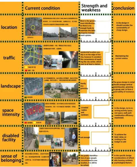
For this investigation, the current conditions of the study area related to location, traffic, landscape, space intensity, disable facility and sense of belonging have been summarized for residential environment improvement as shown in Table 1 and Figure 1. As summarized in Figure 1, RuiXian Yuan and RuiXiu Yuan are typical projects of low-rent housing built in 2005, 2006 in Tianjin, China, which locates in the suburb of HongQiao district of Tianjin. The Buildings are six-storey with each apartment 40~
50 square meters. Most of the apartments are low rent housing, mainly allocated by the department of housing management of local government to accord with a condi- tion for low-income groups. Since most apartments are constructed by the local government for low-income groups, the budget is so limited for the maintenance of the building management.
11
Figure 2-1 Low-rent Housing Existing Conditions Summary、
Table 2-1 Existing Paradigms Summary Field
investigation
Current conditions solutions
Location Most of the apartments are built by the local government distribution, there is no enough funds to maintain the building.
In the design it should consider the sustainability of construction budget and the sustainability of low-cost.
Traffic The residential location is on the edge of the city, however it considers the convenience of reaching the city centre, which next to at least a station.
Maintaining the current status
Landscape Not enough green plant in the environment Considering vertical and group greening plan to form a good performance of damage resistance
Space Features
Outdoor space is crowded, while space of inside houses is narrow, too.
Maximize the efficiency of the space, interlace the activity space, resting space, walking path together.
Disabled facilities
Most facilities in the park for the disabled and the elderly
According to the budget, at least achieve the basic standard for the special group
12
Sense of belonging
The public identification of poor people concen- trated in one location, it is still to be solved.
Beside the design, also consider housing residents psychological factors
2.4 Living needs Analysis in Low-rent Housing Residents
2.4.1 The Indoor and Outdoor Factors from the Questionnaire Survey and Interview
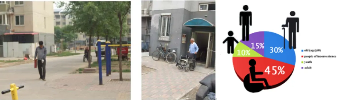
We made field survey towards this residential area, which mainly focus on the dif- ferent aspects of the living needs of their low-rent housing environment. The questionnaire follows Maslow's hierarchy of needs (Maslow, 1943) to exam different needs of the residents, which are physiological needs, social communication needs, aesthetic needs and sense of self-worth. The majority of the residents are old or disabled population (figure 2, 3), limiting to their educational level and the health condition of ageing (bad hearing, weak eyesight), they cannot not understand the questions properly. Thus, interview is chosen as a method to investigate residents’
opinions in the study area. In this survey, we have chosen 26 residents, however, the effective answers received from the residents are 11 healthy residents, containing 7 old persons and 4 youth. We try to figure out the living needs in indoor and outdoor housing space of residential environment.
Figure 2-2. (Left) The majority of the residents is old or disable
Figure 2-3. (Right)Ruixiu Yuan age structure percentage (from the service center)
Based on the investigation, most of the problems from the responder points to the insufficient indoor space and lack of outdoor space. Environmental virescence and management problems are mentioned though, they are not as strong as this issue. In conclusion, for all the users of the residential, strengthen the communication for public space is very necessary. The inconvenience of indoor function could be fulfilled by the outdoor space. In responding the calls for the communication demand, the different functional space need to be planned in the following design work.
13
As to the other responds related with aesthetic demand and sense of self-worth, which provides directions towards other aspects of the future design results (vertical green- ing, etc), we do not take it as core in this paper.
Figure 2-3. Living needs and residential environment between Indoor and outdoor
2.4.2 The Physiological Needs
Physiological demand is the physical priority demand of human being, which is also the basic requirement for a living environment. Including the fresh air, good ventilation, plenty of sunshine, suitable climate, no interference noise and so on.
The Survival Needs
First of all, the residents do have many dissatisfaction against the environment.
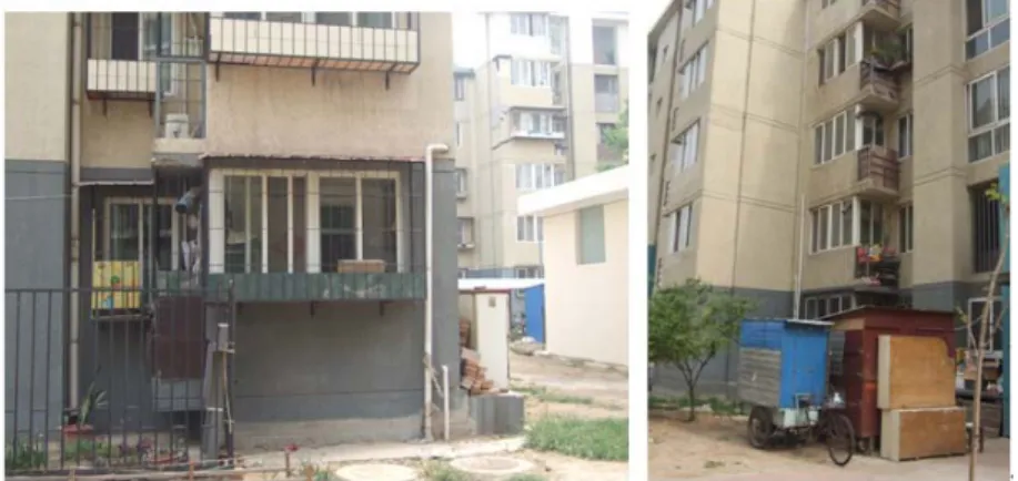
Besides the questionnaire, 10 of the 11 interview responders from residents think the problems currently concern are from the indoor.
The core problem in the local concentrates on the indoor space insufficiency, for the indoor space is where the residents actually live. In the small room fulfilled by all kinds of stuff (figure 4), the residents feel depressed for the space is barely for sitting.
And this issue influence on their communication activity of entertaining guests because of the physical impossible space, which is mentioned by more than half of the responders. The residents have no alternative towards this situation.
14
Figure 2-4. The insufficiency of the indoor space
There is no good corresponding building management, so indoor water leakage, water plugging and other problems are more highlighted. According to the interview, some of the first floors of the building always have water on the floor.
Figure 2-5. Some residents have to install another drainpipe from the second or third floor.
The Activities Needs
Activities demand stands for all kinds of outdoor activities in residential environment. In the daily life of the residents, outdoor activities may species widely, including rest, sports, recreation, fitness and targeted travel and a series of activities are required with the corresponding space environment.
In the low-rent residential house, the majority of the users are the old and the child, therefore more space for staying and activity is needed. In the interview, 7 aged people suggest that there should be more space for staying and activity. If possible, they would like to spend the day time in outdoor instead of at home watching TV.
At the same time aged persons were asked about the state of fatigue when they go out in the yard for activities. Due to personal activity preferences from different aged persons, the existing residential area has no reasonable activities for rest space,
15
according the response to this question. They are not sure after how far or how long they may fatigue. But one thing is almost the same, if they go out for purposeful activities (chat, play chess, etc.), usually they will have to bring their own small stool.
They can't stay long at standing position.
Figure2-6. (left) The residents play chess at the curbside
Figure2-7. (right) The residents need to prepare small chair to go out for rest
2.4.3 The Social Communication Demand
Whether low-rent housing settlements or ordinary residential area, the social communication demand of human activities is essential. "We believe that the residents interaction and communication is the basic foundation of city existence (John, 2007)".
In Low-rent housing, the proportion of aged people is higher than ordinary residential community, the outdoor environment can be the most important communication place for aged population since normally they will not travel long distance, so that the elderly will not segregated from the current society. However, low-rent housing every interior space is limited, thus limiting the residents indoor communication the possibility of communication. In the design of the communication activities it should have a strong sense to encourage and strengthen the communication behavior.
In addition, the need of visiting space for adults cannot be ignored. As the main group of economic source of low-rent housing families, they calls for the talks with colleagues, friends, neighbors. For less than fifty square meters of low-rent residential interior space, receiving a visitor in the home is very tight. the residents would like to have some conversation place outdoor.
Figure2-8, 2-9.There is no space to meet residents’ strong demand of communication
16
2.5 Reviewing Outdoor Design Guideline for Low-rent Housing Environment Improvement
2.5.1 Design Guideline for the Low-rent Housing Project
After analyzing the current condition of the low-rent housing residential area, we would try to redesign the environment of this area to solve the problems which are brought up by the space insufficiency. At present, the reasonable housing proportion- ing of this site is as following, which came from the calculation data of construction department:
Low-rent housing: 100,000 square meters, 2222 sets; interior space less than 50 square meters, 1 or 2 living space models; plot ratio: 3.0; greening rate: 30%; bicycle rate: 3 bicycles/apartment, and so on.
Following the indicators of outdoor space, the design and planning in study area towards the residential environment fits the requirement of the facilities, and to maximum extent shares the responsibility of interior space.
This project is subject to a high-rise residential building, tie-in part of commercial facilities and public facilities. According to the housing condition, we employed the evaluation standard in China namely Evaluation Standard for Green Building, GB/T 50378-2006. We made the examination of the outdoor space design implementation.
We employed six aspects of the standard to review this design work, which are: Land- saving and outdoor environment, Energy saving and energy utilization, Water saving and water resource utilization, Material Saving and resource utilization, Indoor environment quality, Operation management.
Preliminary judge method towards the Standard: initial determination of qualified tick “√”; the unqualified option with "X" said; the Standard provisions temporarily unable to judge a related to "?"; the Standard provisions temporary non-evaluated related with "-".
Preliminary assessment table shows as the follow tables. The standard of regula- tions down here are for the indoor and outdoor indicators, to review if the design work is qualified enough. Some of the six contents of the standard are not related to the topic of this paper, so we partly selected the relevant options from all the related standards, which are two of the six aspects.
Table 2. Land-Saving and outdoor environment
Category Standard Provision Result
17
Control opinion
4.1.1 Site construction does not destroy the local cultural relics, natural drainage, wetland, basic
farmland, forest and other reserves. √
4.1.4 Residential building layout ensuring indoor and outdoor sunshine environment, daylight and ventilated requirements, meet the national standard "urban residential district planning and design specification of GB 50180 in the residential building sunshine standard requirements. √
4.1.6 The rate of the residential not less than 30%, the per capita public green area of not less than 1㎡ √
general opinion
4.1.9 Residential public service facilities according to plan, reasonable using comprehensive building and sharing and its surrounding areas.
√
4.1.10 Make full use of old buildings. (such as the purpose of building site location in the desert, such as refuse site without old buildings open area, or old buildings in the area in 200 m ²
—
4.1.11 Residential environment noise conform to the national standard "urban regional environmental noise standard of GB 3096 regulations.
?
4.1.12 Residential outdoor daily average heat island intensity is not higher than 1.5 ℃. √ 4.1.13 Residential wind environment conducive to winter outdoor walk comfortable and transition season, summer natural ventilation.
√ 4.1.14 According to the local climate conditions and plant natural distribution characteristics, planting a variety of types of plants, constructed by combining multi-level plant, every 100 m ² green space on not
less than 3 plant trees. √
4.1.15 Location and residential gateway setting the convenience of residents to make full use of public transport network. Residential gateway to public transportation sites walking distance less than 500 m. √ 4.1.16 Residential non road motor vehicle, the ground parking lot and other hard floor using permeable ground, and the landscape to provide shade. Outdoor permeable surface area ratio is not less than 45%. √
Table 3. Indoor environment quality
Category Standard provision Result
Control opinion
4.5.1 Each house has at least one living space to meet the requirements of the sunlight. When there are four and four more living space, there are at least two living space to meet the requirements of the sunlight.
√
4.5.2 Bedroom, living room (hall), study, kitchen set up outside the window, the daylighting of the room coefficient is not lower than the national standard "architectural lighting design standard of GB 50033 regulations.
√
4.5.4 Living space can natural ventilation, ventilation openings in hot summer and warm winter area of hot summer and cold winter area is not less than 8% of the area of the room floor, in other areas is not less than 5%.
√
4.5.5 Indoor free formaldehyde, benzene, ammonia, radon and TVOC and air pollutant concentration accord with the national standard "civil building indoor environment pollution control norm" GB 50325 regulations.
—
4.5.10 By the adjustable outer shading device, prevent summer the sun radiation through the window
glass directly into indoor. ?
Optimization 4.5.12 Bedroom, living room (hall) use energy storage, humidity or improve indoor air quality
functional material. (design stage this not eligible) —
After reviewing the standard, we have a clear idea towards which parts of the low- rent housing problems the design may cover and towards which parts may be hard to
18
improve by only redesign the environment. In next section, we will present the detail methods of this environment design.
2.6 Low-Rent Housing Environment Improvement For Indoor Space Insufficiency
In this section we try to redesign the environment to solve the main problems of space insufficiency of the low-rent housing to lower the cost of the reconstruction.
Low cost and high performance as far as possible is the key task of this project. Some of the design guideline related to indoor and outdoor environments are as follow.
Considering community supporting commercial facilities construction, increasing the proportion of business and other service facilities. Arranging more residents’
employment in this area, to improve the low-income people living and working condition.
Considering the service facilities of the community, focus on convenience of the public service. While meeting the requirements of planning and design, the health services, public security, education and other functional service facilities may moderately increase. Make full use of the first floor space of the building, combining with the landscape design and public service.
The needs of different age class should be taken into consideration carefully in landscape design. The open space of public activities should be combined with relatively independent group greening, such as: the children activity space, the fitness equipment playground. Differ from commercial residential design, the design concept should aim to sustainable development and low maintenance.
2.6.1 The Interlaced Functional Outdoor in Guideline
Based on the discussion in the last session, low-rent housing, with the major group of the old and disabled people, should provide sufficient stay space, activity space for the incontinent people,to meet their demand of living and communication.
Therefore, in the environmental planning,the landscape design should not have large distance non-staying green belts. First, in order to ensure the old people’s rest.
Second, avoid large area of green plant of high maintenance. Third, avoid the
"enclosure behavior" which mentioned in the previous section. These thinking about
19
indoor and outdoor has been put into the design principle and shown as Figure 2-11, 2-12.
Besides the aged people, the youth is at the second place of the priority. Although children activity facilities are differ from the old, however the safety precautions of the activity space are similar. Thus, in the design, we can combine the activity/stay space and children activity space together, scattering as different space in the area.
This kind of layout scheme shown in Figure 4 sacrifices large area of landscape view. But from the residents' psychological need, the actual maintenance costs, and the convenience of functional space, it has the high cost performance.
Figure 2-11.(left)The interlaced pattern of functional outdoor Figure 2-12. (right)The planning ichnography of different space functions
Figure 2-13. The example of interlaced functional outdoor
2.6.2 The Establishment of the “Private” Yard in Guideline
In order to make up for the space deficiency of the function of sitting room indoor, some half-closed private space is necessarily established in the residential district, which is equivalent to transferring the indoor function to a courtyard space for receiving visitors.
The spatial arrangement of the private yard is next to each entry of the residential area for convenience, which are several half-closed places for conversation and
20
discussion. It avoids the main road , as well not be interfered by the traffic. In the space division, trees and shrubs are the soft isolation belt, which are 0.8m to 1.3m height, to provide the conversation privacy relying on the environment. In this way the sitting room function is moved to the outdoor environment, letting the individual communication happen in a big environment, promoted the neighborhood relationship.
At the same time the space also as one of scatter space, achieves a variety of functions for old peoples' rest.
Figure 2-14. The example of the “private” yard
Figure 2-15. The pattern of space formation
2.6.3 Public Space Design for Indoor Insufficiency
We try to provide a comprehensive consideration of the public activity space and walking system Settings. Public space environment design should pay attention to the resident age characteristics and behavior pattern. Outdoor fitness equipments are necessary for residents to exercise and children to play. Service facilities, including but not limit to public gathering place, the elderly and children activities places and community health, are of the importance. And disabled moped, small tricycle parking Spaces and accessible elevators should be set.
The square of the central area or the main entrance can be planted around shade trees, and set rest seat, provides the rest, activities, communication facilities for the residents, partly equivalent to transferring the indoor function outdoor. Hard pavement with permeable material is given priority to, and it should take anti-sliding measures.
21
In the design of landscape full consideration should be taken for the needs of every age class. The activities of the public open space group combination of greening plant should be designed together.
2.6.4 The Outdoor Environment Design Review Summary
Table 4. The environment design review result Evaluation
Standard for Green Building Star Level
Options of the standard (in total 31) Land-saving
and outdoor environment
(7)
Energy saving and
energy utilization
(6)
Water saving and water
resource utilization
(7)
Material Saving
and resource utilization
(7)
Indoor environ- ment quality
(7)
Operation management
(7)
★ 3 2 3 1 2 1
★★ 4 3 4 2 3 1
★★★ 5 4 5 2 4 1
The numbers of the result of the design project which meet the standard Eliminate
the dubious options
4 3 6 4 4 2
Including the dubious
options
6 5 6 4 6 2
The upper part of Table 4 is the judgment criterion of Evaluation Standard for Green Building. The number under each category of the six aspects of the standard shows the options considered in total (e.g., Land-saving and outdoor environment, 7), and the number met the individual regulation can be evaluated as different star levels from one star (★) to three star (★★★).
The lower half of Table 4 is the examining result of the design work according to the original scale adjustment. According to the GBT50378-2006 clauses 3.2 regula- tion: when a standard provision does not adapt to the construction area, climate, building types or conditions, which doesn't participate in review. At this time, the total number of a contestant will be reduced correspondingly. In the table of evaluation summary, eliminate the dubious options, the result of the design matches the two stars standard; including the dubious options, the design matches three stars standard.
Especially, In the evaluation of Land-saving and outdoor environment and Indoor environment quality, including the uncertain options, the environment outdoor design of the low-rent housing environment get the 3 stars standard, which provides the
22
convincing evidence the outdoor space is improved and the design methods we used in the paper is a positive alternative.
2.7 3D model Helps Representing the Guideline
Figure 2-16. The 3D environment of the design concept of the area
With the help of 3D model technology, it is much easier to review the indicators of a design project, as well as the comprehension to the project for the first party. In this section we use the regulations of Land-saving and outdoor environment as example to explain how the 3D models facilitate representing the design guideline.
23
Figure 2-17. The sunshine shade simulation
In the option 4.1.4 of the previous form, the standard has the requirement of the necessary hour of sun light. Use the 3d model of the design project and the relevant software, it can bring the daylight levels of the whole area clearly to the stakeholders.
Figure 2-17. 3D vertical greening group of plant configuration
For the option 4.1.14, the requirement of planting a variety of types of plants, 3d model shows a intuitionistic virtual presentation. In this shoot, the audience can view the plants configuration and greening method of the design document straightly.
Figure 2-18(left). 3D environment of the entrances of the residence area Figure 2-19(right). The 3D rest yard model
24
Without doubt, 3D model also has its natural attribute that this technology is advantageous in representing architecture environment with a virtual image, which shows in the figure 18 and 19, towards the option 4.1.15 and 4.1.16.
2.8 Conclusions in this Chapter
The contribution of this research is to explore an alternative to solve the indoor space insufficiency of low-rent housing for developing sustainable housing scheme at low cost. This research may help the housing department of the government consider which elements of the environment may have a high performance meanwhile keeping an acceptable quality for the residents.
Instead of designing the building, this thesis addresses the point that by reorganiz- ing the residential environment to shift some insufficient indoor function to the outdoor space, achieving the improvement for the low-rent housing. On the one hand it lower the pressure of the high density of the buildings, on the other hand it is easier to implement than rebuilding the whole area for the residential improvement. We hoped that from the result of this research a noticeable low-rent sustainable house design scheme could be taken into consideration and maybe implemented for the increasing needs of the households in the country.
With the using of 3d model to present the guideline to the first party, the concern of Chapter 2 is to design towards the development of critical construction processes in residential environmental design for developing affordable and sustainable housing scheme.
Additionally, if greening consciousness being involved in the implementation, it may cause positive effect in keeping life cycle of the sustainability and stability of the environment. We will try to explore other alternatives with acceptable finical budget in order to help low group income to own the durable housing as well as the environ- ment. The work done so far was the preliminary attempt, and the future work shall be focus on the specifying the detailed design standards for affordable housing, if
possible.
25
Chapter 3 : Using virtual global for
Representing Design Guideline of Urban Environment
3.1 Introduction
In this work, we employed Google Earth as a web-based visualization tool to rep- resent planning and design guidelines of an urban planning site to improve the presentation of planning alternatives for the nonprofessional public understanding and design coordination with stakeholders. Public participation is very significant through the design coordination process of any urban planning or design project, for all the projects are finally to become part of the public’s daily lives (Kingston, 2000; Tiedtke, 2005). It has been proven that one urban planning project is more likely to succeed if the public have more opportunities to get involved. Some public participation in the planning process is a political goal in European countries (Hetherington, 2007).
In European countries, local governments are more and more required to make the data of urban planning available digital over the Internet (Märker, Pipek, 2000). Soon It has been proven that to promote public involvement during the urban planning procedure using the computer science by conducting the interactions with planners and the public (Lai, 2010). Undoubtedly the internet become a great platform to share the information and assemble the comments. Traditionally, the communication of planning proposals between the planners and public was in the help of the drawings, sketches, text and other methods during the planning meeting. Some urban planning tools such as computer design and geographic information systems have provided the function of planning designs to export as searchable maps, digital drawings, label and other supplement files. The conventional methods above cannot offer sufficient ways for users to experience all of the aspects of the planning sites. Virtual reality (VR) can also be used to represent planning sites on the Internet as reference material for stakeholders. Now as the developing of virtual globe technology, a multi-function 3D visualization platform is capable to be created for sharing the urban panning data with the general public. Not only the professional designers but also the nonprofessional stakeholders can operate the proposed project of the site (Wu, 2010)
26
Many studies are currently researching applications of VR systems using Web technology for planning support. In the past ten years, although designers mostly used drawings and planning sketches in business, some of them have gradually adopted virtual reality technology to facilitate citizen understanding of the content of urban design guidelines, visualize more design concepts and better design details, and provide greater fun in this field (Shen, 2003). Shen et al. (2010) also completed a WEB VR system simulating the district landscape of Nanao City. The Urban Planning Exhibition Hall in Expo’ 2010 in China represented the significant simulated system of VR to exhibit the urban design guidelines of Shanghai to the public and citizens so that the people can interact with each other in it, share their experiences, and leave their feedback (Gao, 2010; Styliani, 2009). In addition, stakeholders can discuss among themselves or with the designers about the virtual world of the city provided by the VR system (Masatoshi, Takafumi, 2008) through the Internet.
In the planning process, designers can attempt their thoughts more accurately and specifically using a VR system on the internet. It is possible to enhance public partici- pation through the effective communication processes as well. As discussed above, the virtual model is effective at improving the information flow and knowledge to the public (Jiang, 2003). On the one hand, stakeholders without a professional back- ground in planning or design can also learn the content of the urban planning and post opinions. On the other hand, designers and planners can improve their design works based on feedback from the stakeholders.
During the last few years, 3D virtual reality technology in cloud-based system has become matured and public have get more used to the virtual globe technologies. The public can use their home computers and access the virtual globe through the Internet, which provides the public a new communication platform and allows public participa- tion in planning process, from brainstorming of the idea to the final completed project (Drummond, 2008). Virtual globe system has become popular with the general nonprofessionals. It is predictable to use virtual globe technology for urban planning information sharing in the future.
Google Earth is virtual globe software and a new potential system with some func- tions similar to a VR system. As a three-dimensional globe, Google Earth includes all the cities of the world. It is difficult for a conventional VR system to share VR datasets of different cities in the same virtual world (Meguro, 2003; Hamilton, 2001).
Google Earth, which was released in 2005, is now widely used by the general public
27
and researchers. (Wu, 2010) discussed the technical issues of programming a virtual globe-based system framework for promoting GIS information and data using web services, or service-oriented architecture to facilitate the 3D model visualization and sharing with Google Earth. Although Google Earth has potential with regard to planning practices (Lee, 2007), so far there have been only a few reports on the improvement of public participation during planning process using Google Earth.
Thus, we address utilizing the functions of Google Earth for public participation in planning practice by illustrating more planning and design guidelines.
In this work, we employed Google Earth as a visualization tool to represent plan- ning and design guidelines of an urban planning site in order to improve the presentation of planning alternatives for public understanding and design coordination with stakeholders. We attempted to employ Google Earth to improve stakeholders’
understanding of urban design guidelines compared with conventional planning documents and drawings. Section 2 describes the research approach details. Section 3 discusses how to represent design guidelines using Google Earth. In Section 4, we give conclusion of this chapter.
3.2 Research Approach
The present work examined Datong Newtown, China, as an example of typical planning guidelines for the Newtown development project in China. Our study did not consider details on developing the urban design guidelines; we used the proposed guidelines to visualize the planning concept in this area.
The urban design guideline concept in China originates from detailed urban plan- ning and design in the 1980s. In order to solve problems with rapid urban expansion and construction during this time, some regions in China began to emulate foreign city designs to produce the roots of the guidelines (Gao, 2007). Nowadays, the content of the guidelines is relatively complete and contains the following main 11 aspects:
building style and special features, urban land use, urban integral space pattern, public green space system, urban landscape system, historical culture protection and utiliza- tion, urban road space, urban activities and support, architectural and environmental space, key area, and incentives (Kong, 2007). All 11 aspects are part of the compre- hensive urban design guidelines in China.
28
In contrast to a VR system, the Google Earth platform shares a database of infor- mation from around the world; we can visualize an urban project over the entire globe and not just within the limited project area. This feature makes Google Earth inherent- ly superior at expressing and sharing urban design guidelines of the world, which aid stakeholders’ understanding by comparing different projects in the virtual world. We utilized Google Earth to represent some urban design guidelines in the Datong region to reveal how efficient it can be to visualize the documents. The whole work com- prised three components. First, we proposed urban design guidelines that were developed for the Datong region and discussed the flexible application of Google Earth. In this step, we examined existing urban design guidelines to determine the content for visualization. Second, we discussed how to use Google Series software to visualize the design guideline. Third, we used Google Earth to test our dataset. In the future, it will be necessary to open up the dataset to stakeholders and collect their feedback on the effectiveness of representing urban design guidelines using Google Earth. We did not discuss user feedback at this stage.
The guidelines for Datong Newtown chosen in this research focus on natural envi- ronment protection for sustainable development. Therefore, our work on visualizing this urban design guideline involved environmental design guidelines and conven- tional urban design guidelines, including those for construction, road networks, and land utilization. In order to utilize the multiple functions of Google Earth, we tried to fully utilize the superiority of multimedia to express the urban design guidelines and replace vague parts with our new explanations.
Using Google Earth to download 3D GIS topography
Google Earth is 3D GIS software; it is rich in geographic information presented in map formats, and its virtual three-dimensional version was originally called Earth Viewer 3D. It maps Earth by overlaying images from the satellite imagery, aerial photos, and three dimensional global (Phan, 2010). Fetching 3D GIS topography is as well possible as a basement to create a virtual city model using Google SketchUp.
Using Google SketchUp to produce a 3D model
Many city models already exist in Google Earth. After editing these models on downloaded topography, we can use Google SketchUp to upload them onto Google Earth (Lee, 2007).
29
Adding conventional multimedia such as text, images, and links of cities in Google Earth as references
For some guidelines that are hard to express with a 3D model, we can use texts and charts to add them directly to Google Earth. We can then add conventional multime- dia such as outdoor scene photos, audio files, and movie clips along with other information to present the design guidelines in Google Earth.
Using this method, we can have all kinds of multimedia, such as text, images, and photos, to support 3D models that represent urban design guidelines in Google Earth.
We can involve all of the previous media in the platform for Google Earth. The completed Keyhole Markup Language, Zipped (KMZ) file format can be used for browsing, watching, commentary, and modification as long as users have a computer with Google Earth software and are connected to the Internet.
Testing and application of urban design guidelines
There are two conventional methods to show urban design guidelines using this system: showing them to the stakeholders with a projector or touch screen and pub- lishing them through the Internet.
Google Earth has a 3D model database called the Google 3D Warehouse platform.
There are many models and information in it about all of the cities’ architecture and scenery. Although it has not been verified, it might be one of the biggest free building 3D model databases in the world. Architects and planners update the models and related information in the database every day. The completed Google Earth database can be shared with users around the world on this platform.
3.3 Using Google Earth to Express Urban Design Guidelines in DaTong Region
For Datong Newtown, we reveal three detailed guidelines using Google Earth:
traffic, architecture, and environment guidelines. By combining the three guidelines in Google Earth, the space appears more realistic and is easier to understand than reading documents and drawings on each guideline independently. This effect is discussed in the following subsections. The guidelines presented in our work are not the proposed planning guidelines by the campaign planning teams in the local design
30
competition organized by the local government. In the local design competition, most design guidelines come from Western countries; thus, the guidelines utilized in this work are not based on the Chinese planning system.
3.3.1 Traffic Guidelines
Topography map for site layout and traffic network
All of the content for our design guidelines comes from New Design Guidelines—
A Step towards Self-Explaining Roads (German Federal Transportation Research Institute), in which urban roads are divided into 21 different types according to cross- sectional constitution, intersection form, road corner radius, largest cubes, and special use form. In this study, we divided all of the main roads in the Datong region into five types and visualized them in Google Earth. The overall topography map and traffic network map are shown in Fig. 1. To present the planning document of road types, a picture in the 3D world of Google Earth is embedded in the bottom left corner of Fig.
3-1.
Figure 3-1. Traffic guidelines for urban traffic network in Google Earth
The urban design guidelines were developed based on a site plan using topography maps, which is intuitive for illustrating the design requirements of the entire site layout. Thus, we need to add the site planning as an overlay to the topography map in
31
Google Earth. Topography maps are characterized by being always extremely close to the ground and undulating. We used the image overlay adding pattern from Google Earth to directly overlap fabricated images onto available topography conditions in Google Earth; this is easier than the expression in a VR system.
Details of all types of urban roads—3D model and combination of texts and charts
In the previous VR system, the 3D model can be shown with related papers and html links. However, Google Earth can use its connecting mechanism to place the 3D model and related materials together and promote stakeholders’ understanding through reading and listening.
Table 3-1 presents the 3D models of sample roads and detailed illustrations with texts and charts. The 3D models in Google Earth are easier and more straightforward to be understood than is the traditional combination of texts and charts when design- ers explain the planning materials of traffic networks. More pictures of the road section and plane can be added as auxiliary information, as shown in Table 3-1.
Google Earth uses real-time rendering technology, so the datasets of the 3D model can be changed instantly. Either VR or virtual globe changes the vision angle freely, and the 3D model’s datasets can be changed conveniently. Designers can change the vision angles freely during the model-making stage, and animation and rendering can be done after the designer fixes the vision location or vision route. Google Earth can display any angle from the model-making stage to the final exhibition stage. Although it is not easy for the stakeholders themselves to create the models, designers can now import enough sets of 3D data into Google Earth according to current regulations for urban design guidelines. As the [Road type 1 3D model in summer/autumn in Tab.3- 1], users can exchange datasets and show the urban image for different road types;
this allows stakeholders convenient access to the correct information on different road types in the design guidelines.
Table 3-2. Traffic guidelines in Google Earth Road types The road types of Traffic Guideline in Google Earth
32
Road type 1 3D model in Summer /autumn
Road type 2 3D model
Explana- tion for Road types
Planning documents for road design embedded in the 3D world of Google Earth
Road type with planar graph and section drawing
The traffic guidelines reveal a completely new exhibition effect embedded in the 3D world of Google Earth. An analysis table is presented on the effectiveness of Google Earth at representing traffic guidelines. As shown in Table 3-2, traffic guide- lines received an “effective” result. This means that more than half of the guidelines