Introduction
Ino¯ Tadataka (1745–1818) compiled the first map of Japan that relied on scientific surveying methods. Ino¯’s map, published after his death in 1821, was the result of some 40 million steps that enabled him to carry out meticulous surveys of the vast geographic space that made up Japan. His first steps took him from his home in Sawara (Chiba Prefecture) to Edo in 1795–at the age of 50. There, studying at the Tokugawa government’s Bureau of Astronomy, Ino¯ mastered astronomy, calendar science, mathematics, geography, cartography, and Western surveying technics. His first survey, in 1800, took him to Ezo in a quest to calculate the exact length of one degree of the earth’s latitude. When he completed his travels in 1816, Ino¯ had amassed a huge geographical archive, a treasure chest of environmental knowledge that including precise calculations of distances, altitudes, and the latitude and longi- tude of the entire country.
What sparked Ino¯’s determination to know and measure the physical environment of Japan and to locate it so precisely on planet Earth? What tools and techniques did he use? What is the legacy of the environmental knowledge he compiled? Ino¯’s project epitomized “knowing by going.” With compass, clock, sextant, and telescope in hand, he examined the land and measured his steps by day; he observed the skies to determine his latitude by night. I argue that Ino¯’s 40 million steps resulted in new forms of environmental knowledge. It was Ino¯’s genius and stamina that helped to transform Japan from a beautiful but unmeasured space into a knowable landscape that could be accurately and comprehensively reproduced on paper.
1)Ino¯’s walking feats compare favorably with other late Edo period travelers de- scribed by Marcia Yonemoto, Laura Nenzi, Mary Beth Berry, Constantine Vaporis, and other scholars who attribute travel to the development of a culture of mobility and the “discovery of Japan,” the growth of a national consciousness, that expanded the fund Japanese environment and cultural knowledge.
2)Ito was part of this en- deavor–but even though the prime meridian he constructed ran through Kyoto, Ja- pan’s imperial capital, his was not an excursion in national identity, nor was his
“mapping of Japan” the broad imaginary and discursive spaces described by Marcia Yonemoto and others. Nor were his walks, like those of Murao Karyo¯, undertaken
The Man who Walked 40 Million Steps:
Ino¯ Tadataka and the Modern Mapping of Japan
M. William Steele
measured each step he took and took note of geographical features such as moun- tains, rivers, lakes and islands and at regular intervals throughout Japan calculated the latitude, longitude and elevation of that particular place not only in Japan but on the planet earth. And while Ino¯ clarified where Japan is and is not, his feats of walking and surveying were continually seeking to answer a very personal question:
where am I?
Ino¯ Tadataka–a unusual life story (1745–1818)
Ino¯ was born in 1745 into a family of well-to-do fisherfolk in the Kuju¯kuri coastal area in what is now Chiba Prefecture.
3)As a youth he worked with fishermen taking care of nets and tackle. He is said to have been interested in astronomy and mathe- matics from age 12, but more likely his early education was in the school of hard knocks, learning the importance of hard work and self-reliance. At the age of 17 he was adopted into the Ino¯ family in nearby Sawara–a once prosperous family en- gaged in rice, sake brewing, and money lending. He worked tirelessly to restore the family’s fortunes, and by the age of 30 (1775) was able, like other members of Japan’s rural elite, to engage in scholarly pursuits, including a study of the classics and the composition of Chinese and Japanese poetry. In the Tenmei period–the 1780s–
serving as village headman, he succeeded in easing the ill effects of famine, floods and epidemics that so damaged many parts of Japan. From 1790 he was able to re- lax and turn over most the running of the family business to his son. It is from this time that he began to take up the amateur study of astronomy and mathematics, reading the Li-xiang kao-cheng (Compendium of Observational and Computational Astronomy), written by Jesuit scholars in Chinese, published in 1723 in China but only available in Japan from the 1760s. He also had the leisure to travel. In the spring of 1793 he set off on a three-month journey to visit Ise Grand Shrine and oth- er historical and famous places along the route. He travelled along the Tokaido¯ on his way to Ise and returned by the Kiso route. According to his biographers, his travel journal was already exceptional for his scientific approach to observation.
“When he came to a beautiful place, he took out his pocket magnetic compass and roughly determined the azimuth of each spot and he studied the natural features of the locality; and when the sky was clear enough at night he determined the latitude by roughly measuring the altitude of the North Star.”
4)His diary was thus filled with numbers and the results of scientific observations rather than poetry reflecting on the beauties of nature.
In 1795, at the age of 50, he formally turned over the family business to his son.
Set free, he determined to take up residence in Edo and devote himself completely
to the study of astronomy and mathematics. The extent of this rural merchant’s un-
derstanding of astronomy, mathematics, and the science of land-surveying must
have been impressive, for he was granted permission to study under Japan’s leading
astronomer, Takahashi Yoshitoki, who had, in 1795, been appointed head of the
Tenmongata, the bakufu’s Bureau of Astronomy. Born in 1764, Takahashi was near-
ly 20 years younger than his new–and most famous student.
Ino¯ spent the next five years in Edo becoming familiar with the most up-to-date theories of astronomy–reading the sequel to the Chinese Compendium of Observational
and Computational Astronomy (published in 1743 but available in Japan from the1780s); it included an explanation of the elliptical orbits theory of Kepler–showing China and Japan both about a century behind Western advances in astronomy, but catching up quickly. Takahashi, for example, was engaged in translating the Astro-
nomia (published in Japanese in 1803), a text by the French astronomer Lalanda pub-lished in 1780. These were years of study and of practice. Using his own money, Ino¯
purchased or order-made advanced measuring instruments, including telescopes, magnetic compasses, magnetic theodolites, quadrants, pendulum-clocks, transit-in- struments, eclipsemeters, and instruments to measure the sun’s altitude. He converted his house in Fukugawa Kuroe-cho¯ into a private observatory–this became the headquarters of his later work in surveying the entirety of Japan–and it rivaled the shogun’s official observatory in Asakusabashi. In both places Ino¯ spent time mak- ing celestial observations and calculations and gained considerable reputation as an astronomer. His nickname was suiho¯ sensei–master of computations.
There was keen competition among astronomers in the eighteenth century to de- termine one’s particular location–we call it today a “global position.” Accurate cal- culations of longitude and latitude was necessary for cartography and navigation.
Figure 2: Ino¯ Tadataka’s quadrant used to measure latitude Courtesy of the Ino¯ Tadataka Museum, Katori City, Chiba, Japan
Figure 1: Portrait of Ino¯ Tadataka
Courtesy of the Ino¯ Tadataka Museum, Katori City, Chiba, Japan
tude presented problems, especially at sea. In 1714, a prize was announced by act of Parliament in England, offering 20,000 pounds for anyone who could determine lon- gitude within half a degree in accuracy.
5)Nowadays it is possible to instantly deter- mine location, latitude, longitude and elevation/altitude. But in the eighteenth and well into the nineteenth century, such calculations were a time-consuming project.
Even after the prize was issued in 1777, astronomers worldwide continued to seek new solutions. Perhaps this worldwide competition lay behind Ino¯ Tadataka’s desire to calculate latitude and longitude coordinates (allowing him to know the exact spot on earth on which he stood) but also determine accurately the length of the earth’s meridian–and thus be able to accurately calculate the size the planet earth. He sought to do so by observing the position of fixed stars from two different points. To this end he measured the distance between his observatory in Kuroe and the Tokugawa observatory in Asakusabashi, the two points being some 2.9 km apart.
When he reported his project to Takahashi, he was advised that such a project–to determine the earth’s magnitude–needed to be carried out on a much larger scale.
This was the origin of the project Ino¯ carried out over the next 18 years with the aim to survey all of Japan, beginning with a survey expedition to Ezo in 1800. When he returned from this first expedition, he was able to calculate the length of one degree of the meridian arc to be 106 km; later after some 2,000 measurements of latitude, he was able to agree within several tenths of a second of a degree with the figure given in the Lalande’s Astronomie. And by the end of his surveys in 1817, just before his death, he was able to refine his calculations, determining that one degree of latitude to be 110.75 km, and the perimeter of the Earth to be 39,870 km, only 0.58% off the correct value. With satisfaction, finally, he was able to answer the question: “where am I”?
6)Figure 3: Hokusai, Fuji at Torigoe, from One Hundred Views of Mt. Fuji
Astronomers working on the roof of the Tokugawa Observatory, near Askusabashi.
(public domain)
3,376 days on the road (or 43,708 km later)
In order to determine the earth’s magnitude, Ino¯ sought to carry out a survey of latitudes and longitudes between Edo and Ezo (Hokkaido). Such a project, even self- funded, nonetheless required official permission. In 1800 he made such application:
“Now that I have studied day and night for six years as a pupil of Takahashi Yoshito- ki, I am able to make measurement without error. To that end, I have collected vari- ous instruments and expended more money than would befit my position. I wish to make maps that might serve as reference to coming generations. To make a survey with measuring-poles and measuring-ropes and carry about large instrument within the territories and estates of the daimyo and immediate vassals of the shogun will undoubtedly provoke a challenge from the government officials.”
7)Given the grow- ing sense of threat from Russian ships appearing in northern areas of Japan and Ezo, the shogunate agreed to sponsor the project of this 55-year old rice merchant–
the mention of map-making especially drew their attention.
On the morning of June 11, 1800, Ino¯ took his first steps in a survey expedition to Ezo–the first of ten surveys that he would undertake over the next 17 years in order to survey Japan’s entire coastline and its major roads. In his first survey he was ac- companied by his second son, two astronomy students, two servants, and two hors- es. Over the years, as the Tokugawa government came to appreciate the accuracy and strategic importance of the maps he produced, the expedition grew in size and in official recognition. In the end, Ino¯ spent some 3,736 days waking covering some 39,000 km–about the same distance as walking around the world.
Ino¯’s
Age Trip Destination Depart Return Days Distance
(in km) 56 1 O¯shu¯ Kaido¯ to Ezo 1800.6.11 1800.12.7 180 3,223.89
57 2a Sagami Izu 1801.5.14 1801.7.16 64 572.29
57 2b Honshu¯ East Coast 1801.7.29 1802.1.10 166 2,550.09 58 3 Uetsu Northwest Coast 1802.7.10 1802.11.18 132 1,701.04 59 4 Chu¯bu East and West 1803.4.16 1803.11.20 219 2,176.63 61–62 5 Southwest and Kii 1805.3.25 1806.12.24 640 5,383.15 64–65 6 Shikoku and Ise 1808.2.21 1809.3.3 377 3,442.67 66–67 7 Kyushu (1) 1809.10.6 1811.6.28 631 7,005.97
67–70 8 Kyushu (2) 1812.1.9 1814.7.9 913 11,530.49
71–72 9 Izu and Islands 1815.6.4 1816.5.8 340 1,200.62 72 10 Edo city streets 1816.9.29 1816.12.11 74
Totals 3736 38,787.84*
Chart 1: Summary of Ino¯ Tadataka’s 10 survey expeditions Source: InoPedia
*43,712.41km total including auxiliary survey squads
In addition to Ino¯’s personal diary (consisting of 28 volumes) that detailed obser-
gathered, including distances, elevations, azimuths of mountains and islands, latitude and longitude readings, celestial observations, tables of sunrise and sunset, solar and lunar eclipses, and occultations of Jupiter’s four moons. These records, stored in the archives of the Ino¯ Tadataka Museum in Sawara, are a source of unrivaled quantita- tive information for students of pre-modern Japanese geographic and environmental history.
8)A prime example is Ino¯’s scientific survey of Japan’s most sacred moun- tain, Fuji. He calculated the height of the mountain to be the equivalent of 3,732 m (compared with the actual height, 3,776 m).
Ino¯ also played the role of pilgrim and tourist on his travels; he mapped routes to famous places, and stopped to admire the view and offer prayers at temples and shrines along the way. For example, returning from his sixth expedition, the 1808–
09 survey of Shikoku, from Osaka he took the Yamatoji post road to Nara and across the Kii peninsula to Ise, arriving at the Grand Shrine on New Year’s day, 1809. Along the way he offered prayers at Taima-dera and viewed its treasures, in- cluding the Kasuga mandala, and proceeded half as a pilgrim to Ho¯ryu¯ji, Ho¯rinji, Ho¯kkiji, Yata-dera, Yakushiji, To¯sho¯daiji, Saidaiji, Akishino-dera, To¯daiji (Great Buddha), Kasuga jinja, and so on visiting famous spots in Asuka and Yoshino before making his way the Ise Grand Shrine. His maps were thus not only of strategic value, but in popular versions served as tourist guides, showing the exact route and distances involved to the entrances of temples, shrines and spots of special natural beauty.
Conclusion
Ino¯ died in 1818; his grave is beside that of his teacher, Takahashi Yoshitoki who died in 1804.
9)Ino¯ was 73 years old. The land survey had been completed but the work to compile maps was entrusted to his pupils. The collection of maps that made up the Complete Maps of Japan’s Coastal Areas was presented to Tokugawa authori-
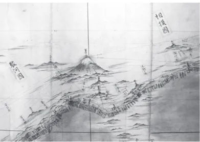
Figure 4: Medium-scale map of Mount Fuji Area Courtesy of the Ino¯ Tadataka Museum, Katori City, Chiba, Japan
ties in 1821. It included projections of 1) 3 small-scale maps (section maps of Hok- kaido, eastern Japan, and western Japan. 2) 8 medium-scale maps (western Hokkaido, eastern Hokkaido, Northeastern Honshu, Kanto area, Chubu area, western Honshu and Shikoku, northern Kyushu and southern Kyushu). And 3) 214 large-scale maps of sections of all of Japan.
10)In all, it remains a remarkable feat of cartography and succeeded in representing the country as a whole (as opposed to previous mapping enterprises that took the various provinces as basic units). The impact of the maps themselves was muted. The Tokugawa government treated the maps as secret docu- ments and prevented them from, until the end of the Edo period, from reaching the wider pubic. Nonetheless, the maps and their construction are a tribute to the ge- nius and stamina of an outstanding Edo period individual, determined to locate his particular position on planet earth. At the same time, however, in an age of growing nationalism, Ino¯ Tadataka was a globalist. His maps spoke the universal language of cartography; in fact, copies of his maps smuggled out of Japan were quickly rec- ognized worldwide as the most authoritative maps of Japan. Even after the Meiji Restoration, Ino¯’s maps were used as the standard self-representation of Japan until the 1920s.
11)Aside from the fund of environmental knowledge compiled by Ino¯ during his sur- vey expedition, Ino¯ has left two other important legacies. Indeed, Ino¯ Tadataka is one of the most well-known historical figures in Japan today. First, for the remark- able accuracy of his mapmaking. Second, his life story has proven inspirational, es- pecially for Japan’s growing population of senior citizens. He went back to school at the age of 50 and then embarked on a second career–doing what he always wanted to do and making his dreams come true. He spent 17 years of hard work surveying
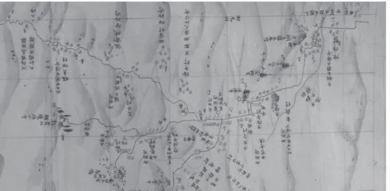
Figure 5: Large-scale map 135, Yamatoji Post Road, Osaka to Horyu¯ji section
○ post station | astronomical check point / Lines indicate the survey route Courtesy of InoPedia
foundation of modern cartography, but for his stubborn individualism, his global- ism, and his determination to learn and do new things. And finally, Ino¯ contributed to a now well-established culture of walking in Japan. Known as the man who walked 40 million steps, his example has inspired others to follow in his footsteps, for simple exercise, but also for the spirit of “knowing by going”–by walking as a form of exploration and learning about one’s environment. The Shinkansen is a
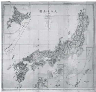
Figure 6: 1878 Map of Japan based on Ino¯ Tadataka’s Surveys (public domain)
Figure 7: Ino¯ Tadataka statue, near his house/observatory in Edo (Fukugawa, Kuroe-cho¯; present-day Monzennaka-cho¯). Photograph by the author.
symbol of modern Japan, but so is the statue of Ino¯ Tadataka, walking with a deter- mined stride. In Japan it is possible to download an Ino¯ Tadataka walkmeter that will tell you how many steps you have made–and give you encouragement along the way. There is even an InoPedia app showing all the places where Ino¯ spent the night on his survey trips and if you are within 500 meters of one of them, a Google map will lead you to the spot.
Notes
1) This paper is based on a presentation given the East Asian Environmental History Conference held in Tianjin, China, October 26–31 in a panel entitled “Knowing by Going.”
2) Recent books concerned with Edo period travel and travel literature include: Laura Nenzi, Excur- sions in Identity: Travel and the Intersection of Place, Gender, and Status in Edo Japan, Honolulu: Uni- versity of Hawai’i Press, 2008; Mary Elizabeth Berry, Japan in Print: Information and Nation in the Early Modern Period, Berkeley: University of California Press, 2006; Marcia Yonemoto, Mapping Early Moden Japan: Space, Place, and Culture in the Tokugawa Period, 1603–1868, Berkeley, University of California Press, 2003; Constantine Vaporis, Breaking Barriers: Travel and the State in Early Modern Japan, Cambridge, Ma.: Harvard University East Asia Center, 1995; and essays in Kären Wigen, Sugimoto Fumiko, and Cary Karacas, eds, Cartographic Japan: A History in Maps, Stanford: Stanford University Press, 2016.
3) Biographies of Ino¯ Tadataka include: Ryokichi Otani (Kazue Sugimura, trans.), Tadataka Ino¯, The Japanese Land-Surveyor, Tokyo: Iwanami Publishers, 1932, reprint edition: Safety Harbor, Fl: Si- mon Publications, 2001; Hoshino Yoshisa, Ino¯ Tadataka: Nihon wo hajimete hakatta guchoku no hito, Tokyo: Yamakawa Shuppansha, 2010; and Watanabe Ichiro¯, Ino¯ Tadataka no aruita Nihon, Tokyo:
Chikuma Shobo¯, 1999. For bibliography of works on Ino¯ Tadataka, see Takagi Takayoshi, ed., Ino¯ Tadataka kankei bunken so¯mokuroku: Meiji 13 nen Heisei 26 nen (1880–2014), Sanmu, Chiba Pref., Inopedia o tsukuru-kai, 2015. The InoPedia website maintains an impressive database on research materials relating to Ino¯ Tadataka and his survey expeditions, including digital files of his survey maps: https://www.inopedia.tokyo. It should also be noted that the Japanese Wikipe- dia site on Ino¯ Tadataka is particularly well done: https://ja.wikipedia.org/wiki/伊能忠敬. 4) Ryokichi Otani, Ino¯ Tadataka, 66.
5) Dava Sobel, Longitude: The True Story of the Lone Genius Who Solved the Greatest Scientific Problem of his Time, New York: Walker, 1995. See Chapter 5, “The Prize,” 51–60.
6) On measuring time measurement and cartography, see Yulia Frumer, Making Times: Astronomical Time Measurement in Tokugawa Japan, Chicago: University of Chicago Press, 2018. The section on Ino¯ Tadataka’s attempt to measure one degree of the meridian and on land surveying using time measurement is fresh and exciting scholarship; see 93–109.
7) Ryokichi Otani, Ino¯ Tadataka, 75.
8) For inventory of historical documents and artifacts, many now classified as National Treasures, held in the Ino¯ Tadataka Museum, see its website: https://www.city.katori.lg.jp/sightseeing/muse- um/en/kokuho.html
9) For location and photograph of Ino¯’s gravesite, see the Taito¯-ku website: http://www.taito-culture.
jp/city/landscape_e/si_216/175/s1.html
10) Ryokichi Otani, Ino¯ Tadataka, goes into impressive detail on the surveying and map-making pro- cesses, see chapters 4–8, 154–358.
11) On the so-called Siebold Incident, see Donald Keene, The Japanese Discovery of Europe, Stanford:
Stanford University Press, 1969, 149–50.