ICCS Journal of Modern Chinese Studies Vol.2 (1) 2010
Economic Development and Water Utilization in the Gansu Province, Northwestern China: A Tale of Two Cities
Jia LI1, Tomohiro AKIYAMA2
Abstract
The study explores the relationship between the past economic development strategies and current water shortage in the Gansu Province, Northwestern China by examining the evidence from two cities, i.e., Jinchang (金昌) and Zhangye (张掖), which adopted different economic develop- ment strategies since 1949. The study presents the statistics together with the interview results dur- ing a fieldwork conducted in September 2008. The results of this study revealed that the large-scale development led by a proactive developmental state in the environmentally fragile areas is the fun- damental reason of water stress and related environmental issues in the region.
Keywords: economic development, water utilization, Gansu, China
1. Introduction
Expansion of economic activities, grow- ing population and urbanization have en- tailed higher consumption of water in China since the foundation of the People’s Republic of China.. This study aims to provide a de- piction of the relationship between the eco- nomic development and water utilization in a historical perspective in the Gansu Province, Northwestern China. The national overall statistics often conceal the local characteris- tics, therefore, the present study explores the relationship between past economic devel- opment strategies and current water shortage by examining the evidences from the follow- ing two cities: Jinchang and Zhangye.
This study presents the result of a field-
work conducted by the authors in the Gansu Province, Northwestern China during Sep- tember 13-24, 2008. The reasons why we choose these two cities are as follows: first, both the cities seem to be in water shortage.
Jinchang was recognized by the Chinese government as one of the 108 cities in severe water shortage in 1992. Zhangye was recog- nized by the Ministry of Water Resources as a pilot city in building water-saving society in 1998. Secondly, both the cities have ex- perienced very different development pat- terns for the past 50 years. Jinchang is a typical industrial city, whereas, Zhangye re- lies on agriculture for its economic base.
They provide good examples for examining the relationships between the different de- 論文
ICCS Journal of Modern Chinese Studies Vol.2 (1) 2010
velopmental strategies and water utilization.
2. Study Area
Both Jinchang and Zhangye are located in the Hexi (
河西
) Corridor, the Gansu Prov- ince of Northwestern China (see Figure 1).As of 2006, the population of Jinchang is 466,000, and the total area covers 9,600 km2. The annual range of precipitation is 110-150 mm, and the potential evaporation is around 2,000 mm3. Whereas, in 2006, the population of Zhangye is 1,272,000, and the total area
covers 42,000 km2. The annual range of pre- cipitation of Zhangye is 129-500 mm, and the range of potential evaporation is 1,600-2,000 mm. According to the definition of UNEP (1992, 1997), both the cities belong to semi-arid and/or arid region4. The water re- sources of both cities rely on the melting gla- ciers and snow of Qilian Mountains. Jin- chang belongs to the Shiyanghe (石羊河) River basin, whereas, Zhangye belongs to the Heihe (
黑河
) River basin5.Source: Blue Marble: Next Generation (NASA’s Earth Observatory).
Figure 1 Map of the Gansu Province, Northwestern China
ICCS Journal of Modern Chinese Studies Vol.2 (1) 2010
3. Jinchang and Zhangye: A Comparative Historical Perspective
3.1 Jinchang and Zhangye: Water Use Ratio Water use ratio is an indicator of water stress. According to the definition of Interna- tional Water Management Institute (IWMI), countries are classified into four categories based on their water use ratio: 1) low exploi- tation: <0.20; 2) comfortable range:
0.20-0.59; 3) environmentally overexploited:
0.60-1.00; 4) mining: >1.006. The ratio is
calculated by the following equation:
I G R
ET C
wu Q Q Q
Q R Q
− +
= +
where QC is the volume of consumptive water use for human activities, QET is the volume of evapo-transpiration of ecosystem, QR is the total volume of surfacewater, QG is the total volume of groundwater, QI is the volume of interaction between surface- water and groundwater.
0.0 0.2 0.4 0.6 0.8 1.0 1.2 1.4
1980 1985 1990 1995 2000 2005 Year
Water use ratio
Jinchang
Zhangye
Notes: 1. Gross water availability of Jinchang is 537.4 million m3. Gross water availability of Zhangye is 2.7 billion m3.
2. The ratio of Zhangye is estimated as: (agricultural water use/79.5%)/gross availability. 79.5%
is the agricultural water use to total water use ratio of Gansu, 2004.
Sources: In the case of Jinchang, interview conducted in the Bureau of Water Resources of Jinchang (Jinchang shuiliju, 金昌水利局), September 17, 2008. In the case of Zhangye, Chen (2007), Gansu Yearbook, 2007: 207, China Statistical Yearbook, 2005.
Figure 2 Jinchang and Zhangye: Changes in Water Use Ratio, 1983-2007
Figure 2 presents the changes in water use ratios for Jinchang and Zhangye. Here, the water use ratio is estimated by the ratio of the amount of total water use to the amount of total water availability. The Chinese sta- tistics define the total water use as the sum of
agricultural water use, industrial water use, domestic water use and ecological water use.
In contrast, the total water availability is de- fined as the total volume of water resources, i.e., the sum of surfacewater and groundwa- ter minus the double-counting portion. Dou-
ICCS Journal of Modern Chinese Studies Vol.2 (1) 2010
ble-counting portion occurs due to the movement between the surfacewater and groundwater.
Obviously, both cities have excessively exploited the water resources during the sample periods. Since the mid-1980s, the water use ratios of Jinchang and Zhangye had continuously fallen into the environmen- tally overexploited range. The average value of Jinchang is 0.9, and that of Zhangye is 0.7.
3.2 Jinchang: Evidence from an Industrial City
Jinchang was established and developed accompanied by the exploitation of nickel mine. It has relied on heavy industry for its economic base. Large population was in-migrated since its establishment to con- struct the city. Consequently, economic de- velopment and the associated increase of water utilization have resulted in the water shortage.
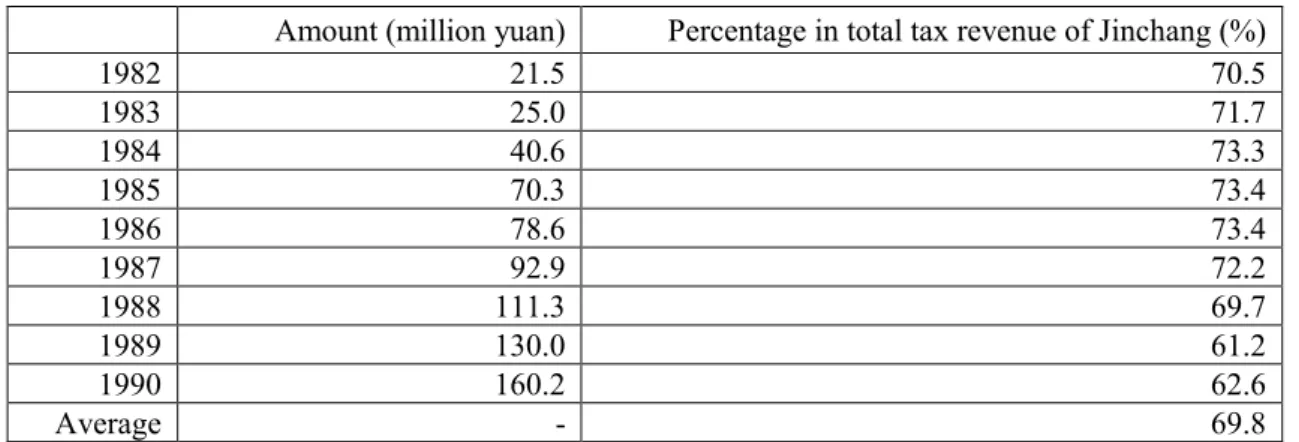
Table 1 Tax Payment by JNMC, 1982-1990
Amount (million yuan) Percentage in total tax revenue of Jinchang (%)
1982 21.5 70.5
1983 25.0 71.7
1984 40.6 73.3
1985 70.3 73.4
1986 78.6 73.4
1987 92.9 72.2
1988 111.3 69.7
1989 130.0 61.2
1990 160.2 62.6
Average - 69.8
Source: The Jinchang Chronicles (Jinchang shizhi).
Industrial Development
An ore deposit was first discovered in the Yongchang (永昌) County in 1958. The mining of nickel started in 1959. In 1961, the Yongchang Nickel Mine was renamed as the Jinchuan Non-ferrous Metals Corporation (currently, Jinchuan (
金川
) Group Ltd., he- reafter, JNMC). In 1962, the Jinchuan Coun- ty was established. In 1981, the Jinchang County became a city.The importance of mining and related metallurgical/chemical industry for Jinchang
is reflected in the expansion of JNMC. Table 1 presents the tax payment by the company during the period of 1982-1990. On the value base, the tax payment by JNMC had in- creased monotonically from 21.5 million yuan in 1982 to 160.0 million yuan in 1990.
In the meantime, on the percentage base, the tax payment by JNMC had accounted for 69.8 percent of the total tax revenue of Jin- chang on average over the period of 1982-1990.
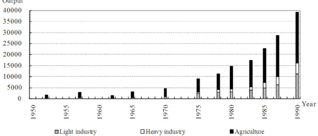
Figure 3 presents the changes in indus-
ICCS Journal of Modern Chinese Studies Vol.2 (1) 2010
trial structure of Jinchang during the period 1957-1991. Industrial sector had attained re- markable growth since the late 1950s. Using 1980 constant price, in 1957, the gross output value of industry was 956,000 yuan, less than one tenth of the gross output value of agri- culture. Soon after the nickel mining started
in 1959, the industrial output outperformed the agricultural output. The development of the mining-related heavy industry was espe- cially remarkable. During the period 1981-1991, the heavy industry had accounted for 95 percent of the total industrial output on average.
0 20000 40000 60000 80000 100000 120000 140000
1955 1960 1965 1970 1975 1980 1985 1990
Year Output
Agriculture Industry
Source: The Jinchang Chronicles (Jinchang shizhi).
Figure 3 Jinchang: Changes in Industrial Structure, 1957-1991 (Unit: 10,000 yuan, 1980 constant price)
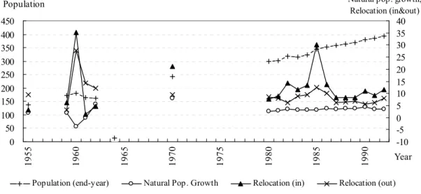
In-migration of Population
One peculiar feature in the process of building an industrial city is the mass reloca- tion of population into Jinchang. Figure 4 depicts the population increase and the relo- cation of population in Jinchang since 1955.
The total population of Jinchang had in- creased by three times from 138,500 in 1955 to 392,379 in 1992. In addition, except for the three years of 1960-1962, the number of the in-relocation of population had always exceeded the number of the out-relocation of population7. In the years for which the statis-
tics are available, the cumulative number of relocation into Jinchang amounted to 228,389. It accounted for four times of the natural population growth in the city.
The in-migration of population can be classified into two types. First, the popula- tion was relocated into Jinchang for the land reclamation. Gansu Bayi Farm (甘肃八一农
场
) was established in 1958 by 800 veterans from Lanzhou and Xi’an. According to the results of the 4th census conducted in 1990, the number of people associated with the Bayi Farm increased to 9,407. Secondly, aICCS Journal of Modern Chinese Studies Vol.2 (1) 2010
large number of the population had been re- located to Jinchang to work in the mining and related metallurgical/chemical industry.
This accounted for the vast majority of pop- ulation relocated to Jinchang. Table 2 pre- sents the list of counties/towns in Jinchang
by their sizes. Among three heavily popu- lated counties/towns of Jinchang, two (Jinchuan district and Hexibao (
河西堡))
have expanded due to the in-migration of population.0 50 100 150 200 250 300 350 400 450
1955 1960 1965 1970 1975 1980 1985 1990
Year Population
-10 -5 0 5 10 15 20 25 30 35 40 Natural pop. growth,
Relocation (in&out)
Population (end-year) Natural Pop . Growth Relocation (in) Relocation (out)
Source: The Jinchang Chronicles (Jinchang shizhi).
Figure 4 Jinchang: Population Increase and Relocation of Population, 1955-1992 (Unit:
1,000 persons)
In 1958, a large number of workers, technicians and managers were relocated from Heilongjiang, Liaoning and Baiyin (
白 银
), Gansu into the Jinchuan mining area.They, themselves and their families consti- tute the main part of population of the Jin- chuan district, i.e., the urban center of Jin- chang. The population of the Jinchuan dis- trict was 14,317 by the end of 1961. It in- creased to 111,417 in 1982. In addition, after the establishment of Jinchang city in 1981, the government permitted the families of mine workers to change their status from a
rural register to urban register (Hukou,
户口,
Nongzhuanfei,农转非
). The implementation of the policy led to the increase in the urban population of Jinchang. In 1990, at the time of 4th census, the population in the Jinchuan district attained 159,579.In the meantime, after the enterprises in- cluding the Hexibao Iron Plant and Yong- chang Power Plant were established in 1958, many workers, technicians, managers and their families were gradually relocated into the Hexibao town. In 1964, the population was 10,348 in Hexibao town, while the
ICCS Journal of Modern Chinese Studies Vol.2 (1) 2010
number amounted to 36,717 in 19828.
Water Diversion Project
Industrial development and the in-migration of population have substantially increased the water consumption in Jinchang;
however, the city was established in a place where water resources could not afford such
extensive scale of economic activities and a large population. On September 17, 2008, when we conducted a fieldwork in the Xi- axiaogou (
下小沟
) village9 located in Shua- ngwan town, Jinchuan district, the villagers told us that the water table had dropped from 2-3 m in the early 1970s to current 50-70m.Table 2 Size of Counties/Towns in Jinchang, 2003 Size (10,000 persons) No. Name of counties (towns)
Small cities (5-20) 1 Jinchuan district (金川区)
Large towns (2-5) 2 Chengguan town (城关镇), Hexibao town (河西堡镇) Small towns (<1) 6
Xinchengzi town (新城子镇), Dongzhai town (东寨镇), Shuiyuan town (水源镇), Zhuwang town (朱王堡镇), Ningyuan town (宁远堡镇), Shuangwan town (双湾镇) Note: Currently, in China, there are five practical (de facto) levels of local government: the provincial
level (省级行政区), prefecture level (地级行政区), county level (县级行政区), township level (乡 级行政区), and village level (村级自治组织).
Source: Chen, Zhen and Mao (2006:17).
To ameliorate the water shortage, the water diversion project was proposed by the Jinchang government. However, up to now, the project seems to fail to improve the situa- tion of Jinchang. In 1983, two years after the establishment of Jinchang, the city govern- ment submitted a report to the Gansu provin- cial government about water diversion. In 1984, the project “Yinliuruxi (
引硫入西
)”was proposed by the Gansu provincial gov- ernment to the national government. The project aimed to transfer water from Liu- huanggou(
硫 磺 沟
)10 to Xidahe (西大河
) river in Jinchang. In 1986, the project was renamed as “Yinliujijin (引硫济金
)”, i.e., transferring water from Liuhuanggou to sup-port Jinchang. The construction of the pro- ject started in 1995 and completed in 2003.
However, the completion of the project ap- pears not to have ameliorated the situation in Jinchang. According to the Gansu Daily, by July 1, 2008, the two main reservoirs in Jin- chang, i.e., Huangcheng (
皇 城
) and Jin- chuanxia (金川峡
) could meet the water de- mand of the city only for seven days. On the 3rd of July, the Jinchang government re- leased a water-saving announcement to im- pose restrictions on both the productive and domestic water uses. In addition, the water supply to both the non-productive and non-domestic uses stopped temporarily dur- ing the period July 3rd-25th11.ICCS Journal of Modern Chinese Studies Vol.2 (1) 2010
3.3 Zhangye: Evidence from an a City Rely- ing on Agriculture for its Economic Base After 1949, Zhangye has been developed as an agricultural production base of China.
Consequently, large-scale land reclamation was conducted and the associated increase of water utilization resulted in the water short- age in the middle reaches of the Heihe River basin and also the environment degradation in the lower reaches12.
Agricultural Development
Zhangye has a long history of agricul- tural development which can be at least traced back to Han Dynasty. In 1949, the Zhangye district was established. In 1985, Zhangye city (county-level) was established.
In 2002, the jurisdictional area of Zhangye was re-defined, and the administrative level of the city was raised to municipal-level13.
Table 3 Zhangye: Construction of Agricultural Production Base
1963 Recognized as one of 15 provincial food crop production base counties (quansheng liangshi shengchan jidi xian, 全省粮食生产基地县)
1971 Recognized as one of 25 national food crop production bases (quanguo shangpinli- ang jianshe jidi, 全国商品粮建设基地)
1983 Recognized as one of Dingxi-Hexi agricultural construction counties (cities) (“Hexi- Dingxi” liangxi nongye jianshe xian(shi), “两西”(定西,河西)农业建设县(市)) 1986 Recognized as one of provincial food crop base construction counties (cities) (qua-
nsheng shangpinliang jidi jianshe xian(shi), 甘肃省商品粮基地建设县(市)) 1987 Recognized as one of 25 national food crop production bases (quanguo wuda
shangpin shucai shengchan jidi, 全国五大商品蔬菜生产基地)
Currently
Recognized as one of national key food crop production bases (quanguo zhongdian shangpin liang shengchan jidi, 全国重点商品粮生产基地), and one of 5 national vegetable production bases (“western vegetables to the east (xicaidongyun jidi)”, 全 国“西菜东运”基地)
Sources: The Zhangye Chronicles (Zhangye shizhi), official website of Zhangye government (URL:
http://www.zhangye.gov.cn/Index.html (as of Jan. 12, 2009)).
The agricultural development in Zhangye has gained much attention from both the lo- cal government and central government. As Table 3 shows, up to date, Zhangye has been recognized as either provincial-level or na- tional-level agricultural production base for at least 6 times. Currently, Zhangye is recog- nized as one of the national key bases of food crop production, and also one of the five na- tional bases of vegetable production.
Figure 5 presents the changes in indus- trial structure of Zhangye during the period 1952-1990. It is obvious that Zhangye's economy has been agriculture-based. Al- though the development of industry, espe- cially, light industry among others, has been remarkable since 1950s, the gross agricul- tural output has continuously outperformed the gross industrial output. Using 1980 con- stant price, the gross industrial output in-
ICCS Journal of Modern Chinese Studies Vol.2 (1) 2010
creased from 1.7 million yuan in 1952 to 162.9 million yuan in 1990. The gross agri- cultural output increased from 15.6 million yuan in 1952 to 228.6 million yuan in 1990.
In 1990, the gross agricultural output was two times the gross output of light industry, and 4.5 times the gross output of heavy in- dustry.
Source: The Zhangye Chronicles (Zhangye shizhi).
Figure 5 Zhangye: Changes in Industrial Structure, 1952-1990 (Unit: 10,000 yuan, 1980 constant price)
Land Reclamation
Given the importance of Zhangye as an agricultural production base, large-scale land reclamation had been conducted after 1949.
In 1957, the Gansu provincial government conducted an estimation of reclaimable land area along the Hexi Corridor. Zhangye ac- counted for 39 percent by 169,333 ha14; however, from 1949 to 2008, the total culti- vated area in Zhangye has increased from around 60,000 ha to 260,000 ha15. This im- plies that the land reclamation was also con- ducted in the area unsuitable for the cultiva- tion. Figure 6 shows that the sown area of two primary crops in Zhangye, i.e., wheat and maize, had experienced a substantial in- crease and finally stabilized at around
100,000 ha in the 1990s. In the absolute val- ues, the total sown area of wheat and maize had increased from 39,587 ha in 1950 to 104,620 ha in 1997.
The land reclamation in Zhangye has mainly taken the form of farm-building. In 2005, the total land area of state-owned farms was 41,835 ha, of which cultivated land accounted for 4,847 ha. The total culti- vated land area of three big farms in Zhangye, i.e., Zhangye Farm (
张掖农场
), Shandan Farm (山丹农场
) and Linze Farm (临泽农
场), accounted for 4,640 ha
16. Put roughly, the land reclamation in the form of farm-building can be classified into the fol- lowing two types.ICCS Journal of Modern Chinese Studies Vol.2 (1) 2010
1) Production-Construction Corps-led land reclamation.
In Gansu, the land reclamation led by the Production-Construction Corps was conducted during the period 1963-1974. In total, the Corps reclaimed land of 24,767 ha during the period17. To examine the Zhangye Farm of Ganzhou district as an example, it was established in 1955 and taken over by the PLA (Peo- ple’s Liberation Army) Agriculture De- velopment No. 11 Division No. 4 Regi- ment in 1965, thereafter, in 1975, it was devolved to the local government, and renamed from Lanzhou Military Region Production-Construction Corps No. 2 Division No. 2 Regiment to State-owned Zhangye Farm. In 1990, the total land area of the Zhangye Farm was 6,800 ha, and the cultivated land area amounted to 1,533 ha18.
2) Local government-led land reclamation.
The local government-led land reclamation started soon after the completion of land reform in 1952.
Since 1954, various Danwei (working units,
单位) had established farms in
Zhangye. Although these farms had undergone several changes including the merger with other farms, take-over and devolvement by the army, in 1990, the number of Danwei farms in Zhangye exceeded 70. The total land area ofDanwei farms amounted to 3,000 ha, and the cultivated land was 1,667 ha19.
After 1978, the land reclamation in the form of farm-building had stopped;
however, the government has continuously encouraged the land reclamation by granting economic incentives to farmers. In the Ganzhou district, during the period 1984-1990, 12 million yuan had been invested to reclaim land of 5,000 ha.. The government accounted for about half of the expenditures. Exactly, the fiscal appropriation accounted for 5.9 million, the collective investment accounted for 2.4 million, and the investment by individual farmers accounted for 3.7 million20.
In the Shadow of Heihe River Project The expansion of cultivated land in the middle reaches of the Heihe River basin in- cluding Zhangye after 1949 entailed the sub- stantial increase in the consumption of water.
As a result, the discharge released to the lower reaches decreased. Serious degradation of the environment occurred in the lower reaches.
In order to prevent the environment deg- radation in the lower reaches, Heihe project was initiated in 2000 by the Chinese gov- ernment to release river water to the lower reaches. Since 2003, Zhangye has been re- quested to release 950 million m3 per year to the lower reaches by administrative order. In
ICCS Journal of Modern Chinese Studies Vol.2 (1) 2010
2002, one of the terminal lakes in the lower reaches (eastern Juyan,
居延) revived; how-
ever, due to the release of water to the lower reaches, the volume of agricultural water in- take declined. Therefore, Zhangye has be- come more dependent on the groundwater forirrigation due to the lesser accessibility to river water. The groundwater level had de- clined rapidly since the start of the Heihe project. Moreover, the water for irrigation of cultivated land is not sufficient.
0 20000 40000 60000 80000 100000 120000
1950 1955 1960 1965 1970 1975 1980 1985 1990 1995
Sown area
Year Sown area: wheat+maize
Source: The Zhangye Crop Chronicles (Zhangye diqu liangshizhi), p.38.
Figure 6 Zhangye: Changes in Sown Land Area, 1950-1997 (Unit: ha)
On September 19, 2008, when the au- thors conducted fieldwork in the Xiaotun (
小 屯
) village located in Yanuan (鸭暖
) town, Linze county, some villagers told us that the water table of wells had dropped sharply due to the excessive well pumping. In Xiaotun, the average depth of wells is 20-30 m, while in the neighboring Pinchuan (平川
) town, the depth of wells usually exceeds 100 m. On the same day, the authors conducted fieldwork in the Heihe Farm21. The water has not been provided to the farm since 2006. The fruit trees are dying from lack of water. People belonging to the farm have lost their ways ofliving. Young people moved out of the vil- lage to get a job as migrant workers, while the old people stay at home hoping for the support from the government.
4. Concluding Remarks
Through examining the history of Jin- chang and Zhangye after 1949, this study revealed the relationship between the past economic development strategies and current water stress in the Gansu Province, North- western China. We found that the large-scale development in the environmentally fragile areas is the fundamental reason of the water stress and related environmental issues in the
ICCS Journal of Modern Chinese Studies Vol.2 (1) 2010
region. The study provided the evidences from Jinchang and Zhangye which had adopted different economic development strategies. One city is an industrial city which relies on the mining and related heavy industry for its economic base, while the other one relies on the agriculture for its economic base.
First, the pursuit of economic benefits has propelled an unsustainable exploitation of environment. In both the cities, the current water shortage is due to the large-scale de- velopment conducted since 1949. In Jinchang, a development strategy lacking long-term concerns led to the construction of an indus- trial city in a place where water resources may not afford such a huge population and extensive economic activities. In Zhangye, a development strategy lacking river ba- sin-wide vision led to the large-scale agri- cultural development in the middle reaches of the Heihe River basin. As a result, the
water environment in the lower reaches had deteriorated.
Secondly, humanity’s suffering is inter- twined with nature’s suffering in the eco- nomic development process led by a proac- tive developmental state. Here, the human- ity’s suffering is reflected in the relocation of population. The suffering of nature is re- flected in the degradation of water environ- ment. In both cities, we witnessed that a large number of people had been relocated to ful- fill the development strategies of the gov- ernment. In Jinchang, a lot of people were relocated into the city to build a brand-new industrial city in the Gobi desert. In Zhangye, when the priority of development strategy changed from agricultural development to environmental protection, the non-conforming places for the new strategy such as the Heihe Farm are abandoned, and the local people’s interests were ignored in the decision-making process22.
1 Department of International Studies and Re- gional Development, the University of Niigata Prefecture.
E-mail: [email protected]
2 Department of Urban Engineering, the Univer- sity of Tokyo.
E-mail: [email protected]
3 Potential evaporation or potential evapotranspi- ration (PET) is the amount of evaporation that would occur if a sufficient water source were available.
4 Define annual precipitation as P and potential evaporation as PET. Arid region refers to the area wherein 0.05<P/PET<0.20, while semi-arid region the area wherein 0.20<P/PET<0.50. P/PET is called as aridity index.
5 Gansu Yearbook, 2007.
6 Shalizi (2006: 5).
7 One year lag of the 3 Years of Natural Disasters during 1959-1961.
8 All data related to the population relocation are from the Jinchang Chronicles.
9 The village is a well-irrigation district.
10 Liuhuanggou is the tributary of Datonghe (大 通河) river which is located in Menyuan county (门源县) of Haibei (海北州), Qinghai province.
11 Gansu Daily,September 2nd, 2008. Jinchang Government Announcement to Combat Drought and Save Water. July 3rd, 2008.
URL:http://gsrb.gansudaily.com.cn/system/2008/0 9/02/010824971.shtml (as of Jan. 12, 2009) URL:http://www.jcxzzx.com/Article/gongzuodon gtai/benshi/200807/887.html (as of Jan. 12, 2009)
ICCS Journal of Modern Chinese Studies Vol.2 (1) 2010
12 For instance, the two terminal lakes, i.e., west- ern and eastern Juyan lakes dried up in 1961 and 1991 respectively.
13 The jurisdictional area of former Zhangye city was renamed as Ganzhou district (甘州区). Since then, Zhangye city includes one city district, 4 counties and one autonomous county.
14 The Gansu Chronicles, Vol. 19:11. The juris- dictional area of Zhangye here includes part of Jiuquan (酒泉) city as well. The original docu- ment is called “The Collection of Documents about Wasteland in Hexi Region, Gansu Prov- ince”.
15 Field interview conducted in the Bureau of Water Resources of Zhangye (Zhangye shuiwuju, 张掖水务局), September 18th, 2008.
16 Zhangye Statistical Yearbook, 2004-2005.
17 In 1963, PLA (People’s Liberation Army) Ag- ricultural Development No. 11 Division was es- tablished. However, due to the start of Cultural Revolution, land reclamation led by the PLA Ag- ricultural Development No. 11 Division stopped in the late 1966. In 1969, the land reclamation resumed accompanied by the establishment of Lanzhou Military Region Production-Construction Corps. The farms run by the army were devolved to the local government in 1975. The Gansu Chronicles, Vol. 19.
18 The Zhangye Chronicles.
19 The Zhangye Chronicles.
20 Gansu Yearbook, 1991.
21 The Heihe Farm is located 2.3 km away from Yingluoxia (莺落峡) where there is dam to con- trol the flow of water from the upper reaches. The farm consists of 300 households and 113 ha of cultivated area.
22 The recent development trends of two cities are as follows. In 2008, Jinchang was recognized as one of 7 national high-tech industrial bases. Sev- eral projects including Jinchang airport, petroleum city, chemical industrial base are under construc- tion. In 2008, Zhangye government initiated 3 agricultural projects, i.e.: Jinchangye (金张掖) seed maize production base, Western China potato processing and planting base, modern agriculture project (greenhouse vegetables and grapes).
References
Chen, Huailu, Yanlin Zhen, and Liwei Mao. A Research on Jinchang’s Urban System Struc- ture. In Journal of Arid Land Resources and Environment. Vol. 20(2): 17-22. 2006. (In
Chinese)
Chen, Jing. Water Use in the Middle Reach of Heihe River Basin. In Chugoku henkyo chiiki no gojunen (edited by Nakawo, Hohbaatar and Konagaya). Toho Shoten. Tokyo. 2007.
(In Japanese)
Gansu Yearbook (former Gansu Statiscal Year- book). China Statistics Press. Beijing. Vari- ous years.
Shalizi, Zmarak. Addressing China’s Growing Water Shortages and Associated Social and Environmental Consequences. World Bank Policy Research Working Papers, WPS3895.
2006.
The Gansu Chronicles, Vol. 19 (Gansu shengzhi).
Gansu People Press. Lanzhou: Gansu. 1993.
The Jinchang Chronicles (Jinchang shizhi). China City Press. Beijing. 1995.
The Zhangye Chronicles (Zhangye shizhi). Gansu People Press. Lanzhou: Gansu. 1995.
The Zhangye Crop Chronicles (Zhangye diqu liangshizhi). Gansu People Press. Lanzhou:
Gansu. 1999.
UNEP. World Atlas of Desertification. Edited by Nicholas Middleton and David Thomas.
Hodder Arnold. London. 1992.
UNEP. World Atlas of Desertification. Edited by Middleton N., Thomas D.. 2nd edition. Ed- ward Arnold. London. 1997.
Zhangye Statiscal Yearbook, 2004-2005. Gansu Culture Press. Lanzhou: Gansu. 2007