GEOGRAPHICAL REPORTS
OF TOKYO METROPOLITAN UNIVERSITY 50 (2015) 117-126
RESEARCH PERSPECTIVES AND METHODS ON THE CHANGES OF AGRICULTURAL LAND USE
IN METROPOLITAN AREAS
Toshio KIKUCHI* and Eranga RANAWEERAGE*
Abstract This paper reviews the perspectives of research on the changes of agricultural land use and reveals two main methods used in such research; static analysis and dynamic analysis of agricultural land use. In static analysis, the main focus is given to the spatial aspects of land use change through the development of several models such as Thünen model, Sinclair model and Bryant model. The dynamic analysis considers both spatial and temporal aspects of agricultural land use and implements the concepts of driving forces and sequence system of agricultural land use. The paper emphasizes on the importance of considering farmers’ perspectives and behavioral scientific discussions in analyzing the changes of agricultural land use.
Key words: agricultural land use, static analysis, dynamic analysis, driving force
1. Perspectives of Geographical Research on Agricultural Land Use
Land use is a projection of people’s life style and activities onto the land surface, which reflects deeply on various environmental conditions such as nature, economy, history and culture. As a result, research on land use has been the most traditional and fundamental subject to study in geography. More specifically, agricultural land use has been a main topic of interest among geographers as it directly represent the relationship between people and their environment. The research about agricultural land use can be divided into two categories; one is a static analysis of actual agricultural land use to identify its spatial distribution and patterns, while the other is a dynamic analysis of temporal variations of agricultural land use from the past to present.
2. Static Analysis of Agricultural Land Use
The research about spatial changes in agricultural land use were originally focused on the arrangement and the order of each land use. These research added to the concept of city centered agricultural land use as discussed in Thünen model. Thünen model, which is based on the theory of economic rent, explains that the intensity of agricultural land use varies according to the distance from the city and the transport cost of goods. This traditional point of view was widely
* Department of Tourism Science, Tokyo Metropolitan University
- 117 -
accepted by the researchers during the period of 1960 to 1970, and empirical evidences were accumulated (Golledge 1960; Muth 1961; Goldsmith and Cropp 1964; Griffin 1973). For example, the demand for food by city dwellers influenced the development of land uses for dairying and intensive farming in the suburbs. This is due to the deployment of the land conditions and the locational conditions into profitability by transporting the agricultural products from a close distance (Griffen and Chathan 1958). However, regardless of the profitable conditions of the suburban farm lands, there has been a decline in agricultural land use (Coleman 1978; Platt 1981).
Further, in Thünen model, the economic rent of suburban agricultural land use is decided without concerning the economic rent of urban land use. The economic rent of suburban agriculture is strongly influenced by the process of urbanization.
Therefore, a new model called Sinclair model was developed to better explain the patterns of agricultural land use in the suburbs. Sinclair (1967) pointed out that rather than the distance from the market, the rapid developments of urban areas act as a key factor influencing the investments on agricultural products and the agricultural land use. The land prices of suburban farmlands increased as a result of the land speculations. Land speculations increased the prices of suburban farmlands, which in result caused a fraction of farmlands and also large distribution of idle lands.
At the same time, a trend of extensive farming such as part-time farming and weekend gardening was increasing in the suburbs. Thus, the land prices increased with the proximity to the city while the intensity of agricultural land use increased with the distance from the city (Mattingly 1972;
Bryant 1981; Berry 1979). Further, Bryant (1973) revealed that the importance of suburban agriculture is diversifying and the level of influence from urbanization depends on the type of agricultural land use and its managerial framework. Bryant (1973) thus found out the parabolic curve which shows that the intensity of agricultural land use initially rises with the distance to the city but drops in remote regions. This was called Bryant model and it was a combination of Thünen model and Sinclair model (Bryant et al. 1982). Furthermore, Boal (1970) explained that the urban land uses are controlled by the green belts and suggested a model which shows the value of agricultural land use significantly increasing outside the green belts (Fig. 1).
Fig.1 A model of agricultural land use change in and around the metropolitan areas (Bryant et.al., 1982)
- 118 -
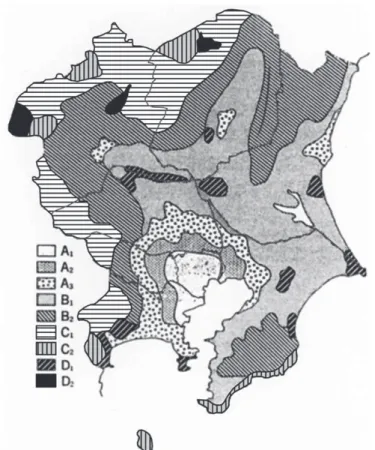
Aoga (1935), Yamamoto et al. (1977), and Yamamoto and Saito (1986) also tried to understand the distributional pattern of agricultural land use by creating some models. According to Aoga (1935), with the distance from the city, agricultural land use in the western suburbs of Tokyo changes sequentially from horticulture such as root crops, green vegetables and fruits cultivations, to cattle breeding, livestock farming, forestry for nursery and fuel. Accordingly, the scale of management becomes larger and the investment on labor, capital and fertilizers become lower. This type of agricultural land use has a tendency to be concentric and thus quite similar to Thünen model. Yamamoto et al. (1977) also confirmed that the agricultural land use in western suburbs of Tokyo is similar to the concept of Thünen model. However, the pattern has a tendency to change when observed with the railroad as an axis, indicating that the distributional pattern of the agricultural land use is not only effected by the geographical location from a city, but also by various social and economic factors such as transportation and land value. Further, Yamamoto and Saito (1986) discussed about the agricultural land use in the Kanto district in a similar pattern to Thünen model, but also focused on agricultural land use where intensive farming in outer fringes and truck farming in peripheral highlands were conducted to target the metropolitan markets (Fig.
2). These regions were called “farming islands” in the spatial structure, and were distributed throughout the Kanto district dispersively. Farming islands were based on the improvements of transportation systems, intensity of off-farm jobs, year-round requirements of agricultural products and their diversity, and also the specialty in farm management. Accordingly, Yamamoto and Saito (1986) explained how the various interrelated conditions of a region impacted on the transformations of Thünen model, Sinclair model or Bryant model.
The above mentioned analyses on spatial configuration of agricultural land use have several weaknesses. One weak point is that agricultural land use is explained based on the assumption that all the farmers and rural societies within a region correspond to urbanization and its effects in the same way. However, the reaction of farmers to the urbanization pressures varies based on various social and economic factors as well as the intensity of the urbanization (Bryant 1981). Even though, the Bryant model attempted a discussion more like on the basis of behavioral science to identify the spatial changes and distributional pattern of agricultural land use in the suburbs, it lacked discussions on the influence from decision-makings of individual farmers. Another weakness is that the factor analysis of the configuration of agricultural land use was mainly focused on the direct influences of urbanization such as the increase in demand, job opportunities in the urban industries or the expansion of agricultural product market in the urban areas (Sinclair 1967; Griffin 1973; Mather 1986; Munton 1974; Blair 1980; Rhind and Hudson 1980; Bowler 1984). However, these factors could not explain the spatial changes of agricultural land use completely, and many geographic research pointed out the importance of considering the temporal changes and a dynamic system in order to reveal the changes of agricultural land use comprehensively (Munton 1974; Pacione 1986; Bryant and Johnston 1992).
Therefore, research began to consider not only the impact of urbanization but also interrelations of various other spatial and temporal factors of a region including natural environment (land and climatic conditions), social/economic environment (technological advancement, infrastructure, land ownership, modernization and rationalization, policies), and historical/ cultural environment (standard of life, life style, living culture, development history) as key parameters of agricultural land use change (Moran 1979; Kikuchi and Moran 1990; Kikuchi 1994; Kikuchi and Tsutsumi 1998). Consequently, the research based on the analysis of spatial
- 119 -
changes as described in Thünen and Sinclair models, began to include temporal changes as an important element of agricultural land use research.
Fig. 2 Regionalization of the Kanto district in terms of agricultural land use patterns(Yamamoto and Saito, 1986).
Note A1: Real estate management, A2: Intensive vegetable cultivation, A3: Permanent off-farm working (white-collar worker), B1: Permanent off-farm working (blue-collar worker), B2: industrial crops cultivation, C1: Part-time off-farm working, C2: Self-employed working (B&B farms), D1: Intensive farming in the outer fringe, D2: truck farming in highlands
3. Dynamic Approach of Agricultural Land Use
The research focusing on temporal changes of agricultural land use faces a challenge on how to restore past land uses at the preliminary stage of research. Kikuchi et al. (1997), restored the past data by coloring the Japan’s former overseas territories map of 1930s (a topographic map 1:10000 created in overseas by the land survey department of army) for the analysis of agricultural land use changes in Beijing metropolitan area. The colored map was categorized into 20 km mesh, and the combinations of land use were calculated by using the combination analysis method. This type of mesh data helped to compare the temporal and spatial aspects of land use as well as to
- 120 -
identify the interrelations between the land use and other geographical information (such as population, economy, climate, topography). Mesh data can also be created by using existing land use maps and satellite images. Kikuchi et al. (1997) restored land use of Beijing Metropolitan area in 1985 and 1995 from the existing land use maps and satellite images. In this way, it was possible to match the mesh data of 1935, 1985 and 1995 and to understand the temporal and spatial changes of agricultural land use in Beijing Metropolitan area (Fig. 3).
The research about the agricultural land use change in Beijing Metropolitan area was not only focused on temporal and spatial changes, but also analyzing the causes of land use and land cover changes. This was due to the global importance given to the research about land use or land cover changes as highly significant in solving food issues, and promoting related academic research by international organizations from 1990. In the analysis of land use or land cover change, discovering the driving force was a common challenge for each country or a research field.
Driving forces can be divided into internal and external factors affecting the land use change, or direct factors such as population, economic activities, policies, resource usage, and indirect factors such as social system, technical advancement, land values, and lifestyle (Meyer and Turner 1994).
The main driving forces of the agricultural land use change in Beijing Metropolitan area were policy, population, urbanization, agricultural technology, resource usage. However, these driving forces were not operating in the same manner for every period studied. Prior to the socialist economy, resource usage and agricultural technology were the main driving forces (Li et al. 2013).
In socialist economy, policies and economic systems were also included and in socialist market economy, population and urbanization were further recognized as the driving forces. In these combinations, a change of one driving force influenced the overall forces and subsequently overall forces changed to keep the balance of the combination, which enabled stable and smooth change in agricultural land use.
Fig. 3 Combination types of land use in the southern part of Beijing metropolitan area, 1995 (Kikuchi et.
al., 1997)
- 121 -
With the implementation of the driving force concept, research on changes of agricultural land use also started focusing on policy and planning. In previous geographical research, understanding the actual situation of spatial and temporal changes of agricultural land use was an important topic of study. However, understanding the actual situation was a priori in interdisciplinary research, yet prediction of future land use change was a task. Prediction of future change was done by considering the driving forces as variables. These variables were first analyzed to identify the change of land use, and then future change was predicted by predicting the change of the variables.
On the other hand, ecological approaches were incorporated into the frameworks of research about temporal change in agricultural land use. Originally, the land use is the space where people mutually interact with natural environment and socio-economic environment, and land use change is the process in which human activities attempt to adapt to such environmental conditions.
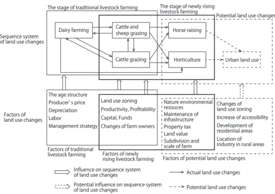
Concretely, Kikuchi and Moran (1990) and Kikuchi (1994) analyzed the changes of agricultural land use in Auckland, New Zealand as a sequence system on agricultural land use. In these research, changes of agricultural land use were categorized into few stages such as traditional livestock farming stage, newly rising livestock farming stage, horticulture stage and urban land use stage, and the change was explained as a sequence from the traditional livestock farming stage to the urban land use stage through the newly rising livestock farming and horticulture stage.
However, a sequence system to provide feedback was created in the stage of traditional livestock farming, which considered changes in dairy farming management, cattle/sheep mixed-grazing management as well as cattle mono-grazing management in adapting to the reverse changes in labor force, market price of products and transition of generation. This sequence system was able to mutually complement land, facilities, equipment and livestock, which created changes to agricultural land use that can flexibly adapt to the changes of urbanization or socio-economic environment. On the other hand, in the stages of horticulture and urban land use, another system not to provide feedback about the changes of agricultural land use was formulated, which became the reason for the one sided land use change caused by subdivision of farmlands, advancement of facilities and equipment and intensification of farmlands (Fig. 4).
These two sequence systems affected the possibility and impossibility of the agricultural land use change. The first system was also viewed as the mechanism for sustainability of agricultural land use change. The characteristics of sustainability include not only the consistency of land use change, but also the consistency of frame works and structure of agricultural and urban land uses.
In other words, change of a specific agricultural land use to another form of agricultural land use controls transformation of agricultural land use to an urban land use, which in result sustain the frameworks of agricultural and urban land uses. This has been regarded as the sustainability of agricultural land use change (Tabayashi and Kikuchi 2000). However, regional conditions and viable basis related to the sustainability of land use change have not been investigated sufficiently, and concrete analysis of such aspects have become a task of geographical and related scientific studies (Androkovich 2013).
- 122 -
Fig. 4 The sequence system of land use change in Auckland, New Zealand (Kikuchi 1994)
4. Potentials of Agricultural Land Use research and New Perspectives
Until the first half of 1980s, majority of the research about agricultural land use was investigations on Thünen model, Sinclair model or Byrant model, with the main emphasis on various causes of diverse land use patterns and their interrelations. After the latter half of 1980s, temporal and spatial patterns of the agricultural land use became the main focus. Based on the analysis of temporal and spatial patterns, the concept of driving forces, their interrelations and frameworks of sequence systems were created. However, one neglected aspect of these research was the differences among correspondences and decision-making of individual farmers towards the driving forces, and behavioral scientific discussions such as impact of different decisions on agricultural land use change (Zhu 2013; Van Doorn and Bakker 2007). The diversity of farmers’
correspondences and decision-makings depends on various conditions including their ability to identify the influence of the driving forces and subsequent changes in the surrounding environment, personal interests, and usable resources for individual farmers (Zhou et al. 2005).
Therefore, it became essential to study how the individual farmers or regional actors (stake holders) and the decision-making of farming societies are related to the changes in agricultural land use.
For example, Bryant (1981) when explaining the agricultural land use changes in Paris Metropolitan area, brought up a model on how farmers recognized and corresponded to the impact of urbanization. In Bryant’s observations, it was concluded that decisions by farmers diversified
- 123 -
based on the intensity of impacts from urbanization, which in return weakened the sustainability of agricultural land use. However, further empirical studies were required to generalize this conclusion as Bryant’s research included only a few case studies of famers. Further, Layton (1981) revealed that farms with different backgrounds and plans make decisions differently towards the changes in agricultural land use. Blair (1980) also pointed out that farmers’ reaction to agricultural opportunities and limitations influenced the sustainability of agricultural land use. In other words, correspondences of individual farmers or farming families to a particular phenomenon and background is an important factor associated with agricultural land use (Helming et al. 2008). For example, as Kikuchi and Takatori (1999) indicated that reactions of farmers to the trespass phenomenon (invasion of farm lands and robbery of farm goods) in the suburbs, strongly influenced the decisions on the continuation or suspension of agricultural land use.
Even though there was a repeated emphasis on the importance of individual famers’
correspondences to a particular phenomenon and background associated with the changes of agricultural land use based on empirical research, the mechanism of famers’ decision making on the changes of agricultural land use was not sufficiently explicated, which became one of the main tasks for research related to agricultural land use change. However, in 1990s, there have been several publications indicating the direction of future research. One is considering a particular agricultural land use as the basis of “actor space”, and another one is discovering the behavioral scientific mechanism of agricultural land use change. The point of view of actor space is about analyzing how a particular individual or agricultural land use adopted to the natural, socio economic and historical or cultural environment of a region while influencing another type of land use, and how the regional characteristics of agricultural land use were decided independently by changing from a point basis existence as an actor to a regional basis existence as an actor space.
For example, Kikuchi (2002) investigated on the hobby farms in Sydney Metropolitan area, and revealed that these hobby farms were a result of the productive aging policy and the suppression of urban land use as well as traditions and aspirations of pastoral lifestyle. The hobby farms functioned as an actor for alternation of generations and transition of ownership, and then developed into a principal land use by expanding its networks. On the other hand, to discover the behavioral scientific mechanism, Kikuchi (2002) discussed the mechanism of farmland diversion in areas designated for urbanization from the point of view of individual farmer’s decision-making.
This study evaluated each farmer specific period (period that require alternation of generations or branch family housing, period of law enforcement or land price increase) to each locational conditions of farm lands (topography, soil, distance from home, accessibility to main road) and found out that it was a step by step process of decision-making on whether to continue agricultural land use or divert the farmland to another use (Hassan 2010). Both cases revealed the changes of agricultural land use as a phenomenon, yet, the link between such changes and decision-making by individuals or regional actors have not been clarified concretely.
References
Aoga, S. 1935. Nohgyo Keizai Chirigaku (Economic Geography of Agriculture). Tokyo:
Soubunkaku.*
Androkopvichi, R.A. 2013. British Columbia’s agricultural land reserve: economic, legal and
- 124 -
political issues. Land Use Policy 30: 365-372.
Berry, D. 1979. Sensitivity of dairying to urbanization: a study of North-East Illinois. Prof.
Geogr., 31: 170-176.
Blair, A.M. 1980. Urban influences on farming in Essex. Geoforum 11: 371-384.
Boal, F.W. 1970. Urban growth and land value: government influence. Prof. Geogr. 22: 79-82.
Bowler, I.R. 1984. Agricultural geography. Progr. in Hum. Geogr. 8: 256-262.
Bryant, C.R. 1973. The anticipation of urban expansion. Geographia Polonica 28: 93-115.
Bryant, C.R. 1981. Agriculture in an urbanizing environment, a case study from the Paris region, 1968 to 75. Canadian Geographer 25: 27-45.
Bryant, C.R. and Johnston,R.R.1992. Agriculture in the City's Countryside. London: Belhaven Press.
Bryant, C.R., Russwurm, L.H. and McLellan, A.G. 1982. The City's Countryside, Land and its Management in the Rural-Urban Fringe. London: Longmans.
Coleman, A. 1978. Last bid for land-use sanity. Geogr. Maga. 50: 820-824.
Goldsmith, H.F. and Cropp, J.H. 1964. Metropolitan dominance and agriculture. Rural Sociology 29: 385-395.
Golledge, R.G. 1960. Sydney's metropolitan fringe: a case study in rural-urban relations.
Australian Geographer 7: 243-255.
Griffin, E. 1973. Testing von Thünen’s theory in Uruguay. Geogr. Rev. 54: 564-571.
Griffin, P.F. and Chatham, R. 1958. Urban impact on agriculture in Santa Clara County, California.
Ann. Assoc. Amer. Geogr. 48: 195-208.
Hassan, M. R. (2010): Land Use and Land Value in Urban Fringe Area of Khulna, Bangladesh.
VDM Verlag.
Helming, K., Perez-Soba, M. and Tabbush, P. (2008): Sustainability Impact Assessment of Land Use Changes. Berlin: Springer.
Kikuchi, T. 1994. Land use change and its characteristics in the Auckland City’s countryside, New Zealand: a case study of the Clevedon area, Manukau City. Journal of Geography (Chigaku Zasshi) 103: 377-397. **
Kikuchi, T. 2002. Agricultural land use changes and their sustainability in the urban shadow of the Sydney metropolitan region, Australia: a case study of Castlereagh area, Penrith City. Journal of Geography (Chigaku Zasshi) 111: 81-91. **
Kikuchi, T. and Moran, W. 1990. Land use change and its characteristics in the Auckland metropolitan region, New Zealand: a case study of East Tamaki area, Manukau City. Geographical Review of Japan 63A: 741-765. **
Kikuchi, T. and Takatori, Y. 1999. Sustainability of agricultural land use changes in urban fringe : a case study in Chofu City, Tokyo metropolis. Regional Studies 40: 1-16. **
Kikuchi, T. and Tsutsumi, J. 1998. Sustainability and changeability of agricultural land use in the peri-urban environment: a case syudy in a sericulture region in Maebashi City, Central Japan.
Quarterly Journal of Geography 50: 1-16.**
Kikuchi, T., Zhang, G.M. and Guo, H.C. 1997. Land use changes and their driving force in the Beijing metropolitan area, China. Geographical Reports of Tokyo Metropolitan University 32:
43-57.
Layton, R.L. 1981. Attitudes of hobby and commercial farmers in rural-urban fringe of London, Ontario. Cambria 8: 33-44.
- 125 -
Li, J., Deng, X. and Seto, K. C. 2013. The impact of urban expansion on agricultural land use intensity in China. Land Use Policy 35: 33-39.
Mattingly, P.F. 1972. Intensity of agricultural land-use near cities: a case study. Prof. Geogr. 24:
7-10.
Mather, A.S. 1986. Land Use. New York: Longman.
Meyer, W.B. and Turner,B.L.1994. Changes in Land Use and Land Cover: A Global Perspective.
Cambridge: Cambridge University Press.
Moran, W. 1979. Spatial patterns of agriculture on the urban periphery, the Auckland case. Tijdschr.
Econ. en Soc. Geogr. 70: 164-176.
Munton, P.J.C. 1974. Farming on the urban fringe. In Suburban Growth, Geographical Processes at the Edge of the Western city. Ed. Johonson, J.H. 201-223. London: John Wiley and Sons.
Muth, R.F. 1961. Economic change and rural-urban land use conversions. Econometrica 29: 1-23.
Platt, R. 1981. Farmland conversion: national lessons from Iowa. Prof. Geogr. 33: 113-122.
Pacione, M. ed. 1986. Progress in Agricultural Geography. London: Croom Helm.
Rhind, D. and Hudson,R.1980. Land use. Methuer, London.
Sinclair,R. 1967. Von Thűnen and urban sprawl. Ann. Assoc. Amer. Geogr., 57, 72-88.
Tabayashi, T. and Kikuchi, T. 2000. Zizokuteki Nohson Sisutemu no Chiikiteki Zyoken (Regional Conditions of Sustainable Rural System). Tokyo: Nohrin-Tokei-Kyoukai.*
Van Doorn, A. M. and Bakker, M.M. 2007. The destination arable land in a marginal agricultural landscape in south Portugal: exploration land use change determination. Landscape Ecology, 22, 1073-1087.
Yamamoto, S,, Kobayashi, K., Tabayashi, A. und Sakurai, A. 1977. Landnutzungsformen in den westlichen randgebieten von Tokio: analyse der gitternetz-method. Tsukuba Studies in Human Geography I: 155-171. ***
Yamamoto, S. and Saito, I. 1986. Regionalization and land use, spatial structure of agricultural land use in the Kanto district. In Nihonn Chishi Zeminaru 3, Kanto Chiho (New Seminar on Regional Geography of Japan 3, The Kanto District). ed. Fujioka, K. 188-200. Tokyo:
Taimeido.*
Zhou, W., Yan, Y., Zeng, Y. and Zhong, X. 2005. Land use change and its effect on environment based on farmers’ behaviors: a case study in agricultural area of Tibet, China. Wuhan University Journal of Natural Sciences 10: 767-773.
Zhu, H. 2013. Underlying motivation for land use change: a case study on the variation of agricultural factor productivity in Xinjiang, China. Journal of Geographical Sciences 23:
1041-1051.
(*: in Japanese, **: in Japanese with English abstract, ***: in Japanese with German abstract)
- 126 -