Environmental assessment of heavy metal
contamination and land rehabilitation
strategies in mineralized area
著者
ARIE PUJIWATI
学位授与機関
Tohoku University
学位授与番号
11301甲第18955号
Doctoral Dissertation Summary
Environmental assessment of heavy metal contamination and
land rehabilitation strategies in mineralized area
(鉱化地域における重金属汚染の環境影響評価および修
復戦略に関する研究)
Arie Pujiwati
B6GD1501
Graduate School of Environmental Studies
Tohoku University
Japan
July 2019
Chapter 1: Introduction
1.1. Background
Studies have widely acknowledged that the existences of the post-mining area give influences to the environment in partial or complete leverages. The great numbers of post-mining leverages are not only occurred as short-term influences, but also as long-term impacts. Numerous environmental impacts of post-mining area have been recognized. A significant issue of environmental impacts due to post-mining activities is soil contamination, the alteration of the aquatic environment, human health risk, and change of biodiversity (Jewitt et al. 2015; Kostarelos et al. 2015; Lortzie et al. 2015; Zeng et al. 2015).
As already been investigated by significant numbers of research, the legacies of mining activities require recovery strategies. The recovery of post-mining areas was established by performing physical, biological, and chemical processes of the degraded land (Kubit et al. 2015; Ridsdale and Noble 2016). Among abundant post-mining recovery studies, generally, mining recovery strategies are identified as remediation, reclamation, rehabilitation, restoration, and revitalization. Remediation performs decontamination or removing pollutants from the sites through physical, chemical, and biological treatment to reduce the risk of contaminated sites to human beings (Beames et al. 2014; Haigh 2007; Rodrigues et al. 2009). The restoration of the pre-existing ecosystem is performed by replicating the original flora, fauna, or cultural values (Aronson et al. 2006; Clewell and Aronson 2013). Moreover, reclamation aims to restore the natural values to the post-mining area (Mhlongo and Amponsah-Dacosta 2016). Furthermore, Lima et al. (2016) have summarized the definition of rehabilitation is as
“a managerial term, measures costs, and benefits of maintaining environmental quality and optimize
local land management capacity, including practices such as agriculture, forestry, urbanization, and so
forth”. The last term in post-mining recovery strategies is revitalization which was introduced by Kuter
(2016) as the combination of reclamation and land development. Kaźmierczak et al. (2017) proposed this strategy as the new terminology due to its wider scopes and flexibility.
Based on the previous explanations, various post-mining recovery strategies have their own specialties which could be implemented based on the availability of the recovery resources and stakeholder preferences. At top of that, mining stakeholders are able to decide which recovery strategies are feasible to their sites and will give sustainable impacts to the environment. A study by Lima et al. (2016) has summarized considerations of the feasible recovery strategies. Among all strategies, rehabilitation is the last option for the post-mining recovery and acts as the ultimate goal for post-mining recovery. It is able to give more benefits of site utilizations to human beings and support the sustainable mining concept in the post-mining period.
as described in Sustainable Development Goals (Sonesson et al. 2016). The decision of rehabilitation, whether the site is restored to nature or to human utilization, require sustainability management. If the site is to be restored to its original ecosystem, the concern would be the development of a self-sustaining ecosystem without considerable human interfere. Thus, environmental resilient is important to consider. However, if the land is designated to have more utilization for human beings, the sustainability of that after-use is significant. For instance, new utilization of the post-mining site will not aggravate the post-mining site. Thus, some criteria are important to consider in terms of environmental criteria, for examples geochemical processes, geological conditions, surrounding environmental impacts, and human impacts (Haigh 2007; Worrall et al. 2009). Therefore, the incorporation of environmental sciences is necessary for post-mining rehabilitation.
Numerous studies have already established the post-mining rehabilitation decision making. The criteria to establish rehabilitation strategies are ranged from general to specific models. Various dichotomy decision tools are also applied to build the rehabilitation strategies (Doley et al. 2012; Gastauer et al. 2018; Masoumi et al. 2014; Hossein Soltanmohammadi et al. 2010; Yang et al. 2017).
However, the incorporation of rehabilitation goals of “return-to-nature” and “more human-use”
concept has not been described much on the studies. Specifically, the incorporation of human impacts in rehabilitation decision making has observed in less attention. Such incorporations to post-mining rehabilitation require associated environmental assessment for not only the mining area but also the mineralized area in the vicinity of the mining sites.
1.2. Objective
The objective of this study is to develop the methodologies necessary for decision making of post-mining rehabilitation strategies in mineralized area incorporating environmental and human health risk assessment. To achieve this objective, this study derives its research into several purposes: 1) to assess geochemical features as the background condition of mineralized area, 2) to perform comprehensive environmental assessment of specific mineralized areas, and 3) to build a method of land rehabilitation strategies of contaminated mineralized area considering the environmental and human health approaches.
1.3. Thesis overview
This thesis consists of five chapters. Chapter 1 “Introduction” explains the background information of post-mining leverages, their recovery strategies, the importance of land rehabilitation, and geoscience issues among the rehabilitation. Eventually, the identified research gaps generate research objectives. Chapter 2 “Distribution of Elements and Geochemical Background of River Sediments in Tohoku Region” describes the basic assessment of Tohoku Region as the background condition of the mineralized area. This chapter observes the distribution mechanisms, the origin of
elements, and geochemical background (GB) values of major and trace elements in the Tohoku Region. The results of Chapter 2 are applied as the background information of the following chapters. Chapter
3 “Environmental Assessment of Particular Mineralized Area Sites” aims to assess the environment
and human health risk of a few case studies. The designated case studies in this chapter are representing the results from Chapter 2. Results from the previous chapter show us that anthropogenic occurrence of elements was significantly originated from mining and urban activities. Thus, this study determines Kesennuma City and Sendai City to represent mining and urban areas, respectively. This chapter also applies to GB values resulted from Chapter 2. Chapter 4 “Land Rehabilitation Strategy Decision Making based on Environmental and Human Health Risk Approaches” attempts to develop rehabilitation strategy decision making of contaminated mineralized area. The strategies incorporate environmental and human health risk approaches as rehabilitation attributes. Furthermore, the developed model also considers site selection and method ranking prioritization. The decision-making strategies are eventually evaluated by application to the case study. Results of Chapter 2 and Chapter 3 are incorporated into the evaluation. Chapter 5 “Conclusion” summarizes all results obtained from Chapter 1 to Chapter 4. Some recommendations are also offered.
Chapter 2: Distribution of Elements and Geochemical Background of River
Sediments in the Tohoku Region
2.1. Background
River sediment geochemistry has been widely studied in the context of mineral exploration, geochemical baseline determination, contamination assessment, and risk assessment (Chandrajith et al. 2001; Guan et al. 2016; Islam et al. 2014; Kumari and Paul 2017; Sindern et al. 2016). These broad fields of application are supported by the numerous roles of river sediments. In particular, the geochemical assessment of river sediments could elucidate the influence of natural and anthropogenic activities on the terrestrial environment.
The Tohoku region was designated because of its vast geological variety, widespread ore deposits, and mining history. Ujiie-Mikoshiba et al. (2006) observed the total concentration of river sediments in this area. They stated that the region was widely acknowledged to be poor in incompatible elements, especially rare-earth elements (REEs). Moreover, they also observed coherent distributions from the average concentrations of elements.
However, little information has been obtained in terms of the origins of elements and anthropogenic contamination sources. In regards to the contamination sources, it is also important to denote the influence of ore deposit and mining districts on the elemental abundance. Moreover, the GB of river sediments has not yet been clearly determined. On the other hand, mean concentrations are likely inadequate as GB values in such extensive and human-influenced areas. The outlier data could be considered as either anthropogenic contamination or naturally occurring ore deposits
(Runnells et al. 1992; Gałuszka 2007).
The present study was conducted to bridge these gaps in knowledge by statistically assessing the current geochemistry of river sediments in the Tohoku region. The objectives of this study were (1) to identify the origin and distribution mechanisms of elements and (2) to establish the GB values for the elements. This work is important for the identification of the influence of natural and anthropogenic activities on the distribution of elements in the Tohoku region.
2.2. Study area
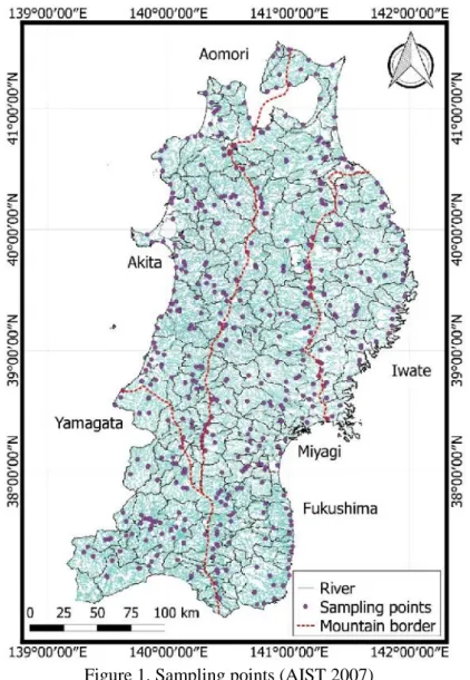
The study area is located in the Tohoku region in the northern part of the Japanese island of Honshu (36° 54' N to 41° 29' N, 139° 33' to 141° 58' E). A total of 485 total concentration (TC) data for 53 elements from river sediment in the region were considered in this study (Figure 1). The data were derived from the Geochemical Map of Japan developed by the Geological Survey of Japan (AIST 2007).
To observe the geological influence on the elemental composition, a geological map derived from a seamless digital map produced by the Geological Survey of Japan (AIST 2003) was
incorporated into the analysis. This study also incorporates ore deposit distribution data from the Geosphere Environmental Informatic Universal System (GENIUS) Ver. 1.02 (GSES 2011). Furthermore, as the basis for source determination, this study incorporated a land-use map from the Geospatial Information Authority of Japan (GSI 2006). Finally, those databases were re-analyzed and synthesized into the comprehensive data sets using an original method applying GIS and statistical analysis in this study. The GIS method overlays numerous spatial data prior to the multivariate analysis and calculated distribution function.
Figure 1. Sampling points (AIST 2007)
2.3. Methodologies
The samples, assigned by GSJ (2010), were extracted using HNO3–HClO2–HF and analyzed to obtain the total elemental concentrations by inductively coupled plasma atomic emission spectroscopy (ICP-AES), inductively coupled plasma mass spectroscopy (ICP-MS), and atomic absorption spectroscopy (AAS).
To understand the origins and distribution mechanisms of the considered elements, multivariate analysis was applied to the geochemical data. Pearson correlation was applied to illustrate the correlation of the elements. PCA decomposes the geochemical features as a set of scores and coefficients, which respectively describe the eigenvector for each sampling point and that for each element (Jolliffe and Cadima 2016; Ringnér 2008).
Geochemical Background (GB) is defined as a categorical variable with several possible values not only in the whole region but also in particular area classifications. The GB category was assigned values using the calculated distribution function method (Matschullat et al. 2000). In this method, the original dataset in each category is first reduced by eliminating all data exceeding the median concentration. The reduced dataset, which consists of values below the median, is then mirrored about the median to construct the calculated dataset. In this study, the GB was classified into four categories: namely the GB for the general area (GGB), the natural background (NGB), the anthropogenic background (AGB), and the GB in mineralized areas (MGB),
2.4. Results and discussions
2.5.1. Geochemical distribution mechanisms
Geochemical distribution in Tohoku Region shows that the median concentrations of major elements were lower than their mean values, except for those of Al2O3 and MgO. The average
concentrations of all the trace elements were higher than their median concentrations.
The Pearson correlation (r < 0.05) was applied to investigate the correlation among the target elements. The chalcophile elements, excluding As, Ga, and Hg, showed strong correlations with one another, with correlation coefficients ranging from 0.67 to 0.98. Most of the light REEs were moderate to strongly correlated.
PCA results are analyzed to observe the distribution mechanisms and origin of elements in the Tohoku Region. In this study, four significant PCs (PC1 – PC4) were observed since their eigenvalues reach 65.3% of the total variance. PC1 accounts for 25.3% of the total variance. It yielded significantly higher coefficients for the REEs than the other elements. High PC1 scores occurred especially in Abukuma area and in Osarizawa where sericite zone is located. The abundance of REEs is widely associated with local parent rocks and minerals. Thus, the origin of REEs in the observed area is likely to be related to the occurrence of the huge granitic igneous rocks as the basement zone.
PC2 accounted for 16.7% of the total variance. High PC2 scores were observed in Mutsu (11.00) and Kazamaura (8.70) on the Shimokita Peninsula, Aomori Prefecture. PC2 can be considered to describe the interaction of incompatible elements in mafic rocks. The eigenvectors of PC2 have positive scores for elements compatible with mafic rocks. The incompatible elements tend to have negative PC2 scores, indicating the absence of elements in areas where mafic and ultramafic rocks occur. In addition, siderophile elements were also observed to occur in urban areas, such as Morioka
and Hanamaki where previous studies have observed metal enrichment due to urban contamination (Haris and Aris 2015; Islam et al. 2015; Mielke et al. 2000; Rossi et al. 2013).
PC3 accounted for 13.9% of the total variance and was strongly characterized by high coefficients for most chalcophile elements especially in Osarizawa and few cities in the Yoneshiro river basin. These cities are located in the Hokuroku basin, where kuroko- and vein-type deposits occur where enormous Pb, Cu, Zn, Au, and Ag mines were located. (K Hattori and Sakai 1979; Keiko Hattori and Muehlenbachs 1980; T. Sato 1977). Therefore, ore deposits may act as an origin of the chalcophile elements. In addition, PC3 results also give an indication of the impact of mining activities, for instance in Osarizawa (Arribas and Mizuta 2018; Kunito et al. 1997; Machinda et al. 1983).
PC4 accounted for 9.3% of the total variance. PC4 coefficients were predominantly high for siderophile and lithophile elements, especially Co, Ni, Fe2O3, Cr, MgO, and V. Furthermore, high PC4
scores were found in some volcanic and igneous rocks, such as Mutsu and Osarizawa. Sc, Co, V, and Cr are present in high concentrations in mafic volcanic rocks, as in Mutsu and Kazamaura. Similar eigenvector directions are likely to be obtained for Cr, Co, and Ni due to their compatibility with mafic rocks. Those conditions are likely related to their lower mobility in Fe-rich environments, especially under circumneutral conditions (Smith and Huyck 1999).
2.5.2. Geochemical background values
The calculated distribution function was applied to determine GB values. All major elements obtain the highest upper-bound values for NGB than other GB types. This may indicate that the predominant source of major elements is based on the natural conditions.
In terms of the GB for the lithophile elements, the results illustrate various enrichments are likely to occur in mineralized and natural areas. Among the siderophile elements, Co and Ni are likely enriched in the natural geo-genic sources, while Mo is enriched in anthropogenic area. The chalcophile elements tend to concentrate either in natural or mineralized areas. Zn, Cd, Sb, Pb, and Hg present higher MGBs than those for other GB types. Cd and Zn obtain identical GB values, which remain great correlation in terms of their distribution within all Tohoku Region. As the pathfinder elements, Sb also shows particular higher values in the mineralized area. These conditions are in accordance with Ujiie-Mikoshiba et al. (2006) that those elements are in coincidence with the distribution of ore deposits.
GB differentiations into natural, anthropogenic, and mineralized areas provide appropriate objective GB ranges including spatial factors. Furthermore, the GB differentiation used in the present study could provide the basis for recommendations for contamination assessment in more specific sites. As a result, the policymakers could establish more sustainable rehabilitation action in the urban area based on the particular contaminants influencing the geochemical signatures (Chambers et al. 2016).
2.5. Conclusions
In this study, a multivariate analysis was conducted, and the GB was established for 53 elements in the Tohoku region. Based on the multivariate analysis results, it was found that the elements were originated from various natural sources, with many related to particular geological features and ore deposits. It was shown that igneous rocks tend to predominantly influence the distribution and association of the elements. The natural influence of geological features was shown in the distribution of siderophiles, lithophiles, and chalcophiles. In addition to the natural geogenic occurrence, anthropogenic sources were shown to influence the distribution of heavy metals. The overall results of the multivariate analysis show that the geochemistry of river sediments in the Tohoku region is more strongly influenced by natural sources than anthropogenic sources.
The geochemical background of most elements showed high upper range values in natural and mineralized areas, indicating that the influence of geogenic enrichment is related to parent rocks or ore deposits. The differentiation of the GB used here is expected to be useful in further environmental research to perform more objective contamination assessment. The GB of the Tohoku region may indicate the existence of positive anomalies corresponding to ore deposits and confirm the geogenic sources of elements.
Chapter 3. Environmental Assessment of Particular Mineralized Area Sites
3.1. Background
As already mentioned in Chapter 2, the distribution of elements is predominantly influenced by geo-genic factors, for examples, the distribution of igneous rocks, the existence of ore deposits, and the interaction between the mineral-rich area. Furthermore, some anthropogenic sources of elements are also recognized as the distribution mechanisms of elements, for examples mining and urban areas. In this chapter, two cities are designated as the target study area, namely Kesennuma and Sendai City which represents the massive post-mining city and urban area, respectively.
Kesennuma City in Miyagi Prefecture has been recognized as a mining city, located in the north-eastern part of the prefecture. The City was acknowledged for its metal-bearing minerals generating several precious metal products, for instances, gold, silver, and copper. The presence of mineral deposits in Kesennuma City has generated some influences on the environmental (Miura et al. 2013; C. Sato et al. 2014). Apart from past studies, little has been discussed regarding the geochemical assessment of comprehensive environmental media in Kesennuma City. Therefore, the complete understanding of geochemistry and human health risk in Kesennuma City is still questionable and necessary to observe.
Sendai City is capital of Miyagi Prefecture, which is also recognized for ore productions, for instances silver, copper, lead, zinc, and iron deposits. The contribution of mining, agricultural, and urban activities in Sendai City has brought concerns to environmental quality (Nakamura, Sato, et al. 2016). However, the study only decomposed the target elements. Thus, the possibility of wider natural and anthropogenic mechanisms occur, since fewer elements were incorporated into the study.
3.2. Objectives
The objectives of this study are (1) to observe the distribution and enrichment of potentially toxic trace elements, (2) to establish the geochemical background values of the elements, and (3) to assess the potential human health risk from the exposure to the elements in environmental media of mining and urban cities.
3.3. Study area
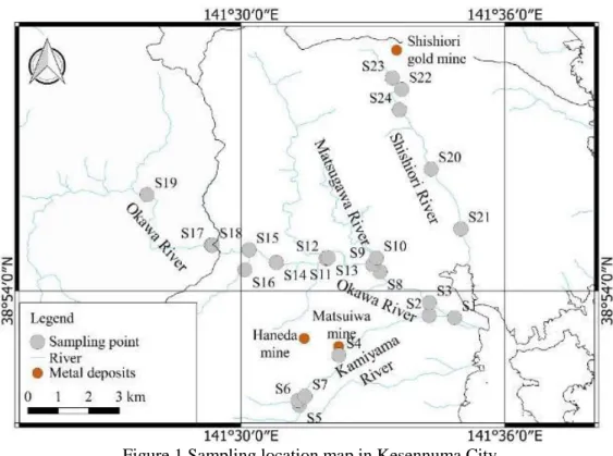
The study area of mining city is located in Kesennuma City, Miyagi Prefecture in Japan (Fig. 1). The city mostly consists of a natural area which is covered by natural vegetation types, for instances evergreen needle leaf and mixed forests (GSI 2006). Geological setting of Kesennuma City shows the importance of sedimentary rocks as the basement zone. The distribution of gold deposits in Kesennuma City is associated with the distribution of Cretaceous granitoids in the Kitakami Mountains. The
extensive gold deposits in Kesennuma city resulted in the mass production of gold-silver-copper production in several mines, for instance Oya, Shishiori, and Matsuiwa mines.
Figure 1 Sampling location map in Kesennuma City
Sampling locations in Kesennuma City are located along three river basins, Okawa River, Shishiori River, and Kamiyama River (Figure 2). Samples of river sediment and river water were collected in 24 points, while those of soils were collected in 23 points. Sampling collection was performed in 2017.
Sendai City, the capital of Miyagi Prefecture, is applied as the case study of the urban area. Sendai City comprises of both natural forest and urban activities, lying from the west side into the east side. Geological setting of Sendai City shows systematic variations from west to east and the contribution of Ou Mountain ranges and Abukuma massive (AIST 2003). Ore deposits are also recognized in numerous areas of Sendai City; for instances iron sand deposits in Kabazawa mine, silver, copper, lead, zinc, and iron deposits in Akiu mine, and silicate and copper minerals in Okunikkawa area (GSJ 2012; Hanzawa et al. 1953; Tani and Saito 1961).
Sampling locations in Sendai City are located along two river basins, Hirose River and Natori River (Figure 3). Data were adapted from Nakamura, Sato, et al. (2016) that taking samples in 15 points along Hirose River and 13 points along Natori River on 2015.
3.4. Methodologies
Geochemical analysis were performed in this study to achieve the objectives. The purposive samples were applied to all cities so that the samples could consider possible contamination sources, land use types, and river tributaries. Furthermore, topsoils of 0-20 cm depths in 23 locations were collected using stainless steel scoop and placed in sterile PE bags. Along the rivers, 24 surface water samples were taken from around 10 cm depths using 100 mL PE bottles. All bottles were rinsed three times by the river water prior to the collection. Each point applied two types of water samples, the non-preserved sample, and preserved sample. The preserved samples were added by 1 mL of concentrated HCl to achieve pH <1. Moreover, sediment samples were also collected in the same locations of the water sampling using a stainless steel scoop or a portable Ekman grab sampler. The sediment samples were placed in PE bags and soon transported to the laboratory. Afterward, the water samples were filtered using 0.45µm membrane filters. The soil and sediment samples were air-dried until achieving stable weights. The samples were sieved using 2 mm strainer and stored in the PE bags for further sample preparation and analyses.
Total concentration (TC) of the following 8 trace elements were determined for all samples: Arsenic (As), Cadmium (Cd), Copper (Cu), Chromium (Cr), Nickel (Ni), Lead (Pb), Antimony (Sb), and Zinc (Zn). The bulk samples of soil and sediment were following the method by Matsunami et al. (2010) using Energy Dispersive X-ray Fluorescence (EDXRF) spectrometry (PANalaytical Epsilon 5). Total concentration of river water is determined using Inductively Coupled Plasma Mass Spectrometry (ICP-MS; ELAN9000, Perkin-Elmer) incorporating indium (In) as an internal standard.
To evaluate leaching abilities of elements from soil and sediment, single leaching procedures were performed. The procedures consist of water and acid leaching tests following the methods by Japan Ministry of the Environment (2002). The filtrates were then analyzed to determine the Water Leaching Concentration (WLC) and Acid Leaching Concentration (ALC), respectively, using Inductively Coupled Plasma Mass Spectrometry (ICP-MS; ELAN9000, Perkin-Elmer) incorporating
indium (In) as an internal standard (Nakamura, Kuwatani, et al. 2016). pH and Electrical Conductivity (EC) of soils and sediments were analyzed from the filtrates of water leaching procedure.
Geochemical background (GB) was determined using a calculated distribution function to eliminate the outliers of a data set (Matschullat et al. 2000). The principle of the outlier omission is by converting the original data which is higher than the median values, into a new data set.
To evaluate the contamination status of target elements in the environment, this study performs Index of Geo-accumulation (Igeo) calculation the method by Muller (1969) and status by Bhuiyan, Parvez, et al. (2010).
Potential non-carcinogenic and carcinogenic risks of trace elements in multi environmental media were identified by human health risk assessment. The assessment consists of hazard identification, dose-response assessment, exposure assessment, and risk characterization. Eight potential toxic elements were selected, namely As, Cd, Cu, Cr, Ni, Pb, Sb, and Zn. The exposure pathways of elements were derived from each environmental medium and each assigned routes, namely ingestion, inhalation, and dermal contact. The receptors were defined as the general population with some differential for non-carcinogenic and carcinogenic risks. Receptors for non-carcinogenic risk characterization were defined as child and adult. While those for carcinogenic risk characterization was determined only as a resident (US EPA 2011). In dose-response assessment, toxicity values of the target elements were determined from previous studies. The toxicity values were defined as Reference Dose (RfD) and Reference Concentration (RfC) for non-carcinogenic risk, and oral Slope Factor (Oral SF) and inhalation Slope Factor (Inh SF) for carcinogenic risk (US EPA 2002a, 2005). Furthermore, the exposure assessment was performed by observing Chronic Daily Intake (CDI, mg/kg-day) following the method by US EPA 1989). Moreover, the risk characterization was observed by determining Hazard Quotient (HQ) and Hazard Index (HI) for the non-carcinogenic risk and Risk value for the carcinogenic risk (US EPA 1989, 2002b, 2005):
3.5. Results and discussions
3.5.1. Mining area: Kesennuma City
The distributions of elements in the observed environmental media may elucidate diverse conditions in each river basin. The enrichments in Okawa River basin are in coincident with the location of a natural area around mafic rocks basement zone and anthropogenic areas around urban and agricultural areas. Along the Kamiyama river basin, the influences of ore deposits and past mining activities are likely to reveal around Matsuiwa mines (S04). While increasing concentrations of As, Cr, and Ni along Shishiori River basin were observed in the area at the downstream of the Shishiori gold mines and in the area of ex-smelter. Some of the results are in accordance with previous studies (Miura et al. 2013; C. Sato et al. 2014).
from surficial media into the groundwater. As noted in the results, considerable leaching potentials were appeared mostly in the middle (S13) and downstream (S01) of Okawa River basin, middle (S04) and downstream (S03) of Kamiyama River basin, around the Shishiori mines, and in the middle stream (S20) of Shishiori River. Water leaching concentration results of Sb and Zn in soil and sediment were very low which likely representing their low mobility. Kabata-Pendias and Mukherjee (2007) summarized that the mobility of Sb in soil and sediment is very low due to their strong affection with Al, Mn and Fe particulates.
Furthermore, acid leaching concentration (ALC) results for soils show that all elements are extractable within the detection limits. The acid leaching concentrations demonstrates the potential concentration of elements in human digestion. Considerable leaching potentials were mostly found in the area of contamination, for instance in the downstream of Shishiori and Okawa river basin, and in the vicinity of Shishiori and Matsuiwa mines. These results are in accordance with (Nakamura, Sato, et al. 2016) that the acid leaching concentrations were closely associated with the elemental abundance in particular environmental media.
The geochemical background values in Kesennuma City shows that arsenic has the greatest discrepancies between theoretical and original GB. These results could explain that great amount of contaminations are probably to occur in soil, river sediment, and river water of Kesennuma City. The other elements present quite similar information in lower amounts, for examples Cd and Pb in river sediments, and Cu, Cr, and Ni river water. The geochemical background values calculated in this study could be useful to apply in other contamination assessment of a particular area in Kesennuma City.
The contamination evaluation by Index of Geo-accumulation incorporates river sediment data since it could represent both geo-genic and anthropogenic sources of elements. Even though Igeoresult
around Matsuiwa mine shows moderately contaminated, most of areas are relatively uncontaminated. Thus, compared to another area in the Tohoku Region, Kesennuma City shows relatively uncontaminated in most sampling points in the study area. Thus, the
To observe the distribution mechanisms and origin of elements, multivariate analysis of major and trace elements was performed. The incorporation of major and trace elements gives more inclusive information, including the role of geo-genic factors to the distribution of elements. River sediment in the city is dominantly consisted of SiO2, Al2O3and Fe2O3. The abundances of those minerals elucidate
numerous conditions, for examples resistant primary minerals dominate the composition of river sediments, materials formation from the secondary phase during the chemical weathering, and less solubitility due to silicate minerals (Gaillardet et al. 2003; Viers et al. 2009). Furthermore, average concentrations of As and Cu in Kesennuma City are higher than those in the Tohoku Region. This condition is likely related to the abundance of As and Cu deposits in Kesennuma City.
Results of PCA show that geo-genic factors give more predominant influence on the origin of elements. PC1 to PC4 show significant eigenvalues of 81.8% of the total variance. PC1 accounts for
instances mining and urban depositions, felsic and mafic rocks basement zone, and also calcareous surface materials in Okawa River and Kamiyama River. Further anthropogenic deposition and geo-genic origins of elements are also recognized from the results of PC2 (16.9% of total variance), for examples the occurrence of Na2O, Th, Sn, Pb as influences of granitic rocks mineralization, and P2O5
and Sn from agricultural activity. Possible contamination path from past mining activities and the influence of Kitakami granite are clearly expressed from the PC3 results (9.6% of the total variance). The possibilities are derived from the high positive eigenvectors of Ni, Pb, and Cs and high scores in all sampling points along Shishiori River. Whereas results from PC4 (8.3% of total variance) show alike mineral-related and pathfinder elements (Cu, As, Pb) around Matsuiwa Mine. In addition, the distribution mechanisms of elements in Kesennuma city could be concluded based on each river basin area.
The average results of non-carcinogenic risk of all elements obtain not adverse risk in each media for all receptors due to the average HI values for all elements were less than 1. Moreover, less attenuation of As in Shishiori River is likely to pose a non-carcinogenic risk to humans. On the other hand, the results of carcinogenic risk showed that the average risk value for As in soil obtains unacceptable risk since the value was as higher than 1x10⁻⁵especially around Shishiori and Matsuiwa
mines. In terms of arsenic risk to humans, the predominant route of arsenic exposure in Kesennuma City is the soil to the groundwater pathway wich is in accordance with (ATSDR 2007; Hadzi et al. 2018a; Nordstrom 2002). In accordance with the contamination sources of the elements, it can be concluded that the mining area and downstream urban area in Kesennuma City are prone to health risk issues. The vicinity of mining area tends to be very susceptible to the potential health risks. Thus, it is important to present concerns of post-mining management. The estuary is also an important consideration since the industrial and municipal wastes are considerably produced and deposited around the downstream region.
3.5.2. Urban area: Sendai City
Total concentration results in river sediment of Sendai City obtain Zn as the most abundant element among the target elements. All mean concentrations are lower than those of Tohoku Region, except for Sb. In terms of distribution patterns, numerous pairs of elements show similar patterns, for example As-Sb, Cu-Zn, and Cr-Ni. Most of their concentrations are higher in upstream areas and lower in downstream areas.
Geochemical Background values (GB) of river sediment in Sendai City shows huge discrepancy of Sb. The discrepancy is likely to present as contaminations in river sediment of Sendai City. The GB result is in accordance with Igeo results which the highest index value obtains for Sb. This contamination evaluation which incorporates GB values of Tohoku Region could support that Sb enrichment is likely to result in moderate contamination in Sendai City.
Multivariate analysis of major and trace elements is also applied to observe the distribution mechanisms and origin of the target elements. General geochemical distribution in Sendai City shows that primary minerals develop sediment materials in secondary phases during chemical weathering due to the domination of . Thus, the domination of SiO2, Al2O3, and Fe2O3. In addition, SiO2 tends to
obtain less soluble sediment materials (Gaillardet et al. 2003; Viers et al. 2009). Furthermore, among the heavy metals from Siderophile and Chalcophile groups, Zn and Cu dominate the composition in river sediments.
Four significant PCs are considered to observe the distribution mechanisms and elemental origins. Cumulative eigenvalues of PC1 to PC4 account for 75.7 % of the total variance. PC1 accounts for 39.5% of the total variance, showing significant information about geo-genic sources of elements in felsic and mafic rocks intrusive, for instances CaO, Co, Fe2O3, TiO2, MnO, V, and Sr elucidate the
influence of felsic and mafic rocks intrusive. PC2 accounts for 20.9% of the total variance, signifying the influences of omnipresent heavy minerals which are observed on the upstream of Natori and Hirose Rivers, and the discrepancy between loamy (Zr, Ce, Nd) and sandy surface materials (SiO2) in the City.
Moreover, PC3 which accounts for 9.6% of the total variance, expressing the influences of felsic intrusive (Y, Cs) and mafic intrusive (Cu, Zn, MgO) as part of the Igneous basement zone along Ou backbone ranges in Sendai City (Hanzawa et al. 1953; R. Salminen et al. 2005). In addition, PC3 also shows the abundance of some potential contaminants from chalcophile and siderophile groups in the middle and downstream area. Moreover, PC4 (5.7% of the total variance) presents possible anthropogenic contaminations of As, Sb, MnO, Cu, and Zn from the urban environment in the middle stream of Hirose River.
The abovementioned multivariate analysis results eventually could describe the distribution mechanisms of elements in Sendai City. In general, distribution mechanisms of elements in Hirose and Natori Rivers are quite similar. The upstream parts of the rivers are influenced by geo-genic materials, followed by numerous anthropogenic sources.
The non-carcinogenic results show that all elements are likely to pose non-adverse risks to adults. On the other hand, Pb represents the only element which could pose an adverse risk to children. Since the previous multivariate analysus result concludes that Pb is likely originated from anthropogenic activity Sendai City, it could be implied that the risk is an urban-type occurrence which is in accordance with (Markus and McBratney 2001; Ngure et al. 2014; Reimann et al. 2012).
3.6. Conclusions
Based on the results from previous chapter, significant enrichment of anthropogenic origin elements is observed in mining areas and some parts in urban-mineralized areas. Thus, this chapter aims to perform environmental assessment representing those environments towards post-mining rehabilitation strategies in Kesennuma City and Sendai City as mining and urban areas, respectively.
The environmental assessment of Kesennuma City is the initial attempt to perform comprehensive assessment towards post-mining rehabilitation strategy. Pathfinder elements (As and Sb), Cu, and Ni are enriched around gold and copper mining areas. Generally, influences of igneous basement zone contribute widely to the elemental distribution, both as geo-genic mechanisms and anomalies from significant ore deposits. On the other hand, anthropogenic origin from mining and urban activities may also be responsible for the deposition of elements in the downstream region. This condition eventually results in harmful effects of As to human health, both as non-carcinogenic and carcinogenic risks.
Furthermore, environmental assessment in Sendai City describes geo-genic and urban influences on the environment. Most elements show increasing concentrations in middle stream areas and good attenuation near the coastal areas. Igeo and geochemical background values indicate Sb
contamination in Sendai City. Furthermore, even though distributions of major and trace elements are predominantly affected by the geo-genic origin of igneous basement zone, urban and agricultural activities develop important anthropogenic impacts on the distribution of heavy metals in river sediment. In addition, Pb and As may pose adverse non-carcinogenic risk and unacceptable carcinogenic risk, respectively. This study suggests significant attentions of environmental monitoring of Sb, Pb, and As contamination around urban areas in Sendai City.
Chapter 4: Land Rehabilitation Strategy Decision Making based on
Environmental and Human Health Risk Approaches
4.1. Background
As mentioned in Chapter 1, the land rehabilitation of post-mining area focuses on altering the functions of post-mining land into other suitable land utilization. Thus, this study incorporates environmental and human health considerations into the rehabilitation criteria. The alterations of the post-mining area include returning the site into the nature that prevents human interfere, or to perform human service provisions that give valuable and sustainable functions to human beings (Haigh 2007). However, fewer studies have defined the principles of these two methods in rehabilitation decision making.
Previous research also shows numerous statistical dichotomy decision tools to build rehabilitation decision making, especially Multi-Attribute Decision-Making (MADM) and Index decision making models (Kubit et al. 2015; Masoumi et al. 2014; H. Soltanmohammadi et al. 2008; Hossein Soltanmohammadi et al. 2009, 2010). However, little studies incorporate both site prioritization and rehabilitation method ranking. Ranking of both items could help mining stakeholders to manage their resources towards sustainable rehabilitation goals. Thus, the new methodology for making the decision of post-mining rehabilitation strategy is proposed, based on the approaches of environmental and human health risk.
4.2. Objectives
The objective of this chapter is to develop a novel model of rehabilitation strategy decision making in the vicinity of post-mining area incorporating environmental and human health risk approaches. To achieve this objective, this chapter attempts (1) to create a model for rehabilitation decision making, and (2) to evaluate the land-rehabilitation model by applying to the case study.
4.3. Rehabilitation decision-making model
The proposed post-mining land rehabilitation decision model consists of chronologic modeling procedures. The procedures are (1) rehabilitation attribute determination, (2) site prioritization for rehabilitation, and (3) rehabilitation method screening process. Those procedures incorporate numerous attributes and factors. Thus, particularly statistical methods are necessary to build relevant considerations of all designated considerations, such as Analytical Hierarchy Process (AHP) and Technique for Order of Preference by Similarity to Ideal Solution (TOPSIS). Since the rehabilitation decision-making model concerns highly on environmental and human health risk assessment, the rehabilitation attributes are limited to only technical and environmental issues.
To decide the suitable land rehabilitation strategies for particular sites, MADM was performed by assigning correspondence criteria. In terms of the criteria, this study develops the typical decision tree for the criteria and indexing calculation for the final rehabilitation score.
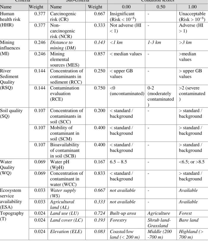
Table 1 Final proposed attribute weight and score for post-mining rehabilitation strategies
Criteria Sub-criteria Condition scores
Name Weight Name Weight 0.00 0.50 1.00
Human health risk (HHR) 0.377 Carcinogenic risk (CR) 0.667 Insignificant (Risk < 10⁻⁵) - Unacceptable (Risk > 10⁻⁵) 0.377 Non-carcinogenic risk (NCR)
0.333 Not adverse (HI < 1) - Adverse (HI > 1) Mining influences (MI) 0.246 Distance to mining (DM) 0.143 <1 km 1-3 km >3 km 0.246 Mining elemental sources (MES)
0.857 < median values - >median values River Sediment Quality (RSQ) 0.144 Concentration of contaminants in sediment (RCC) 0.250 < upper GB values - > upper GB values 0.144 Contamination evaluation (RCE) 0.750 <0 (uncontaminated) 0-2 (moderately contaminated ) >2 (severe contaminated ) Soil quality (SQ) 0.107 Concentration of contaminants in soil (SCC) 0.200 < standard / background - > standard / background 0.107 Mobility of contaminant in soil (SCM) 0.400 < standard / background - > standard / background 0.107 Bioavailability of contaminant in soil (SCB) 0.400 < standard / background - > standard / background Water Quality (WQ) 0.069 Water pH (WpH) 0.167 6.5 – 8.5 - <6.5; or >8.5 0.069 Concentration of contaminant in water (WCC) 0.833 < standard / background - > standard / background Ecosystem service availability (ESA) 0.033 Water supply (WS)
0.667 not available - Available
0.033 Agricultural land (AL)
0.333 not available - Available
Topography (T)
0.024 Land use (LU) 0.724 Built-up area Agriculture Forest
0.024 Land cover (LC) 0.193 Forestry Shrub land-Grassland
Bare land
0.024 Elevation (ELE) 0.083 Coastal/low land (< 200 m)
Middle (200 -700 m)
Highland (> 700 m) Italic attributes describe benefit attributes.
The attributes of land-rehabilitation model consist of numerous criteria. As we assigned the environmental and human health risk approaches to the land-rehabilitation model, the attributes consider factors related to those approaches. Reviews of previous literature and results from previous chapters propose seven criteria, namely water quality, soil quality, river sediment quality, mining influences, human health risk, ecosystem services availability, and topography. The sub-criteria are also established for each criterion.
In the MADM model, each attribute has a different weight than others. The differences are associated with their different influences in land rehabilitation of the mining area. The determination of attribute weights performs Analytical Hierarchy Process (AHP) which was originally proposed by Saaty and Vargas (1994). The proposed attribute weight and score from AHP method are illustrated in Table 1 .
For decision-makers, site priority ranking towards rehabilitation strategy is necessary to conduct due to different impact magnitudes from mining and limited rehabilitation resources. Thus, this study applies the rehabilitation priority ranking method. All associated data are calculated for their weights and scores following the method of Criteria Score by Kubit et al. (2015). The Criteria Score status is defined as low, medium, and high priority.
After defining the rehabilitation attributes and rehabilitation priority ranking, the next step is to rank the rehabilitation strategy ranking. This procedure aims to choose which rehabilitation method suitable to the target site. Prior to the calculation, the rehabilitation strategies are defined into five general methods, namely Natural Ecosystem (NE), Agricultural/Biomass production (AB), Water Supply (WS), Green-spaces (GS), and Built-environment (GE)
To determine the suitable rehabilitation method for the site, Technique for Order of Preference by Similarity to Ideal Solution (TOPSIS) proposed by Hwang and Yoon (1981) is applied. The principle of TOPSIS is to statistically determine preference order based on the contribution of each criterion to the proposed strategies.
4.4. Case study: Kesennuma City
The proposed method was evaluated by applying all steps to some sites as a particular case study. The environmental and human health risk assessment results for Kesennuma City in Chapter 3 are incorporated as the sub-criteria input data in TOPSIS method. Kesennuma City is determined as the case study since it obtains the requirement as post-mining and mineralized areas. Even though central urban areas have been designated as the built-environment, the geoscience information is feasible to determine the suitable rehabilitation strategies.
The results show that there are four sites occur as a high priority for rehabilitation, located in the downstream area and in Shishiori River Basin. Furthermore, there are each 10 sites for medium and low priority area to rehabilitate. The upstream area of Shishiori shows low priority, while all points
Acceptability of the proposed method is evaluated by comparing the proposed rehabilitation results with land-use plan (Kesennuma City 2018) and actual land use in the city. As much as 18 points or 75% area remain compliment results between the proposed methods and the land uses. All points with high priority for rehabilitation obtain compliment results. For each site, two alternatives are proposed due to the flexibility of decision making. Since rehabilitation has a concern to incorporate several types of decision-makers, the alternative methods may open the opportunity to choose which statistically and scientifically suitable method is. Based on 75% conformities between the proposed methods and land use in Kesennuma City, the overall proposed rehabilitation strategy decision-making models are likely feasible to apply for further studies.
4.5. Conclusions
This chapter proposed an original model towards rehabilitation decision making for post-mining and mineralized areas based on the environmental and human health risk approaches. The models attempt to define attributes, site priority ranking, and method ranking of rehabilitation strategies. The decision-making models are based on the integration of Multi-Criteria Decision-Making (MCDA) process and index models. Several statistical decision tools are performed, for examples Analytic Hierarchy Process (AHP) to determine the attribute weights, index score to rank the site priority, and Technique for Order of Preference by Similarity to Ideal Solution (TOPSIS) to rank the rehabilitation method.
The proposed attributes for rehabilitation decision models consists of seven criteria and 16 sub-criteria. The criteria are water quality, soil quality, river sediment quality, mining influences, human health risk, ecosystem services availability, and topography. Based on the designated weights by AHP, human health risk and topography obtain the highest and the lowest weights, respectively.
This chapter applies environmental and human health risk data of Kesennuma City as the case study to evaluate the proposed models. The information and data used in this evaluation are originated from Chapter 2 and Chapter 3. The results of site priority ranking show that four sites around mining and downstream urban area obtain high priority for rehabilitation. The evaluation results for the rehabilitation method ranking show 75% conformity with land-use in Kesennuma City. Thus, the proposed rehabilitation decision-making models are likely feasible to apply for further studies. In addition, the model and methodologies could be applied universally for the evaluation of environmental rehabilitation strategies in any situation.
Chapter 5. Conclusions
5.1. Conclusions
In this study, the original methodologies necessary for post-mining rehabilitation strategy decision-making of mineralized areas have been proposed. The decision-making model incorporates environmental and human health risk approaches. To perform this objective, basic geochemical assessment and specific environmental assessment are conducted. The results of the assessment are incorporated to evaluate the proposed rehabilitation model.
In Chapter 2, this study conducts a basic geochemical assessment of wider mineralized area as the background condition. Tohoku Region is determined as the study area due to the considerable mineral deposits and past mining activities. The distribution of elements in the Tohoku Region is predominantly driven by geo-genic sources, especially the influences of wide igneous rocks as the basement zone. Furthermore, anthropogenic activities also control the distribution of elements especially in mining and urban areas. In addition, four types of Geochemical Background (GB) are established in this study, namely general GB, natural GB, anthropogenic GB, and GB in the mineralized area. The theoretical GB of Tohoku region may indicate the existence of positive anomalies corresponding to ore deposits and confirm the geogenic sources of elements.
Chapter 3 performs the environmental assessment of a specific area in mining and urban cities. Kesennuma City and Sendai City are determined as the case studies of mining and urban environment, respectively. The study shows numerous differences in enrichment, the origin of elements, and potential human health risks between those city types. In Kesennuma City, contaminants are deposited in descending elevations from mining to downstream areas. Attenuations are less significant since the enrichment are still recognized in the downstream parts. Most contaminants are mining and mineral pathfinder elements, especially arsenic. The enrichment of arsenic is significant that creates the discrepancy between the original and theoretical GB. Geo-genic factor dominantly controls the distribution mechanisms of elements, followed by past mining and urban activities. Eventually, the potential human health risk is observed due to the exposure to arsenic from environmental media in numerous areas of the city. Moreover, the environmental assessment in Sendai City shows geo-genic and urban influences on the environment. The enrichment appears as some depositions, located around river confluences, around agricultural and urban areas. Good attenuation in the downstream area is observed. Sb is likely to generate contaminations in river sediment and some discrepancy between original and theoretical GB. Besides the dominant geo-genic origin, anthropogenic activities from urban and agricultural areas also control the distribution of elements. In addition, significant human health risks are observed due to the exposure to As and Pb.
post-evaluation, in order to make clear ranking and decision matrix. The incorporation of these approaches is likely useful towards the sustainable rehabilitation targets, as more human-use or return-to-nature strategies. The decision-making models consist of attribute determination, site priority ranking, and rehabilitation method ranking. The attributes, related to the environment and human health risk approaches, consist of seven criteria with its own sub-criteria and conditions. The designated criteria are human health risk, mining influences, river sediment quality, soil quality, water quality, ecosystem service availability, and topography. All attribute weights and scores are then calculated to rank the site priority. Afterward, the rehabilitation methods are ranked to choose the priority among five options, namely return-to-nature, water supply, food and biomass production, built environment, and green spaces. Evaluation of the models applies the environmental data of Kesennuma City. The results of site priority ranking show that two sites in around mining and downstream urban area obtain high priority for rehabilitation. The evaluation results for the rehabilitation method ranking show 75% conformity between the evaluation results with land-use in Kesennuma City. Thus, the proposed rehabilitation decision-making models are likely feasible to apply for other studies.
In overall, the proposed rehabilitation strategy is likely recommended as one of the post-mining recovery strategies due to its sustainability of post-mining implementation. This specific approaches of environment and human health risk may illustrate the importance of geoscience studies in the decision-making process for stakeholders. This study also found important roles in implementing the preliminary assessment of the mineralized area prior to the rehabilitation strategy development. Thus, the preliminary assessments generate consecutive relationship among all research steps.
5.2. Recommendations
Based on the overall results, this study recommends several points as follow:
1. to incorporate the suitable geochemical background values to other studies in Tohoku Region; 2. to consider not only an environmental consideration but also human health risk approach in
rehabilitation strategy decision making; and
References
(ATSDR) Agency for Toxic Substances and Disease Registry. (2007). Toxicological profile for arsenic (update), (August).
AIST. (2003). Seamless Geological Map of Japan. https://gbank.gsj.jp/seamless/seamless2015/2d/index.html. Accessed 31 March 2018
AIST. (2007). River sediment geochemistry of Tohoku Region. Geological Survey of Japan, AIST. https://gbank.gsj.jp/geochemmap/data/data.htm. Accessed 27 July 2017
Aronson, J., Clewell, A. F., Blignaut, J. N., & Milton, S. J. (2006). Ecological restoration: A new frontier for nature conservation and economics. Journal for Nature Conservation, 14(3–4), 135–139.
doi:https://doi.org/10.1016/j.jnc.2006.05.005
Arribas, A., & Mizuta, T. (2018). Potential for Porphyry Copper Deposits in Northern Tōhoku (or the Exploration Potential for Base and Precious Metal Deposits in Japan 2020). Resource Geology, 68(2), 144–163. doi:10.1111/rge.12167
Beames, A., Broekx, S., Lookman, R., Touchant, K., & Seuntjens, P. (2014). Sustainability appraisal tools for soil and groundwater remediation: How is the choice of remediation alternative influenced by different sets of sustainability indicators and tool structures? Science of the Total Environment, 470–471(2014), 954– 966. doi:10.1016/j.scitotenv.2013.10.044
Bhuiyan, M. A. H., Parvez, L., Islam, M. A., Dampare, S. B., & Suzuki, S. (2010). Heavy metal pollution of coal mine-affected agricultural soils in the northern part of Bangladesh. Journal of Hazardous Materials,
173(1–3), 384–392. doi:10.1016/j.jhazmat.2009.08.085
Chambers, L. G., Chin, Y. P., Filippelli, G. M., Gardner, C. B., Herndon, E. M., Long, D. T., et al. (2016). Developing the scientific framework for urban geochemistry. Applied Geochemistry, 67, 1–20. doi:10.1016/j.apgeochem.2016.01.005
Chandrajith, R., Dissanayake, C. B., & Tobschall, H. J. (2001). Application of multi-element relationships in stream sediments to mineral exploration: a case study of Walawe Ganga Basin, Sri Lanka. Applied G, 16, 339–350. doi:10.1016/S0883-2927(00)00038-X
Clewell, A. F., & Aronson, J. (2013). Ecological restoration: principles, values, and structure of an emerging
profession. Island Press.
Doley, D., Audet, P., & Mulligan, D. R. (2012). Examining the Australian context for post-mined land
rehabilitation: Reconciling a paradigm for the development of natural and novel ecosystems among post-disturbance landscapes. Agriculture, Ecosystems and Environment, 163, 85–93.
doi:10.1016/j.agee.2012.04.022
Gaillardet, J., Viers, J., & Dupré, B. (2003). Trace elements in river waters. Surface and Ground Water,
Weathering, and Soils: Treatise on Geochemistry, 5, 225–272. doi:10.1016/B0-08-043751-6/05165-3
Galuszka, A. (2007). Different approaches in using and understanding the term “Geochemical Background”-pratical implications for environmental studies. Polish Journal of Environmental Studies, 16(3), 389–395. Gastauer, M., Silva, J. R., Caldeira Junior, C. F., Ramos, S. J., Souza Filho, P. W. M., Furtini Neto, A. E., &
Siqueira, J. O. (2018). Mine land rehabilitation: Modern ecological approaches for more sustainable mining. Journal of Cleaner Production, 172, 1409–1422. doi:10.1016/j.jclepro.2017.10.223
Environmental Studies, Tohoku University.
GSI. (2006). Global Map Japan version 1.1 Raster Data for Land Use. Geospatial Information Authority of
Japan. http://www.gsi.go.jp/kankyochiri/gm_japan_e.html. Accessed 31 March 2018
GSJ. (2010). Geochemical map of sea and land of Japan. Tsukuba: Geological Survey of Japan, AIST. GSJ. (2012). Geologic guide map along Senzan line. Open-file report 563.
Guan, Q., Wang, L., Pan, B., Guan, W., Sun, X., & Cai, A. (2016). Chemosphere Distribution features and controls of heavy metals in surface sediments from the riverbed of the Ningxia-Inner Mongolian reaches , Yellow River , China. Chemosphere, 144, 29–42. doi:10.1016/j.chemosphere.2015.08.036
Hadzi, G. Y., Essumang, D. K., & Ayoko, G. A. (2018). Assessment of contamination and health risk of heavy metals in selected water bodies around gold mining areas in Ghana. Environmental Monitoring and
Assessment, 190(406). doi:10.1007/s10661-018-6750-z
Haigh, M. J. (2007). Land Rehabilitation. In W. Verheye (Ed.), Land use, land cover and soil sciences.
Encyclopedia of Life Support Systems (EOLSS) (Vol. IV). Oxford: UNESCO-EOLSS Publishers.
Hanzawa, S., Hatai, K., Iwai, J., Kitamura, N., & Shibata, T. (1953). The geology of Sendai and its environs. The
sciene reports of the Tohoku University. Second series, Geology, 25, 1–50.
Haris, H., & Aris, A. Z. (2015). Distribution of metals and quality of intertidal surface sediment near commercial ports and estuaries of urbanized rivers in Port Klang, Malaysia. Environmental Earth Sciences, 73(11), 7205–7218. doi:10.1007/s12665-014-3900-7
Hattori, K, & Sakai, H. (1979). D/H ratios, origins, and evolution of the ore-forming fluids for the Neogene veins and kuroko deposits of Japan. Economic Geology, 74(3), 535–555.
https://pubs.geoscienceworld.org/segweb/economicgeology/article-abstract/74/3/535/19139/d-h-ratios-origins-and-evolution-of-the-ore?redirectedFrom=fulltext
Hattori, Keiko, & Muehlenbachs, K. (1980). Contributions to Mineralogy and Marine Hydrothermal Alteration at a Kuroko Ore Deposit, Kosaka, Japan. Contributions to Minera, 74, 285–292.
Hwang, S.-L., & Yoon, K. (1981). Multiple attribute decision making: methods and applications a state-of-the art survey. Springer Science & Business Media, 186.
Islam, M. S., Ahmed, M. K., Raknuzzaman, M., Habibullah -Al- Mamun, M., & Islam, M. K. (2015). Heavy metal pollution in surface water and sediment: A preliminary assessment of an urban river in a developing country. Ecological Indicators, 48, 282–291. doi:10.1016/j.ecolind.2014.08.016
Islam, M. S., Han, S., Ahmed, M. K., & Masunaga, S. (2014). Assessment of Trace Metal Contamination in Water and Sediment of Some Rivers in Bangladesh. Journal of Water and Environment Technology, 12(2), 109–121. doi:10.2965/jwet.2014.109
Japan Ministry of the Environment. (2002). Soil Contamination Countermeasures Act, (53), 53.
Jewitt, D., Goodman, P. S., Erasmus, B. F. N., O’Connor, T. G., & Witkowski, E. T. F. (2015). Jewitt et al 2015 systematic land cover change in KZN implications for biodiversity. South African Journal of Science,
111(9), 1–9.
Jolliffe, I. T., & Cadima, J. (2016). Principal component analysis: a review and recent developments.
Philosophical Transactions of the Royal Society A: Mathematical, Physical and Engineering Sciences, 374, 20150202. doi:10.1098/rsta.2015.0202
Kaźmierczak, U., Lorenc, M. W., & Strzałkowski, P. (2017). The analysis of the existing terminology related to a post-mining land use: a proposal for new classification. Environmental Earth Sciences, 76(20).
doi:10.1007/s12665-017-6997-7
Kesennuma City. (2018). Land use plan map of Kesennuma City. City planning division, Local government of
Kesennuma City. Kesennuma.
https://www.kesennuma.miyagi.jp/sec/s097/toshikeikakuzu290331-koukaiyou.pdf. Accessed 30 January 2019
Kostarelos, K., Gavriel, I., Stylianou, M., Zissimos, A. M., Morisseau, E., & Dermatas, D. (2015). Legacy soil contamination at abandoned mine sites: Making a case for guidance on soil protection. Bulletin of
Environmental Contamination and Toxicology, 94(3), 269–274. doi:10.1007/s00128-015-1461-4
Kubit, O. E., Pluhar, C. J., & De Graff, J. V. (2015). A model for prioritizing sites and reclamation methods at abandoned mines. Environmental Earth Sciences, 73(12), 7915–7931. doi:10.1007/s12665-014-3949-3 Kumari, J., & Paul, B. (2017). Geochemical and environmental risk assessment of hazardous elements in river
sediment. Environmental Earth Sciences, 76(21), 731. doi:10.1007/s12665-017-7073-z
Kunito, T., Senoo, K., Nagaoka, K., Oyaizu, H., & Matsumoto, S. (1997). Distribution of Cu-resistant and non-resistant bacteria in several Cu-contaminated soils in Japan: usefulness of the tolerance level as an index of Cu contamination in soil. Bioscience, Biotechnology, and Biochemistry, 61(7), 1190–1193.
doi:10.1271/bbb.61.1190
Kuter, N. (2016). Reclamation of degraded landscapes due to opencast mining. In Advances in Landscape
Architecture. IntechOpen. doi:http://dx.doi.org/10.5772/57353
Lima, A. T., Mitchell, K., O’Connell, D. W., Verhoeven, J., & Van Cappellen, P. (2016). The legacy of surface mining: Remediation, restoration, reclamation and rehabilitation. Environmental Science and Policy, 66, 227–233. doi:10.1016/j.envsci.2016.07.011
Lortzie, K., Stylianou, M., Dermatas, D., & Kostarelos, K. (2015). Long-term environmental impact at an abandoned gold-silver enrichment plant: A case study in Mitsero, Cyprus. Engineering Geology, 184, 119– 125. doi:10.1016/j.enggeo.2014.11.011
Machinda, K., Sugawara, K., & Nakamura, K. (1983). Effect of various metals on human body in mine and the districts (1) Regional variation of metals in stream water and drinking water. Japanese Journal of Health
and Human Ecology (in Japanese with English summary), 49(1), 16–26.
Markus, J., & McBratney, A. B. (2001). A review of the contamination of soil with lead II. Spatial distribution and risk assessment of soil lead. Environment International, 27(5), 399–411. doi:10.1016/S0160-4120(01)00049-6
Masoumi, I., Naraghi, S., Rashidi-nejad, F., & Masoumi, S. (2014). Application of fuzzy multi-attribute decision-making to select and to rank the post-mining land-use. Environmental Earth Sciences, 72(1), 221–231. doi:10.1007/s12665-013-2948-0
Matschullat, J., Ottenstein, R., & Reimann, C. (2000). Geochemical background - Can we calculate it?
Environmental Geology, 39(9), 990–1000. doi:10.1007/s002549900084
Matsunami, H., Matsuda, K., Yamasaki, S. ichi, Kimura, K., Ogawa, Y., Miura, Y., et al. (2010). Rapid simultaneous multi-element determination of soils and environmental samples with polarizing energy dispersive X-ray fluorescence (EDXRF) spectrometry using pressed powder pellets. Soil Science and Plant
Mhlongo, S. E., & Amponsah-Dacosta, F. (2016). A review of problems and solutions of abandoned mines in South Africa. International Journal of Mining, Reclamation and Environment, 30(4), 279–294.
doi:10.1080/17480930.2015.1044046
Mielke, H. W., Gonzales, C. R., Smith, M. K., & Mielke, P. W. (2000). Quantities and associations of lead, zinc, cadmium, manganese, chromium, nickel, vanadium, and copper in fresh Mississippi delta alluvium and New Orleans alluvial soils. The Science of the Total Environment, 246, 249–259. doi:10.1016/S0048-9697(99)00462-3
Miura, K., Seino, S., Sato, C., Goukon, J., Fukuchi, S., & Watanabe, M. (2013). The investigation of Arsenic and
other heavy metals in the river waters from inactive or disuse mines in Kesennuma area (I). (in Japanese with English summary). Annual Report. https://www.pref.miyagi.jp/uploaded/attachment/239047.pdf
Muller, G. (1969). Index of Geoaccumulation in sediments of the Rhine River. Geo Journal, 2(3), 108–118. Nakamura, K., Kuwatani, T., Kawabe, Y., & Komai, T. (2016). Extraction of heavy metals characteristics of the
2011 Tohoku tsunami deposits using multiple classification analysis. Chemosphere, 144, 1241–1248. doi:10.1016/j.chemosphere.2015.09.078
Nakamura, K., Sato, K., Kawabe, Y., Kuwatani, T., & Komai, T. (2016). A Mathematical Statistical Approach to Assess and Research Heavy Metals in Natori River, Sendai Plain. Journal of MMIJ (The Mining and
Materials Processing Institute of Japan), 132(1), 22–30. doi:10.2473/journalofmmij.132.22
Ngure, V., Davies, T., Kinuthia, G., Sitati, N., Shisia, S., & Oyoo-Okoth, E. (2014). Concentration levels of potentially harmful elements from gold mining in Lake Victoria Region, Kenya: Environmental and health implications. Journal of Geochemical Exploration, 144, 511–516. doi:10.1016/j.gexplo.2014.04.004 Nordstrom, D. K. (2002). Worldwide occurrences of Arsenic in ground water. Science, 296(5576), 2143–2145.
doi:10.1126/science.1072375
Reimann, C., Flem, B., Fabian, K., Birke, M., Ladenberger, A., Négrel, P., et al. (2012). Lead and lead isotopes in agricultural soils of Europe - The continental perspective. Applied Geochemistry, 27(3), 532–542. doi:10.1016/j.apgeochem.2011.12.012
Ridsdale, D. R., & Noble, B. F. (2016). Assessing sustainable remediation frameworks using sustainability principles. Journal of Environmental Management, 184, 36–44. doi:10.1016/j.jenvman.2016.09.015 Ringnér, M. (2008). What is principal component analysis? Nature Biotechnology, 26(3), 303–304.
doi:10.1038/nbt0308-303
Rodrigues, S. M., Pereira, M. E. P., da Silva, E. F., Hursthouse, A. S., & Duarte, A. C. (2009). A review of regulatory decisions for environmental protection: Part I — Challenges in the implementation of national soil policies. Environment International, 35(1), 202–213. doi:10.1016/j.envint.2008.08.007
Rossi, L., Chèvre, N., Fankhauser, R., Margot, J., Curdy, R., Babut, M., & Barry, D. A. (2013). Sediment contamination assessment in urban areas based on total suspended solids. Water Research, 47(1), 339–350. doi:10.1016/j.watres.2012.10.011
Runnells, D. D., Shepherd, T. A., & Angino, E. E. (1992). Metals in water: determining natural background concentrations in mineralized areas. Environmental Science and Technology, 26(12), 2316–2323. doi:10.1021/es00036a001
Saaty, T. L., & Vargas, L. G. (1994). Decision making in economic, political, social, and technological