HYDRO-CHEMICAL AND STABLE ISOTOPE PROPERTIES OF
GROUNDWATER IN MT. KARANG, WEST JAVA, INDONESIA
Boy Yoseph CSS SYAH ALAM1, Ryuichi ITOI2 and Sachihiro TAGUCHI3 1Facultyof Geology, Padjadjaran University, Bandung, West Java, Indonesia 2Department of Earth Resources Engineering, Faculty of Engineering, Kyushu University,
Fukuoka 819-0395, Japan
3Faculty of Science, Fukuoka University, Fukuoka, Japan *Corresponding author: boy.yoseph@unpad.ac.id
Abstract
In general, volcanoes have water storage capacity, therefore the groundwater flow system in the volcanic are plays an important role in the study area. Hydro-chemical and stable isotopes methods have been a popular tool for groundwater research. The aims of this study is to assigned the groundwater flow system and examines the quality of groundwater based on hydro-chemical and stable isotopes data. At least, nineteen (19) of groundwater samples were collected at elevations ranging from 126 to 688 m above sea level for hydro-chemical analyses. The pH groundwater is basically neutral and EC values range from 5.0 to19.0 mS/m. Results from chemical analysis were plotted on a piper diagram and all samples fell in the same Ca-Na and HCO₃ corner. The groundwater samples were plotted close to the global meteoric water line (GMWL), implying that they are of meteoric water origin.
1. INTRODUCTION
Volcanoes generally have water storage capacity and hold many springs, therefore the groundwater flow system in the volcanic are plays an important role in the study area. In particular, northern part of Mt. Karang plays an important role as groundwater resources not only for local water supply but also for industrial purposes nearby city of Cilegon. However, sustainable development and use of groundwater in this area requires an understanding of hydrogeological system with particular interests on groundwater quality and groundwater flow system. The aims of this study is to assigned the groundwater flow system and examines the quality of groundwater based on hydro-chemical and stable isotopes data. The present study can contribute to policies on conservation in recharge area which should be protected for drinking water supply and other uses. Therefore, this study may be used as an aid in regional planning to establish groundwater management rules.
2. LITERATURE REVIEW
Geological setting
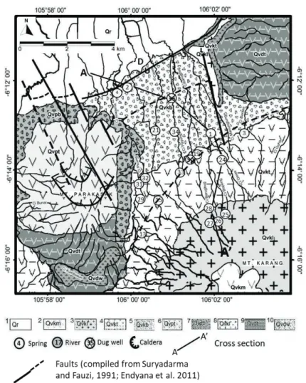
The study area consists of two volcanoes and wide swamp filled with debris of volcanic product such as tuff and clay deposits. According to Rusmana et al. (1991) and Santosa (1991), the volcanic activity in the study area started Late Pleistocene, where the volcanic activities had continued to the Holocene, and formed the oldest volcanoes such as Mt. Karang and Mt. Parakasak. The highest point of Mt. Karang is 1778 meters above sea level (a.s.l). The oldest rocks in the study area are composed of andesitic to basaltic lava product of the Mt. Kamuning unit; tuff of old volcanic (Banten tuff), volcanic breccias of the Mt. Parakasak unit; lapili tuff of Mt. Parakasak unit; volcanic breccias of the Mt. Karang unit; tuff of the Mt. Karang unit; andesitic to basaltic lava of Mt. Karang unit; pyroxene andesite-basalt of the Mt. Karang unit and sediment in Rawa Danau (Figure 1). Normal fault with a strike direction southwest-northeast controls the appearance of springs in the study area.
Hydrogeological setting
Sukrisna et al. (2004) divided Banten Province into four groundwater basins based on the hydraulic properties. Four groundwater basin in Banten Province: Labuan, Rawa Danau, Malingping, Serang and Tangerang. The study area belongs to the Rawa Danau basin and has discharge rate of 180x106 m3/yr for unconfined aquifer and 13x106 m3/yr for confined aquifer and an area about 375 km2 (Sukrisna et al., 2004). West Java belong to humid-tropical climate which is characterized by the presence of a dry season started from June to September and a rainy season from November to March.
3. METHODOLOGY
Nineteen groundwater samples were collected in the northern part at Mt. Karang and Mt. Parakasak in the elevation range from 126m to 688 m a.s.l as shown in Fig 1. Water samples were filtrated with 0.45 µm membrane filter and stored in polyethylene bottles in situ. pH, temperature and electric conductivity (EC) were measured in the field. Cations (Li⁺, NH4⁺, Na⁺, K⁺, Mg²⁺ and Ca²⁺) and anions (Cl⁻, SO42- and NO3-) were analyzed using ion
chromatography (Dionex ICS-90). HCO3 was analyzed by the titration method with 0.1 M HCl soon after the sampling. Water isotopes (δ18O and δD) were determined using the CO2– H₂ equilibration method (Epstein and Mayeda, 1953). Then, the isotope ratios were measured using DELTA Plus mass-spectrometer. These internal standards were calibrated using international reference materials V-SMOW with analytical precisions of ±0.1‰ for δ18O and ±1‰ for δD.
Figure 1 Geological map of Mt. Karang and sampling location area showing the lithological unit (1 sediment in Rawa Danau; 2 pyroxene andesite-basalt Mt. Karang; 3 andesitic-basaltic lava Mt. Karang; 4 tuff Mt. Karang; 5 volcanic breccia Mt. Karang; 6 lapili tuff Mt. Parakasak; 7 volcanic tuff (tufa Banten); 10 weathered tuff, part of the ancient volcanic lake product) and faults (Suryadarma and Fauzi, 1991; Endyana et al., 2011), modified from Rusmana et al. (1991) and Santosa (1991)
4. RESULT AND DISCUSSION
In general, the groundwater in the study area were emerge by faulting alignment, which is assumed to be oriented along the northeast to southwest and west to east direction. According to Sudibyo (1990) and field survey, three different aquifer systems have been identified in the
study area: volcanic breccia aquifer (combination between porous and fractured), Mt. Karang lava aquifer (fractured), and Mt. Parakasak lapilli tuff aquifer (porous media).
The pH values of groundwater samples are generally of neutral or slightly acidic with ranging from 5.0 to 7.6. Water temperatures are in the ranges from 22.3 to 27.1⁰C and Electrical conductivity (EC) values were measured to be 3.98 – 193 mS/m.
The chemical contents especially major element from groundwater samples showed Na⁺ with average values 7.8 mg/l, K⁺ 2.9 mg/l, Mg²⁺ 3.5 mg/l, Ca²⁺ 11 mg/l, Cl⁻ 2.8 mg/l, SO₄²⁻ 4.7 mg/l and HCO₃ ⁻ 61.9 mg/l. Dominant cation Ca²⁺ indicated this water flowed in the formation of andesitic-basaltic rock that contain Ca-plagioclase. The high Na+ in a few analyzed water samples may be derived from weathering of feldspar minerals or any member of the plagioclase or solid solution series between albite and anorthite (Appelo and Postma, 2005). Meanwhile, HCO₃ is derived from infiltration of rain water equilibrated with CO² in atmosphere or is CO² generated by root respiration organic material.
The results of chemical analysis for the groundwater were plotted on a piper diagram as shown in Figure 2. There were divided into three groups based on their chemical characteristics: Ca-Na-HCO\, Ca-HCO3 and Na-Ca-HCO3. However, shifted in Ca, Na and HCO3 in several groundwater samples may be due to mineral compounds in the aquifers where water-rock interactions occur. The different stratigraphic horizons, which are characterized by different rock types, may have contributed to the chemistry of percolation waters.
Figure2. Piper diagram from groundwater samples in Mt. Karang
The measured δD and δ¹8O are plotted in Figure 3 together with the global meteoric water
line. All samples are plotted along this line, implying that they are meteoric water origin. This indicates that precipitation is the main recharge source of the resources of groundwater in this
area. The stable isotope values of δ¹8O in groundwater samples are in the range from -7.1‰ to -5.6‰ and δD from -43‰ to -36‰, respectively.
Most of the groundwater samples derived from springs and dug wells demonstrates relatively heavy in deuterium. The heavy concentration of deuterium in these samples implies that the waters are flowing in the shallow aquifer. Possible cause for the enrichment of deuterium is the partial evaporation of water due to evaporation of shallow groundwater before it completely infiltrates into the recharge zone. Moreover, in shallow and unconfined aquifer, the change in temperature may also cause the enrichment of the deuterium.
Figure3. Stable isotopes of δ¹⁸O versus δD
The groundwater flow system in Mt. Karang is illustrated in Figure 4. The figure represents a cross section indicated by the line A-A’ in Figure 1. One of the characteristics in terms of hydrology in the study area is that there are many springs on the slope and on the foot of Mt. Karang. These spring waters are natural discharge from aquifers developed in volcanic rocks such as lava, breccia and tuff formations. Stable isotope analysis of waters indicates that the source of groundwater is rainwater and river water receives significant evaporation effects resulted in enrichment of heavy isotope. Groundwater flowing very shallow depth may also receive the same evaporation effects.
Therefore, groundwater can be divided into two groups: one is represented by KR-27 in Figure 4 that is discharged by mixing with surface or is flowing very shallow aquifer experiencing evaporation and the other one represented by KR-1 and KR-2 that discharges with large flow rate from deep aquifers without any mixing with surface water. These groundwater may be related to a presence of fault system. Springs of KR-26 and KR-28 are located close to KR-27. Values of δD of these spring waters are lighter compared to other
samples implying these water flowing in deep aquifer.
Figure4. Schematic of groundwater flow systems in the Mt. Karang aquifer system
5. CONCLUSION
In general, spring water discharges on the slope and the foot of the northern part of both volcanoes. The pH groundwater is basically neutral and EC values range from 5.0 to19.0 mS/m. Results from chemical analysis were plotted on a piper diagram and all samples fell in the same Ca-Na and HCO₃ corner. Isotope values of water samples are plotted close to the global meteoric water line, implying that their source is meteoric water origin. A conceptual model of groundwater flow system in Mt. Karang was constructed on the basis of the hydrogeological, hydro-chemical and stable isotope data.
ACKNOWLEDGEMENT
The authors would like to extend their gratitude to GCOE program, Kyushu University for providing financial support for this study. The authors would also like to thank deeply to Faculty of Geology, University of Padjadjaran and the Unpad team for their invaluable participation in this study.
REFERENCES
Appelo, C.A.J., and Postma, D., 2005. Geochemistry, Groundwater and Pollution. Leiden, A.A. BalkemaPublisher.
Craig, H., 1961. Isotopic variations in meteoric water. Science, 133, 1702-1703.
Endyana, C., Hirnawan, F., Hendarmawan., Mardiana, U., 2011. Pendugaan nilai tahanan jenis batuan sebagai upaya untuk mengetahui struktur geologi yang berkembang pada endapan volkanik di Kec. Padarincang, Provinsi Banten. Bulletin Sumber Daya Geologi, 6, 23-2. (In Indonesian)
Santosa, S., 1991. Geology of the Anyer Quadrangle, West Jawa, 1:100,000 explanatory notes and geological map Bandung: Geological Research and Development Centre, Bandung, P.32
Rusmana, E., Suwitodirdjo, K., Suharsono., 1991. Geology of the Serang Quadrangle, Jawa, Scale 1: 100,000 explanatory notes and geological map Bandung: Geological Research and Development Centre, Bandung, P.19
Sudibyo, Y., Takmat, U., Sunarya, Y., 1995. Peta Hidrogeologi Indonesia, 1:100,000. Lembar 1109-6 & 1110-3 Serang. Bandung: Direktorat Geologi Tata Lingkungan (In Indonesian).
Suryadarma and Fauzi, A., 1991. Hydrothermal alteration of the Garung, Banten geothermal area, West