*Corresponding author: e-mail morooka@kochi-u.ac.jp
From the Kuroshio Triangle to the Kuroshio-Related S-Shaped
Zone: Introductory Remarks for the 4th Symposium
Yoshinori Morooka
*and Akira Tominaga
Graduate School of Kuroshio Science, Kochi University, Kochi 780-8520, Japan Abstract
In 2009, the three participating countries – Japan, Taiwan, and the Philippines – completed a round each of holding the Annual Symposium; thus, from this year, Kochi University has been exploring means of further pursuing research development among the collaborating partners. As an outcome, placing emphasis on the Kuroshio Triangle, we decided to reveal our concept of linkage among moun-tains, rivers, and seas. At the same time, we also decided to take up the topic of how recent societal changes and modifications to the natural environment have affected coastal and land-based environ-ments. This Symposium will especially focus on islands/archipelagos of the Kuroshio region that have engaged in cultural exchange from a very early time in history. Here, universities and institutions representing the three countries will form a nucleus for a network to which will be added Malaysia’s Sarawak State, which possesses vast tropical forests, and West Kalimantan of Indonesia. With this development, we expect to achieve even more enhanced information exchange concerning the effects of climate change on the ecology of coastal and land-based areas of the Kuroshio region. The addi-tion of these countries to our network will expand the Kuroshio Triangle to form a new domain, named here as “The Kuroshio-Related S-Shaped Zone”. Representative universities from Malaysia and Indonesia will be concerned with addressing ecological and environmental problems that extend beyond national boundaries.
Key words: comprehensive science, Kuroshio Triangle, Kuroshio-Related S-Shaped Zone
1. Progress during the 1st to 3rd Joint Kuroshio Symposiums
The Kuroshio Current commences off of the eastern coast of the Philippines, passes the southern coast of Taiwan, and continues northwards to Japan in the Pacific. Targeting the sea areas linking the three countries (the "Kuroshio Triangle"), Kochi University and other par-ticipating universities in Taiwan and the Philippines are working together in an effort to exchange scientific infor-mation and researchers, with the purpose of conducting investigations and studies on coastal ecosystems.
In the Philippines, we concluded an agreement with the University of the Philippines, which is a focal point of scientific studies in that country; Bicol University, located where the Kuroshio has its origin, and boasting a long history of research in Fisheries Science with a large store of results; and the Bureau of Fisheries and Aquatic Resources of the Department of Agriculture. We have also initiated a joint project in Taiwan, where the “Study Group on the Kuroshio Current” was established at the
Asia and Pacific Ocean Study Center of National Sun Yat-sen University. In 2008, we drew up an “action plan” for holding symposia to examine the achievements of the above joint studies, and have successfully carried out such symposia every year. The output of the past three symposia has been published in the English proceedings of the Kuroshio Science, including this issue (Vol. 2, No. 1; Vol. 3, No. 1; and Vol. 4, No. 1).
2. Reexamination of the Kuroshio region
As of 2010, the Kuroshio Symposium has been held once in each of the three participating countries, and this has enabled Kochi University and the other organiza-tions to hold discussions concerning their future research activities. As a result, it was agreed to plan a symposium for expanding study projects from marine areas to land areas, taking into account future cooperation with island areas in Southeast Asia, e.g., the so-called “Kuroshio cultural zones” with which we have had active exchange from a very early time in history. This plan is based on
our standpoint of attaching great importance to the fol-lowing: 1) studies on adaptation to changes in natural phenomenon, including climate change in recent years, and 2) studies on the impact of increasingly global changes in economic activity and lifestyles on envi-ronmental problems, with major emphasis placed on research on the marine areas of the Kuroshio Triangle.
Against this background is our recognition that the deterioration of the ocean environment is closely linked with and related to changing conditions in land areas. From this viewpoint, we made a decision to add organizations in Sarawak State in Malaysia, and West Kalimantan Province in Indonesia, to our research net-work. Both of these places harbor vast tropical rain for-ests, and through this new partnership, it is hoped that we can upgrade the exchange of scientific information concerning the diverse effects that climate changes have on the ecosystems of both land and marine areas. Japan, Taiwan and the Philippines form the "Kuroshio Triangle" and are located in the "Kuroshio-Related S-Shaped Zone" (refer to the figure on page 4); all three countries are faced with cross-border environmental problems, i.e., deteriorating ecosystems.
3. Objectives of the 4th International Symposium The Fourth Symposium to be held in Kochi, Japan, aims at (1) summarizing the present state of the marine and land ecosystems in the Kuroshio-Related S-Shaped Zone, (2) exchanging information on the results of related studies, and (3) formulating the direction of investigations and research that will be conducted jointly in the future. Based on this new perspective, "Diverse effects of artificial impact on marine and land areas of the Kuroshio region" was selected as the theme for the Fourth Symposium. It is expected that scientific net-works related to the Kuroshio will further expand, which in turn will provide greater impetus to our investigative and research activities.
4. Background of Studies on the Kuroshio Region In 2004 at the time when national universities across Japan were reorganized as national corporations, Kochi University initiated studies on the integration of the humanities and natural sciences with the aim of establishing "comprehensive sciences relating to the Kuroshio region." This section of the manuscript outlines the background of activities that led to the creation of this new field of science. Quotes and information from a paper written by Dr. Kimio Fukami of Kochi University
are introduced. How this new science is linked with the goals of purposes of the 4th Symposium is summarized below.
1) Comprehensive science for the Kuroshio region
According to Dr. Fukami’s views, "Comprehensive science for the Kuroshio region" is the study of the nat-ural environment and regeneration mechanisms of biore-sources. Kochi Prefecture, above all other parts of Japan, exemplifies the “blessings of the Kuroshio”. The "bless-ings of the Kuroshio" are brought about by ample pre-cipitation and the mild climate provided by the Kuroshio, which is one of the largest warm water currents in the world. To use these blessings as effectively and sustain-ably as possible, we should possess full knowledge of the ecosystem of mountains and seas affected by the Kuroshio ("Kuroshio region"), and study the region's resources and environment in an integrated way. Along these lines, one of our goals is to build up eco-friendly food production systems.
Based on the above, Kochi University is conducting studies on the sustainable use of agriculture, forestry, and marine resources while conserving and maintaining the environment and ecosystem. In this way of thinking, the mountains (forests), rivers, rural areas and seas in the Kuroshio region are regarded as one single system. We hope that participants in the past three international sym-posia will understand why we have focused past studies on marine areas, and that they understand and accept our proposal that subsequent studies on the "Kuroshio Triangle" will not only look at the linkage among Japan, Taiwan and the Philippines, but will also encompass studies on land areas.
2) Insights obtained from investigations on the Niyodo River
Japan is divided into 47 administrative districts, and Kochi Prefecture has the highest percentage of forest area (84%) out of total prefectural area throughout the country. In Kochi Prefecture, three large rivers (the Shimanto, Niyodo and Monobe) flow from the mountains into the Pacific Ocean. Dr. Fukami’s team has continued to publish valuable data on the impact of nutritive salts supplied by the Shikoku Mountains on biological pro-duction in rivers using the basins of the Niyodo River as the study site. This data has received much attention, and some of its recent achievements are outlined below:
The study team investigated the concentrations of nutrient salts in rains, spring water from forest soils, and river water in the basins of the Niyodo River. As a result, it was found that because rains pass through forest
soils, large quantities of nutrient salts are supplied from forests to river water. Nitrogen (N) content in spring water was more than that in rain by a factor of 4.5-fold on the average; that of phosphorus (P), 8.9-fold; and that of silicon (Si), 350-fold. This revealed that forest soils are a very important supply source of nutrient salts to river water. It was also discovered from the N:P:Si ratio obtained that the content of phosphorus is relatively low in this river, while that of silicon is high. Detailed data on the existing quantity of free-floating substances and adhesive microalgae in the river water was also obtained. Subsequent studies revealed that the greater portion (more than 80%) of the nutrient salts in the river water is transported up to the river mouth area, and thereby contributes to primary production by phytoplankton in coastal brackish waters, and to the growth of seaweeds and seagrasses.
These findings detailed above are also supported by previous studies, for example, a report compiled in 2004 by Dr. Masayuki Takahashi, a chairman of a joint survey project conducted by the Ministry of Agriculture, Forestry and Fisheries (MAFF) and the Ministry of Land, Infrastructure and Transportation (MLIT). The report emphasizes that nutrient salts, micro-elements, and organic materials, as well as large quantities of water, soil and sand that come from up-stream forest and river sites contribute towards the amplification of resources in marine ecosystems (MAFF and MLIT, 2004). However, the report also stresses that further in-depth studies on methodology and enhancing data accumulation are
nec-essary. Thereafter, diverse investigations focusing on the linkage between mountains, rivers and seas have been carried out by organizations in Japan such as the Chiba Biodiversity Center (CBC, 2010) and the Ocean Policy Research Foundation (OPRF, 2011).
3) Linkage of mountains, rivers, rural areas and seas
The results of the above-mentioned studies have revealed to us that the mountains and seas are inseparably linked through the river environment. Such research has promoted much interest in the relationship among moun-tains, rivers, rural areas and seas. For example, an oyster farmer from Miyagi Prefecture, and some of his cohorts, have been taking part in tree planting, thinning and other forest work activities in upstream river areas since the mid-1980s. As a new study area, Kyoto University has initiated programs to help students understand the link-ages between forest biospheres, human ecosystems and marine biology. The former director of the Research Center, Dr. Masaru Tanaka, says, "The natural environ-ment of Japan consists of three ecosystems--forests, coastal seas and human habitats, all of which are insepa-rably interconnected." He continues, "Traditionally, these ecosystems have been studied separately, but human activities have overwhelming influences over the inter-relations between the ecosystems. Therefore, it is impor-tant to elucidate the coexisting interactions between the natural ecosystems and human beings" (See Glossary on p. 5).
In this 4th Symposium, we plan to take account of
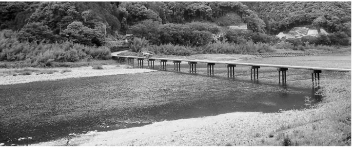
Figure 1. A "Chinka-bashi" on Niyodo River in Kochi Prefecture.
A "Chinka-bashi" is a type of bridge equipped with low girders that minimize damage by floods during heavy rain. In conventional bridges, driftwood and other material coming from upstream are trapped by the bridge, and this causes flooding. However, in the case of a "Chinka-bashi", because the girders are lowered, extraneous material flows over the bridge during heavy rain, thus minimizing flooding. This area had long experienced flood damage, and adoption of the "Chinka-bashi" design has helped to mitigate such prob-lems.
these recent trends and present a framework of thinking that connects conservative studies on marine areas with those on land areas. Traditional fields of study have been subdivided a great deal with the progress of sci-ence; however, we would like to explore together with participants the real meaning of expanding our scientific viewpoints to address the problem of environmental deterioration. We hope to promote a multifaceted way of thinking, and at the same time, strive to continue wid-ening our study areas.
5. Tentative Schedule of the 4th Symposium The aims of this Symposium are as outlined above, and we will need to have several sessions of brain-storming in the months ahead so as to reach a certain level of mutual understanding concerning the theme of the Symposium. Partly because time is limited, we have decided to divide the presentation of topics into
"Marine-area studies" and "Land-"Marine-area studies" and to ask the participants in the latter session to pose the problem of how to link mountains, rivers, rural areas and seas. The overall schedule of the symposium is roughly as follows: November 6 (Saturday): Reports mainly on "Marine-based studies"
November 7 (Sunday): Reports mainly on "Land-based studies" (afternoon: visit to the Jidai Festival)
November 8 (Monday): Tours to Tosa Bay and Muroto Point areas
The first day will be wholly devoted to reports on "marine-area" studies because these studies have long been conducted jointly in the Kuroshio Triangle (i.e., formed by Japan, Taiwan and the Philippines), and many achievements have been produced on the basis of these investigations thus far. On the other hand, this is the first occasion that "land-area" studies will be reported at the Figure 2. Creation of sustainable fishing grounds taking into account the importance of the linkage among forests, rivers, and seas.
① Proper management of artificial forests, ② Mitigation of soil erosion, ③ Establishment of purification facilities, ④ Regulation of soil and sand collection from river or coastal areas, ⑤ Conservation of bushes and mangroves along river areas, ⑥ Construction of routes for fish movement and migration, ⑦ Conservation of beaches and sandy hills, ⑧ Conservation of seaweed/seagrass beds, ⑨ Maintenance of the appropriate functioning of the flow of materials from the sea to land areas (Illastrated by Sayaka Oishi, Student, Kochi University)
Symposium, and thus we plan to lay emphasis on deep-ening our mutual understanding in relation to the chief topics discussed for each of the countries and regions. Therefore, while the sessions on the first day will take the form of symposia, the second day will feature more workshop-style sessions.
6. Excursions
The schedule for the Fourth Symposium has been planned to coincide with the "Kino Tsurayuki Jidai Festival," which is held annually in Nankoku. Kino Tsurayuki (872-945?) was a Tanka poet who produced remarkable work more than 1,000 years ago in the Heian Era (794-1192). He came to Kochi to take office as the provincial governor and lived in the present Nankoku area from 930 to 935. Kino Tsurayuki is well-known as the author of the "Tosa Nikki" ("Diary in Tosa"; Tosa being the old name of Kochi Prefecture). It was written after his return to Kyoto, the capital of Japan during the Heian Era, and is considered to be the oldest example of a diary in Japan. We hope that
vis-iting this festival commemorating the great poet will give the participants from abroad a chance to learn about Japan’s history, and the days of Kino Tsurayuki more than thousand years ago.
For the excursion program on the third day, we will offer two options: a cruise in Tosa Bay, or a visit to a deep seawater production facility in Muroto Point, located far from Kochi City. The first option will feature a visit to a fishing community, Usa Town in Susaki City, which is known as a gathering place for whales in Tosa Bay, particularly Bryde's whales. Usa is a small town which still preserves the appearance of an traditional fishing village and is a popular tourist spot for sight-seeing, enjoying seafood, and going on whale-watching
cruises. Such activities are strongly supported by the municipal government, in order to promote the city’s development and stimulate the local economy.
The second option will be an opportunity to view the present state of activities in industrializing deep seawater as carried out by Muroto City. Deep seawater is obtained from the ocean at a depth of 200m or more, and is known for its properties of cleanliness, high content of inorganic salts, stable low temperatures and low dissolved oxygen content. Because of these useful characteristics, much effort has been made to develop products using deep seawater, such as health drinks, toiletry and lotions, and bath salts. At present, there exist about 20 facilities for the utilization and processing of deep seawater in eleven prefectures in Japan, and the establishment at Muroto is one of those which are noted to be especially successful. During the excursion, participants will be able to obtain basic information concerning the collection and usage of deep seawater, and view the latest technology related to such endeavors.
References
MAFF and MLIT. 2004. Survey report for sustainable use of fishing grounds from the viewpoint of the role of linkages among forests, rivers and seas. (in Japanese)
CBC. 2010. Report of the Chiba Biodiversity Center. (in Japanese)
Fukami, K. 2011. Development of comprehensive sci-ences relating to the Kuroshio Current zone: The role of rivers in connecting mountainous areas with the sea. Ship & Ocean Newsletter No. 251, OPRF (Ocean Policy Research Foundation), pp.2-3 (in Japanese)
OPRF. 2011. Survey report on integrated management of forests, rivers and seas. (in Japanese)